Using Cloud Services to Support Environmental Streamlining
What Makes Cloud Services Unique?
Many traditional computer applications require front-end user interfaces directly connected to back-end systems that actually run a program. Cloud services share back-end systems, leveraging the combined computing power provided by these systems. There are different kinds of cloud services: some allow users extensive flexibility to build highly customized applications while others offer users “out of the box” applications that limit customization.
In either case, with a web browser serving as the front-end interface, users of cloud services can share and access information when, where, and how they want it, such as through a desktop computer, mobile phone, tablet, or other device.
There are four main user models for cloud services:
- In a private cloud, a single organization (e.g., a State DOT) provides services for internal users.
- In a community cloud, services are provided to a specific group of users who may represent different organizations but have a shared set of interests.
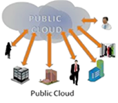
- In a public cloud, services are provided for use by the general public.
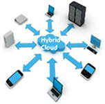
- A hybrid cloud provides services combining two or more of these models. Across all models, cloud computing infrastructure may be provided, owned, managed, and operated by one organization, a third party, or a combination of both.


The images above illustrate how a hybrid cloud (left) and a public cloud (right) share data among cloud users and on different platforms. (Courtesy of www.armedia.com).
The Federal Highway Administration (FHWA) is promoting “cloud services” as tools that State Departments of Transportation (DOT), metropolitan planning organizations, and other transportation agencies can use to expedite project delivery and facilitate environmental streamlining. “Cloud services” refers to the use of shared computing resources, such as a pool of networks or servers, to store, process, or distribute information. Cloud services are powerful tools that can support project development and environmental streamlining through data sharing and collaboration, focusing the use of resources to minimize redundancies, and improving data quality. While the idea of sharing resources is not new, using the term “cloud services” to describe how these resources operate is a relatively recent trend.
FHWA’s promotion of cloud services to support environmental streamlining is part of the agency’s larger Geospatial Data Collaboration (GDC) initiative. The GDC initiative encourages transportation agencies to use geospatial tools, including those that are cloud-based, to share data, increase collaboration, and improve the quality and speed of transportation decisionmaking. GDC is one element of FHWA’s Every Day Counts (EDC) initiative, which aims to produce innovations, resources, and partnerships to shorten project delivery, enhance safety, and protect the environment. EDC and GDC also leverage other ongoing FHWA efforts such as Planning and Environment Linkages (PEL), which promotes a collaborative and integrated approach to transportation decisionmaking, and Eco-Logical, which promotes collaboration and data sharing to determine environmental priority areas during transportation planning. All of these efforts are helping transportation stakeholders work together for smarter, faster decisionmaking and better transportation projects.
Examples of Cloud Services
FHWA is conducting research to identify examples of how transportation agencies are using cloud services for project development, environmental streamlining, and improved geospatial analysis. This research involves developing a series of case studies to highlight agencies’ experiences. These case studies include summaries of cloud-based applications developed by the Utah Department of Transportation (UDOT) and the Idaho Transportation Department (ITD), which are briefly described below.
UDOT’s UPlan
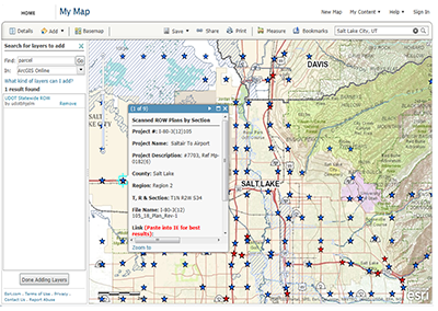
UPlan is a cloud-based, interactive mapping tool that compiles, integrates, and displays a wide range of transportation and environmental data compiled from UDOT sources and others, including State and regional agencies and the private sector. Initially developed in 2007 as a resource to support transportation planning, UPlan has evolved to address multiple goals over time. The tool currently functions as an information clearinghouse, a platform to support geospatial analysis of transportation projects, and as a mechanism to improve collaboration within UDOT and between the agency and its stakeholders. UPlan users include staff from UDOT, natural resource agencies, and members of the public, among others. Since UPlan is cloud-based, anyone with a web browser can access the tool to view information; however, only subscribers can upload data (subscribers are typically organizations, but can include individuals). Subscribers pay an annual fee to Esri, a private mapping software company, which provides cloud technology for UPlan. UPlan exemplifies a hybrid cloud model. UDOT stores some of UPlan’s more sensitive data, while Esri stores non-sensitive data on its own servers. Additionally, many data layers are stored and provided by third-party owners, including State and regional agencies.

UPlan allows users to produce customized maps with transportation and other data from a variety of sources. (Courtesy of UDOT)
UPlan has helped UDOT to strengthen its partnerships with natural resource agencies to improve project delivery by accelerating the review process. In the past, UDOT and the Utah Division of Wildlife Resources (DWR) staff typically shared information by exchanging paper maps of proposed transportation projects. Using these maps, DWR staff would provide comments to UDOT about a project’s potential environmental impacts, but the paper map format limited DWR’s ability to provide detailed feedback. Now, using UPlan, UDOT staff can easily create a map that overlays natural resources data, such as an animal migration path, onto a transportation project map and share this map with DWR staff, who can then modify the map as needed to assist with their analysis. Because UPLAN is cloud-based, DWR staff can also access the map without specialized software, passwords, or other mechanisms to access the UDOT data. As a result, DWR staff can more easily provide thorough feedback, speeding up the review process.
UDOT also developed a PEL tool for use with UPlan to help staff assess how transportation project alternatives might affect natural resources and to develop categorical exclusions (CEs) and other analyses related to the National Environmental Policy Act. This used to require days or weeks of work, but through UPlan, staff can complete these analyses in just a few minutes, reducing costs and saving time. For example, developing a CE, which determines whether certain actions have significant environmental impacts, now costs approximately $1,000 with the PEL tool, instead of roughly $50,000 without it. Through these general time and cost savings, the use of UPlan contributes to a more efficient project development process.

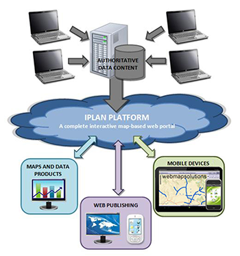
Like UPlan, IPLAN exemplifies a hybrid cloud model. (Courtesy of ITD)
ITD’s IPLAN
ITD’s IPLAN, currently in development, is based on UPlan’s model. ITD is working closely with UDOT in developing IPLAN. This collaboration is underway as part of the American Association of State Highway and Transportation Officials’ (AASHTO) Technology Implementation Groups (TIGs). The TIGs provide resources to transportation agencies to advance select transportation technologies and innovations. UDOT and ITD jointly worked with AASHTO to establish a TIG comprising 13 States, including Utah and Idaho. This TIG explores how to best build and use cloud-based, collaborative geospatial tools like UPlan in other States beyond Utah. IPLAN is serving as a TIG pilot tool that ITD and other TIG States can use to identify lessons learned and success factors. Esri and Bio-West, a consulting firm, are providing pro bono technical capabilities to assist the TIG States with tool implementation.
Like UPlan, IPLAN is a cloud-based, interactive mapping tool that will compile a range of transportation and environmental information from ITD and other sources. IPLAN aims to support data sharing within ITD and collaboration between ITD and other stakeholders, particularly natural resource agencies, and to speed project development and delivery. Like UPlan, IPLAN is an example of a hybrid cloud.
As a cloud-based application, IPLAN will enable transportation and environmental stakeholders from different agencies to access the same datasets via a web browser. This will reduce the need to email or send data files to non-ITD users who cannot access information behind agency firewalls. Additionally, because data owners can make updates in near real time using cloud technology, users will be able to access information that is more accurate and consistent. Overall, ITD anticipates that IPLAN will assist stakeholders in identifying potential problems earlier in the project development process, reducing the potential for conflict and contributing to significant time and cost savings in the environmental review process.
Benefits of Cloud Services for Streamlining
These case studies demonstrate that cloud services can contribute to environmental streamlining through enhancing partnerships, information accessibility, and data consistency. To provide capacity-building opportunities and convene agencies that participated in the case studies, FHWA will sponsor a follow-on peer exchange in May 2013 in Boise, Idaho, which ITD will host. The peer exchange will explore six transportation agencies’ experiences using cloud services for streamlining and for geospatial analysis, focusing on sharing best practices and identifying new areas of opportunity in the field. FHWA will produce a report from the case study research and peer exchange that highlights findings, lessons learned, success factors, and best practices. When completed, the report will be available on the FHWA GIS in Transportation website.
Through the May 2013 peer exchange, case study report, and other activities associated with the GDC initiative, such as virtual summits held in conjunction with EDC, FHWA seeks to promote a broader community of practice for cloud users to share lessons learned and better understand how cloud services can support streamlining through improved geospatial analysis and collaboration. Transportation agencies can learn from these successful practices to take advantage of existing cloud technologies or build new ones that improve project delivery.
Look What’s New!
- In March 2013, FHWA released the fourth edition of Eco-Logical Successes, a report on Federal agency initiatives to implement the Eco-Logical approach to integrating ecosystem conservation into infrastructure development. The report features the U.S. Army Corps of Engineers’ Watershed-Based Mitigation Approach the Environmental Protection Agency’s Regional Ecological Assessment Protocol, and the National Oceanic and Atmospheric Administration’s Integrated Ecosystem Assessment Approach.
Successes in Stewardship is a Federal Highway Administration newsletter highlighting current environmental streamlining and stewardship practices from around the country. Click here to subscribe, or call 617-494-2092 for more information.

