Alabama
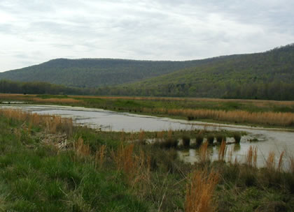
Crow Creek mitigation bank in Jackson County, AL, is the
restoration of a 470-acre bottomland hardwood forest wetland
system that includes the creation of a waterfowl management area.
Photo courtesy of Patricia Bacak-Clements, USFWS
Program Contacts
John Shill
Assistant Environmental Coordinator
Alabama Department of Transportation
1409 Coliseum Boulevard
Montgomery, AL 26130
Phone: 334-242-6132
Email: shillj@dot.state.al.us
Bill Van Luchene
Environmental Engineer
FHWA-Alabama Division
500 Eastern Blvd., Suite 200
Montgomery, AL 36117
Phone: 334-223-7379, Fax: 334-223-7325
Email: William.Van.Luchene@fhwa.dot.gov
Program History and Philosophy
The State of Alabama Department of Transportation Wetland Mitigation Bank Program has grown from a single 80-acre wetland bank in 1991 to a total of 13 wetland banks today, covering 5,397 acres. The primary catalyst for the program was an increase in project delays at the permitting stage due to inter-agency differences over mitigation ratios. On-site mitigation had become increasingly more difficult to plan, implement, and maintain. Furthermore, efforts to create high quality, sustainable on-site mitigation were often compromised by pre-existing ecological impediments (e.g., inadequate hydrology, poor soils, invasives, etc.) that had to be addressed continually. Wetland banking offered Alabama DOT the opportunity to dispense with an inefficient project-by-project mitigation approach in order to mitigate for unavoidable wetland impacts through a more efficient programmatic framework that would ensure the conservation of higher quality wetland and habitat resources.
The Alabama DOT (ALDOT) has experienced essentially two phases of its banking program: one before the issuance of the 1995 Federal guidance, and one after. During the early years of its "first" banking program, ALDOT experienced good coordination with the resource agencies and local governments that were signatories on the banking instrument. Federal dollars were utilized at that time to purchase and establish one of the department's mitigation sites. The sites were quickly put "on the ground," and the credits generated by the sites were released immediately and pooled, as opposed to being released in phases and assigned to individual sites. The banking program was set up in the department as a "highway fund project" for use by State- and Federal-aid highway projects exclusively. ALDOT's small, dedicated staff of in-house biologists coordinated all aspects of mitigation, from site selection, to design, to implementation, and this generally applies today.
In the mid-1990s, ALDOT's attempts to formulate an updated memorandum of agreement for its banking program were stalled for three years until the issuance of the 1995 Federal Guidance for the Establishment, Use, and Operation of Mitigation Banks. The statewide banking agreement was finalized in April 1996, although changes are being considered currently at the request of EPA to address mineral rights issues, a growing concern in the State. Under the 1996 banking agreement, oversight of ALDOT's banking program became governed by the MBRT, chaired by the Mobile COE District Office, which covers the largest area of the State, although a second COE District Office (Nashville) also has jurisdiction in the Tennessee Valley region.
ALDOT believes that the MBRT concept is a sensible step forward and will benefit wetland conservation in the State for the long term; however, the MBRT process is still being refined to reconcile "start-up" challenges related to the introduction of new personnel to the process and to philosophical differences over wetland function definitions and performance standards.
Soon after the establishment of the MBRTs, private banks began to emerge in the State, and the question of how much mitigation should cost became an important issue of concern. One private bank initially charged $35,000/credit (per acre fill), while the costs of ALDOT-owned banks at the time typically ranged from $5-$10,000/credit. As a result, for many years ALDOT opted not to purchase credits from entrepreneurial banks because the costs were considered prohibitive and not a reasonable expenditure of public funds. However, as market factors have stabilized these costs over the years, ALDOT has renewed its interest in working with private banks as potential partners. ALDOT recently acquired approximately 50 credits from a private bank and plans to acquire 200 additional credits in the near future.
To date, 95 percent of ALDOT's mitigation is provided by its own banks, which are acquired as fee-simple real estate with deed-restricting covenants. County and local transportation agencies are not eligible to receive credits from ALDOT banks. These agencies and other organizations seeking wetland credits for economic development projects can use entrepreneurial banks or a program operated by the Alabama Wildlife and Freshwater Fisheries Division. The Nature Conservancy (TNC) is also actively buying land in Alabama for wetland preservation with funds from the Natural Resources Conservation Service (NRCS). On occasion, TNC has operated as an in lieu fee provider of wetland credits for private developers and construction contractors. TNC has also assisted ALDOT with finding potential mitigation sites, although no formal collaboration between TNC and ALDOT exists at this time. Some coordination at a broader level would be helpful, ALDOT believes, to guide situations where TNC, for example, conducts a mitigation project at an upstream site location, while ALDOT concurrently conducts a separate mitigation project at a downstream location in the same river basin. Currently, no guidelines exist to help ensure that mitigation projects implemented by different organizations throughout the State are serving broader, complementary objectives.
ALDOT perceives stream mitigation as the next major environmental concern for the department. A consistent approach to addressing stream mitigation has not yet been adopted by the two COE district offices, Mobile and Nashville, having jurisdiction over ALDOT projects. ALDOT is seeking additional Federal guidance, but in the interim will likely consider bridging its streams as an immediate, although not necessarily cost-effective, solution to avoid and minimize potential impacts.
Site Descriptions and Operations
Wetlands cover about 10 percent of Alabama and range in size from small areas of less than an acre to the 100,000-acre forested tract in the Mobile-Tensaw River Delta. Most of the State's forested wetlands are bottomland forests in alluvial flood plains. Coastal waters support extensive salt marshes. Wildlife habitat is also a critical natural resource concern in the State. With the exception of Hawaii, Alabama contains the greatest number of endangered species in the country. Accordingly, the mitigation sites selected for ALDOT's wetland banking program are designed to serve both wetland and wildlife habitat functions.
Two of ALDOT's sites have received credits for habitat conservation for the gopher tortoise and the Egret sunflower, both listed species under the Federal ESA. The Styx River site in southern Alabama has been designed to manage several varieties of rare pitcher plants and other unique plants such as the Venus flytrap. Because of the scope and diversity of habitat concerns in the State, ALDOT is considering funding a position for a USFWS employee, who would be dedicated entirely to transportation projects, work out of the ALDOT headquarters office, and have the authority to write and approve biological opinions.
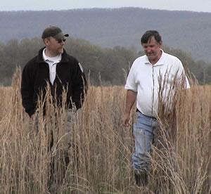
Rob Hurt, USFWS (left), and John Shill,
ALDOT (right) at Crow Creek mitigation site.
The mitigation sites are also being managed to promote public access and recreation as appropriate. ALDOT is developing a public environmental park in Montgomery County as part of the Catoma Creek wetland mitigation bank, a hunting area for the handicapped in the Dozier bank, and a waterfowl management area in Jackson County in the Crow Creek bank. The Sypsey Swamp site is part of a system that has been designated as a Natural Wonder of Alabama, and ALDOT has permitted limited public access to a number of persons and groups who want to visit the area. ALDOT allows hiking and fishing on most of its sites; however, due to safety issues, hunting is allowed only where ALDOT has agreements in place with the Alabama Wildlife and Freshwater Fisheries Division.
ALDOT has indicated that agricultural sites are the best suited for transformation into a wetland area. These sites are in a low stage of ecological succession so invasive plant species control is easier and more manageable. Clear-cut sites are in a recovering succession stage and more susceptible to invasive species growth. Most of ALDOT's bank sites are still in some stage of development and/or monitoring.
For the scan tour, ALDOT organized field visits to the following three mitigation sites:
- Crow Creek Mitigation Bank (470 acres; 150 credits approved)
Located in Jackson County in the Tennessee River Basin, this site involves the restoration of a bottomland hardwood forested wetland system and the creation of a waterfowl management area.
- Town Creek Mitigation Bank (530 acres; 170 credits approved)
Located in Lawrence County in the Tennessee River Basin, this site involves the restoration of a bottomland hardwood forested wetland.
- Flint Creek Wetland Mitigation Bank (650 acres; 430 credits approved)
Located in Morgan County, this private bank site is owned and managed by Robinsong Ecological Services, Inc. The bank was allocated approximately 215 "pre-credits" available for sale at bank approval. ALDOT recently purchased 50 "pre-credits" at $7,000/credit. ALDOT has entered into an agreement to purchase all remaining credits (approximately 215 maximum) that are released at the end of the prescribed five-year monitoring period in 2005.
Geographic Service Areas. The 1996 banking agreement specifies that the service area for each mitigation bank shall be defined by Alabama's nine river basins in addition to a coastal mitigation area. Currently, ALDOT has mitigation bank sites in eight of the State's nine river basins. The river basin service areas are much larger than the HUC-8 watersheds, allowing more frequent use of the bank sites as compensatory mitigation.
Functional Assessment Methodology. In the COE-Mobile District, which has jurisdiction over the majority of ALDOT's bank sites, the MBRT designated the following "mitigation acres:credit" ratios: 2:1 for restoration, 3:1 for creation, and 4:1 for enhancement. Preservation credits are negotiated with the MBRT on a case-by-case basis. ALDOT has only one preservation site, the Pea River Mitigation Site, located on the Pike/Barbour county line in the Chattahoochee/Choctawhatchee River Basin. The 600-acre site is a complete preservation of old growth cypress, hardwood, and tupelo gum swamp that was slated for lumbering. The MBRT is still clarifying some ambiguities in the language it uses to define restoration versus enhancement. For example, one dialogue that is ongoing between COE and ALDOT involves the implications of "clearing" a site on the mitigation. Currently, the act of replanting new trees and seedlings in a recently clear-cut area results in the mitigation being considered a restorationsite; whereas, replanting a site that has 5 to 10 years of natural re-growth (after having been previously clear-cut for agricultural use, for example) results in the mitigation being considered an enhancement site.
Monitoring Protocols. The COE-Mobile District MBRT has developed a regimented monitoring program that ranges from monitoring the success of plantings to prescribed burns. ALDOT uses an in-house team of environmental specialists to perform the monitoring of its bank sites. In addition, ALDOT has contracted with Tuskegee University, College of Agricultural, Environmental and Natural Sciences, to assist with monitoring both the Town Creek and Crow Creek sites. The university has been particularly helpful with implementing technologies, such as the use of barologger devices, to better document the hydrology of some of ALDOT's mitigation sites.
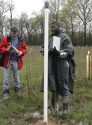
Barry Vaughn (center), Tuskegee University,
demonstrates barologger device to document
hydrology levels.
A barologger is a small, cylindrical pressure transducer device that can be installed within a well and positioned above the highest potential level of the water table to measure groundwater and surface water levels as well as the atmospheric, barometric pressure, and temperature levels. The Crow Creek Site has further release of credits dependent upon a successful demonstration of hydrology, which has been challenged by an invasion of ragweed and beavers. Proper hydrology is particularly important for forested wetland sites to help establish new tree plantings.
Accounting Procedures. As some of ALDOT's banks have yet to reach ecological maturity, the credits are released on a phased basis. The credits are increased by the MBRT as ecological performance standards are met over time. The bank ledger is then debited for impacts as per the designated ratios. ALDOT's documentation procedures are evolving in response to guidelines established by the MBRT. Because ALDOT's in-house staff of six biologists coordinate the design and implementation of all mitigation plans, the department has relied historically on a regular schedule of visual site inspections, as opposed to more formal accounting and ledgering processes, to characterize the progress of each site's functionality. However, this is changing now that the MBRTs have established more stringent monitoring protocols and a phased approach to the release of credits. To date, 80 percent of the approved credits from ALDOT's mitigation banks have been released.
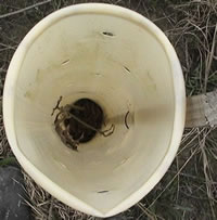
Maintenance and Management. Most of ALDOT's mitigation sites are currently in some phase of development and/or monitoring. Restoring proper hydrology is a key maintenance concern for many of the sites. Water control devices and wells are located on many of the properties, and the Clemson beaver dam leveler has been implemented to control impacts from beaver. Tree seedlings are protected from wildlife damage and from ragweed by planting within plastic tubes (see photo, right).
On some sites, hunting is being considered to control increased populations of feral hogs, which cause significant damage to tree plantings and new seedlings. Other mitigation sites are designed for waterfowl management areas where hunting is permissible as well.
ALDOT manages its wetland sites in perpetuity and in the manner required to meet the maximum acreage required by COE permits issued to ALDOT. However, with an annual maintenance budget of only $30,000, ALDOT has sought additional partners to ensure the sustainability of its sites. The department has a memorandum of agreement with Montgomery County to use the 1,250-acre Catoma Creek wetland mitigation site as a county environmental park. Upon completion of ALDOT's mitigation activities, the site will be given to the county, who will own and manage the site in perpetuity. Similar agreements have been discussed with the Alabama Department of Conservation and Natural Resources, but none have been completed to date. The Crow Creek Site, for example, will be deeded to the Alabama Wildlife and Freshwater Fisheries Division once the waterfowl management area has been established.
Best Practices and Innovations
- Alabama DOT has used Federal-aid highway dollars to acquire mitigation sites.
- The mitigation sites' service areas are within nine river basins throughout the State. The large service area allows for a corresponding large mitigation area up to several hundred acres. Numerous future projects can be mitigated within each site.
- The extensive service areas justify the initial start-up expense of the large mitigation sites. Subsequent to establishing the sites, the overall cost of mitigation per acre of credit is less than project-by-project mitigation or purchase of credits in a private bank.
- The large banks provide more valuable habitat than the small project-by-project mitigation.
- Two of ALDOT's mitigation sites are also used as habitat conservation banks for endangered species.
- ALDOT-owned banks typically have a lower cost per credit than either project-by-project mitigation or purchasing credits in a private bank.
- For mitigation site selection, ALDOT recommends using agricultural lands to facilitate conversion to wetland areas. These sites are in a lower ecological succession stage, which makes invasive species control more manageable.
- While the first objective of any mitigation bank is to provide wetland mitigation credits, the public also is encouraged to make recreational use of the land. Recreational uses include hunting and bird watching. When the community shares ownership, the site's long-term sustainability is practically ensured.
- ALDOT is seeking to fund a USFWS position dedicated to transportation projects to expedite permitting and the Section 7 Endangered Species Act coordination process.
Continuing Challenges
- The MBRT has become more stringent in its requirements for site development and monitoring. This has been a result of the advent of private banks and the requirements imposed on those banks.
- Attempting to organize the MBRT to physically visit a proposed or existing site has been problematic.
- Long-term management of the wetland mitigation sites needs to be resolved. ALDOT is looking to county governments and environmental organizations to provide the long-term stewardship.
- The Federal guidance on stream mitigation is not definitive, according to ALDOT, and the DOT is unsure of how to proceed. Despite having existing streams running through several of ALDOT's mitigation sites, the resource agencies generally have not been receptive to allowing ALDOT to perform stream mitigation within the streams in their banking system. One exception exists. The Sipsey River mitigation bank was allowed to be used for a stream mitigation site in November 2001, and 53,767 stream mitigation credits were released.
- Prior to acquiring any property, it is important to get approval in writing from the MBRT, stating that it will accept the site as a mitigation site.
- When using contractors, DOTs should closely monitor all of their activities to make sure they complete the project correctly. Contractors may not be informed about proper mitigation techniques.
Back to top

