Ohio
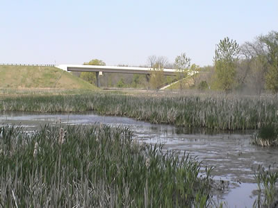
Coon Path, a pooled mitigation site designed and constructed
by Ohio DOT, transformed over 26 acres of previous farmlands
into wetland habitat and preserved approximately 19 acres of
forested upland buffer.
Program Contacts
William Cody
Asst. Env. Administrator
Office of Environmental Services
Ohio Department of Transportation
1980 West Broad Street
Columbus, OH 43223
Phone: 614-466-5198, Fax: 614-728-7368
Email: Bill.Cody@dot.state.oh.us
David Snyder
Env. Program Coordinator
FHWA-Ohio Division
200 North High Street, Room 328
Columbus, OH 43215-2408
Phone: 614-280-6852, Fax: 614-280-6876
Email: David.Snyder@fhwa.dot.gov
Program History and Philosophy
Of the States participating in the scan tour, Ohio is one of four (Texas, Pennsylvania and Kentucky being the others) that has four COE district offices with jurisdiction in the State. The lengthy process for establishing an MBRT and the arduous process of getting sites approved as mitigation bank sites are partly responsible for the Ohio Department of Transportation's (ODOT) preference for consolidated or pooled mitigation as opposed to banking. Consolidated mitigation is the construction of wetland mitigation areas in excess of permit requirements. The excess wetland area can then be used to offset impacts for other transportation projects. The use of the excess area as mitigation must still be approved by the COE and local regulatory authorities, but an MBRT is not used.
The term banking has a specific meaning in the State of Ohio. It is considered primarily a commercial enterprise designed to sell credits for a profit. The banking industry in Ohio is linked closely to the homebuilders industry, and private banking credits generally sell for $25-35,000. Although ODOT has and will continue to purchase credits from privately owned wetland mitigation banks, the department has found that it is more expedient to develop wetland mitigation outside the private banks. Furthermore, according to Ohio DOT, no new private banks are emerging in Ohio due to poor profit margins, rigorous criteria, and a cumbersome MBRT process.
Ohio DOT's first wetland mitigation site was constructed in June 1990 as compensatory mitigation for the U.S. Route 35 four-lane new location highway in Gallia County. At that time, Ohio DOT did not have a legal mechanism to utilize transportation funds to purchase property for the purpose of wetland mitigation and had to secure legislative authority to do so. Since then Ohio DOT has held legislative authority to utilize eminent domain for the acquisition of lands required for wetland mitigation (this does not apply to stream mitigation), although this legal authority has not been tested in court.
Moreover, financing the purchase of mitigation bank sites remains an ongoing problem for Ohio DOT, whose real estate and finance offices have a difficult time justifying the purchase of land for "credits only." While ODOT has and continues to use a debit/credit system for wetland mitigation, a debit/credit system that goes on for years prior to transportation project impacts is not well received by the accounting office. Thus, a full-scale banking program has been impractical to pursue for Ohio DOT. To date, ODOT has only one site that is being called a mitigation bank for wetlands (the permit is pending with the COE-Louisville District Office).
For more than a decade ODOT has been most successful at using consolidated sites (i.e., several projects are mitigated at the same location) and/or pooled sites (mitigation site is developed beyond the needs of a single project and extra credits are held for future use). Under this scenario, a compensatory wetland mitigation site proposal and implementation plan is included in the permit application package for a roadway project, and upon approval of the permit application (which can take 8 to 12 months), or through a separate mitigation agreement, the mitigation site is constructed simultaneously with the project construction. A combination of Federal and State dollars are used to finance the mitigation, which is usually considered a contract line item within a roadway construction project budget.
Ohio DOT has acquired some of its mitigation sites through fee-simple real estate as part of highway rights of way. However, the department prefers to implement compensatory wetland mitigation on sites already owned and operated by other entities such as Ohio DNR, local government agencies, and non-profit organizations. The department is experienced with using conservation easements or deed restrictions to secure such mitigation sites. Ohio DOT has not used in lieu fee mitigation as an alternative to banking. Overall, ODOT estimates that 60 percent of its wetland mitigation projects are developed as pooled mitigation and 40 percent as third-party banks. The third-party banks utilized by ODOT have been both entrepreneurial and public banks, of which the entrepreneurial banks have proven more successful because they are more numerous than public banks and located in more watersheds and available for use.
One of the greatest concerns presently for ODOT is the time lag between submitting a wetland mitigation plan (in the permit package) to the COE and getting the plan approved and "on the ground." As stated earlier, it can take up to one year for a permit approval, and with four COE district offices in the State, and 600 road projects per year, this can create a logistical quagmire. Ohio DOT has negotiated an agreement with the COE-Huntington District that would allow the department to fund five new COE positions in Columbus devoted exclusively to ODOT projects. The agreement is not intended to formalize performance measures per se, but rather to streamline the COE's input on transportation projects, particularly at the permitting stage.
Ohio DOT has successfully implemented many other streamlining measures. It funds State Historic Preservation Officer (SHPO), Ohio EPA, and USFWS positions, and is currently working on a programmatic agreement with USFWS for the Indiana bat, an endangered species that affects 99 percent of ODOT projects. Although ODOT has attempted a NEPA-404 merger, it has not been successful due to inter-agency differences regarding the designation of agency leads for concurrence points.
As Federal guidelines establish more firmly a watershed-based approach to wetland mitigation, ODOT perceives that the new COE positions will become an even more valuable streamlining asset to the department. Ohio DOT's wetland mitigation sites have HUC-8 service boundaries; however, ODOT does not currently integrate its mitigation plans with local watershed plans. The department communicates with local watershed groups, but there is no coordinated or comprehensive approach. The new COE positions can play an integral role in helping ODOT examine viable approaches for integrating its mitigation activities with watershed plans as they develop in the State.
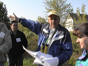
Ohio DOT ecological field studies team leader John Baird
(center) oversees the design, construction, and
post-construction monitoring of the department’s.
28 wetland mitigation sites.
Ohio EPA also has a significant role to play in this regard. In what is perhaps unique to the State of Ohio, Ohio EPA is investigating biological water quality standards (i.e., biocriteria) for wetlands and streams in an effort to establish biological criteria (not just chemical components) for overall ecosystem health. While this initiative is still in progress, its end result will expand the scientific knowledge related to wetland and stream mitigation on a watershed basis.
Like Alabama DOT, Ohio DOT has encountered difficulty in addressing stream mitigation. Ohio DOT is already doing stream mitigation and has determined that the most cost-effective and ecologically sound approach is preservation. While preservation is usually the last option considered for wetland mitigation, ODOT believes that it makes the most sense for stream mitigation because one cannot "create" a stream; one can only preserve or enhance it. Ohio DOT has found that it costs on average $3-10 per linear foot to preserve a stream, compared to $300 per linear foot to restore a stream. The regulatory agencies, however, have not expressed support for stream preservation in lieu of in-stream work. Ohio DOT is eager to see the Federal guidelines for implementing the Department of Defense's new stream mitigation rule required by Congress, and especially any sound science that is available to engineer the construction or restoration of streams.
In the meantime, Ohio DOT continues to build upon its successful consolidated and pooled wetland mitigation initiative. Although it is essentially "project-by-project," or rather multi-project, mitigation, it has proven to be a cost-effective and ecologically sound approach for a department that manages 600 road projects that impact less than 12 acres of wetlands annually. One additional factor that contributes favorably to ODOT's program is that the department's Office of Environmental Services (OES) has centralized oversight authority over wetland mitigation, including design, construction, and post-construction monitoring. OES employs a landscape architect and biologists with wetland experience to oversee all of the department's mitigation projects. With only one minor exception, no ODOT transportation project has been delayed to date due to insufficient mitigation.
Site Descriptions and Operations
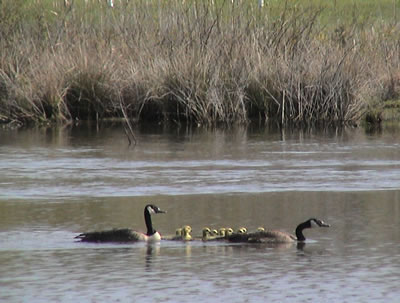
Canadian geese at Bluebird mitigation area.
Ohio's wetlands cover less than two percent of the State. Swamps, wet prairies, coastal and embayment marshes, peat lands, and wetlands along stream margins and backwaters are the most common Ohio wetlands. Wetland area in Ohio has declined by 90 percent during the last 200 years, from about 5,000,000 acres to about 483,000 acres. Drainage of wetlands for agriculture has been the primary cause of wetland loss, but recreational use, fluctuating water levels, urban development, mining, logging, and fire also have contributed. Ohio designates all remaining wetlands as State resource waters. As such, wetland water quality is protected from degradation that may interfere with designated uses. (9)
This history offers another justification for Ohio DOT's preference to build its mitigation sites on properties already owned by other parties. Large, contiguous tracts of quality wetland acreage are difficult to find, and in cases where ODOT must purchase land, build a site, monitor the site, and manage it in perpetuity, the department estimates that mitigation can cost up to $100,000 per acre. For construction costs alone (not including DOT personnel costs), ODOT estimates that it spends $40,000 for mitigation per wetland acre. This figure can range between $12,000 and $100,000 for commercially available mitigation.
Currently, Ohio DOT has established 28 wetland mitigation sites (of which only one is considered a "bank") on more than 268 acres, although acreage for three of the new mitigation sites has not yet been calculated.
The sites observed on the scan tour include the following:
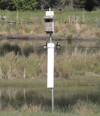
At the request of the community, bluebird boxes were
preserved on portions of the Bluebird wetland mitigation
site. The site is located on the Hoover Nature Preserve,
owned and managed by the City of Columbus.
- Bluebird Wetland Mitigation Area (7.6 wetland acres constructed; 7.6 acres used)
Located within ODOT District 6 in Delaware County, this site was constructed in 2000 on property owned and managed as a park (Hoover Nature Preserve) by the City of Columbus to mitigate for a portion of the wetland impacts associated with the FRA-161 New Albany Bypass Project. Originally a bluebird preserve, the site now contains three emergent wetland cells that were constructed in previously upland old fields (i.e., abandoned pasturelands or retired croplands elevated above bottomlands in a stage of plant growth between bare ground and forest) to closely integrate with, and enhance, the existing wetlands and pond located on the property.
- New Albany Wetland Conservation Area (13.68 wetland acres constructed; 13.68 acres used)
Located within ODOT District 6 in Franklin County, this site was constructed in 1996 to provide a combination of open water, emergent, and forested pool wetland habitats interspersed with upland buffer areas and existing forested wetlands to compensate for wetland impacts again associated with the FRA-161 New Albany Bypass Project. Vernal pools on site have become breeding areas for smallmouth salamanders and other amphibians, while the emergent and open water areas have become increasingly important habitat for flora and fauna diversity in a landscape that is quickly becoming urbanized.
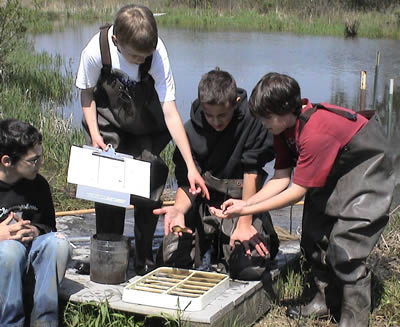
- Coon Path Wetland Mitigation Area (26.65 acres; 21.65 acres used to date)
Located within ODOT District 5 in Fairfield County, this site was constructed in 2002 as a pooled mitigation site to compensate for unavoidable impacts resulting from the Lancaster Bypass and Hill Diley Interchange projects. The site transformed over 26 acres of previous farmlands into wetland habitats and preserved approximately 19 acres of forested upland buffer. The site has been planted with over 32,500 container grown plants, 500 bare root stems, and 200 gallon-container size trees to develop a diverse community of aquatic bed, non-persistent emergent, emergent, and forested vegetation. The berms surrounding the four constructed wetland cells were drill seeded with a wildlife prairie seed mix to enhance the diversity of the vegetation and stabilize the berm soils. To date, 21.65 acres have been used, and ODOT plans to use the additional 5 acres to mitigate for future unavoidable impacts within the watershed.
Geographic Service Areas. All Ohio DOT pooled and consolidated mitigation sites have service areas negotiated with the COE and EPA through the 404/401 permitting process. The service area of the department's one mitigation bank will follow the eight-digit watershed hydrologic unit category (HUC-8) for Ohio. For on-site mitigation, sites must be located within one mile of the project or within the HUC-11 or HUC-14 watershed boundaries where the project occurs.
Functional Assessment Methodology. In Ohio mitigation ratios are tied to the quality of wetlands per category; whereas, other States tie the criteria to creation, restoration, enhancement, and preservation. Ohio EPA has established the general criteria for wetland mitigation standards to achieve no net loss in the State. Wetland types are defined as categories (1, 2, 3) with well-defined quality indicators. Category 1 wetlands are the lowest quality wetlands and require the lowest compensatory mitigation ratio. Category 3 wetlands are the highest quality and require higher mitigation ratios. Category 1 wetlands have mitigation ratios of 1.5:1 for non-forested and forested wetlands for both on-site and off-site mitigation projects. Category 2 wetlands have mitigation ratios of 1.5:1 for non-forested wetlands and 2:1 forested for on-site mitigation projects, and 2:1 non-forested and 2.5:1 forested for off-site mitigation. Category 3 wetlands have 2:1 non-forested and 2.5:1 forested for on-site mitigation, and 2.5:1 non-forested and 3:1 forested for off-site mitigation.
The specification, protection, and management of non-wetland buffers have played a minor role in Ohio DOT's program. Buffers are now required on all wetland mitigation projects. Wetland buffers increase the size of the site and, therefore, the cost to purchase the land as well as the costs associated with long-term management. Ohio DOT has received up to 0.25 acres of wetland mitigation credits for each acre of buffer on some mitigation sites. Buffer credits are determined on a case-by-case basis.
Like Alabama DOT, Ohio DOT receives credits for protecting endangered species on its wetland/stream mitigation sites, although States tend not to employ this measure as it may be considered "double counting."
Monitoring Protocols. Ohio DOT has developed a standardized monitoring protocol that includes two site visits per year for five years. Within the last two years, Ohio EPA has developed a new labor-intensive vegetative index of biotic integrity monitoring protocol for wetland mitigation sites. Ohio EPA has been making its use mandatory through the permitting process as a condition of the 401 certification. (When Ohio EPA completes its new biological criteria for water quality standards, it is anticipated that a similar monitoring protocol will be developed for measuring hydrologic conditions.) The new vegetative index specifies that mitigation sites will have no more than five percent cover of invasive plants species by the end of the monitoring period, although ODOT believes that a 20-percent cover may be a more practical standard. The discussions are ongoing regarding this point. Annual monitoring reports are provided to Ohio EPA and the COE. The reports provide information on the development of plant composition and cover, habitat development, hydrologic conditions, and wildlife use, and include photographic documentation of the sites. Discussions regarding the progress of the wetland's functionality as well as problems or corrective measures taken are also noted.
Accounting Procedures. Mitigation debits are defined through the 404/401 permitting process. Mitigation credits (acres) are tracked and tabulated for each mitigation site. When credits are utilized a mitigation balance sheet is submitted to the COE and Ohio EPA.
Maintenance and Management. During the operational life of Ohio DOT's wetland mitigation sites, the department finances all maintenance needs and corrective measures taken, and in some cases ODOT has provided maintenance fees for a site's long-term management. Ensuring that a mitigation site is first established with the best quality soil is a priority, and this involves utilizing sound techniques for establishing proper hydrology and successful seed plantings for specific soil types. Detecting and removing clay tiles previously installed for drainage of agricultural fields is a common site construction issue. Ohio DOT has also had success with using the Agri-DrainTM water control structures to manage hydrology on some of its sites.
For mitigation sites that will eventually be turned over to the original property owners to manage in perpetuity, Ohio DOT invests much time and effort in educating the future property managers on monitoring protocols. For example, at the Bluebird mitigation site, staff from the City of Columbus parks department routinely work side by side with ODOT biologists during field inspections, becoming well familiar with site features that need to be fostered, as well as those, such as plant invasives, that need to be carefully watched for and eradicated.
Students from New Albany Middle School show species obtained during a recent field inspection of the New Albany Wetland Conservation Area.
|
Students of New Albany Schools will become the “owners and perpetual managers” of Ohio DOT’s New Albany wetland mitigation site. |
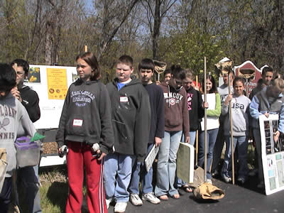
One of the most outstanding examples of Ohio DOT's community involvement is found in the New Albany Wetland Conservation Area. The site has become and important educational and recreational resource for the nearby New Albany High School and Middle School and the general public. During the site's monitoring phase, ODOT invited teachers and students from the schools' environmental sciences program to assist biologists with field inspections. To date, 3,000 students have used the site for educational purposes, and 180 students continue to use the site annually. Ohio DOT is currently in the process of transferring the deed to the school district, which has already won several national education awards recognizing the scientific and community partnership values associated with the wetland mitigation site. In addition, the school district successfully obtained transportation enhancement dollars to protect a threatened section of the upstream watershed for the mitigation site, securing 22,000 linear feet of greenbelt and saving more than four acres from housing development.
One approach to long-term management that Ohio DOT has not yet adopted involves turning over mitigation sites via deed transfers to land trusts. In the State of Ohio, few land trusts have demonstrated an established track record of land management. As a result, Ohio DOT does not have confidence that the sites turned over to the land trusts can be guaranteed protection in perpetuity. If a land trust fails and goes bankrupt, then the sustainability of the mitigation sites entrusted to them may fail as well. However, partnering with land trusts may become an important management strategy for future mitigation sites, and there is currently an initiative under way in the State to bring small land trusts together as a consortium to ensure the trusts' long-term viability.
Best Practices and Innovations
- ODOT is funding five COE employees in a new office in Columbus. The COE employees will be dedicated to ODOT projects statewide regardless of where the projects occur in Ohio's four COE district offices.
- While ODOT has been discouraged from establishing mitigation banks due to bureaucratic procedural difficulties, the consolidated mitigation sites represent a means of achieving multi-project mitigation and represent a cost savings compared with project-by-project mitigation.
- Ohio DOT's upper management is committed to providing the funding and expertise to develop effective quality wetland mitigation projects.
- The Ohio DOT OES employs both a landscape architect and biologists trained in wetland construction. This in-house team reviews all of Ohio DOT's wetland mitigation designs and monitors the projects during and after construction.
- ODOT seeks opportunities to build quality mitigation sites on lands already owned and managed into perpetuity by other agencies and organizations. The land purchase costs saved can be significant, and if necessary, redirected to researching and employing more innovative mitigation techniques to advance the science.
- Effective education, communication, and coordination are undertaken at all phases of a wetland mitigation project. Throughout wetland mitigation projects, OES staff educate engineers and construction personnel on the nuances of quality wetland development. This goes as far as affording OES staff the ability to make changes during construction to improve wetland performance.
- ODOT has turned over the land and monitoring requirements of one of its mitigation areas to a local school district. The monitoring reports are generated by middle school and high school students and submitted to the resource agencies.
Continuing Challenges
- The accounting office in ODOT is reluctant to provide funds for a wetland banking system that will provide mitigation for future impacts that may be years away.
- No new banks are emerging in Ohio due to the rigorous performance and monitoring criteria and a cumbersome MBRT process. This applies to both public and private banks. Poor profit margins also inhibit the development of new private banks.
- Even with consolidated mitigation sites, permit applications are taking about 12 months on average to process.
- ODOT mitigation sites are restricted to HUC-8 service areas. This may also partly explain the reluctance to develop mitigation banks.
- As in other States, stream mitigation has proved problematic. ODOT is eager to see Federal guidance implementing stream mitigation. ODOT believes that stream preservation is the best measure since engineering stream restoration is difficult. Furthermore, ODOT estimates it costs approximately $3-$10 per linear foot to preserve a stream compared with $300 per linear foot for stream restoration.
- Although DOT mitigation banks have proved quite successful in a number of States, the low annual impact of wetlands by ODOT statewide would not justify the expenditure for mitigation banking as required by the HUC-8 service area guidelines.
- Mitigation sites are constructed as a result of project impacts. The ecological success of the project-by-project mitigations is more uncertain than for functioning banks.
- The resource agencies have not been receptive to stream preservation as mitigation. ODOT believes this is the only truly effective stream mitigation to date, as stream restoration is perceived as difficult and costly.
- ODOT would like to see definitive Federal guidance on stream mitigation.
Back to top

