Texas
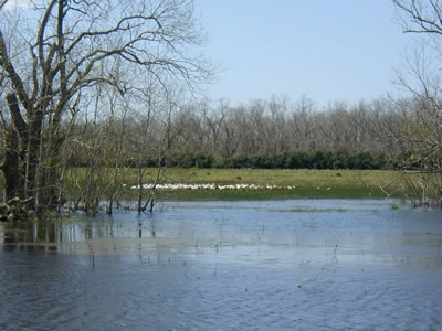
Coastal Bottomlands wetland mitigation bank in Brazoria
County, TX, includes compensation for bald eagle habitat.
Photo courtesy of Patricia Bacak-Clements, USFWS
Program Contacts
Duncan Stewart
Texas Department of Transportation
125 East 11th Street, Austin, Texas 78701
Phone: 512-416-3014, Fax: 512-416-2319
Email: dstewar@dot.state.tx.us
Tom Bruechert
FHWA-Texas Division
300 East 8th Street, Room 826
Austin, Texas 78701
Phone: 512-536-5948, Fax: 512-536-5990
Email: Tom.Bruechert@fhwa.dot.gov
Program History and Philosophy
The Texas Department of Transportation (TxDOT) launched its wetland banking program in 1992, three years prior to the publication of the Federal Guidance for the Establishment, Use and Operation of Mitigation Banks(6). The start of the TxDOT banking program, including the establishment of two of the department's three banks, also preceded the issuance of other Federal guidance that helped to clarify the use of wetland banks as compensatory mitigation for Federal-aid highway projects. The TxDOT mitigation banks were the first State-owned wetland banks in Texas. Like TxDOT, the State transportation departments that became early champions of wetland banking contributed much to the cause of environmental stewardship, although in doing so they faced notable technical and administrative challenges.
The catalyst for TxDOT's banking program was the department's growing concern about the economies of scale associated with performing project-by-project, on-site mitigation and the possibility of future project proposals impacting the on-site mitigation areas. Where the construction and maintenance of TxDOT highways and bridges led to unavoidable wetland impacts, the relocations of wetland impact sites were often not practical where a highway already existed, and on occasion the most logical sites to compensate for unavoidable wetland losses were not available within the right-of-way or nearby area (8). Wetland banking offered Texas a way to efficiently and effectively invest State funds in higher quality wetland acreage that offered multiple uses, such as long-term functioning ecological characteristics at a watershed level as well as increased opportunities for public recreation on State-owned and managed lands.
TxDOT's early pursuit of wetland banking underscored a statewide initiative to protect and preserve large tracts of wetland acreage, particularly bottomland hardwood forests and swamps. Texas has lost nearly one-half of its original wetlands as a result of agricultural conversions, overgrazing, urbanization, channelization, water-table declines, construction of navigation canals, and other causes. Wetlands currently cover about 7.6 million acres of Texas, approximately 4.4 percent of the State's area. The most extensive wetlands are the bottomland hardwood forests and swamps of East Texas; the marshes, swamps, and tidal flats of the coast; and the playa lakes of the High Plains. (9)
TxDOT bank sites are considered unique and vital natural resources by both the USFWS and the Texas Parks and Wildlife Department (TPWD) because the sites represent highly diverse wetland habitats located within unusually large, contiguous forested tracts. The very first TxDOT bank (Anderson Tract Mitigation Bank) was designated by USFWS as one of 14 Priority 1 sites of ecological concern in the State of Texas.
Accordingly, TxDOT has forged successful inter-agency partnerships to ensure the stability of the State-owned and managed bank sites. TPWD is identified in the banking agreements as the agency that has assumed complete ownership and long-term/perpetual management responsibilities for Anderson and Blue Elbow upon initial purchase. Twenty years after initial purchase of the Coastal Bottomlands, all of TxDOT's mitigation banks will be under TPWD ownership, and with regard to the credits that have not been debited to TxDOT projects, TxDOT retains the right to debit them until they are exhausted. For TxDOT, who purchased the sites and currently pays TPWD for site monitoring and maintenance over a 20-year period of operation (for Coastal Bottomlands only), the total financial investment for the first two mitigation banks has averaged a remarkable $400-$500 per acre for the Anderson and Blue Elbow banks (no operations and maintenance (O&M) money was agreed upon between TPWD and TxDOT); and $4,000-$5,000 per acre for the Coastal Bottomland Bank (includes O&M money for TPWD), TxDOT's third bank. This amount represents State dollars only. Although the banks are used to mitigate for Federal-aid highway projects, as a matter of practice, TxDOT has opted not to use Federal-aid dollars for advance compensatory mitigation; rather, State dollars are applied to this activity. Federal-aid dollars are reserved exclusively by TxDOT for highway construction.
Banking has proven to be a cost-effective and ecologically sound form of compensatory mitigation for TxDOT. The Texas State Legislature in FY 2003 approved in lieu fee mitigation for projects outside the service areas of the TxDOT wetland mitigation banks. The in lieu fee program has been used in the Dallas, Houston, and Yoakum TxDOT Districts. TxDOT is currently evaluating the effectiveness of this mitigation approach compared to banking.
Site Descriptions and Operation
TxDOT has financed a total of three multi-project wetland mitigation banks, located primarily in the eastern and coastal regions of the State. The Anderson Tract and Blue Elbow Swamp banks operate under independent memorandums of agreement that involve COE, USFWS, EPA, TPWD, and TxDOT. The Coastal Bottomlands bank operates under a separate, mitigation banking instrument developed through and approved by the State's MBRT. To date, all of the banks maintain a positive balance of available credits.
- Anderson Tract (2,242 acres; 2,200 credits approved) USFWS Priority 1 site
A highly diverse wetland complex of riverine habitats, oxbow lakes, and many bottomland forest communities. Located in the Tyler District in Smith County and adjacent to Little Sandy National Wildlife Refuge.
- Blue Elbow Swamp (3,343 acres; 2,841 credits approved)
A "national priority wetland" that comprises a complex of habitats including young to mature Cypress-Water Tupelo bottomland forest, isolated pine-oak upland, emergent marsh, and open water. Located in the Beaumont District in Orange County.
- Coastal Bottomlands (3,552 acres; 1,522 credits approved)
A bottomland hardwood forest including willow swamp within the ecosystem of the Gulf Coast Prairies and Marshes and within seven miles of the Peach Point Wildlife Management Area and San Bernard National Wildlife Refuge. Located in the Houston District in Brazoria County. Includes buffer area uplands with 500-year-old live oak trees (diameter breast height, or dbh, in excess of 200"). Also includes Endangered Species Act (ESA) compensation for bald eagle habitat in the form of nesting and foraging areas.
Geographic Service Areas. The geographic service areas (GSAs) for the Anderson Tract (large = 43-county area within the drainage basins listed below) and Blue Elbow Swamp (medium = 8-county area within the Beaumont District, within the drainage basins listed below) were defined on a watershed basis and negotiated between COE, TxDOT, and the resource agencies prior to the establishment of the MBRT in Texas. The service areas for the banks do not conform to hydrologic unit category (HUC) designations; they are generally larger than HUC-8 boundaries and fall within the State's 11 river basins. The GSA for the Anderson Tract encompasses highway projects within the Atlanta, Lufkin, Paris, and Tyler TxDOT Districts and within the COE Fort Worth District, and within the drainage basins of the Sabine River, Sulphur River, Cypress River, Angelina River, and Neches River. The GSA for the Blue Elbow Swamp encompasses highway projects within the TxDOT Beaumont District and within the boundaries of the COE Galveston District, and within the drainage basins of the Sabine, Neches, Trinity, and San Jacinto Rivers. The GSA for the Coastal Bottomlands mitigation bank (small = one county and partially within 7 adjacent counties within the Houston and Yoakum Districts as well as in the drainage basins listed below) was established under the guidance of the MBRT, and applies to projects within the drainage basins of the San Jacinto-Brazos Coastal Basin, Brazos Basin, Brazos-Colorado Coastal Basin, Colorado Basin, and within the boundaries of the COE Galveston District.
Functional Assessment Methodology. The COE and TxDOT agreed to and use best professional judgment, with MBRT concurrence, to assign a rating of high, medium, or low quality for wetlands at the individual impact sites. The functional assessment methodology used when agreement on impact site quality values cannot be reached to establish bank credits and to provide a framework for site monitoring and maintenance is the Wildlife Habitat Assessment Procedure (WHAP), developed by the TPWD. TxDOT mitigation banks are eligible for preservation, restoration, creation, and enhancement credits, although the sites are considered primarily preservation sites. The ratios used for preservation credits at Anderson Tract and Blue Elbow are 7:1, 5:1 and 3:1, for impacts to high, medium and low quality wetlands, respectively. The ratios used for preservation credits on the Coastal Bottomlands mitigation bank, the only TxDOT bank established under the guidance of an MBRT, are currently 6:1 acres for impacts to high qualitywetlands, 4:1 acres for impacts to medium qualitywetlands, and 2:1 acres for impacts to low qualitywetlands. For creation credits TxDOT receives a 1:1 ratio for 40 acres of open water and emergent marsh creation.
Monitoring Protocols. TxDOT and TPWD (along with other agencies) developed a baseline WHAP score when the banks were first established. TPWD will continue to monitor the sites using WHAP. The sites consist mostly of bottomland hardwood forests that do not reach ecological maturity for decades (a 20-year lifespan for each of the banks was the intended goal for when all credits would be debited). The TPWD uses the WHAP framework to document each site's functional level, biological lift or decline, and to help determine how to best implement the management plan to increase function and value of the wetland sites. One point noted by the scan team was that the WHAP is a wildlife habitat assessment approach only, and does not deal with other wetlands functions, such as water quality or surface water storage. This has led to an imbalance in crediting debiting ratios, since the Coastal Bottomlands bank, for example, is serving significant water storage and water quality functions.
Accounting Procedures. In accordance with its banking agreements, TxDOT maintains a ledger of credits and debits that documents the activity of the mitigation bank project accounts. The initial record includes a map of the project area showing the status of the water of the United States and non-water of the United States credits, including valuable uplands. Debits are recorded in the ledger at the point at which approval is received from the COE that credits from the project may be used as compensatory mitigation for unavoidable adverse impacts from a particular TxDOT project. The debits are recorded by: (1) COE project or permit number, (2) transaction date, (3) number of credits approved for use, (4) TxDOT project information, and (5) type of habitat impacted. TxDOT also uses the ledgers to record debits from the mitigation bank project as a result of impacts from human development such as oil and gas exploration. A statement of account is provided annually to the MBRT (for the Coastal Bottomlands) and signatories of the MOA (for the Anderson Tract and Blue Elbow Swamp).
In the case of the Coastal Bottomlands mitigation bank, two ledgers of credits and debits are maintained: one for preservation credits at a 2:1, 4:1, and 6:1 debt ratio, and one for credits resulting from the creation of emergent wetlands and restoration of bottomland hardwood wetlands at a 1:1 ratio.
Maintenance and Management Concerns. All three bank sites are currently operating and are under TPWD management. As a result, TxDOT and TPWD were able to articulate many of the challenges associated with the sites' long-term maintenance and management. Feral hogs have presented some cause for concern at the mitigation bank sites due to the destruction they inflict on seedlings and emergent vegetation. Exotic and invasive plant species, however, pose the most significant maintenance problem, particularly in the Coastal Bottomlands and Blue Elbow Swamp mitigation banks. Both sites were previously disturbed by logging activities. This enabled the introduction of numerous noxious plant species, of which the most difficult to manage has been the Chinese tallow tree. TxDOT uses prescribed burning periodically on grassland areas to help control this invasive and is currently sponsoring research with Texas A&M University to identify and implement other weed control mechanisms.
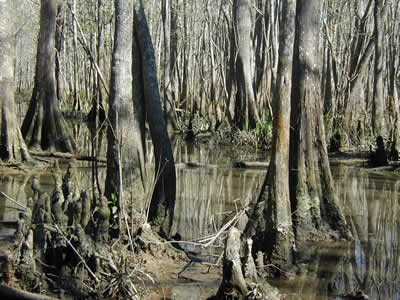
Blue Elbow Swamp mitigation bank in Orange County, TX, is a
“national priority wetland.”
The two mitigation banks are also affected by vandalism and littering. In the case of Blue Elbow Swamp, prison labor is often utilized to help clean the site and repair damage caused by vandals. Although all three sites are open to the public for recreational activities, such as hiking, fishing, and hunting - which, in fact, is considered a highly valued feature of these sites for the State of Texas - the Coastal Bottomlands and Blue Elbow Swamp bank sites were formerly private lands not well secured and frequently disturbed by trespassing; thus, the enforcement of properpublic and recreational use of the lands has become an evolving management issue for TPWD. The Anderson Tract mitigation bank, while also formerly private lands, runs contiguous to the Little Sandy National Wildlife Refuge, which has been long-managed by TPWD for both its wildlife habitat and public recreational uses. Due to this ideal location, the site and forest cover have been relatively undisturbed. Thus, vandalism and littering have not been prevalent management issues for this site, nor has exotic or invasive plant species.
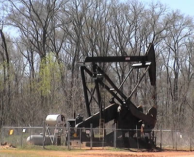
Oil pump station on Anderson Tract
The Anderson Tract mitigation bank includes important mineral resources under third-party ownership, and an oil pump station is located on site. According to the memorandum of agreement,
"exploration and development of these minerals is acceptable under the MOA provided that surface alterations are the minimum necessary to accomplish the intended purpose, activities are conducted to minimize adverse environmental impacts, impacted areas are restored to pre-existing conditions as soon as practicable after the surface alteration is no longer needed, and the number of credits available for use in the account is reduced by the number of acres adversely impacted by the activity."
The MOA also requires the development of a mineral management plan as a component of the overall strategic management plan for the mitigation bank. (8)
One additional management issue that TPWD brought to the scan team's attention, and that is currently not addressed in the banking agreements, pertains to regional economic growth and water resource needs. The State of Texas is experiencing unprecedented population growth, which is expected to place significant increased demands on the State's water supplies. Five new reservoirs are planned, and the TxDOT mitigation banks, as State-owned properties, are not necessarily invulnerable to "reassignment" by the State Legislature for the purpose of supporting the State's growing water supply demands. This raises the important, and as of yet unresolved, long-term management issue of how to mitigate for a mitigation bank site if public need warrants unanticipated use of the bank.
Best Practices and Innovations
- Using a third party (e.g., TPWD) to maintain and manage a mitigation bank site is a prudent strategy. Transportation departments lack the human resources and/or technical expertise required for long-term management of bank sites.
- Allowing public recreational use of a site can significantly enhance the value of a State-owned mitigation bank (although it can also significantly add to the cost of its maintenance), as long as the prescribed public use does not compromise the ecological integrity of the site or the credits that TxDOT is trying to use/enhance.
Continuing Challenges
- Exotic and invasive plants seem to be especially prevalent on mitigation sites previously disturbed by commercial activity, such as farming and logging.
- Mining and use of mineral rights within TxDOT mitigation banks must be addressed within the banking instruments. The implications of managing a bank site in perpetuity must be taken into account for those banks that include third-party mineral rights or that are located in high-growth regions with water supply challenges.
- Texas only uses Federal-aid highway funds for construction and right-of-way acquisition. They have not used Federal-aid highway funds to acquire any of the banks, or for management and monitoring.
Back to top

