Disclaimer for References to Greenhouse Gas in this document:
On January 20, 2025, President Trump signed Executive Order (E.O.) 14148 --Initial Rescissions of Harmful Executive Orders and Actions and E.O. 14154 – Unleashing American Energy. The E.O.s revoked E.O. 13990 – Protecting Public Health and the Environment and Restoring Science to Tackle the Climate Crisis (January 20, 2021) and E.O. 14008 – Tackling the Climate Crisis at Home and Abroad (January 27, 2021). Subsequently on January 29, 2025, Secretary Duffy signed a Memorandum for Secretarial Offices and Heads of Operating Administrations – Implementation of Executive Orders Addressing Energy, Climate Change, Diversity, and Gender. On February 25, 2025, the Council on Environmental Quality (CEQ) published an Interim Final Rule removing the CEQ’s National Environmental Policy Act (NEPA) implementing regulations, effective April 11, 2025 (90 Fed. Reg. 10610). As a result of these actions, FHWA will not include greenhouse gas emissions and climate change analyses in the federal environmental review process. Any purported greenhouse gas emissions and climate change impacts will not be considered in the federal decision.
Ecosystem and Vegetation Management
VEGETATION MANAGEMENT: An Ecoregional Approach
View PDF (14 MB)
Edited by
Bonnie Harper-Lore, retired FHWA Restoration Ecologist
Maggie Johnson, EPA Botanist
William F. Ostrum, FHWA Environmental Specialist
CONTENTS
FOREWARD
When we first started using an “ecoregional approach” to roadside vegetation management, we received an inquiry from a newspaper in the Minneapolis-St.
Paul area. They wanted to know why we weren’t mowing and spraying more (or all) of the non-paved areas of the transportation corridors. Our response was
that roadsides fit the definition of rangelands or grasslands, even where largely wooded. The roadsides are not agricultural lands, manicured lawns nor
parklands. Rangelands are mainly managed by applying ecological principles to the development and manipulation of the vegetation. An ecological approach
required a longer time frame to produce favorable results. A newspaper responded that it sounded good but seemed to be just another name for “don’t
mow the grass and let the weeds grow.” And so it often may appear at first. Time is an important element in the development of things in nature.
Starting from zero in 1900, independent motorized vehicles (cars and trucks) increased so rapidly that by about 1930 there was one car for every six citizens
(today there is more than one per citizen). Highway structures had to increase accordingly and became the “Arteries of the Nation.” They are
the most widespread and visible of all public improvements. In 1932, the Roadside Development Committee in the Design Division of the Highway Research
Board was established to research and disseminate information regarding roadside care and use (termed “development”). Later there was a Committee
on Roadside Maintenance in the Maintenance Division. In time, the American Association of State Highway Officials (AASHO) formed a somewhat parallel committee
to exchange information on the subject between the States. In the late 1960’s, the AASHO committee was re-established in a different form and name.
With the “Great Depression” in the 1930’s, highway work projects of the Works Project Administration (WPA) employed many architects and landscape
architects. It was natural that a “dressed-manicured” agronomic approach should result. The term “front yards of the nation” came
into vogue. This carried with it the image of front lawns, fairways and parkways (as per the Washington and Taconic Parkways) developed at that time.
The agronomic approach was in the forefront.
With the start of the Interstate highway program, late 1950’s, early 1960’s, the acreage involved rapidly increased and so did soil erosion and costs.
By the late 1960’s roadside policy modifications became common - “limited contours” and “architectural mowing” and spot spraying
are examples. Then in the 1970’s came the fuel shortages and cost inflation to increase the mood for change. Applications of the ecological approach were
showing results and gaining public acceptance.
The transportation structure exists between the two right-of-way boundaries. Its primary purpose is to provide a safe, smooth, solid surfaced area to
move vehicles on efficiently. All other concerns are secondary or less. Thus the main purpose of the non-surfaced areas i.e., fore slope, ditch, back
slope and other vegetated areas - is to provide stability to and protection for the surfaced areas from damage or traffic interruption. The ecological
approach is a naturally stabilizing approach for vegetation whereas the agronomic approach is a disturbing approach (mowing, broadcast spraying with the
negative effects of the accompanying power equipment).
The two approaches, ecological and agronomic, require a differing set of inputs. the ecological approach mainly requires research and planning with some
minor material, equipment and financial inputs such as seed, spot spraying and limited mowing. The agronomic, approach required large inputs of equipment,
materials, manpower, fuel and finances. the agronomic approach has quick, short-lasting results (a freshly-mowed area, for example). Because of the disturbance
resulting to vegetation from the mowing, spraying, etc. the results are short-lived and must be repeated regularly. Damage from the equipment (wheel tracks,
etc.) is longer lasting. The results of the ecological approach are considerably slower from decreased disturbance, and increased vegetation stability
is large. Secondary dividends are increased habitat for small non-game and game wildlife, refuges for native plant species and often a pleasing visual
appearance. Some call it “naturalization of the roadside”.
Lawrence E. Foote, Ph.D.
retired, Minnesota Department of Transportation
Back to top
ACKNOWLEDGEMENTS
Vegetation Management: An Ecoregional Approach is the third book in a series intended to provide support for the on-the-ground individuals of State Departments
of Transportation (DOT) and other land managers as partners. Once again we called upon many scientists and practitioners to help us fill in the blanks.
State DOTs’ help was given by Jeff Caster (prescribed burn and outdoor advertising), Kenneth Graeve (native seed mix), Tina Markesson (bio-control use),
James Merriman (protection of pollinators), Art Thompson (the Nebraska model), and Ray Willard (corridor functional zone graphic). State Departments of
Natural Resources and their Natural Heritage Programs provided the ecoregion maps and visitable sites. Carmelita Nelson from the Minnesota DNR contributed
greatly to the section on road-sides for wildlife.
Coincidentally a National Cooperative Highway Research Program 14-16 project with the Transportation Research Board overlapped this work in 2009. We thank
Ian Heap, lead investigator on that team, for sharing the specific weed controls for 40 species of common invasive plants, often found on noxious weed
lists. Another research project is reflected in the section on GPS use in inventory work. Thanks to Victor Maddox of Mississippi State University for
the applied research and the training manual we hope all States will utilize.
Thanks to the support of the Federal Highway Administration’s Divisions and Resource Centers’ review of the classroom exercises. They are in perfect position
between Washington D.C. headquarters and the work on the ground, to review applications of this training manual. A very special thanks to our Natural
Environment teammates who reviewed information on the Migratory Bird Act, erosion and sediment control, wildlife habitat, along with roadside vegetation
and deer-crashes.
Our respect and appreciation go to Kirk Henderson of the National Center for Roadside Vegetation in Cedar Falls, Iowa, for his input into Part 3: Native
Plant Establishment. The Iowa experience with native plantings, expanding production of native ecotype seed and natural selection, along with the legislated
Iowa Living Roadside Trust accomplishments, should be a model to all States.
Including the foreword by Dr. Lawrence Foote is a great honor. He foresaw the potential for conservation and restoration of corridors. Our thanks for
his contribution.
We also thank Maggie Johnson (USEPA, Office of Chemical Safety and Pollution Prevention (OCSPP) at headquarters in Washington, DC) for her diligent and
meticulous work. Without Maggie’s communications with all 50 state Natural Heritage Programs, this unique collection of ecoregion maps would not exist.
And I thank Gary Lore for his unpaid editing time. No one does it better!
Bonnie L. Harper-Lore
Restoration Ecologist
retired, FHWA
Back to top
INTRODUCTION
Highway corridors connect us all via our commercial transport, recreational excursions, workday travel, and more. The mobility and safety of U.S. highways
is a proud accomplishment of the Federal Highway Administration with its State and local partners. Highway rights-of-way are the most visible of all public
lands and likely the least understood. This manual is especially written for those decision-makers in maintenance, landscape, environmental services,
and turf and erosion control to share what we know about managing this land.
The world of roadside management is complicated. Environmental regulations limit the practices we use. Utility lines, signage, fiberoptic and oil pipelines,
snow storage, adjacent crops, trout streams, and rangelands further limit our solutions. Daily weather conditions require changes on the fly. Public expectation
can change everything. Roadside development and maintenance have evolved far beyond the simple mow and spray or agricultural approach of the 1930s and
’40s.
In 1932, the Highway Research Board and American Association of State Highway Officials began the Committee on Roadside Development. The Bureau of Public
Roads (now the Federal Highway Administration) helped inspire a nation-wide interest in roadsides. Within this Committee were research groups on Erosion,
Plant Ecology, Public Relations and Roadside Economics. They reported, “The roadsides are but the frame of a continuous panorama landscape and as
such their development must be devoid of artificial effects and replete with natural settings.” The Plant Ecology sub-committee reported, “That
in each region, existing vegetation along a highway furnishes the key to proper selection of the trees and ground cover plants to be established.”
Why did this 1930s understanding of roadsides and the natural environment not continue? This question has no easy answer. It likely involves a combination
of factors: the economy, war, building of the interstate system, increased regulations, and a view of roadsides as extra real estate for further expansion
of infrastructure. Whatever the reasons, more roads meant more development and more disturbance of the environment. Application of ecological principles
to roadsides was not a priority.
In the 1970s, during the energy crunch, some DOTs and land management agencies in need of economic solutions moved away from the traditional agricultural
approach. The needs of public lands were not the same as those of a farm field. Using the local natural plant life found as part of the context of the
project once again made sense. It was during this era that some embraced reduced mowing of roadsides to reduce the use of costly fuels. Using the inexpensive
tool of fire to manage native remnants and native plants reduced costs as well. Preserving remnant native vegetation was preferred, because it was cheaper
and required less energy than seeding newly disturbed soils. Pragmatism shifted practices on the ground. This shift to an ecological approach resulted
in less surface water runoff, increased native seed source, more diversity and improved aesthetics.
In the 21st century, many land managers have fallen back to the reliable and quick solutions that are reminiscent of the agricultural approach. But the
conditions of our economy, the highway’s purpose, and the environment have changed again. We have another energy crunch, an explosion of weed invasions,
and global climate change. We knew an ecological approach held promise in the ’30s. We learned out of necessity in the ’70s that an ecological approach
works. Now we need to adapt our increased knowledge of ecology to current conditions with an eye to the future.
Back to top
PART 1
WHY AN ECOREGIONAL APPROACH?
INTRODUCTION
Community ecology is the study of biotic communities, “A biotic community is composed of all the organisms of all species living in a particular
area.” (Emmel, 1973)
It should not be news that the traditional practices borrowed from agriculture have not succeeded over time. The production goals of farmers and ranchers
differ from environmental stewardship goals of public land managers. Environmental stewardship remains an overall goal of highway design, construction
and management. To minimize impacts and do no harm has been the public mantra since the 1969 National Environmental Policy Act (NEPA). During the1970’s
economic crisis, when fuel costs skyrocketed to $1.25/gal, some State Departments of Transportation looked to the science of ecology for answers.
An ecological approach was discussed coast to coast, but not embraced by all.
Forty years later, while still trying to do the right thing, we are once again stressed by an economic crisis, higher fuel costs, and climate change considerations.
It is time for all land managers to reconsider an ecological approach.
Reference Cited:
Emmel, Thomas C. 1973. An Introduction to Ecology & Population Biology. W.W. Norton & Company, Inc. New York.
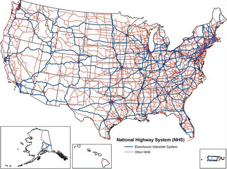
The National Highway System illustrates how highway corridors cross through and potentially impact our biotic communities. As a consequence, shared environmental
stewardship with transportation is key to protecting all lands.
Back to top
CHAPTER 1
ECOLOGY
Ecology is the study of the interrelationships of organisms and their environments, with the stress on interrelationships. One familiar teaching example
is to think of the environment as a giant, stretched-out fish net. If you pull on one part of the net, the entire net will move in response. Just like
that net, the components of our environment, living and not living, are connected. It’s not enough to know what habitats and species exist in the area
you manage. You must know how they relate to one another so that you can successfully manage a roadside habitat.
Why is Ecology Important to Roadside Vegetation Managers?
Humans alter landscapes for our own uses. Historically environmental and ecological impacts were not considered when land use projects were planned. We
have learned that these actions have definite significant impacts, and that it is more cost effective to plan to minimize impacts and ensure that ecological
integrity is retained than to abandon an area and find a new alternative or restore a severely impacted area.
Using an ecological approach to land management is valuable because, plain and simple, it works and saves resources in the long run. In order to properly
manage a roadside habitat and minimize damage so that the ecosystem will continue to function properly, it is critical to understand what makes up the
ecosystem (plant and animal species, soils, water, weather, etc.), how the ecosystem works, what the limiting factors are, and how much impact it will
withstand while still retaining its integrity as a functioning ecosystem.
Understanding Critical Ecological Principles
In 2000, the Land Use Initiative of the Ecological Society of America put together a White Paper entitled “Ecological Principles and Guidelines
for Managing the Use of Land” (ESA 2000). The document identifies five ecological principles or concepts that are important for land managers to
understand so that they can manage an ecosystem for human uses and still retain the integrity of the ecosystem.
The five principles are time, species, place, disturbance, and landscape. For greater detail on the five principles and especially on the guidelines (which
we will only list here) please refer to the original source at Ecological Principles and Guidelines for Managing the Use of Land by V. H. Dale,
S. Brown, R. A. Haeuber, N. T. Hobbs, N. Huntly, R. J. Naiman, W. E. Riebsame, M. G. Turner and T. J. Valone. Ecological Applications Vol. 10, No. 3 (Jun.,
2000), pp. 639-670. Published by: Ecological Society of America. http://www.jstor.org/stable/2641032
TIME Ecosystems function at many time scales, from the very long (geologic weathering of rock to form soil) to the very short (metabolic
processes within a plant or animal). Ecosystems can change over time, and left alone, the natural pattern of plant succession will take a disturbed roadside
Right-Of-Way (ROW) to a relatively stable plant community which will vary depending on regional conditions.
SPECIES It is important to understand the species of plants and animals present in the ecosystem because these species often have complex
interdependencies. A butterfly relies on a plant species to survive. Remove the plant and the butterfly will be gone too. What species are native to the
area and what introduced alien species are threatening the area? Retain and/or restore the native species if at all possible.
PLACE This principle stresses the importance of understanding the unique characteristics of the specific habitat. What are the plant
and animal organisms present, the soil types, water regime, prevailing climate, and geomorphology (slope, orientation, etc.) that characterize the habitat?
Any land management project must consider these specific characteristics because the species that will be established (or maintained) in the habitat must
be able to survive within these constraints.
DISTURBANCE Disturbance of a habitat is the result of natural events, such as wildfires or floods, or human activities, including clearing
native vegetation for agriculture or logging, building transportation systems, or controlling rivers via damming or levees. The type of disturbance will
affect the plant and animal populations that become established after the disturbance.
LANDSCAPE The size, shape, and spatial relationships of the land-cover types (forest edge, grassland, etc.) present will control the
types of plants and animals that can exist in the habitat. Generally larger habitats support a wider range of species and are more stable than smaller
habitats with fewer species. However, small, patchy habitats also can be valuable.
Guidelines for Decision-Making in Land Use Planning
The Land Use Initiative of the ESA used the five ecological principles described above to develop eight land use guidelines to assist managers in planning
roadside vegetation projects. Following these guidelines can help ensure that projects will maintain the integrity of the impacted habitat while still
serving the intended human needs. We will only list the guide lines here and suggest the reader refer to the original source for the specifics of the
guidelines.
- Examine impacts of local decisions in a regional context;
- Plan for long-term change and unexpected events;
- Preserve rare landscape elements and associated species;
- Avoid land uses that deplete natural resources over a broad area;
- Retain large contiguous or connected areas that contain critical habitats;
- Minimize the introduction and spread of nonnative species;
- Avoid or compensate for effects of development on ecological processes; and
- Implement land use and management-practices that are compatible with the natural potential of the area.
Back to top
CHAPTER 2
ECOREGIONS
An “Ecoregion” is a conceptual tool used by environmental managers in which landscapes are grouped into units and subunits by their ecologically-relevant
characteristics. The US EPA’s Western Ecology Division (https://www.epa.gov/eco-research/ecoregions)
describes ecoregions as areas of the landscape that have generally similar characteristics such as landforms, soils, hydrologic resources, and plants
and animals.
How Can an Ecoregional Concept Be Useful to Land Managers?
Ecoregions provide a way for land managers to manage and monitor ecosystems more efficiently. Just as the physical and biological resources within an
ecoregion can be described with some degree of confidence, the responses of that ecoregion to disturbances can be predicted. This aspect of predictability
allows for more efficient management!
Federal Agencies Use Various Ecoregional Approaches
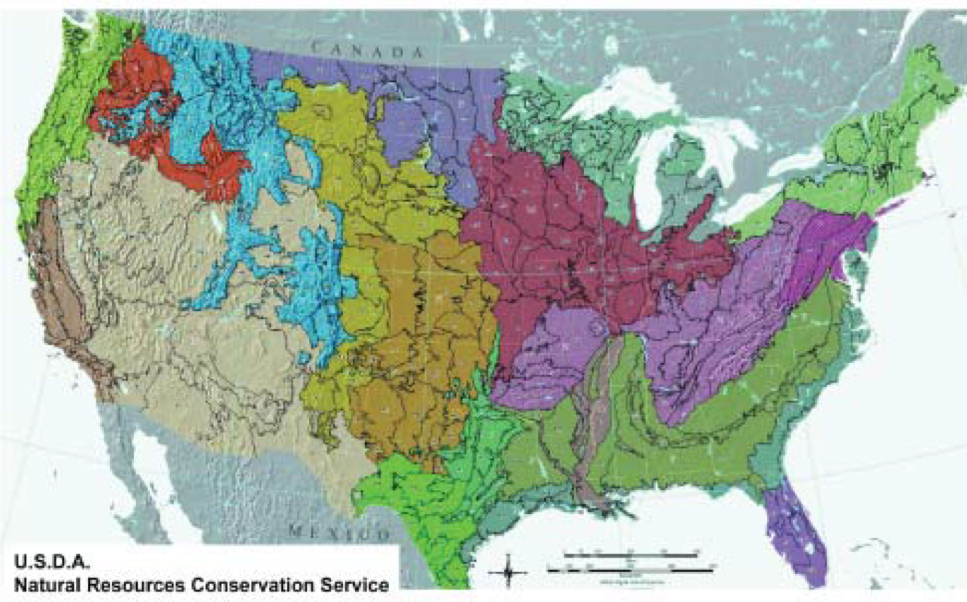
There are several major ecoregional classification systems developed and used by Federal land management agencies in the United States. These classifications
are similar in their basic concepts, but differ in their environmental focus. These ecoregional classification systems, include (1) the U.S. Department
of Agriculture (USDA) Natural Resources Conservation Service (NRCS) Major Land Resource Areas; (2) USDA Forest Service / Robert Bailey Ecoregions; and
(3) USEPA / James Omernik Ecogegions. This handbook- does not recommend any one classification system over another. One system is not “better”
or “preferred” - it’s up to the users to determine which system best fits their needs.
WHAT ARE PLANT COMMUNITIES AND WHY ARE THEY IMPORTANT?
The landscape is more complex than just forests, grasslands, and wetlands. Within any ecosystem, province, or natural region are local assemblages of
species known as plant communities. Collectively, these plant communities are called vegetation. Vegetation differs in kinds of species and total number
of species depending on the local soil and moisture conditions. Although plant communities differ from region to region, they have great similarities
in composition and structure. A mesic prairie in Wisconsin does not differ greatly from a mesic grassland in Kansas, and a lowland forest in West Virginia
is very similar to a lowland forest in Missouri. Understanding plant communities allows us to share solutions to road-side issues across the country.
No State, with the exception of Hawaii, has discreet plant communities.
Continued reaction to change of environment is favorable to some species and unfavorable to others. Drought, soil disturbances, and insect infestations,
will cause the species assemblage to change. In the past, these changes have been predictable. This change over time is known as succession. Succession
is the natural adaptation of plant species to changes.
Back to top
CHAPTER 3
USDA, NRCS Major Land Resource Areas - Soil Focused
One of the earliest ecoregional classification systems is the Major Land Resource Areas (MLRAs), first developed in the early 1970s by the U.S. Department
of Agriculture’s Soil Conservation Service (now the Natural Resources Conservation Service (NRCS)). This classification system has an agricultural focus
and as a result, the major defining characteristics are soils, climate, water resources, and land use patterns. There are 278 major land resource areas
which are further divided into geographically associated land resource units (LRUs). These LRUs generally correspond to the individual state general soil
map units.
The NRCS uses this system, described in the Agriculture Handbook 296 (USDA 2006), to assist in making national and regional land use decisions, identifying
research and inventory needs, and extrapolating research results across political boundaries. MLRA maps data for the entire United States, the Caribbean,
and the Pacific Basin, are available on the USDA web site at https://www.nrcs.usda.gov/wps/portal/nrcs/main/soils/survey/
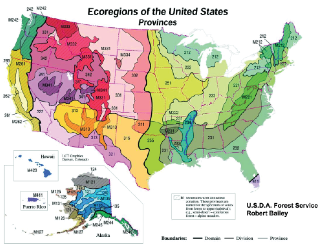
USDA Forest Service / Robert Bailey Ecoregions - Climate Focused
To address the needs of the United States Forest Service, in 1983 Robert Bailey developed an ecoregional classification based on climate, land surface
features (physiography), and potential natural vegetation (based on Kuchler (1964)). There are four levels of detail in Bailey’s ecosystem classification
- Domain, Division, Province, and Section. The geographically largest units are Domains, which are subdivided into Divisions.
Areas within a Division have similar overall climates but are subdivided by precipitation and temperature. Divisions are further subdivided into Provinces,
which are similar in vegetation cover types.
Maps can be downloaded at https://www.fs.usda.gov/rmrs/ecoregions-united-states. -content is no longer available)
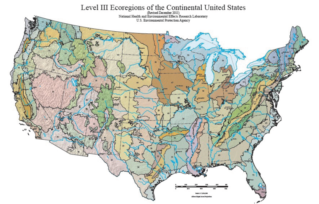
USEPA / James Omernik - Aquatic Ecosystem Focused
James Omernik (1995) describes the earliest attempts in the 1980s by the Environmental Protection Agency (EPA) to classify aquatic resources by adapting
Bailey’s (1976) ecoregional classification system. It is logical that streams in an ecosystem reflect the characteristics of the watershed, that they
drain, and because Bailey’s classification includes many characteristics critical to a watershed, that classification system was a logical starting point.
However, Bailey’s system was not a perfect fit for classifying aquatic ecosystems. EPA developed its own classification system based on their own needs
to classify aquatic ecosystems. The EPA/Omernik classification system is based on the belief that ecoregions are distinct by virtue of spatial variations
of many characteristics, and the predominant characteristics vary from one ecoregion to another. EPA/Omernik’s system gives numbers (Roman numerals),
not names, to the ecosystem levels such that Level I is the most general, Level II is a subdivision of Level I with Level III being the most detailed
level.
After the most general ecosystem classification (Level I) was published in 1987, various States, EPA Regions and Research Labs decided they needed greater detail for their management and research purposes. Cooperative efforts began to develop higher level maps. The Level III map was revised in December 2011 and is available at https://www.epa.gov/eco-research/level-iii-and-iv-ecoregions-epa-region. Level
IV maps are being developed and are available at https://www.epa.gov/eco-research/level-iii-and-iv-ecoregions-epa-region.
References Cited:
Bailey, R.G. 1983. Delineation of Ecosystem Regions. Environmental Management 7(4):365-373.
Küchler, A.W. 1964. Potential natural vegetation of the conterminous United States. American Geographic Society Special Publication 36. 116 p.
Omernik, J.M. 1987. Map Supplement: Ecoregions of the Conterminous United States. Annals of the Association of American Geographers, Vol. 77, No. 1 (Mar., 1987), pp.118-125 (article consists of 24 pages).
Omernik, J.M. 1995. Ecoregions: A spatial framework for environmental management. In: Biological Assessment and Criteria: Tools for Water Resource Planning and Decision Making. Davis, W.S. and T.P. Simon (eds.) Lewis Publishers, Boca Raton, FL. pp. 49-62.
USDA. 2006. Major Land Resource Area (MLRA) Land Resource Regions and Major Land Resource Areas of the United States, the Caribbean, and the Pacific Basin. U.S. Department of Agriculture, Handbook 296, Natural Resources Conservation Service(NRSC).
A Practical Application for Seed/Plant Species Choices
The Native Seed Network (NSN) is a program of the Institute for Applied Ecology (http://appliedeco.org/), a non-profit
organization located in Corvallis, Oregon.
The NSN works to provide resources and tools for habitat restoration efforts, and strongly encourages using native plant materials and local-area seed
sources. Their web site has a useful tool for selecting native plant species and seed sources based on the ecoregion where the project is located. The
NSN web site also offers an ecoregion map, based on the USEPA / Omernik ecosystem, which allows a site visitor to click on his or her State and retrieve
a native plant list by city or the specific subregion. Native plant information is from the PLANTS database of the NRCS at
http://plants.usda.gov/.
This type of application can be highly valuable to a land manager who may not have a strong background in ecology or botany but has to plan a revegetation
of habitat restoration project. The user can go to one web site and be directed to the proper ecoregion and subregion and then get a plant list specifically
for that subregion.
Back to top
PART 2
STATE ECOREGION MAPS, MODELS, AND RESOURCES
Introduction
HOW TO USE AN ECOREGION MAP FOR DECISION-MAKING
Transportation professionals have talked about an “Ecological Approach to Roadside Planting”, since 1941, when G.B. Gordon described it at
the legendary annual Ohio Short Course. This event took place annually from 1941-1966 and examined roadside development issues. Weed Control by Chemical
Treatment was discussed in 1946. Grasses, An Economical Approach to Erosion Control was described in 1953.
Half a century later, we continue to look for ecological and economical answers. This book includes “how-tos” for many of the land management
issues we continue to have in common. It also includes an ecoregion map for each State’s reference. Here are suggested steps for using the resources included
in Part 2 for your specific State:
- Look at your State’s map to get the lay of the land or big picture.
- Identify the natural region or ecological landscape in which your project is in located.
- Contact your State’s Natural Heritage Program (also shown) to find a preserve or natural example typical of that region.
- Visit the preserve or natural area to better understand the plant communities and species that are common there. Observe how they are structured and where
plants grow best. What grows in the wet areas that match your ditches? What grows in the driest parts that match slopes?
- Ask the Natural Heritage Program for a plant inventory list of the preserve to get correct common and scientific names to avoid mistakes in specifications
later. This natural area becomes your model or reference site for the plantings you do. It will allow you a benchmark for comparison over time to learn
what worked and what did not.
EXAMPLE:
A project is just north of LaCrosse, Wisconsin. Look at the map on page 122 to find the surrounding natural region is called the “Western Coulee
and Ridges”. Call the listed contact and ask for a location to visit and also ask for a plant inventory list for note making on site visit.
VISIT A PRESERVE
The Nature Conservancy (TNC) manages preserves in all 50 States and in more than 30 countries. These protected lands include some of the best remnants
of plant communities of grasslands, wetlands and woodlands for your information. TNC is the leading conservation organization working to protect ecologically
important lands and waters for nature and people.
Locate and visit a preserve near you to see adapted native plant associations to inform your own project site decisions. Use the preserves inventory list
as your shopping list to match plant species to your planting project. To access TNC preserve data as a source for Google Maps, or as a layer for Google
Earth (example below), you can use their feed url http://my.nature.org/preserves/.
Back to top
50 STATE ECOREGION MAPS, MODELS, AND RESOURCES
ALABAMA ECOREGIONS
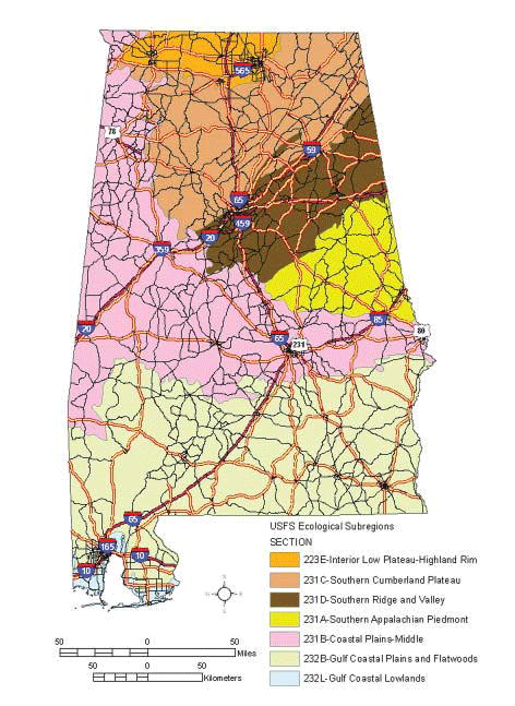
ECOREGIONS:
Alabama has seven ecoregions which follow the designations by Bailey and the US Forest Service. These ecoregions include: Interior Low Plateau-Highland
Rim; Southern Appalachian Piedmont; Coastal Plains-Middle; Southern Cumberland Plateau; Southern Ridge and Valley; Gulf Coastal Plains and Flatwoods;
and Gulf Coastal Lowlands.
SOURCES:
Cleland, DT., J. A. Freeouf, J. E. Keys Jr., G. J. Nowacki, C. Carpenter, W.H. McNab. 2007. Ecological subregions: sections and subsections of the conterminous
United States [1:3,500,000].
Sloan, A.M., cartog. Gen. Tech. Report WO-76.Washington, DC: U.S. Department of Agriculture, Forest Service. Map creator: Michael Barbour, GIS Analyst,
AL NHP, Auburn University, AL.
NHP CONTACT:
Alabama Natural Heritage Program 1090 South Donahue Drive Auburn University, AL 36849 Phone: 334-844-5019 Fax: 334-844-4462
GRASSLAND EXAMPLE:
An example of the Black Belt Prairie, a mosaic of natural grassland and hardwood forest and well represented throughout the Coastal Plain of west central
Alabama, is located along either side of County Road 9, roughly 0.1 road miles north of County Road 2, approximately 9.0 air miles southwest of downtown
Selma.
VISIT A PRESERVE
In addition to Department of Natural Resource preserves called Scientific and Natural Areas (SNAs), the Nature Conservancy (TNC) manages preserves in
all 50 States and in more than 30 countries. These protected lands include some of the best remnants of plant communities of grasslands, wetlands and
woodlands for your information. TNC is the leading conservation organization working to protect ecologically important lands and waters for nature and
people.
Locate and visit a preserve near you to see adapted native plant associations to inform your own project site decisions. Use the preserves inventory list
as your shopping list to match plant species to your planting project.
To access TNC preserve data as a source for Google Maps, or as a layer for Google Earth, you can use their feed url --
http://www.nature.org/placesweprotect/preserve-map.xml.
ALASKA ECOREGIONS
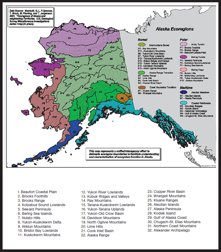
ECOREGIONS:
The Unified Ecoregions Map of Alaska combines the Bailey/US Forest Service and Omernik approaches. The ecoregions are described in detail (and shown in
greater clarity than can be provided here) at http://forestry.alaska.gov/pdfs/00ecoregions.pdf
SOURCES:
Nowacki, G.J.; P.Spencer; T.Brock; M.Fleming; and T.Jorgenson. 2001. Ecoregions of Alaska and Neighboring Territories. U.S. Geological Survey Miscellaneous
Investigations series I map (in press).
NHP CONTACT:
Program Manager/Program Ecologist Alaska Natural Heritage Program University of Alaska-Anchorage 707 A Street Anchorage, AK 99501 Phone: 907-257-2783
GRASSLAND EXAMPLE:
Calamagrostis canadensis (bluejoint) dominates the Bluejoint Grasslands, which is one of the most common and widespread grassland associations
in southeast and south central Alaska. Road accessible examples of this association occur along Hatcher Pass Road north of Palmer near Independence Mine State
Historical Park, and Turn Again Pass south of Anchorage along Highway 1.
VISIT A PRESERVE
In addition to Department of Natural Resource preserves called Scientific and Natural Areas (SNAs), the Nature Conservancy (TNC) manages preserves in
all 50 States and in more than 30 countries. These protected lands include some of the best remnants of plant communities of grasslands, wetlands and
woodlands for your information. TNC is the leading conservation organization working to protect ecologically important lands and waters for nature and
people.
Locate and visit a preserve near you to see adapted native plant associations to inform your own project site decisions. Use the preserves inventory list
as your shopping list to match plant species to your planting project.
To access TNC preserve data as a source for Google Maps, or as a layer for Google Earth, you can use their feed url --
http://www.nature.org/placesweprotect/preserve-map.xml.
ARKANSAS ECOREGIONS
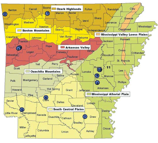
ECOREGIONS:
Arkansas has seven Level III ecoregions which follow the designations by Omernik. These ecoregions include Ozark Highlands; Boston Mountains; Arkansas
Valley; Ouachita Mountains; South Central Plains; Mississippi Alluvial Plain; and Mississippi Valley Loess Plains. Descriptions are available at
http://www.wildlifearkansas.com/ecoregions.html.
SOURCE:
Woods A.J., Foti, T.L. , Chapman, S.S., Omernik, J.M., Wise, J.A., Murray, E.O., Prior, W.L., Pagan, J.B., Jr., Comstock, J.A., and Radford, M., 2004,
Ecoregions of Arkansas (color poster with map, descriptive text, summary tables, and photographs). Reston, Virginia, U.S. Geological Survey (map
scale 1:1,000,000).
CONTACTS:
Arkansas Natural Heritage Commission 1500 Tower Building, 323 Center Street Little Rock, Arkansas 72201 Data Manager/Environmental Review Coordinator,
Phone: 501-324-9762
GRASSLAND EXAMPLE:
Grasslands in Arkansas’s ecoregions are listed below along with the Counties in which they are found and the map number associated with the grassland.
Descriptions and precise locations are available at http://www.naturalheritage.com/areas/map.asp.
OZARK HIGHLANDS
Baker Prairie Natural Area, Boone Co. Map # 1
Chesney Prairie Natural Area, Benton Co. Map # 2
ARKANSAS VALLEY
Cherokee Prairie Natural Area, Franklin Co. Map # 3
H. E. Flanagan Prairie Natural Area, Franklin Co. Map # 4
Saratoga Blackland Prairie Natural Area, Howard Co. Map # 5
SOUTH CENTRAL PLAINS:
Terre Noire Natural Area, Clark Co. Map # 6
Warren Prairie Natural Area, Bradley & Drew Cos. Map # 7
MISSISSIPPI ALLUVIAL PLAIN:
Roth Prairie Natural Area, Arkansas Co. Map # 8
Konecny Prairie Natural Area, Prairie Co. Map # 9
Railroad Prairie Natural Area, Prairie & Lonoke Cos. Map # 10
Downs Prairie Natural Area, Prairie Co. Map # 11
ARIZONA ECOREGIONS
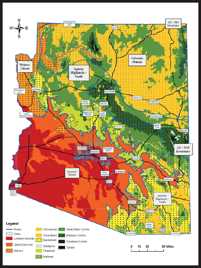
ECOREGIONS:
Under Arizona’s Comprehensive Wildlife Conservation Strategy (CWCS) six ecoregions are described following the designations of Omernik. These ecoregions
include: Colorado Plateau, Arizona-New Mexico Mountains, Apache Highlands North, Apache Highlands South, Sonoran Desert, and Mohave Desert.
SOURCE:
Arizona’s Natural Heritage Program(HDMS) https://www.azgfd.com/
CONTACT:
Arizona Game & Fish Department
WMHB - Project Evaluation Program
5000 W. Carefree Hwy
Phoenix, AZ 85086-5000
HDMS Program Coordinator
Phone: 623-236-7618
Fax: 623-236-7366
Additional contacts are listed at https://www.azgfd.com/.
VISIT A PRESERVE
In addition to Department of Natural Resource preserves called Scientific and Natural Areas (SNAs), the Nature Conservancy (TNC) manages preserves in
all 50 States and in more than 30 countries. These protected lands include some of the best remnants of plant communities of grasslands, wetlands and
woodlands for your information. TNC is the leading conservation organization working to protect ecologically important lands and waters for nature and
people.
Locate and visit a preserve near you to see adapted native plant associations to inform your own project site decisions. Use the preserves inventory list
as your shopping list to match plant species to your planting project.
To access TNC preserve data as a source for Google Maps, or as a layer for Google Earth, you can use their feed url --
http://www.nature.org/placesweprotect/preserve-map.xml.
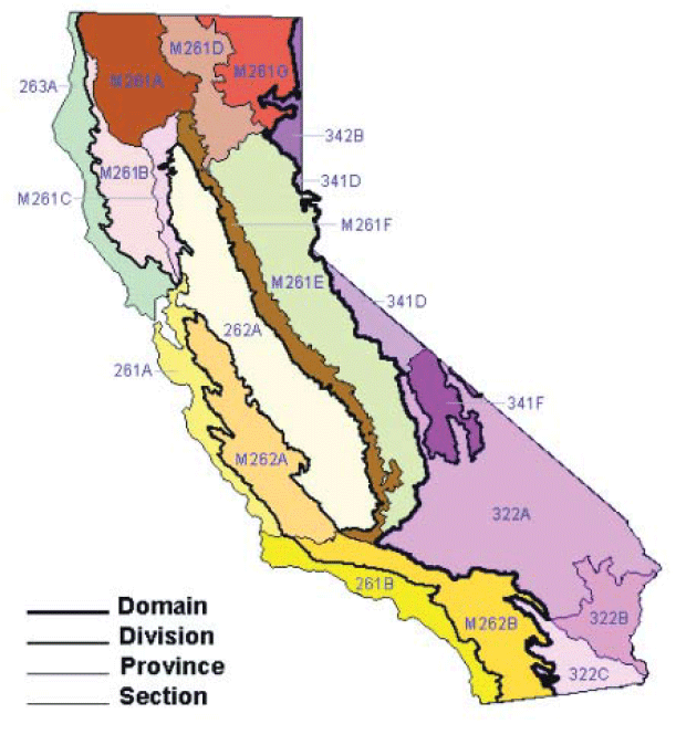
CALIFORNIA ECOREGIONS
261A: Central California Coast
261B: Southern California Coast
262A: Great Valley
263A: Northern California Coast
M261A: Klamath Mountains
M261B: Northern California Coast Ranges
M261C: Northern California Interior Coast Ranges
M261D: Southern Cascades
M261E: Sierra Nevada
M261F: Sierra Nevada Foothills
M261G: Modoc Plateau
M262A: Central California Coast Ranges
M262B: Southern California Mountains and Valleys
322A: Mojave Desert
322B: Sonoran Desert
322C: Colorado Desert
341D: Mono
341F: Southeastern Great Basin
342B: Northwestern Basin and Range
ECOREGIONS:
California has 19 ecological sections that follow the designations by Robert Bailey and the USDA, Forest Service. More information at http://www.dot.ca.gov/design/lap/.
SOURCE:
USDA, Forest Service https://www.fs.usda.gov/rmrs/ecoregions-united-states.
CONTACT:
Biogeographic Data Branch of the Calif.
Dept. of Fish and Game
1807 13th Street, Suite 202,
Sacramento, CA 95811
Phone: 916-322-2493
Fax: 916-324-0475
Web site: https://wildlife.ca.gov/Organization/BDB
GRASSLAND EXAMPLES:
The five major grassland types in California, recognized by many ecologists, are:
- COLD DESERT GRASSLANDS- NE part of Southern Cascades, Modoc Plateau, Northwestern Basin and Range, and Mono ecological sections.
- NORTH COASTAL GRASSLANDS- Northern to Central Calif. Coast ecological sections.
- SERPENTINEGRASSLANDS- on serpentine outcrops, similar to Valley grasslands.
- VALLEY/SOUTH COASTAL GRASSLANDS(also called Valley needle grass grassland, California prairie, or California annual grassland) found in the Great
Valley eco-logical section.
- WARM DESERT GRASSLANDS, found in Colorado, Southeastern Great Basin ecological sections.
References:
Todd Keeler-Wolf, Julie M. Evens, Ayzi K I. Solomeshch, V. L. Holland, And Michael G. Barbour. Chp. 3 Community Classification and Nomenclature
in Stromberg, M.R., J.D.Corbin, C.M. D’Antonio, Editors. 2007. California Grasslands: Ecology and Management. The Regents of the Univ. of Calif., Los
Angeles.http://www.cnps.org/cnps/vegetation/pdf/grassland_stromberg07_ch3.pdf
SITES TO VISIT:
GREAT VALLEY GRASSLANDS STATE PARK, San Joaquin Valley, remnant stands of Sporobolus airoides (native bunchgrass).
http://www.parks.ca.gov/.
TILDEN REGIONAL PARK, Wildcat Canyon near Berkeley has a coastal grassland site with native grasses, on Nimitz Way.
http://www.ebparks.org/parks/tilden.htm.
BEAR CREEK BOTANICAL MANAGEMENT AREA (BMA), 20 miles west of Williams along Highway 20 in western Colusa County. The BMA is a remnant of Inner Coast Range
vegetation. 20 BMAs are part of a Caltrans program that identifies, preserves and manages significant native plant communities along roadsides.
The California Native Grasslands Association has a "Guide to Visiting California’s Grasslands" at http://www.cnga.org/visitor_guide.html.
COLORADO ECOREGIONS
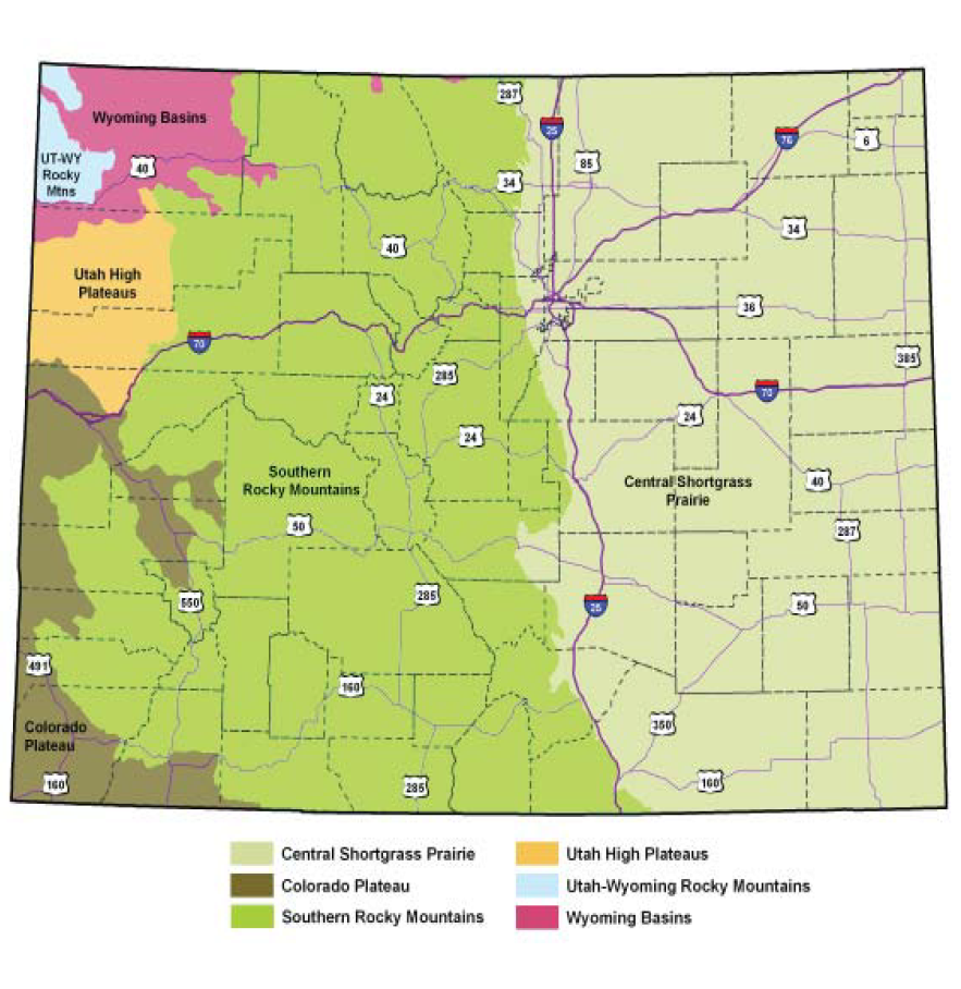
ECOREGIONS:
Colorado contains parts of six ecoregions as delineated by The Nature Conservancy (modified from Bailey 1995,
https://www.fs.usda.gov/rmrs/ecoregions-united-states/). East of the mountain front the State is part of the Central Shortgrass Prairie. The mountainous
central portion of the State forms the bulk of the Southern Rocky Mountains ecoregion. On the western edge of the State, four ecoregions are shared with
neighboring States: Wyoming Basins, Utah-Wyoming Rocky Mountains, Utah High Plateaus, and the Colorado Plateau.
SOURCE:
Colorado Natural Heritage Program to http://www.cnhp.colostate.edu/.
NHP CONTACT:
Environmental Review Coordinator Colorado Natural Heritage Program
Colorado State University
8002 Campus Delivery
Fort Collins, CO 80523-8002
Phone: 970-491-7331
GRASSLAND EXAMPLES:
Grasslands in Colorado are greatly influenced by elevation and local climate. On the eastern plains, Shortgrass Prairie is typical. With increasing elevation
and precipitation at the transition between plains and mountains, Foothills-Piedmont Grassland types appear. In the higher, wetter elevations of the Southern
Rocky Mountains, a variety of Montane Grasslands and Subalpine Grasslands are found. Sparse Semi-desert Grassland communities are typical of the drier,
warmer mesas and canyons of the western slope. Maps of natural areas, including grassland examples, in Colorado are available at
https://www.fs.usda.gov/Internet/FSE_DOCUMENTS/stelprdb5389835.html.
The U.S.D.A. Forest Service manages the following National Grasslands in Colorado. Information and links located at
https://www.fs.usda.gov/recmain/arp/recreation.
- Comanche National Grassland is located in southeastern Colorado in two areas: south of Springfield and southwest of La Junta.
- Pawnee National Grassland located in north central Colorado east of Ft. Collins in an area bounded by Routes 85, 14 and 71.
- Gila National forest, 9,075 acres.
CONNECTICUT ECOREGIONS
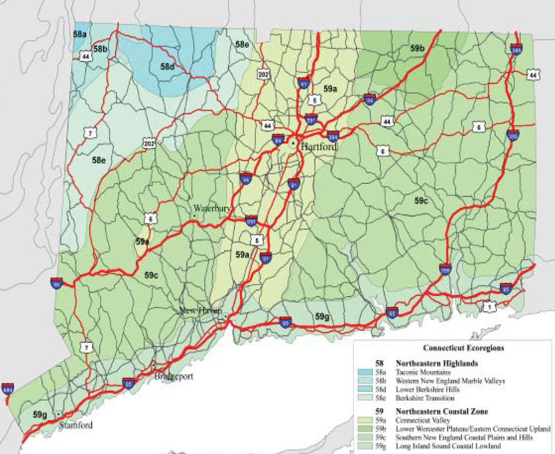
ECOREGIONS:
Connecticut has two Level III ecoregions following the designations by Omernik. These ecoregions are Northeastern Highlands and Northeastern Coastal Zone,
which are further subdivided into four Level IV ecoregions each. These ecoregions are shown on the attached map and described at
https://www.epa.gov/eco-research/level-iii-and-iv-ecoregions-continental-united-states.
SOURCE:
U.S. Environmental Protection Agency, Western Ecology Division, Corvallis, Oregon https://www.epa.gov/eco-research/level-iii-and-iv-ecoregions-continental-united-states.
BNR CONTACT:
Connecticut Natural Diversity Database Bureau of Natural Resources, Wildlife Division
Department of Environmental Protection
79 Elm Street, Sixth Floor
Hartford, CT 06106-5127
Phone: 860-424-3540
Fax: 860-424-4058
GRASSLAND EXAMPLE:
Connecticut’s Department of Environmental Protection has produced a guideline entitled “Managing Grasslands, Shrublands, and Young Forest Habitats”
which provides useful information on managing grasslands. The document can be obtained from the DEP Online Store http://www.ct.gov/dep/cwp,
79 Elm St
Hartford, CT 06106-5127
Phone: 860-424-3555, Fax: 860-424-4088.
VISIT A PRESERVE
In addition to Department of Natural Resource preserves called Scientific and Natural Areas (SNAs), the Nature Conservancy (TNC) manages preserves in
all 50 States and in more than 30 countries. These protected lands include some of the best remnants of plant communities of grasslands, wetlands and
woodlands for your information. TNC is the leading conservation organization working to protect ecologically important lands and waters for nature and
people.
Locate and visit a preserve near you to see adapted native plant associations to inform your own project site decisions. Use the preserves inventory list
as your shopping list to match plant species to your planting project.
To access TNC preserve data as a source for Google Maps, or as a layer for Google Earth, you can use their feed url -
http://www.nature.org/placesweprotect/preserve-map.xml.
DELAWARE ECOREGIONS
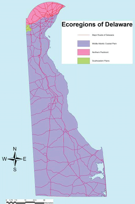
ECOREGIONS:
Delaware has three Level III ecoregions, including: Middle Atlantic Coastal Plain, Northern Piedmont, and Southeastern Plains.
SOURCE:
Ecoregion map was drawn by Robert Coxe based on EPA Level III maps following Omernick’ designations. Roads data are from Delaware Department of Transportation.
NHP CONTACT:
Delaware Natural Heritage Program Division of Fish & Wildlife
Dept. of Natural Resources & Environ. Control
89 Kings Highway,
Dover, DE 19901
Phone: 302-653-2880
Fax: 302-653-3431
GRASSLAND EXAMPLE:
A suitable example is located on DE Route 273 and I-95 Roadside, on the roadside of the southbound DE 273 onramp to I-95. This 5 acre area is managed
with different levels of mowing: regularly mowed roadside strip, yearly mowed zone, shrub zone mowed once every five years and unmowed area. Prior to
1998, this entire area was mowed to a tree line. It has been allowed to grow since then and a grassland, forb, shrub and tree community has developed.
Most of the area is dry, but a drainage ditch through the center provides a moist zone. The unmowed zones are spot sprayed to reduce incursion of invasive
species. Species include switch grass (Panicum virgatum), little bluestem (Schizacharium scoparium), rugose goldenrod (Solidago rugosa),
hyssop-leaf thoroughwort (Eupatorium hyssopifolium), three-nerved joe-pye weed (Eupatorium dubium), sweet pepperbush (Clethra alnifolia),
highbush blueberry (Vaccinium corymbosum), arrow-wood (Viburnum dentatum), sweet gum (Liquidambar styraciflua), red maple (Acer
rubrum) and many more.
VISIT A PRESERVE
In addition to Department of Natural Resource preserves called Scientific and Natural Areas (SNAs), the Nature Conservancy (TNC) manages preserves in
all 50 States and in more than 30 countries. These protected lands include some of the best remnants of plant communities of grasslands, wetlands and
woodlands for your information. TNC is the leading conservation organization working to protect ecologically important lands and waters for nature and
people.
Locate and visit a preserve near you to see adapted native plant associations to inform your own project site decisions. Use the preserves inventory list
as your shopping list to match plant species to your planting project.
To access TNC preserve data as a source for Google Maps, or as a layer for Google Earth, you can use their feed url --
http://www.nature.org/placesweprotect/preserve-map.xml.
FLORIDA ECOREGIONS
ECOREGIONS:
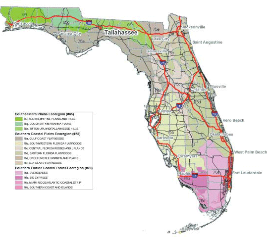
Florida has three Level III ecoregions: (65) Southeastern Plains, (75) Southern Coastal Plain, and (76) Southern Florida Coastal Plain. Descriptions of
these ecoregions are found at US EPA’s Western Ecology Division web site at https://www.epa.gov/eco-research/ecoregions
SOURCE:
Florida Department of Transportation,
Environmental Management Office,
605 Suwannee St MS 37
Tallahassee, FL 32399
Phone: 850-414-4447.
FNAI CONTACT:
Florida Natural Areas Inventory
1018 Thomasville Road, Suite 200-C
Tallahassee, FL 32303
Phone: 850-224-8207
Web >site: http://www.fnai.org/
GRASSLAND EXAMPLES:
MESIC FLATWOODS are flatland with sand substrate; mesic; subtropical or temperate; frequent fire; slash pine and/or longleaf pine with saw palmetto,
gallberry and/or wiregrass or cutthroat grass understory. Although forested, this natural community is basically grassland with a thin, open-canopy
of pines. Reference site: Apalachicola National Forest, 30 05 34.4 N, 85 02 28.8 W.
SANDHILL are upland with deep sand substrate; xeric; temperate; frequent fire (2-5 years); longleaf pine and/or turkey oak with wiregrass understory;
also a lightly forested natural community with a grassy understory. Reference site: Ocala National Forest, 29 27 16.6 N, 81 48 32.7 W.
DRY PRAIRIE are flatland with sand substrate; mesic-xeric; subtropical or temperate; annual or frequent fire; wiregrass, saw palmetto, and mixed grasses
and herbs; as much a shrubland as grassland. Reference site: Kissimmee Prairie Preserve State Park, 27 34 52.1 N, 81 01 59.4 W.
VISIT A PRESERVE
In addition to Department of Natural Resource preserves called Scientific and Natural Areas (SNAs), the Nature Conservancy (TNC) manages preserves in
all 50 States and in more than 30 countries. These protected lands include some of the best remnants of plant communities of grasslands, wetlands and
woodlands for your information. TNC is the leading conservation organization working to protect ecologically important lands and waters for nature and
people.
Locate and visit a preserve near you to see adapted native plant associations to inform your own project site decisions. Use the preserves inventory list
as your shopping list to match plant species to your planting project.
To access TNC preserve data as a source for Google Maps, or as a layer for Google Earth, you can use their feed url --
http://www.nature.org/placesweprotect/preserve-map.xml.
GEORGIA ECOREGIONS
ECOREGIONS:
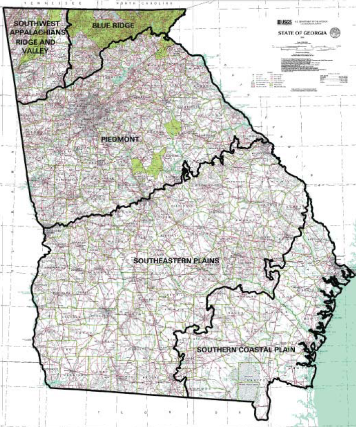
Georgia has five Level III ecoregions, including: Southwest Appalachians Ridge and Valley, Blue Ridge, Piedmont, Southeastern Plains, and Southern Coastal
Plains.
SOURCE:
Map was downloaded in November 2008 from the Georgia GIS Data Clearinghouse https://gis1.state.ga.us/index.asp
by Chris Canalos, Georgia DNR. Original data from: Griffith, G.E., J.M. Omernik, J.A. Comstock, S. Lawrence, G. Martin, A. Goddard, V.J. Hulcher, and
T. Fulcher. 2001. Ecoregions of Alabama and Georgia.
U.S. Geological Survey, Reston, VA; and U.S. Geological Survey. 2001. State of Georgia topographic map (DRG), 1:500,000. Reston, VA, U.S. Geological Survey.
DNR CONTACT:
Georgia Department of Natural Resources Wildlife Resources Division Nongame Conservation Section 2065 US Hwy 278, SE
Social Circle, GA 30025
Phone: 770-918-6411 or 706-557-3032
GRASSLAND EXAMPLES:
Red Top Mountain State Park in Bartow County northwest of Atlanta on Rt. 75, has some narrow strips of native grasses by the sides of Red Top Mountain
Road which runs through the park. The coordinates for the location are N 34.13989755, W -84.69890775 (WGS84); or UTM 17: 3783852.30000194, 158886.53988348.
VISIT A PRESERVE
In addition to Department of Natural Resource preserves called Scientific and Natural Areas (SNAs), the Nature Conservancy (TNC) manages preserves in
all 50 States and in more than 30 countries. These protected lands include some of the best remnants of plant communities of grasslands, wetlands and
woodlands for your information. TNC is the leading conservation organization working to protect ecologically important lands and waters for nature and
people.
Locate and visit a preserve near you to see adapted native plant associations to inform your own project site decisions. Use the preserves inventory list
as your shopping list to match plant species to your planting project.
To access TNC preserve data as a source for Google Maps, or as a layer for Google Earth, you can use their feed url --
http://www.nature.org/placesweprotect/preserve-map.xml.
HAWAII ECOREGIONS
ECOREGIONS:
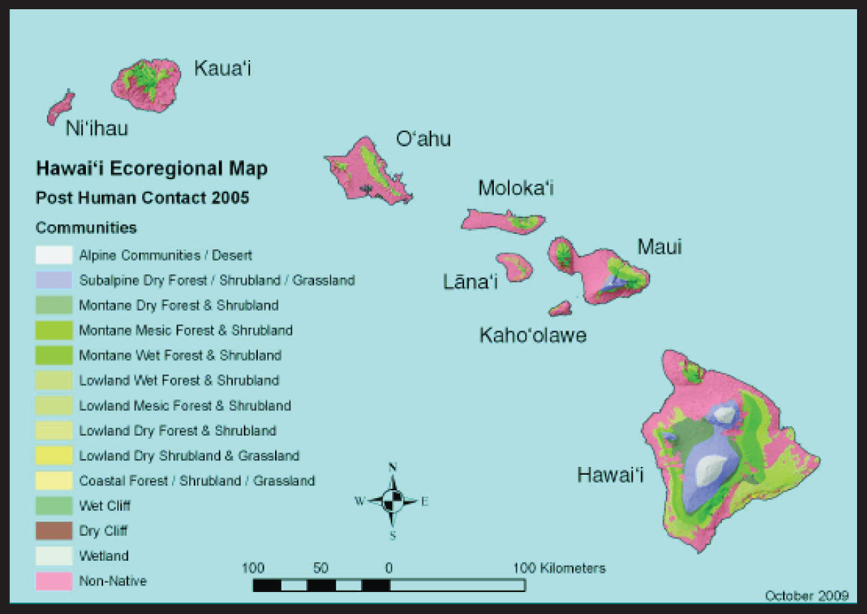
Three ecoregion categories (Alpine, Subalpine and Coastal) are grouped according to elevation, moisture, and physiognomy, following the natural community
classification currently in use by The Nature Conservancy of Hawaii see http://www.hawaiiecoregionplan.info/introduction.
html. For more information see the Atlas of Hawaii, Chapter “Terrestrial Ecosystems”. Fourteen communities, including nonnative vegetation,
are shown in the attached map.
SOURCE:
Hawaii Biodiversity & Mapping Program Juvik, S.P., J.O. Juvik, and T.R. Paradise. 1998. Atlas of Hawaii Third Edition. University of Hawaii
Press. ISBN-10 0824821254.
CONTACT:
Hawaii Biodiversity & Mapping Program
University of Hawaii at Manoa Center for Conservation Research & Training
3050 Maile Way, Gilmore Hall 406
Honolulu, HI 96822
Phone: 808-956-8094
Fax: 808-956-8493
GRASSLAND EXAMPLES:
The vegetation of Hawaii is unique for many reasons and there are few remaining native grasslands. The Nature Conservancy’s Mo’omomi Preserve has good
examples of coastal area grassland with ’aki’aki (Sporobolus virginicus) with mixed native coastal subshrubs. In the NW Hawaiian Islands, there
are kawelu (Eragrostis variabilis) grasslands, also with native coastal shrubs. Examples of high elevation native grasslands include subalpine
East Maui, dominated by Deschampsia spp., and the Mauna Kea grasslands which are dominated by Hawaiian bentgrass (Agrostis sandwicensis),
and pili uka (Trisetum glomeratum).
VISIT A PRESERVE
In addition to Department of Natural Resource preserves called Scientific and Natural Areas (SNAs), the Nature Conservancy (TNC) manages preserves in
all 50 States and in more than 30 countries. These protected lands include some of the best remnants of plant communities of grasslands, wetlands and
woodlands for your information. TNC is the leading conservation organization working to protect ecologically important lands and waters for nature and
people.
Locate and visit a preserve near you to see adapted native plant associations to inform your own project site decisions. Use the preserves inventory list
as your shopping list to match plant species to your planting project.
To access TNC preserve data as a source for Google Maps, or as a layer for Google Earth, you can use their feed url --
http://www.nature.org/placesweprotect/preserve-map.xml.
IOWA ECOREGIONS
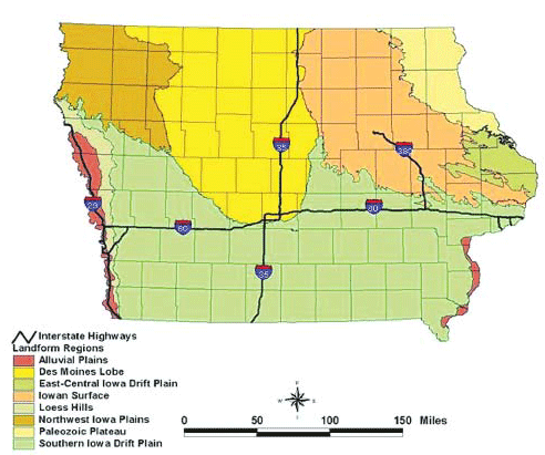
ECOREGIONS:
Iowa has eight landforms regions, including: Alluval Plains, Des Moines Lobe, EastCentral Iowa Drift Plain, Iowan Surface, Loess Hills, Northwest Iowa
Plains, Palezoic Plateau, and Southern Iowa Drift Plain. Descriptions of the landform regions and historic plant communities in each region are available
at http://www.iowadnr.gov/.
SOURCE:
Iowa Department of Natural Resources http://www.iowadnr.gov/
DNR CONTACT:
Plant Ecologist
Department of Natural Resources
Wallace State Office Building
502 East 9th Street
Des Moines, IA 50319-0034
Phone: 515-281-3891
GRASSLAND EXAMPLE:
The Hayden Prairie, a 242-acre native prairie, is located in Howard County, 4.9 miles west of Lime Springs on A23 at the Intersection of Jade Avenue and
50th Street. Information and map at
http://www.iowadnr.gov/.
VISIT A PRESERVE
In addition to Department of Natural Resource preserves called Scientific and Natural Areas (SNAs), the Nature Conservancy (TNC) manages preserves in
all 50 States and in more than 30 countries. These protected lands include some of the best remnants of plant communities of grasslands, wetlands and
woodlands for your information. TNC is the leading conservation organization working to protect ecologically important lands and waters for nature and
people.
Locate and visit a preserve near you to see adapted native plant associations to inform your own project site decisions. Use the preserves inventory list
as your shopping list to match plant species to your planting project.
To access TNC preserve data as a source for Google Maps, or as a layer for Google Earth, you can use their feed url --
http://www.nature.org/placesweprotect/preserve-map.xml.
IDAHO ECOREGIONS
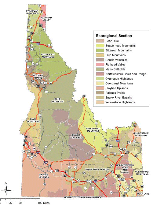
ECOREGIONS:
Idaho encompasses 14 sections of four Level III ecoregions following the Omernik designations. There are 5 major grassland ecological systems in the State.
The extent of these 5 grassland ecological systems, the ecoregion in which they are found, and the common grassland species found in each are listed under
“Grassland Examples”.
SOURCE:
https://www.epa.gov/eco-research/level-iii-and-iv-ecoregions-continental-united-states
CONTACT:
Habitat andRestoration Ecologist Idaho Department of Fish and Game, Wildlife Bureau, Habitat Section
600 S. Walnut St., P.O. Box 25
Boise, ID 83707
Phone: 208-287-2728
GRASSLAND EXAMPLES:
CANYON GRASSLANDS are found in the Blue Mountains and Idaho Batholith ecoregions; species present include: red threeawn (Aristida purpurea var. longiseta);
Idaho fescue (Festuca idahoensis); needle and thread (Hesperostipa comata); Sandberg’s bluegrass (Poa secunda); bluebunch wheatgrass
(Pseudoroegneria spicata); sand dropseed (Sporobolus cryptandrus).
THE CECIL D. ANDRUS WILDLIFE MANAGEMENT AREA, one of the best places to view canyon grassland communities, is located in Washington County about 18 miles
northwest of Cambridge along Highway 71. About 45% of the 24,000-ac WMA is comprised of canyon grasslands.
MESIC MEADOWS are found in the Beaverhead Mountains and Idaho Batholith ecoregions; species present include: timber oatgrass (Danthonia intermedia);
tufted hairgrass (Deschampsia caespitosa).
PALOUSE PRAIRIES are found in the Palouse Prairie ecoregion; species present include: Idaho fescue; bluebunch wheatgrass (Pseudoroegneria spicata).
SUBALPINE AND ALPINE GRASSLANDS are found in the Beaverhead Mountains, Challis Volcanics, and Overthrust Mountains ecoregions; species present include:
slender wheatgrass (Elymus trachycaulus); rough fescue (Festuca campestris); Idaho fescue; greenleaf fescue (Festuca viridula);
spike fescue (Leucopoa kingii).
MOUNTAIN FOOTHILL AND VALLEY GRASSLANDS are found in the Okanogan Highlands, Owyhee Uplands, and Snake River Basalts ecoregions; species present include:
Indian ricegrass (Achnatherum hymenoides); red threeawn; squirreltail (Elymus elymoides); rough fescue; Idaho fescue; needle and thread;
basin wildrye (Leymus cinereus); western wheatgrass (Pascopyrum smithii); Sandberg’s bluegrass; bluebunch wheatgrass; sand dropseed.
ILLINOIS ECOREGIONS
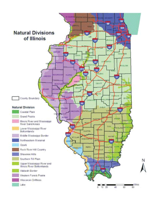
ECOREGIONS:
Illinois contains 14 natural divisions which are classified natural environments and biotic communities based upon physiography (topography, soil and
bedrock), natural vegetation, climate, flora and fauna. Descriptions for each natural division can be found within the source cited here.
SOURCE:
Schwegman, J.E. 1972. Comprehensive Plan For The Illinois Nature Preserves System, Part 2 - The Natural Divisions Of Illinois. Illinois Nature
Preserves Commission, Rockford, IL. 32 pp. http://archive.org/details/comprehensivepla02illi
DNR CONTACT:
Natural Areas Program Manger Illinois
Department of Natural Resources
One Natural Resources Way
Springfield, IL 62702
Phone: 217-785-8774
http://dnr.state.il.us/conservation/naturalheritage/
GRASSLAND EXAMPLE:
The Prairie Ridge State Natural Area is found in Jasper and Marion Counties, SW of Newton. The site contains a mosaic of habitat types including native
remnant prairies, restored native grasses, wetlands, cool season grasses, habitats prepared by annual discing for brood-rearing of prairie-chickens and
other birds, woodlands/old fields, cropland being converted into grassland, and miscellaneous areas such as buildings sites and waterways. Management
of this area includes the development of grassland plant communities of native prairie species and introduced grasses. Wetland communities have been constructed
to provide habitat for 15 state threatened and endangered wetland dependent species. Directions: From State Highway 33 turn south on Bogota Road (990
N 900E) and go 4 miles to first curve in road. Go straight off curve to crossroads (600N 900E), turn left (east) for 1 mile or first crossroad (600N 1000E)
then turn right (south) and go 1 3/4 miles to white house with wire fence. http://dnr.state.il.us/orc/prairieridge/index.htm
VISIT A PRESERVE
In addition to Department of Natural Resource preserves called Scientific and Natural Areas (SNAs), the Nature Conservancy (TNC) manages preserves in
all 50 States and in more than 30 countries. These protected lands include some of the best remnants of plant communities of grasslands, wetlands and
woodlands for your information. TNC is the leading conservation organization working to protect ecologically important lands and waters for nature and
people.
Locate and visit a preserve near you to see adapted native plant associations to inform your own project site decisions. Use the preserves inventory list
as your shopping list to match plant species to your planting project.
To access TNC preserve data as a source for Google Maps, or as a layer for Google Earth, you can use their feed url --
http://www.nature.org/placesweprotect/preserve-map.xml.
INDIANA ECOREGIONS
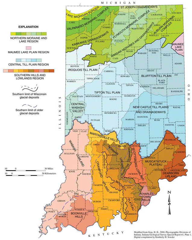
ECOREGIONS:
Indiana has six ecoregions which follow the USGS designations. These ecoregions include: Central Corn Belt Plains; Eastern Corn Belt Plains; Huron /
Erie Lake Plains; Interior Plateau; Interior River Valleys and Hills; and S. Michigan / N. Indiana Drift Plains.
SOURCE:
Homoya, Michael A., D. Brian Abrell, James R. Aldrich and Thomas W. Post. 1985. The Natural Regions of Indiana. Proc. Ind. Acad. Sci. 94:245-268.
Map Drafted by Roger L. Purcell, Indiana Geological Survey. http://www.naturalheritageofindiana.org/learn/regions.html
DNR CONTACT:
Heritage Program Coordinator Indiana Department of Natural Resources
Division of Nature Preserves
402 W. Washington St., Rm W267
Indianapolis, IN 46204
Phone: 317-232-4078
http://www.in.gov/dnr/naturepreserve/
GRASSLAND EXAMPLE:
The Hoosier Prairie, within the Northwestern Morainal Natural Region, is located east of U.S. 41 on Main Street in Griffith. This site contains dry black
oak savannas with mesic sand prairie openings on slopes between the rises and swales. Nearly 500 acres in size, this State Dedicated Nature Preserve is
managed by prescribed fire and mechanical removal of select trees and shrubs.
VISIT A PRESERVE
In addition to Department of Natural Resource preserves called Scientific and Natural Areas (SNAs), the Nature Conservancy (TNC) manages preserves in
all 50 States and in more than 30 countries. These protected lands include some of the best remnants of plant communities of grasslands, wetlands and
woodlands for your information. TNC is the leading conservation organization working to protect ecologically important lands and waters for nature and
people.
Locate and visit a preserve near you to see adapted native plant associations to inform your own project site decisions. Use the preserves inventory list
as your shopping list to match plant species to your planting project.
To access TNC preserve data as a source for Google Maps, or as a layer for Google Earth, you can use their feed url --
http://www.nature.org/placesweprotect/preserve-map.xml.
KANSAS ECOREGIONS
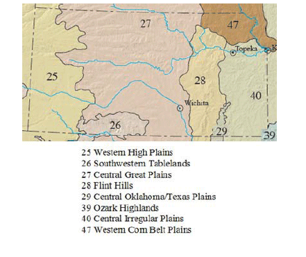
ECOREGIONS:
Kansas is divided into 8 Level II ecoregions: 47 Western Corn Belt Plains, 40 Central Irregular Plains, 39 Ozark Highlands, 29 Central Oklahoma/Texas
Plains, 28 Flint Hills, 27 Central Great Plains, 26 Southwestern Tablelands, and 25 Western High Plains. Descriptions of each ecoregion can be found on
the web site listed under Source.
SOURCE:
US EPA https://www.epa.gov/eco-research/ecoregions-north-america
CONTACT:
Community Ecologist
Kansas Natural Heritage Inventory
Kansas Biological Survey
2101 Constant Ave.
Lawrence, KS 66047-3759
Phone: 785-864-1500
GRASSLAND EXAMPLES:
Konza Prairie Biological Station, located approximately 13 km south of Manhattan, Kansas, is a 3487-hectare site dominated by native Flint Hills tallgrass
prairie. Owned by The Nature Conservancy and Kansas State University, it is operated as a field research station by the K-State Division of Biology. Habitats
include upland prairie on thin loess soils, hill prairie along alternating limestone benches and slopes, and lowland prairie on alluvial-colluvial soils.
Gallery forests dominated by bur and chinquapin oaks and hackberry occur along the major stream courses. Site access is limited; see
http://kpbs.konza.ksu.edu/.
The following are additional native grasslands found in the ecoregions of Kansas. This information is taken from the Kansas Native Plant Society web site
at http://www.kansasnativeplantsociety.org/ecoregions.php
39 OZARK HIGHLANDS: Spring River Wildlife Area, Cherokee Co. (undisturbed prairie meadow).
40 CENTRAL IRREGULAR PLAINS: Harmon Wildlife Area, Labette Co. (undisturbed prairie meadow); Ivan Boyd Memorial Prairie Preserve, Douglas Co., (tallgrass
prairie).
47 WESTERN CORN BELT PLAINS: Olathe Prairie Center, Johnson Co., (remnant prairie).
28 FLINT HILLS: Tallgrass National Preserve, Chase Co., (tallgrass prairie).
25 WESTERN HIGH PLAINS: Cimarron National Grasslands, Morton Co., (sandsage prairie).
KENTUCKY ECOREGIONS
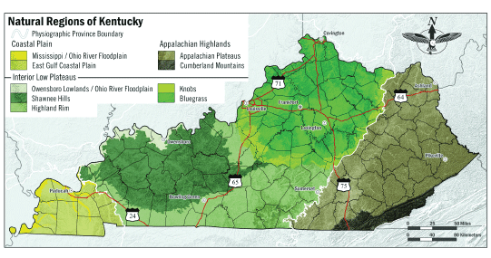
ECOREGIONS:
Kentucky has three major physiographic regions, including: Coastal Plain, Appalachian Highlands, and Interior Low Plateaus.
SOURCE:
Evans, Marc and Abernathy, Greg. 2008. Natural Regions of Kentucky Map. Kentucky State Nature Preserves Commission, Frankfort, Kentucky.
NPC CONTACT:
Heritage Branch Manager Kentucky State Nature Preserves Commission
801 Schenkel Lane
Frankfort, KY 40601
Phone: 502-573-2886
GRASSLAND EXAMPLE:
Logan County Glade State Nature Preserve is 41 acres of limestone glades in Russellville, and has areas dominated by little bluestem (Schizachyrium scoparium)
and side-oats grama (Bouteloua curtipendula). A permit is required to access some areas. Located in Logan County: From the junction of the Green River
Parkway and U.S. 68/KY 80 at Bowling Green, follow U.S. 68/KY 80 west for 24.4 miles to Russellville. Turn right into parking area between Health
Department and old hospital. Additional grasslands in Kentucky’s State Nature Preserves and State Natural Areas system are listed at
https://eec.ky.gov/Nature-Preserves/Locations/Pages/default.aspx. Note that access to some areas is limited.
VISIT A PRESERVE
In addition to Department of Natural Resource preserves called Scientific and Natural Areas (SNAs), the Nature Conservancy (TNC) manages preserves in
all 50 States and in more than 30 countries. These protected lands include some of the best remnants of plant communities of grasslands, wetlands and
woodlands for your information. TNC is the leading conservation organization working to protect ecologically important lands and waters for nature and
people.
Locate and visit a preserve near you to see adapted native plant associations to inform your own project site decisions. Use the preserves inventory list
as your shopping list to match plant species to your planting project.
To access TNC preserve data as a source for Google Maps, or as a layer for Google Earth, you can use their feed url --
http://www.nature.org/placesweprotect/preserve-map.xml.
LOUISIANA ECOREGIONS
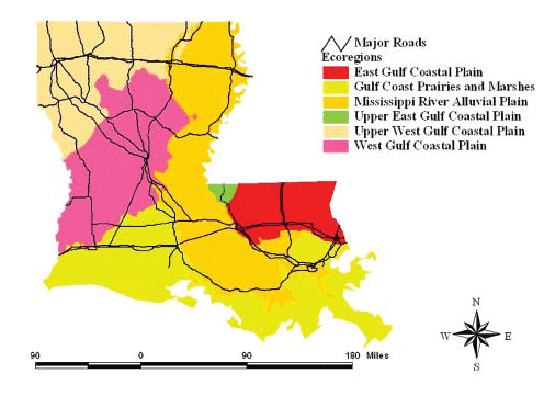
ECOREGIONS:
Louisiana has six ecoregions which follow the designations by The Nature Conservancy. These ecoregions include: East Gulf Coastal Plain; Gulf Coast Prairies
and Marshes; Mississippi River Alluvial Plain; Upper East Gulf Coastal Plain; Upper West Gulf Coastal Plain; and West Gulf Coastal Plain.
SOURCE:
Louisiana Natural Heritage Program, http://www.nature.org/ourinitiatives/regions/northamerica/unitedstates/louisiana/explore/index.htm
CONTACT:
Botanist Louisiana Natural Heritage Program Louisiana Department of Wildlife & Fisheries
2000 Quail Drive
Baton Rouge, LA 70898-9000
Phone: 225-765-2800
GRASSLAND EXAMPLE:
Iowa-Fenton Prairie Remnant, located between Iowa and Fenton beside RR tracks on east side of US 165, North of junction with I-10. The Nature Conservancy
has a seed lease and is performing stewardship (chemical and mechanical control of woody vegetation plus burning) on this remnant prairie strip.
VISIT A PRESERVE
In addition to Department of Natural Resource preserves called Scientific and Natural Areas (SNAs), the Nature Conservancy (TNC) manages preserves in
all 50 States and in more than 30 countries. These protected lands include some of the best remnants of plant communities of grasslands, wetlands and
woodlands for your information. TNC is the leading conservation organization working to protect ecologically important lands and waters for nature and
people.
Locate and visit a preserve near you to see adapted native plant associations to inform your own project site decisions. Use the preserves inventory list
as your shopping list to match plant species to your planting project.
To access TNC preserve data as a source for Google Maps, or as a layer for Google Earth, you can use their feed url --
http://www.nature.org/placesweprotect/preserve-map.xml.
MAINE ECOREGIONS
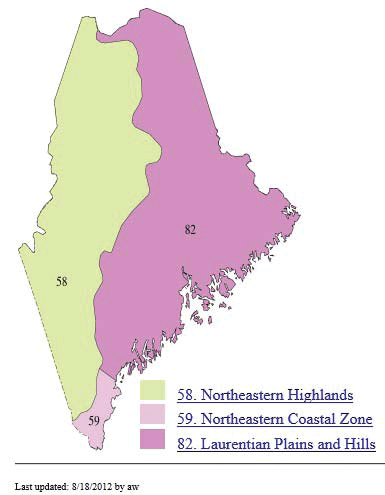
ECOREGIONS:
Maine contains three Level III ecoregions, following the designations by Omernik. These ecoregions include: 58. Northeastern Highlands; 59. Northeastern
Coastal Zone; and 82. Laurentian Plains and Hills.
SOURCE:
Omernik, J.M. 1987. Ecoregions of the conterminous United States. Map (scale 1:7,500,000). Annals of the Association of American Geographers 77(1):118-125.
https://www.epa.gov/eco-research/level-iii-and-iv-ecoregions-continental-united-states.
CONTACT:
Maine Natural Areas Program Natural Areas Division Department of Conservation
93 State House Station
Augusta, Maine 04333-0093
Phone: 207-287-8044 or 8046
Fax: 207-287-8040
Email: maine.nap@maine.gov
Web site: https://www.maine.gov/dacf/mnap/index.html
GRASSLAND EXAMPLE:
The largest native grassland in Maine, the Kennebunk Plains, is located 5 miles west of the Town of Kennebunk in the Northeastern Coastal Zone of southern
Maine. More information is available at
http://www.nature.org/ourinitiatives/regions/northamerica/unitedstates/maine/placesweprotect/kennebunk-plains.xml.
VISIT A PRESERVE
In addition to Department of Natural Resource preserves called Scientific and Natural Areas (SNAs), the Nature Conservancy (TNC) manages preserves in
all 50 States and in more than 30 countries. These protected lands include some of the best remnants of plant communities of grasslands, wetlands and
woodlands for your information. TNC is the leading conservation organization working to protect ecologically important lands and waters for nature and
people.
Locate and visit a preserve near you to see adapted native plant associations to inform your own project site decisions. Use the preserves inventory list
as your shopping list to match plant species to your planting project.
To access TNC preserve data as a source for Google Maps, or as a layer for Google Earth, you can use their feed url --
http://www.nature.org/placesweprotect/preserve-map.xml
MARYLAND ECOREGIONS
ECOREGIONS:
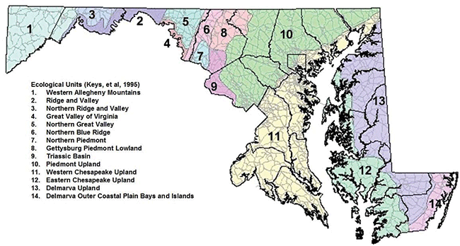
Maryland has 14 ecological units which follow the designations by the US Forest Service. These ecological units include: Western Allegheny Mountains;
Ridge and Valley; Northern Ridge and Valley; Great Valley of Virginia; Northern Great Valley; Northern Blue Ridge; Northern Piedmont; Gettysburg Piedmont
Lowland; Triassic Basin; Piedmont Upland; Western Chesapeake Upland; Eastern Chesapeake Upland; Delmarva Upland; and Delmarva Outer Coastal Plain Bays
and Islands.
SOURCES:
Harrison, J.W. 2007. The Natural Communities of Maryland: Draft. Maryland Department of Natural Resources, Wildlife and Heritage Service, Annapolis,
MD. Unpublished report. July 2007. 112 pp.
Keys, Jr., J.; Carpenter, C.; Hooks, S.; Koenig, F.; McNab, W.H.; Russell, W.; Smith, M.L. 1995. Ecological units of the eastern United States - first
approximation (CD-ROM), Atlanta, GA: U.S. Department of Agriculture, Forest Service.
GIS coverage in ARCINFO format, selected imagery, and map unit tables. Map created by Jason Harrison, October 2008.
DNR CONTACT:
MD DNR Wildlife and Heritage Service Headquarters
Tawes State Office Building
E-1 580 Taylor Ave
Annapolis, MD 21401
Phone: 410-260-8540
Fax: 410-260-8596
http://www.dnr.state.md.us/wildlife/
GRASSLAND EXAMPLES:
The Serpentine Barren, located at Soldiers Delight Natural Environmental Area, is approximately 1,900 acres of woodland and grassland savanna habitat
on serpentine soils. It supports native grasses and numerous rare plant species. Serpentine barrens are kept from succeeding to closed forests by periodic
fire, edaphic factors, and unstable substrates. Directions: Take I-795, to Franklin Blvd. West, right at Church Road, left on Berrymans Lane, then left
on Deer Park Road. More information is available at http://www.dnr.state.md.us/publiclands/central/soldiersdelight.asp.
VISIT A PRESERVE
In addition to Department of Natural Resource preserves called Scientific and Natural Areas (SNAs), the Nature Conservancy (TNC) manages preserves in
all 50 States and in more than 30 countries. These protected lands include some of the best remnants of plant communities of grasslands, wetlands and
woodlands for your information. TNC is the leading conservation organization working to protect ecologically important lands and waters for nature and
people.
Locate and visit a preserve near you to see adapted native plant associations to inform your own project site decisions. Use the preserves inventory list
as your shopping list to match plant species to your planting project.
To access TNC preserve data as a source for Google Maps, or as a layer for Google Earth, you can use their feed url --
http://www.nature.org/placesweprotect/preserve-map.xml.
MASSACHUSETTS ECOREGIONS
ECOREGIONS:
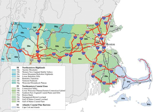
Massachusetts has three Level III ecoregions which follow the designations by Omernik. These ecoregions are Northeastern Highlands; Northeastern Coastal
Zone; and Atlantic Coastal Pine Barrens. Each ecoregion has Level IV ecoregions within it. Descriptions of these ecoregions are available at https://www.epa.gov/eco-research/ecoregions.
SOURCE:
Dynamac Corporation (Under contract to USEPA)
200 SW 35th St.
Corvallis, Oregon 97333
CONTACT:
Massachusetts State Botanist
Natural Heritage & Endangered Species Program
Division of Fisheries and Wildlife
1 Rabbit Hill Road
Westborough, MA 01581
Phone: 508-389-6360
Fax: 508-389-7891
Email: natural.heritage@state.ma.us
GRASSLAND EXAMPLE:
Katama Plains Preserve is located in Edgartown, Massachusetts on Martha’s Vineyard. Contact The Nature Conservancy for access. Katama is one of the few
remaining Sandplain grasslands in the world. The most common species dominating the Sandplain grasslands are little blue stem grass (Schizachyrium scoparium),
Pennsylvania sedge (Carex pensylvanica), and poverty grass (Danthonia spicata). Prescribed burning is used to manage the 128 acre site
which historically was mowed or grazed. Unfortunately the Katama Plains Preserve, the largest example of native sandplain grassland left on Martha’s Vineyard,
closed to the public because of its sensitive environment. Information on the Katama Plains Preserve is available at
www.nature.org/wherewework/northamerica/states/massachusetts/preserves/art5320.html.
Plant community information is available at http://www.mass.gov/eea/docs/dfg/nhesp/natural-communities-facts/sandplain-grassland.pdf.
VISIT A PRESERVE
In addition to Department of Natural Resource preserves called Scientific and Natural Areas (SNAs), the Nature Conservancy (TNC) manages preserves in
all 50 States and in more than 30 countries. These protected lands include some of the best remnants of plant communities of grasslands, wetlands and
woodlands for your information. TNC is the leading conservation organization working to protect ecologically important lands and waters for nature and
people.
Locate and visit a preserve near you to see adapted native plant associations to inform your own project site decisions. Use the preserves inventory list
as your shopping list to match plant species to your planting project.
To access TNC preserve data as a source for Google Maps, or as a layer for Google Earth, you can use their feed url --
http://www.nature.org/placesweprotect/preserve-map.xml.
MICHIGAN ECOREGIONS

ECOREGIONS:
The regional landscape ecosystems of Michigan are hierarchical map units that represent areas with distinctive natural conditions affecting species composition
and productivity. Michigan is divided into four sections: Southern Lower Michigan, Northern Lacustrine-Influenced Lower Michigan, Northern Lacustrine-Influenced
Upper Michigan, and Northern Continental Michigan. These sections are subdivided into 22 subsections (depicted in the attached map). Fifteen of the 22
subsections are divided further into 38 subsubsections. Map units are delineated and defined based on climate, bedrock geology, physiography, and vegetation.
Descriptions of each section, subsection, and sub-subsection can be found at http://nrs.fs.fed.us/pubs/gtr/other/gtr-nc178/index.html- content is no longer available.
SOURCE:
Michigan Natural Features Inventory http://mnfi.anr.msu.edu/
CONTACT:
Ecology Section Leader
Michigan Natural Features Inventory
Stevens T. Mason Building
PO Box 30444
Lansing, MI 48909-7944
Phone: 517-373-1552
GRASSLAND EXAMPLE:
Algonac State Park Natural Area, St. Clair County. 8732 River Road, Marine City, MI 48039. This 1,244 acre natural area protects globally rare lakeplain
prairie and lakeplain oak openings. Prior to European settlement, Michigan had more than 128,000 acres of lakeplain prairie. Today, less than 1% of
the original lakeplain prairie remains, and many of the remnants occur in or near Algonac State Park. Of the roughly 100,000 acres of lakeplain oak openings
described in Michigan in the early 1800s, the 106-acre remnant at Algonac State Park is one of the last intact examples. At least 22 rare plant species
occur within Algonac State Park, one of the highest concentrations of rare species in any Michigan State Park.
VISIT A PRESERVE
In addition to Department of Natural Resource preserves called Scientific and Natural Areas (SNAs), the Nature Conservancy (TNC) manages preserves in
all 50 States and in more than 30 countries. These protected lands include some of the best remnants of plant communities of grasslands, wetlands and
woodlands for your information. TNC is the leading conservation organization working to protect ecologically important lands and waters for nature and
people.
Locate and visit a preserve near you to see adapted native plant associations to inform your own project site decisions. Use the preserves inventory list
as your shopping list to match plant species to your planting project.
To access TNC preserve data as a source for Google Maps, or as a layer for Google Earth, you can use their feed url --
http://www.nature.org/placesweprotect/preserve-map.xml.
MINNESOTA ECOREGIONS
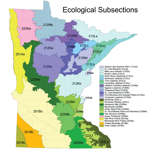
ECOREGIONS:
The Minnesota Department of Natural Resources uses the Ecological Classification System (ECS) developed by the U.S. Forest Service and Bailey. There are
four Provinces in Minnesota (Eastern Broadleaf Forest, Laurentian Mixed Forest, Prairie Parkland, and Tallgrass Aspen Parklands) and these are further
broken down into ten Sections and 26 Subsections.
SOURCE:
http://files.dnr.state.mn.us/natural_ resources/ecs/subsection.pdf
CONTACT:
Minnesota County Biological Survey Supervisor
MN Department of Natural Resources
500 Lafayette Road, Box 25
St. Paul, MN 55155
Phone: 651-259-5083
GRASSLAND EXAMPLES:
Two of the Provinces in Minnesota are primarily grasslands.
THE PRAIRIE PARKLAND PROVINCE, over 16 million acres in western Minnesota extending from Canada to the southern border with Iowa, coincides with the part
of the state historically dominated by tallgrass prairie (http://www.dnr.state.mn.us/ecs/251/index.html).
The TALLGRASS ASPEN PARKLANDS PROVINCE covers about 3 million acres of northwestern Minnesota (http://www.dnr.state.mn.us/ecs/223/index.html).
VISIT A PRESERVE
In addition to Department of Natural Resource preserves called Scientific and Natural Areas (SNAs), the Nature Conservancy (TNC) manages preserves in
all 50 States and in more than 30 countries. These protected lands include some of the best remnants of plant communities of grasslands, wetlands and
woodlands for your information. TNC is the leading conservation organization working to protect ecologically important lands and waters for nature and
people.
Locate and visit a preserve near you to see adapted native plant associations to inform your own project site decisions. Use the preserves inventory list
as your shopping list to match plant species to your planting project.
To access TNC preserve data as a source for Google Maps, or as a layer for Google Earth, you can use their feed url --
http://www.nature.org/placesweprotect/preserve-map.xml.
MISSOURI ECOREGIONS
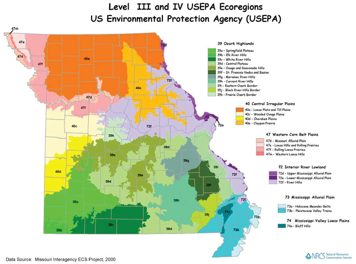
ECOREGIONS:
Missouri has six Level III ecoregions following the designations of Omernik. These ecoregions are: 39 Ozark Highlands; 40 Central Irregular Plains; 47
Western Corn Belt Plains; 72 Interior River Lowland; 73 Mississippi Alluvial Plain; and 74 Mississippi Valley Loess Plain. Information on the ecoregions
and on Missouri Ecoregion Mapping is available at the site listed under Source.
SOURCE:
Natural Resources Conservation Service (NRCS) Missouri web site at https://www.nrcs.usda.gov/wps/portal/nrcs/site/mo/home/ has a link to their ecoregion map.
CONTACT:
Missouri Department of Conservation,Conservation Headquarters
2901 W. Truman Blvd.
Jefferson City, MO, 65109
Phone: 573-751-4115
Fax: 573-751-4467
GRASSLAND EXAMPLES:
The Osage Prairie Conservation Area is a 1,500-acre upland prairie located in Vernon County that contains stretches of three streams and features diverse
flora and fauna. The prairie is located six miles south of Nevada, Missouri on Hwy. 71. Go 5 miles west on an unnamed gravel road (marked with a sign),
then 0.5 mile south on another unnamed road. This and other prairies are described in “Public Prairies of Missouri”, 2003, Missouri Dept.
of Conservation, P.O. Box 180 Jefferson City, MO 65102. Online at https://mdc.mo.gov/.
VISIT A PRESERVE
In addition to Department of Natural Resource preserves called Scientific and Natural Areas (SNAs), the Nature Conservancy (TNC) manages preserves in
all 50 States and in more than 30 countries. These protected lands include some of the best remnants of plant communities of grasslands, wetlands and
woodlands for your information. TNC is the leading conservation organization working to protect ecologically important lands and waters for nature and
people.
Locate and visit a preserve near you to see adapted native plant associations to inform your own project site decisions. Use the preserves inventory list
as your shopping list to match plant species to your planting project.
To access TNC preserve data as a source for Google Maps, or as a layer for Google Earth, you can use their feed url --
http://www.nature.org/placesweprotect/preserve-map.xml.
MISSISSIPPI ECOREGIONS
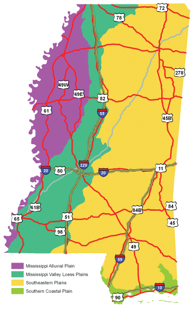
ECOREGIONS:
Mississippi has four Level III ecoregions which follow the designations by Omernik. These ecoregions are: Mississippi Alluvial Plain; Mississippi Valley
Loess Plains; Southeastern Plains, and Southern Coastal Plain. Each Level III ecoregion has Level IV ecoregions within it. Descriptions of the ecoregions
are available at https://www.epa.gov/eco-research/level-iii-and-iv-ecoregions-continental-united-states
SOURCE:
Mississippi Natural Heritage Program
CONTACT:
Plant Materials Center USDA-NRCS
2533 County Rd. 65
Coffeeville, MS 38922-2652
Phone: 662-675-2588
Fax: 662-675-2369
Web site: https://www.nrcs.usda.gov/plant-materials/pmc
GRASSLAND EXAMPLE:
The USDA-NRCS Plant Materials Center in Coffeeville has a publicly-accessible native grassland. They have done significant work on native grassland establishment
and can provide roadside vegetation managers with an abundance of useful information. Location and contact information is listed above under Contact.
VISIT A PRESERVE
In addition to Department of Natural Resource preserves called Scientific and Natural Areas (SNAs), the Nature Conservancy (TNC) manages preserves in
all 50 States and in more than 30 countries. These protected lands include some of the best remnants of plant communities of grasslands, wetlands and
woodlands for your information. TNC is the leading conservation organization working to protect ecologically important lands and waters for nature and
people.
Locate and visit a preserve near you to see adapted native plant associations to inform your own project site decisions. Use the preserves inventory list
as your shopping list to match plant species to your planting project.
To access TNC preserve data as a source for Google Maps, or as a layer for Google Earth, you can use their feed url --
http://www.nature.org/placesweprotect/preserve-map.xml.
MONTANA ECOREGIONS
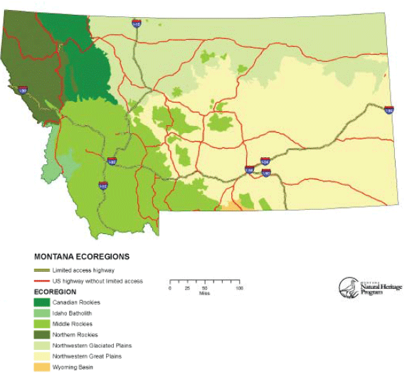
ECOREGIONS:
Montana has seven Level III ecoregions following the designations by Omernik. These ecogregions include Canadian Rockies; Middle Rockies; Northern Rockies;
Idaho Batholith; Northwest Glaciated Plains; Northwest Great Plains; and Wyoming Basin. Descriptions of each region can be found at
https://www.epa.gov/eco-research/level-iii-and-iv-ecoregions-continental-united-states
SOURCE:
Montana Natural Heritage Program www.mtnhp.org.
CONTACT:
Montana Natural Heritage Program
1515 E. 6th Avenue
Helena, MT 59620
Phone: 406-444-5354
Email: mtnhp@mt.gov
GRASSLAND EXAMPLE:
Dancing Prairie Preserve, a Nature Conservancy trust land, consists of 600+ acres of fescue-wheatgrass-needlegrass grasslands in rolling glacial hills.
The western Motana grasslands are transitional between the Palouse Prairie, which is more typical of eastern Washington and Oregon, and the grasslands
of the Northern Great Plains. A Montana Species of Concern, Spaling’s campion (Silene spaldingi), occurs on more mesic sites such as cool slopes,
small draws and swales at the Preserve. Directions: From Eureka, Montana, take Highway 93 north to MT 37, then take MT 37 west for about one mile to Airport
Road. The Preserve is about two miles north on Airport Road.
http://www.nature.org/ourinitiatives/regions/northamerica/unitedstates/mon-tana/placesweprotect/dancing-prairie-preserve.xml
VISIT A PRESERVE
In addition to Department of Natural Resource preserves called Scientific and Natural Areas (SNAs), the Nature Conservancy (TNC) manages preserves in
all 50 States and in more than 30 countries. These protected lands include some of the best remnants of plant communities of grasslands, wetlands and
woodlands for your information. TNC is the leading conservation organization working to protect ecologically important lands and waters for nature and
people.
Locate and visit a preserve near you to see adapted native plant associations to inform your own project site decisions. Use the preserves inventory list
as your shopping list to match plant species to your planting project.
To access TNC preserve data as a source for Google Maps, or as a layer for Google Earth, you can use their feed url --
http://www.nature.org/placesweprotect/preserve-map.xml.
NEBRASKA ECOREGIONS
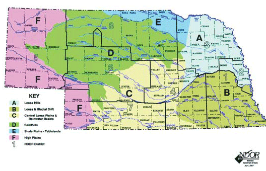
ECOREGIONS:
Nebraska has six ecoregions primarily following the designations by Omernik with modifications based on Bailey and the USGS. These ecoregions include
Loess Hills; Loess and Glacial Drift; Central Loess Plains and Rainwater Basins; Sandhills; Shale Plains-Tablelands; and High Plains.
SOURCE:
Nebraska Department of Roads, Plan for the Roadside Environment, June 2008, NDOR Landscape Plan Committee, online at
http://www.nebraskatransportation.org/environment/guides/roadside-plan/revision/road-env-plan-total.pdf.
CONTACT:
Nebraska Natural Heritage Program
Nebraska Game and Parks Commission
1703 L. St.,
Aurora, NE 68818
Phone: 402-471-0641
http://outdoornebraska.gov/naturalheritageprogram/
GRASSLAND EXAMPLE:
The Nine Mile Prairie is located northwest of the Lincoln Municipal Airport on West Fletcher Avenue in Lincoln. This 140 acre tallgrass prairie is one
of the largest areas of original tallgrass prairie in the state of Nebraska. The prairie is managed by the University of Nebraska-Lincoln which conducts
regular prescribed burns. http://snr.unl.edu/aboutus/where/fieldsites/ninemileprairie.asp
VISIT A PRESERVE
In addition to Department of Natural Resource preserves called Scientific and Natural Areas (SNAs), the Nature Conservancy (TNC) manages preserves in
all 50 States and in more than 30 countries. These protected lands include some of the best remnants of plant communities of grasslands, wetlands and
woodlands for your information. TNC is the leading conservation organization working to protect ecologically important lands and waters for nature and
people.
Locate and visit a preserve near you to see adapted native plant associations to inform your own project site decisions. Use the preserves inventory list
as your shopping list to match plant species to your planting project.
To access TNC preserve data as a source for Google Maps, or as a layer for Google Earth, you can use their feed url --
http://www.nature.org/placesweprotect/preserve-map.xml.
NEVADA ECOREGIONS
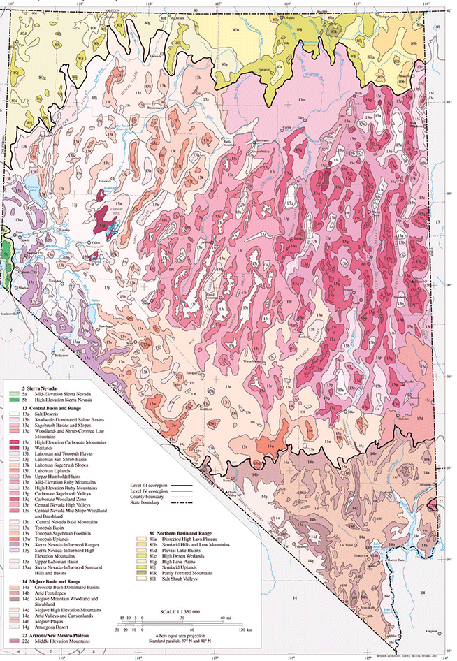
ECOREGIONS:
Nevada has four Level III ecoregions following the designations by Omernik. The ecoregions are: the Northern Basin and Range; Sierra Nevada; Mojave Basin
and Range; and Central Basin and Range. Descriptions of the ecoregions are available at https://gaftp.epa.gov/EPADataCommons/ORD/Ecoregions/nv/nv_front.pdf
and https://www.epa.gov/eco-research/level-iii-and-iv-ecoregions-continental-united-states.
SOURCE:
Nevada Fish & Wildlife Office of the U.S. Fish and Wildlife Service
http://www.fws.gov/nevada/habitats/documents/na_eco.pdf
CONTACT:
Department of Conservation & Natural Resources
Nevada Natural Heritage
Program Richard H. Bryan Building
901 South Stewart Street, Suite 5002
Carson City, NV 89701-5245
Phone: 775-684-2902 or 2900
Web site: http://heritage.nv.gov
GRASSLAND EXAMPLES:
SPRING VALLEY STATE PARK http://www.parks.nv.gov/sv.htm, at the headwaters of Meadow Valley Wash, Lincoln
Co. in east-central Nevada, has remnant native grass species, including: basin wildrye (Leymus cinerus); big galleta (Pleuraphis rigida); blue grama (Bouteloua
gracilis); galleta grass (Pleuraphis jamesii); Indian ricegrass (Achnatherum hymenoides); needle and thread (Hesperostipa comata);
sand dropseed (Sporabolus cryptandrus); sandberg bluegrass (Poa secunda); and sideoats grama (Bouteloua curtipendula).
OWYHEE PLATEAU, located in Elko County, has remnants of Alkali Sagebrush (Artemisia arbuscula ssp. Longiloba) / Curly Bluegrass (Poa secunda)
Shrub Herbaceous Vegetation. This short shrub steppe association is found between 4750-8530 feet elevation in northeastern Nevada. It is located on gentle
to moderate slopes or rolling uplands, ridges, alluvial fans, and basin bottoms on most aspects. Soils tend to be a heavy clay loam. Artemisia arbuscula
ssp. longiloba dominates the shrub overstory.
VISIT A PRESERVE
In addition to Department of Natural Resource preserves called Scientific and Natural Areas (SNAs), the Nature Conservancy (TNC) manages preserves in
all 50 States and in more than 30 countries. These protected lands include some of the best remnants of plant communities of grasslands, wetlands and
woodlands for your information. TNC is the leading conservation organization working to protect ecologically important lands and waters for nature and
people.
Locate and visit a preserve near you to see adapted native plant associations to inform your own project site decisions. Use the preserves inventory list
as your shopping list to match plant species to your planting project.
To access TNC preserve data as a source for Google Maps, or as a layer for Google Earth, you can use their feed url --
http://www.nature.org/placesweprotect/preserve-map.xml.
NEW HAMPSHIRE ECOREGIONS
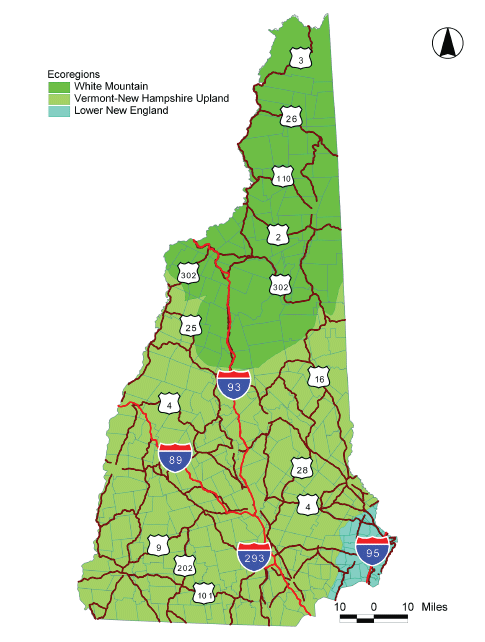
ECOREGIONS:
Three ecoregions have been defined in New Hampshire based on climate, landforms, and soils: (1) the Lower New England section, (2) the Vermont-New Hampshire
Upland section, and (3) the White Mountain section.
SOURCE:
New Hampshire Natural Heritage Bureau http://www.nhdfl.org/library/pdf/Natural%20Heritage/WebVersion_Tech%20Manual.pdf
CONTACT:
NH Natural Heritage Bureau
PO Box 1856
Concord, NH 03302-1856
Phone: 603-271-2214
GRASSLAND EXAMPLE:
New Hampshire is the second-most forested state in the U.S., and has few if any well-defined grassland natural communities. Most current grasslands are
of anthropogenic origin, e.g. pastures and the margins of airports. In the 1800s, forests converted to sheep pastures covered most of New Hampshire, so
grassland plant species have a long history in the state. Many native species do exist, often specializing as early-successional colonizers. Using native
species in roadside plantings will help conserve New Hampshire’s biodiversity. Native and naturalized species are identified in “Vascular Plants
of New Hampshire” (
http://www.nhdfl.org/library/pdf/w_flora.pdf).
VISIT A PRESERVE
In addition to Department of Natural Resource preserves called Scientific and Natural Areas (SNAs), the Nature Conservancy (TNC) manages preserves in
all 50 States and in more than 30 countries. These protected lands include some of the best remnants of plant communities of grasslands, wetlands and
woodlands for your information. TNC is the leading conservation organization working to protect ecologically important lands and waters for nature and
people.
Locate and visit a preserve near you to see adapted native plant associations to inform your own project site decisions. Use the preserves inventory list
as your shopping list to match plant species to your planting project.
To access TNC preserve data as a source for Google Maps, or as a layer for Google Earth, you can use their feed url --
http://www.nature.org/placesweprotect/preserve-map.xml.
NEW JERSEY ECOREGIONS
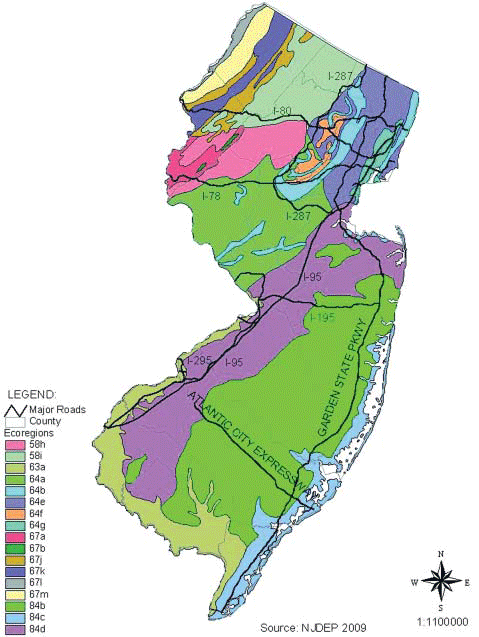
ECOREGIONS:
New Jersey has five Level III ecoregions following the designations by Omernik. These ecoregions include: 67 Valley and Ridge; 58 Highlands; 64 Piedmont;
63 Coastal Plain, and 84 Atlantic Coastal Pine Barrens. Descriptions of these ecoregions and of the Level IV ecoregions within each Level III ecoregion
can be found at the URL listed under Source.
SOURCE:
Woods, A.J., J.M. Omernik, B.C. Moran. 2007. Level III and IV Ecoregions of New Jersey. U.S. Environmental Protection Agency, Western Ecology Division,
Report EPA/CR-831682-01, 19p. https://www.epa.gov/eco-research/level-iii-and-iv-ecoregions-continental-united-states
CONTACT:
NJ Natural Heritage Program
Office of Natural Lands Management
PO Box 404
Trenton, NJ 08625-0405
Phone: 609-984-1339
GRASSLAND EXAMPLES:
The only extensive native (upland) grasslands in New Jersey occur on coastal dunes, e.g. Sandy Hook in Monmouth County, New Jersey. Numerous old fields
with abundant native and non-native grasses occur statewide on formerly forested land. For more information on successional upland grassland habitats
in the state see the book: Collins, B.R. and K. H. Anderson. 1994. Plant Communities of New Jersey: A Study in Landscape Diversity. Rutgers University
Press, New Brunswick, NJ. 287p.
VISIT A PRESERVE
In addition to Department of Natural Resource preserves called Scientific and Natural Areas (SNAs), the Nature Conservancy (TNC) manages preserves in
all 50 States and in more than 30 countries. These protected lands include some of the best remnants of plant communities of grasslands, wetlands and
woodlands for your information. TNC is the leading conservation organization working to protect ecologically important lands and waters for nature and
people.
Locate and visit a preserve near you to see adapted native plant associations to inform your own project site decisions. Use the preserves inventory list
as your shopping list to match plant species to your planting project.
To access TNC preserve data as a source for Google Maps, or as a layer for Google Earth, you can use their feed url --
http://www.nature.org/placesweprotect/preserve-map.xml.
NEW MEXICO ECOREGIONS
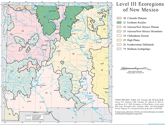
ECOREGIONS:
New Mexico has eight major ecoregions following EPA/Omernik’s classification system. These ecoregions are shown in the NM map at
https://www.epa.gov/eco-research/level-iii-and-iv-ecoregions-continental-united-states. These eight ecoregions include: 23 Arizona/New Mexico Mountains, 22 Arizona/New
Mexico Plateau, 24 Chihuahuan Deserts, 20 Colorado Plateau, 79 Madrean Archipelago, 21 Southern Rockies, 26 Southwestern Tablelands, and 25 Western High
Plains.
SOURCE:
Griffith, G.E., Omernik, J.M., McGraw, M.M., Jacobi, G.Z., Canavan, C.M., Schrader, T.S., Mercer, D., Hill, R., and Moran, B.C., 2006, Ecoregions of New
Mexico (color poster with map, descriptive text, summary tables, and photographs): Reston, Virginia, U.S. Geological Survey (map scale 1:1,400,000).
CONTACT:
Natural Heritage New Mexico
UNM Biology Dept.
MSC03 2020
1 University of New Mexico
Albuquerque NM 87131-0001
Phone: 505-277-3822
Fax: 505-277-3844
Email: nhnm@unm.edu
GRASSLAND EXAMPLES:
Located 7.5 miles south of Birchfield on Rt. 338 in Hidalgo County, the Gray Ranch may be the best example of nearly original grasslands in New Mexico.
While the ranch has been grazed, it has relatively intact examples of Bouteloua eriopoda (black grama) grassland, Sporobolis wrightii
(giant sacaton grass), and a very limited Bouteloua gracilis (blue grama) / Bouteloua dactyloides (buffalograss) grassland in the
Fitzpatrick pasture area.
VISIT A PRESERVE
In addition to Department of Natural Resource preserves called Scientific and Natural Areas (SNAs), the Nature Conservancy (TNC) manages preserves in
all 50 States and in more than 30 countries. These protected lands include some of the best remnants of plant communities of grasslands, wetlands and
woodlands for your information. TNC is the leading conservation organization working to protect ecologically important lands and waters for nature and
people.
Locate and visit a preserve near you to see adapted native plant associations to inform your own project site decisions. Use the preserves inventory list
as your shopping list to match plant species to your planting project.
To access TNC preserve data as a source for Google Maps, or as a layer for Google Earth, you can use their feed url --
http://www.nature.org/placesweprotect/preserve-map.xml.
NEW YORK ECOREGIONS
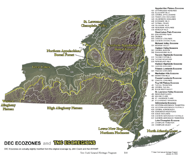
ECOREGIONS:
The ecoregional map shown here is the version developed by The Nature Conservancy following designations by the US Forest Service and Bailey. There are
seven ecoregions and 34 ecoregion subsections in New York. The Ecozone map of New York can be downloaded from
http://www.dec.ny.gov/maps/ecozonelink.kmz and viewed using Google Maps©.
SOURCE:
New York Natural Heritage Program, New York State DEC. http://www.dec.ny.gov/animals/29338.html
CONTACT:
New York Natural Heritage Program
NY DEC Central Office
625 Broadway, 5th Floor
Albany, NY 12233-4757
Phone: 518-402-8545
Go to http://www.dec.ny.gov/24.html and locate your Regional Office for their contact information.
GRASSLAND EXAMPLES:
Grassland communities can be located using the New York State Department of Environmental Conservation’s online biodiversity information search tool,
New York Nature Explorer. Land managers, planners, consultants, and project developers can identify a specific area and search for grassland communities
in that area. The New York Nature Explorer is online at http://www.dec.ny.gov/animals/57844.html.
VISIT A PRESERVE
In addition to Department of Natural Resource preserves called Scientific and Natural Areas (SNAs), the Nature Conservancy (TNC) manages preserves in
all 50 States and in more than 30 countries. These protected lands include some of the best remnants of plant communities of grasslands, wetlands and
woodlands for your information. TNC is the leading conservation organization working to protect ecologically important lands and waters for nature and
people.
Locate and visit a preserve near you to see adapted native plant associations to inform your own project site decisions. Use the preserves inventory list
as your shopping list to match plant species to your planting project.
To access TNC preserve data as a source for Google Maps, or as a layer for Google Earth, you can use their feed url --
http://www.nature.org/placesweprotect/preserve-map.xml.
NORTH CAROLINA ECOREGIONS
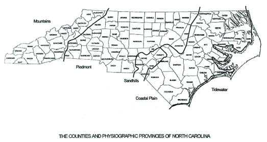
ECOREGIONS:
North Carolina has four physiographic provinces, including: Tidewater; Coastal Plain; Piedmont; and Mountains.
SOURCE:
North Carolina Natural Heritage Program. 2008. North Carolina
Department of Environment and Natural
Resources, Raleigh, NC.
CONTACT:
NC Natural Heritage Program
1601 MSC
Raleigh, NC 27699-1601
www.ncnhp.org
GRASSLAND EXAMPLE:
MCDOWELL PRAIRIE in southwestern Mecklenburg County has a good assemblage of grasses common in the Piedmont of NC with a mix of native grasses and forbs
that can educate and inspire roadside vegetation managers. http://www.charmeck.org/Departments/Park+and+Rec/Home.htm
SHUFFLETOWN PRAIRIE Nature Preserve, also in Mecklenburg County, is just 18 acres in size but may be the best Piedmont Prairie remnant in the Carolinas.
http://charmeck.org/mecklenburg/county/ParkandRec/StewardshipServices/NaturePreserves/pages/shuffletown%20prairie.aspx
USEFUL REFERENCES:
Native Grassland/Woodland Plant Communities. Schafale, M.P., and A.S. Weakley. 1990. Classification of the natural communities of North Carolina: third
approximation. NC NHP, NC Dept. of Environment, Health and Natural Resources, Raleigh.
http://www.ncnhp.org/Images/Other%20Publications/class.pdf
VISIT A PRESERVE
In addition to Department of Natural Resource preserves called Scientific and Natural Areas (SNAs), the Nature Conservancy (TNC) manages preserves in
all 50 States and in more than 30 countries. These protected lands include some of the best remnants of plant communities of grasslands, wetlands and
woodlands for your information. TNC is the leading conservation organization working to protect ecologically important lands and waters for nature and
people.
Locate and visit a preserve near you to see adapted native plant associations to inform your own project site decisions. Use the preserves inventory list
as your shopping list to match plant species to your planting project.
To access TNC preserve data as a source for Google Maps, or as a layer for Google Earth, you can use their feed url --
http://www.nature.org/placesweprotect/preserve-map.xml.
NORTH DAKOTA ECOREGIONS
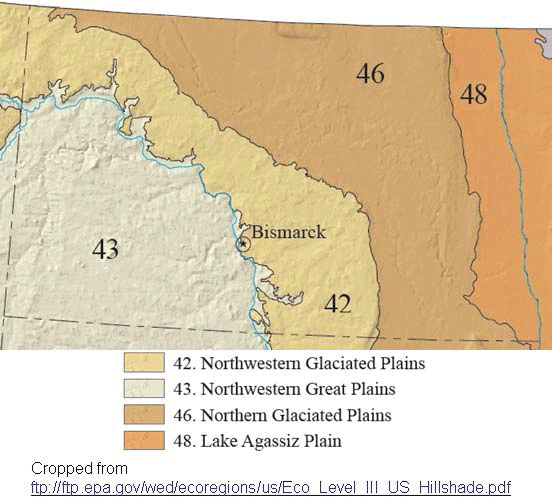
ECOREGIONS:
North Dakota has four Level III ecoregions, including: Northwestern Glaciated Plains; Northwestern Great Plains; Northern Glaciated Plains; and Lake Agassiz
Plain. Descriptions can be found at https://www.epa.gov/eco-research/level-iii-and-iv-ecoregions-continental-united-states.
SOURCE:
Bryce, Sandra. James M. Omernik, David E. Pater, Michael Ulmer, Jerome Schaar, Jerry Freeouf, Rex Johnson, Pat Kuck, and Sandra H. Azevedo. 1998. Ecoregions
of North Dakota and South Dakota. Jamestown, ND: Northern Prairie Wildlife Research Center Online. https://www.npwrc.usgs.gov/ (Version 30NOV1998).
CONTACT:
Natural Resource Program Natural Areas Registry/Natural Heritage Inventory North Dakota Parks and Recreation Department
1600 East Century Ave. Suite 3
Bismarck, ND 58503
Phone: 701-328-5370
Web site: https://www.parkrec.nd.gov/
GRASSLAND EXAMPLES:
North Dakota currently has five designated State nature preserves that are owned either by various state agencies or by private groups such as The Nature
Conservancy. Information on each preserve is available at https://www.parkrec.nd.gov/.
Dedicated State nature preserves include: Cross Ranch State Nature Preserve; Gunlogson State Nature Preserve; Head of the Mountain State Nature Preserve;
H.R. Morgan State Nature Preserve; and Sentinel Butte State Nature Preserve.
VISIT A PRESERVE
In addition to Department of Natural Resource preserves called Scientific and Natural Areas (SNAs), the Nature Conservancy (TNC) manages preserves in
all 50 States and in more than 30 countries. These protected lands include some of the best remnants of plant communities of grasslands, wetlands and
woodlands for your information. TNC is the leading conservation organization working to protect ecologically important lands and waters for nature and
people.
Locate and visit a preserve near you to see adapted native plant associations to inform your own project site decisions. Use the preserves inventory list
as your shopping list to match plant species to your planting project.
To access TNC preserve data as a source for Google Maps, or as a layer for Google Earth, you can use their feed url --
http://www.nature.org/placesweprotect/preserve-map.xml.
OHIO ECOREGIONS
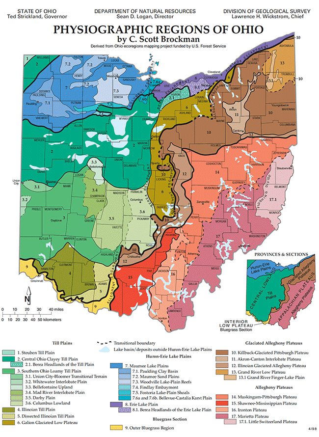
ECOREGIONS:
The Physiographic Regions of Ohio include: Appalachian Highlands (Appalachian Plateaus); Interior Plains (Interior Low Plateaus, Central Lowland). These
Major Divisions and Provinces regions are further divided into Sections. Descriptions of these regions are available at the URL listed under Source.
SOURCE:
The Physiographic Regions of Ohio, as described by C. Scott Brockman (derived from Ohio ecoregions mapping project funded by the U.S. Forest Service),
are presented at
http://www.dnr.state.oh.us/Portals/10/pdf/physio.pdf.
CONTACT:
Ohio Natural Heritage Program
Division of Natural Areas & Preserves
OH DNR
2045 Morse Road, Bldg. F
Columbus, OH 43229
Phone: 614-265-6561
GRASSLAND EXAMPLES: Information on presettlement prairies in Ohio can be found at the web site of the Ohio Prairie Association
http://www.ohioprairie.org/ (Click on “The Prairie Regions of Ohio” link). According to the web site, Ohio has seven Prairie Regions.
Three of these regions still have large presettlement prairies. These Prairie Regions, the Lake Plains Prairie, Central Till Plain Prairie, and the Southern
Till Plain Prairie, and the locations of their remaining original prairies are shown at the link above.
VISIT A PRESERVE
In addition to Department of Natural Resource preserves called Scientific and Natural Areas (SNAs), the Nature Conservancy (TNC) manages preserves in
all 50 States and in more than 30 countries. These protected lands include some of the best remnants of plant communities of grasslands, wetlands and
woodlands for your information. TNC is the leading conservation organization working to protect ecologically important lands and waters for nature and
people.
Locate and visit a preserve near you to see adapted native plant associations to inform your own project site decisions. Use the preserves inventory list
as your shopping list to match plant species to your planting project.
To access TNC preserve data as a source for Google Maps, or as a layer for Google Earth, you can use their feed url --
http://www.nature.org/placesweprotect/preserve-map.xml.
OKLAHOMA ECOREGIONS
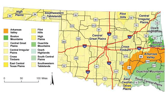
ECOREGIONS:
Oklahoma has 12 Level III ecoregions including Arkansas Valley, Boston Mountains, Central Great Plains, Central Irregular Plains, Cross Timbers, East
Central Texas Plains, Flint Hills, High Plains, Ouachita Mountains, Ozark Highlands, South Central Plains, and Southwestern Tablelands. Descriptions of
these ecoregions can be found at https://www.epa.gov/eco-research/level-iii-and-iv-ecoregions-continental-united-states.
SOURCE:
Map provided by Oklahoma Natural Heritage Inventory www.oknaturalheritage.ou.edu/
NHI CONTACT:
OK Natural Heritage Inventory / Dep. of Geography
Univ. of Oklahoma
111 East Chesapeake St.
Norman, OK 73019
Dept. of Geography Phone: 405-325-5325
www.geography.ou.edu
OK Vascular Plants Database:
www.oklahomaplantdatabase.org
Department of Geography:
www.geography.ou.edu
Oklahoma Vascular Plants Database:
www.oklahomaplantdatabase.org
GRASSLAND EXAMPLES:
TALLGRASS PRAIRIE:
Tallgrass Prairie Preserve, Osage Co.
http://www.nature.org/ourinitiatives/regions/northamerica/unitedstates/oklahoma/placesweprotect/tallgrass-prairie-preserve.xml
MIXEDGRASS PRAIRIES:
Cooper Wildlife Management Area, Woodward Co. http://www.travelok.com/listings/view.profile/id.12341
Four Canyon Preserve, Ellis Co. http://www.nature.org/wherewework/northamerica/states/oklahoma/preserves/four_canyon.html
Wichita Mountains National Wildlife Refuge, Comanche Co. http://www.fws.gov/refuge/wichita_mountains/
SHORTGRASS PRAIRIE:
Black Mesa State Park, Cimarron Co.
http://www.stateparks.com/black_mesa.html
OREGON ECOREGIONS
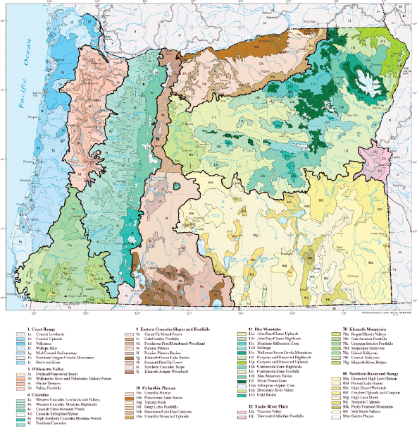
ECOREGIONS:
Oregon has nine Level III ecoregions following the Omernik designations. These ecoregions include: Coastal Range, Willamette Valley, Cascades, Eastern
Cascades Slopes and Foothills, Columbia Plateau, Blue Mountains, Snake River Plain, Klamath Mountains, Northern Basin and Range. Descriptions of each
ecoregion and of the Level IV ecoregions within each Level III ecoregion are at the URL listed under Source.
SOURCE:
Thorson, T.D., Bryce, S.A., Lammers, D.A., Woods, A.J., Omernik, J.M., Kagan, J., Pater, D.E., and Comstock, J.A., 2003. Ecoregions of Oregon (color poster
with map, descriptive text, summary tables, and photographs) Reston, Virginia, U.S. Geological Survey (map scale 1:1,500,000). https://www.epa.gov/eco-research/level-iii-and-iv-ecoregions-continental-united-states
CONTACT:
Oregon Natural Heritage Info. Center
1322 SE Morrison St.
Portland, OR 97214-2423
Phone: 503-725-9950
GRASSLAND EXAMPLE:
BOARDMAN GRASSLANDS PRESERVE Boardman Research Natural Area. DOD owned, located south of the Columbia River, in north central Oregon, 22,642 acres. Directions
and additional information can be found at
http://www.nature.org/ourinitiatives/regions/northamerica/unitedstates/oregon/placesweprotect/boardman-grasslands.xml.
VISIT A PRESERVE
In addition to Department of Natural Resource preserves called Scientific and Natural Areas (SNAs), the Nature Conservancy (TNC) manages preserves in
all 50 States and in more than 30 countries. These protected lands include some of the best remnants of plant communities of grasslands, wetlands and
woodlands for your information. TNC is the leading conservation organization working to protect ecologically important lands and waters for nature and
people.
Locate and visit a preserve near you to see adapted native plant associations to inform your own project site decisions. Use the preserves inventory list
as your shopping list to match plant species to your planting project.
To access TNC preserve data as a source for Google Maps, or as a layer for Google Earth, you can use their feed url --
http://www.nature.org/placesweprotect/preserve-map.xml.
PENNSYLVANIA ECOREGIONS
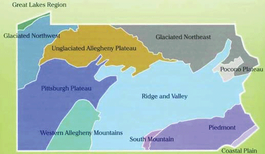
ECOREGIONS:
Pennsylvania has eleven ecoregions, following the designations by the US Forest Service and Bailey. These ecoregions (shown in the attached map) include:
Coastal Plain; Glaciated Northeast; Glaciated Northwest; Great Lakes Region; Piedmont; Pittsburgh Plateau; Pocono Plateau; Ridge and Valley; South Mountain;
Unglaciated Allegheny Plateau; and Western Allegheny Mountains.
SOURCE:
The map shown here is included in “Terrestrial & Palustrine Plant Communities of Pennsylvania” by Jean Fike, 1999, PA Natural Diversity
Inventory URL Both the book and map are available at: http://www.naturalheritage.state.pa.us/fikebook.aspx.
CONTACT:
Dept. of Conservation & Natural Resources
Rachel Carson State Office Building
PO Box 8552
Harrisburg, PA 17105-8552
http://www.naturalheritage.state.pa.us
GRASSLAND EXAMPLES:
Remnant native grasslands in Pennsylvania that can be examples for roadside vegetation managers are hard to find. Historically Pennsylvania was forested
following retreat of the glaciers. Forest openings of grassland were maintained by grazing herbivores and later by Native Peoples who used fire to maintain
the grasslands for hunting. A native grassland habitat appropriate for roadside revegetation projects may be the little bluestem - Pennsylvania sedge
opening habitat described on page 46 of “Terrestrial & Palustrine Plant Communities of Pennsylvania” by Jean Fike. This habitat can be
found over the entire Commonwealth and occurs on dry, acidic sites and include species such as
Schizachyrium scoparium (little bluestem),
Carex
pensylvanica (Pennsylvania sedge), Danthonia spicata (poverty grass),
Deschampsia flexuosa (common hairgrass),
C. communis
(a sedge),
Rubus flagellaris (prickly dewberry),
Lespedeza spp. (bushclovers), and less commonly,
Oryzopsis pungens (slender
mountain ricegrass).
VISIT A PRESERVE
In addition to Department of Natural Resource preserves called Scientific and Natural Areas (SNAs), the Nature Conservancy (TNC) manages preserves in
all 50 States and in more than 30 countries. These protected lands include some of the best remnants of plant communities of grasslands, wetlands and
woodlands for your information. TNC is the leading conservation organization working to protect ecologically important lands and waters for nature and
people.
Locate and visit a preserve near you to see adapted native plant associations to inform your own project site decisions. Use the preserves inventory list
as your shopping list to match plant species to your planting project.
To access TNC preserve data as a source for Google Maps, or as a layer for Google Earth, you can use their feed url --
http://www.nature.org/placesweprotect/preserve-map.xml.
RHODE ISLAND ECOREGIONS
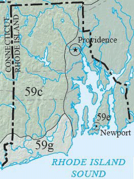
ECOREGIONS:
Rhode Island has two Level IV ecoregions, including: 59c Southern New England Coastal Plains and Hills; and 59e Narragansett / Bristol Lowland which are
both within the Level III Northeastern Coastal Zone (described at https://www.epa.gov/eco-research/level-iii-and-iv-ecoregions-continental-united-states).
SOURCE:
The Rhode Island ecoregions map is taken from the Level III and IV Ecoregions of New England map at https://www.epa.gov/eco-research/level-iii-and-iv-ecoregions-epa-region
CONTACTS:
Rhode Island Natural History Survey
P.O. Box 1858,
Kingston, RI 02881
Phone: 401-874-5800
Fax: 401-874-5868
www.rinhs.org
GRASSLAND EXAMPLES:
Descriptions of various grassland plant communities in Rhode Island have been compiled by the Rhode Island Conservation Stewardship Collaborative and
can be found in http://www.rinhs.org/wp-content/uploads/ricommclass.pdf
VISIT A PRESERVE
In addition to Department of Natural Resource preserves called Scientific and Natural Areas (SNAs), the Nature Conservancy (TNC) manages preserves in
all 50 States and in more than 30 countries. These protected lands include some of the best remnants of plant communities of grasslands, wetlands and
woodlands for your information. TNC is the leading conservation organization working to protect ecologically important lands and waters for nature and
people.
Locate and visit a preserve near you to see adapted native plant associations to inform your own project site decisions. Use the preserves inventory list
as your shopping list to match plant species to your planting project.
To access TNC preserve data as a source for Google Maps, or as a layer for Google Earth, you can use their feed url --
http://www.nature.org/placesweprotect/preserve-map.xml.
SOUTH CAROLINA ECOREGIONS
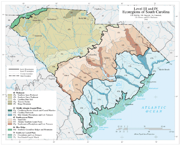
ECOREGIONS:
As shown in the attached map, South Carolina has 13 Level IV ecoregions following the designations by Omernik. These ecoregions include: Southern Inner
Piedmont; Southern Outer Piedmont; Carolina Slate Belt; Triassic Basins; Kings Mountain; Carolina Flatwoods; Mid-Atlantic Floodplains and Low Terraces;
Sand Hills; Atlantic Southern Loam Plains; Southeastern Floodplains and Low Terraces; Southern Crystalline Ridges and Mountains; Floodplains and Low Terraces;
and Sea Islands and Coastal Marsh.
SOURCE:
Griffith, G.E., Omernik, J.M., Comstock, J.A., Schafale, M.P., McNab, W.H., Lenat, D.R., MacPherson, T.F., Glover, J.B., and Shelburne, V.B., 2002, Ecoregions
of North Carolina and South Carolina, (color poster with map, descriptive text, summary tables, and photographs). Reston, Virginia, U.S. Geological
Survey (map scale 1:1,500,000). https://www.epa.gov/eco-research/level-iii-and-iv-ecoregions-continental-united-states
CONTACTS:
SC Dept. of Natural Resources
Heritage Trust Section
1000 Assembly Street
Columbia, SC 29201
Phone: 803-734-3893
GRASSLAND EXAMPLE:
AIKEN GOPHER TORTOISE HERITAGE PRESERVE in Aiken County supports a longleaf pine/wiregrass community. Prescribed burning creates favorable conditions
for wiregrass and many wildflowers, including passion flower, prickly pear, gopherweed, butterfly pea and polygonella.
VISIT A PRESERVE
In addition to Department of Natural Resource preserves called Scientific and Natural Areas (SNAs), the Nature Conservancy (TNC) manages preserves in
all 50 States and in more than 30 countries. These protected lands include some of the best remnants of plant communities of grasslands, wetlands and
woodlands for your information. TNC is the leading conservation organization working to protect ecologically important lands and waters for nature and
people.
Locate and visit a preserve near you to see adapted native plant associations to inform your own project site decisions. Use the preserves inventory list
as your shopping list to match plant species to your planting project.
To access TNC preserve data as a source for Google Maps, or as a layer for Google Earth, you can use their feed url --
http://www.nature.org/placesweprotect/preserve-map.xml.
SOUTH DAKOTA ECOREGIONS
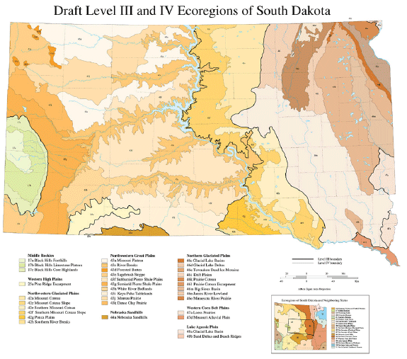
ECOREGIONS:
South Dakota has eight Level III ecoregions following the designations by Omernik. These ecoregions include: Middle Rockies; Western High Plains; Northwestern
Glaciated Plains; Northwestern Great Plains; Nebraska Sandhills; Northern Glaciated Plains; Western Corn Belt Plains; and Lake Agassiz Plain. These Level
III ecoregions and the further-subdivided Level IV ecoregions within each Level III ecoregion are described at the URL listed under Source.
SOURCE:
U.S. Environmental Protection Agency, Western Ecology Division (WED), https://www.epa.gov/eco-research/level-iii-and-iv-ecoregions-continental-united-states
CONTACT:
SD Dept. of Game, Fish & Parks
523 East Capitol Avenue
Pierre, SD 57501
Phone: 605-223-7660
Fax: 605-773-6245
Web site: http://gfp.sd.gov/
GRASSLAND SUGGESTIONS:
There are many types of native grassland in South Dakota. Roadside vegetation managers should determine which soil series are present in their project
area and consult the Natural Resources Conservation Service Ecological Site Description for those soil series. These Ecological Site Descriptions (formerly
called Range Site Descriptions) list the dominant native grasses and their proportions typically found in the different seral stages for each soil/ecological
site. Detailed County soil surveys are available for virtually all of South Dakota’s counties. Per David Ode, Personal Communication, Oct, 14, 2008. Relevant
web sites: Natural Resources Conservation Service (http://soils.usda.gov/), State Soil Surveys (http://soils.usda.gov/survey/printed_surveys/),
NRCS Ecological Site Information System (https://www.nrcs.usda.gov/resources/guides-and-instructions/national-ecological-site-handbook)
VISIT A PRESERVE
In addition to Department of Natural Resource preserves called Scientific and Natural Areas (SNAs), the Nature Conservancy (TNC) manages preserves in
all 50 States and in more than 30 countries. These protected lands include some of the best remnants of plant communities of grasslands, wetlands and
woodlands for your information. TNC is the leading conservation organization working to protect ecologically important lands and waters for nature and
people.
Locate and visit a preserve near you to see adapted native plant associations to inform your own project site decisions. Use the preserves inventory list
as your shopping list to match plant species to your planting project.
To access TNC preserve data as a source for Google Maps, or as a layer for Google Earth, you can use their feed url --
http://www.nature.org/placesweprotect/preserve-map.xml.
TENNESSEE ECOREGIONS
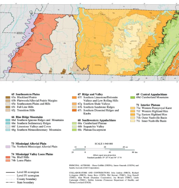
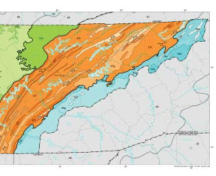
ECOREGIONS:
Tennessee has eight Level III ecoregions which follow the designations by Omernik. These ecoregions include: Southeastern Plains; Blue Ridge Mountains;
Ridge and Valley; Southwestern Appalachians; Central Appalachians; Interior Plateau; Mississippi Alluvial Plain; and Mississippi Valley Loess Plains.
Each ecoregion has Level IV ecoregions within it. Principal Authors: Glenn Griffith (USEPA), James Omernik (USEPA) and Sandra Azevedo (OAO Corporation).
Collaborators / Contributors: John Jenkins (NRCS), Richard Livingston (NRCS), James Keys (USFS); Phil Stewart (TDEC), Greg Russell (TDEC), Alan Woods
(Dynamac Corp.), Joy Broach (TDEC), Linda Cartwright (TDEC), Debbie Arnwine (TN Dept. of Health), and Thomas Loveland (USGS).
https://www.epa.gov/eco-research/level-iii-and-iv-ecoregions-continental-united-states
SOURCES:
PRINCIPAL AUTHORS: Glenn Griffith (USEPA), James Omernik (USEPA) and Sandra Azevedo (OAO Corporation). COLLABORATORS AND CONTRIBUTORS: (NRCS), James Keys
(USFS); Phil Stewart (TDEC), Greg Russell (TDEC), Alan Woods (Dynamac Corporation), Joy Broach (TDEC), Linda Cartwright (TDEC), Debbie Arnwine (Tennessee
Department of Health), and Thomas Loveland (USGS). https://www.epa.gov/eco-research/level-iii-and-iv-ecoregions-continental-united-states
CONTACT:
Natural Heritage Inventory Coordinator
TN Division of Natural Areas
401 Church St., Floor 7
Nashville, TN 37243-0447
Phone: 615-532-0431
GRASSLAND EXAMPLES:
Natural Areas in Tennessee with remnant grasslands include:
TEXAS NATURAL REGIONS
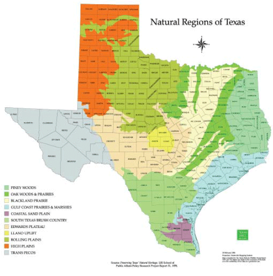
ECOREGIONS:
The twelve Natural Regions of Texas, shown in the accompanying map, include: Pineywoods; Oak Woods & Prairies; Blackland Prairie; Gulf Coastal Prairies
and Marshes; Coastal Sand Plain; South Texas Brush Country; Edward’s Plateau; Llano Uplift; Rolling Plains; High Plains; Trans Pecos; and Marine Environment.
SOURCE:
Preserving Texas Natural Heritage. LBJ School of Public Affairs Policy Research Project Report 31, 1978. Map compiled by Texas Parks and Wildlife Department
GIS Lab.
CONTACT:
Texas Parks and Wildlife Department
4200 Smith School Rd.
Austin, TX 78744
Phone: 800-792-1112
GRASSLAND EXAMPLES:
The Native Prairies Association of Texas (NPAT), a non-profit land trust dedicated to the conservation, restoration, and appreciation of native prairies,
savannas, and other grasslands in Texas, protects over 1200 acres of native Texas prairie. Information on the prairies is at
http://texasprairie.org/.
VISIT A PRESERVE
In addition to Department of Natural Resource preserves called Scientific and Natural Areas (SNAs), the Nature Conservancy (TNC) manages preserves in
all 50 States and in more than 30 countries. These protected lands include some of the best remnants of plant communities of grasslands, wetlands and
woodlands for your information. TNC is the leading conservation organization working to protect ecologically important lands and waters for nature and
people.
Locate and visit a preserve near you to see adapted native plant associations to inform your own project site decisions. Use the preserves inventory list
as your shopping list to match plant species to your planting project.
To access TNC preserve data as a source for Google Maps, or as a layer for Google Earth, you can use their feed url --
http://www.nature.org/placesweprotect/preserve-map.xml.
UTAH ECOREGIONS
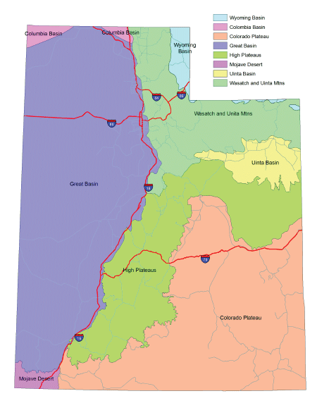
ECOREGIONS:
Six ecoregions come into Utah: The Great Basin, Colorado Plateau, High Plateaus and the Wasatch and Uinta Mountains cover most of the state, with smaller
areas of the Mojave Desert, Bonneville Basin and Colombia Basin ecoregions. The Uinta Basin is a part of the Colorado Plateau ecoregion, but usually referred
to as a separate geographic entity.
SOURCE:
Ecoregions of Utah, USGS map available at: DNR Map Store, 1594 W North Temple Street, Salt Lake City, Utah 84116.
CONTACT:
Utah Division of Wildlife Resources
Great Basin Research Center
494 West 100 South
Ephraim, Utah 84627
Phone: 435-283-4441
GRASSLAND EXAMPLES:
COLORADO PLATEAU ECOREGION: Highway 128, or the River Road, located just north of Moab along the Colorado River. This is a good example of Native grasses
along a highway, especially Sporobolus cyptandrus, or sand dropseed. GREAT BASIN ECOREGION: Golden Spike National Historic site, located west of Corinne.
Good examples of Bluebunch wheat grass (Pseudoreogneria spicata), and basin wild rye (Leymus cinereus) can be seen here
www.nps.gov/gosp/.
VISIT A PRESERVE
In addition to Department of Natural Resource preserves called Scientific and Natural Areas (SNAs), the Nature Conservancy (TNC) manages preserves in
all 50 States and in more than 30 countries. These protected lands include some of the best remnants of plant communities of grasslands, wetlands and
woodlands for your information. TNC is the leading conservation organization working to protect ecologically important lands and waters for nature and
people.
Locate and visit a preserve near you to see adapted native plant associations to inform your own project site decisions. Use the preserves inventory list
as your shopping list to match plant species to your planting project.
To access TNC preserve data as a source for Google Maps, or as a layer for Google Earth, you can use their feed url --
http://www.nature.org/placesweprotect/preserve-map.xml.
VERMONT ECOREGIONS
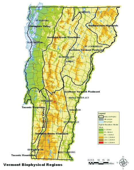
ECOREGIONS:
Vermont has eight Biophysical Regions which follow the designations by Bailey and The Nature Conservancy. These Biophysical Regions include: Champlain
Valley; Taconic Mountains; Vermont Valley; Northern Green Mountains; Southern Green Mountains; Northern Vermont Piedmont; Southern Vermont Piedmont; and
Northeastern Highlands.
SOURCE:
E.H. Thompson and E.R. Sorenson. 2000 and 2005. Wetland, Woodland, Wildland: A Guide to the Natural Communities of Vermont. Published by The
Nature Conservancy and Vermont Department of Fish and Wildlife, distributed by University Press of New England. Available online at
http://www.vtfishandwildlife.com/books.cfm?libbase_=Wetland,Woodland,Wildland.
CONTACT:
Nongame and Natural Heritage Program
Vermont Fish and Wildlife Department
5 Perry Street, Suite 40
Barre, Vermont 05641
Phone: 802-476-0199
Web site: http://www.vtfishandwildlife.com/wildlife_nongame.cfm
GRASSLAND SUGGESTIONS:
Vermont has very little natural grasslands and no natural prairies. Many grasslands are associated with agricultural lands which occur primarily in the
Champlain Valley. Natural grasslands are limited to very small areas along the shores of rivers (such as RIVERSHORE GRASSLAND) and Lake Champlain (LAKESHORE
GRASSLAND) and to emergent wetland natural community types, such as Sedge Meadow and Shallow Emergent Marsh, which are commonly associated with beaver
meadows. Descriptions of all Vermont’s natural community types and examples to visit are provided in the book Wetland, Woodland, Wildland (see reference
listed under Source).
VISIT A PRESERVE
In addition to Department of Natural Resource preserves called Scientific and Natural Areas (SNAs), the Nature Conservancy (TNC) manages preserves in
all 50 States and in more than 30 countries. These protected lands include some of the best remnants of plant communities of grasslands, wetlands and
woodlands for your information. TNC is the leading conservation organization working to protect ecologically important lands and waters for nature and
people.
Locate and visit a preserve near you to see adapted native plant associations to inform your own project site decisions. Use the preserves inventory list
as your shopping list to match plant species to your planting project.
To access TNC preserve data as a source for Google Maps, or as a layer for Google Earth, you can use their feed url --
http://www.nature.org/placesweprotect/preserve-map.xml.
VIRGINIA ECOREGIONS
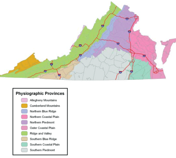
ECOREGIONS:
Virginia is divided into several physiographic provinces based on their geologic history. Each province is unique in topography, soil pH, soil depth,
elevation, availability of light, and hydrology. These characteristics all combine to influence the species of plants and animals found there. Virginia
is unique, encompassing parts of five of these provinces, and thus a greater variety of natural landscapes than any other eastern state.
SOURCE:
http://www.dcr.virginia.gov/natural_heritage/index.shtml
CONTACT:
Department of Conservation and Recreation
Natural Heritage Program
217 Governor Street, Suite 312
Richmond, VA 23219-2094
Phone: 804-786-7951
Fax: 804-371-2674
Website: http://www.dcr.virginia.gov
GRASSLAND SUGGESTIONS:
ADAPTED FROM “Native Plants for Conservation, Restoration, and Landscaping” http://www.dcr.virginia.gov/natural-heritage/nativeplants
GRASSLAND PLANT SPECIES (pg. 4): The six plant species that dominate most of Virginia’s upland successional grasslands are bunchgrass species including
big bluestem, little bluestem, bushy bluestem, broomsedge, Indian grass and switchgrass which have their growing season in the summer months. Wildflower
species found in these grasslands include blackeyed Susan, evening primrose and butterfly weed. For more information on species found in wetter areas,
such as seepages, pond edges and stream banks, see the DCR brochure “Native Plants for Conservation, Restoration and Landscaping - Riparian Forest
Buffers.”
VISIT A PRESERVE
In addition to Department of Natural Resource preserves called Scientific and Natural Areas (SNAs), the Nature Conservancy (TNC) manages preserves in
all 50 States and in more than 30 countries. These protected lands include some of the best remnants of plant communities of grasslands, wetlands and
woodlands for your information. TNC is the leading conservation organization working to protect ecologically important lands and waters for nature and
people.
Locate and visit a preserve near you to see adapted native plant associations to inform your own project site decisions. Use the preserves inventory list
as your shopping list to match plant species to your planting project.
To access TNC preserve data as a source for Google Maps, or as a layer for Google Earth, you can use their feed url --
http://www.nature.org/placesweprotect/preserve-map.xml.
WASHINGTON ECOREGIONS
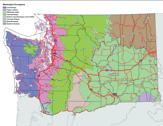
ECOREGIONS:
Washington State has portions of nine ecoregions within its borders. The ecoregions, which are adapted from Omernik and USEPA, are Northwest Coast; Puget
Trough; North Cascades; West Cascades; East Cascades; Okanogan; Canadian Rockies; Blue Mountains; and Columbia Plateau. The map is located at
https://ecology.wa.gov/.
SOURCE:
Raymond Willard, Landscape Architect, Roadside Maintenance Program Manager, Maintenance and Operations Division, Washington State Department of Transportation
https://wsdot.wa.gov/construction-planning/protecting-environment/maintaining-vegetation-along-our-highways/integrated-roadside-vegetation-management-plans
CONTACT:
Washington State Dept. of Natural Resources
Natural Heritage Program
P.O. Box 47014
Olympia, WA 98504-7014
Phone: 360-902-1000
Web site: https://www.dnr.wa.gov/natural-heritage-program
GRASSLAND EXAMPLE:
About two-thirds of eastern Washington was once covered with shrubsteppe or grassland prairie. However, most has been converted to agricultural and grazing
uses. Examples of grasslands in Natural Area Preserves located in each ecoregion of Washington are available at https://www.dnr.wa.gov/managed-lands.
VISIT A PRESERVE
In addition to Department of Natural Resource preserves called Scientific and Natural Areas (SNAs), the Nature Conservancy (TNC) manages preserves in
all 50 States and in more than 30 countries. These protected lands include some of the best remnants of plant communities of grasslands, wetlands and
woodlands for your information. TNC is the leading conservation organization working to protect ecologically important lands and waters for nature and
people.
Locate and visit a preserve near you to see adapted native plant associations to inform your own project site decisions. Use the preserves inventory list
as your shopping list to match plant species to your planting project.
To access TNC preserve data as a source for Google Maps, or as a layer for Google Earth, you can use their feed url --
http://www.nature.org/placesweprotect/preserve-map.xml.
WEST VIRGINIA ECOREGIONS
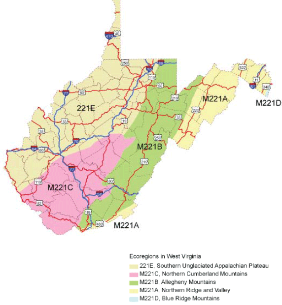
ECOREGIONS:
West Virginia has five major ecoregions which follow designations by Bailey and the USDA Forest Service. These ecoregions include: Southern Unglaciated
Appalachian Plateau; Northern Cumberland Mountains; Allegheny Mountains; Northern Ridge and Valley; and Blue Ridge Mountains.
SOURCE:
Ecoregion section boundaries are modified from: Bailey, R.G., P.E. Avers, T. King, and W.H. McNab, editors, 1994. Ecoregions and subregions of the United
States (map). U.S. Geological Survey, Washington, DC. Scale 1:7,500,000 colored. Accompanied by a supplementary table of map unit descriptions compiled
and edited by W.H. McNab and R.G. Bailey. Prepared for the USDA Forest Service.
CONTACT:
WV Div. of Natural Resources
Natural Heritage Program
Elkins Operations Center
PO Box 67,
Ellins, WV 26241
Phone: 304-637-0245
http://www.wvdnr.gov/wildlife/wdpintro.shtm
GRASSLAND SUGGESTIONS:
West Virginia is a mostly forested state and natural open habitats are rare, occurring mainly in areas with specialized disturbance regimes (e.g., flooding)
or harsh edaphic conditions (hot, dry aspects in the Ridge and Valley). Examples of these specialized plant communities at lower elevations include shale
barrens along Highway 55 east of Wardensville in Hampshire County and a river scour prairie along the Gauley River at Swiss (rafting take-out) in Nicholas
County. Open wetlands and heath/grassland communities at high elevations can be visited at Dolly Sods in Tucker County.
VISIT A PRESERVE
In addition to Department of Natural Resource preserves called Scientific and Natural Areas (SNAs), the Nature Conservancy (TNC) manages preserves in
all 50 States and in more than 30 countries. These protected lands include some of the best remnants of plant communities of grasslands, wetlands and
woodlands for your information. TNC is the leading conservation organization working to protect ecologically important lands and waters for nature and
people.
Locate and visit a preserve near you to see adapted native plant associations to inform your own project site decisions. Use the preserves inventory list
as your shopping list to match plant species to your planting project.
To access TNC preserve data as a source for Google Maps, or as a layer for Google Earth, you can use their feed url --
http://www.nature.org/placesweprotect/preserve-map.xml.
WISCONSIN ECOREGIONS
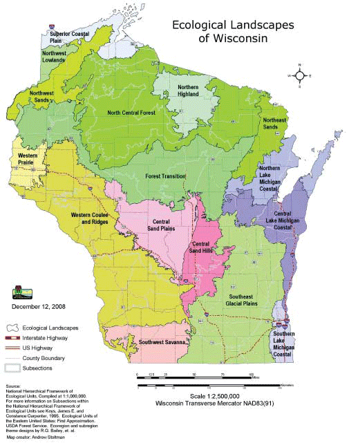
ECOREGIONS:
Wisconsin has 16 ecological landscapes which follow designations by Bailey and the USDA Forest Service. These ecological landscapes include: Southwest
Savanna; Southeast Glacial Plains; Southern Lake MI Coastal; Western Coulee and Ridges; Central Sand Plains; Central Sand Hills; Northern Lake MI Coastal;
Northeast Sands; Forest Transition; North Central Forest; Northern Highland; Northwest Sand; Northwest Lowlands; Superior Coastal Plain; Western Prairie;
and Central Lake Michigan Coastal.
SOURCE:
National Hierarchical Framework of Ecological Units. Compiled at 1:1,000,000. For more information on Subsections within the National Hierarchical Framework
of Ecological Units see: Keys, James E. and Constance Carpenter, 1995. Ecological Units of the Eastern United States: First Approximation. USDA
Forest Service. Ecoregion and subregion theme designs by R.G. Bailey, et. al. Map creator: Andrew Stoltman
CONTACT:
Natural Heritage Inventory Program Bureau of Endangered Resources Wisconsin
Department of Natural Resources
101 S. Webster St.
Madison, WI 53707-7921
Phone: 888-936-7463
Fax: 608-261-4380
Web site: http://dnr.wi.gov/topic/nhi/
GRASSLAND EXAMPLE:
Descriptions and locations of grassland communities within Wisconsin are available at
http://dnr.wi.gov/topic/EndangeredResources/.
VISIT A PRESERVE
In addition to Department of Natural Resource preserves called Scientific and Natural Areas (SNAs), the Nature Conservancy (TNC) manages preserves in
all 50 States and in more than 30 countries. These protected lands include some of the best remnants of plant communities of grasslands, wetlands and
woodlands for your information. TNC is the leading conservation organization working to protect ecologically important lands and waters for nature and
people.
Locate and visit a preserve near you to see adapted native plant associations to inform your own project site decisions. Use the preserves inventory list
as your shopping list to match plant species to your planting project.
To access TNC preserve data as a source for Google Maps, or as a layer for Google Earth, you can use their feed url --
http://www.nature.org/placesweprotect/preserve-map.xml.
WYOMING ECOREGIONS
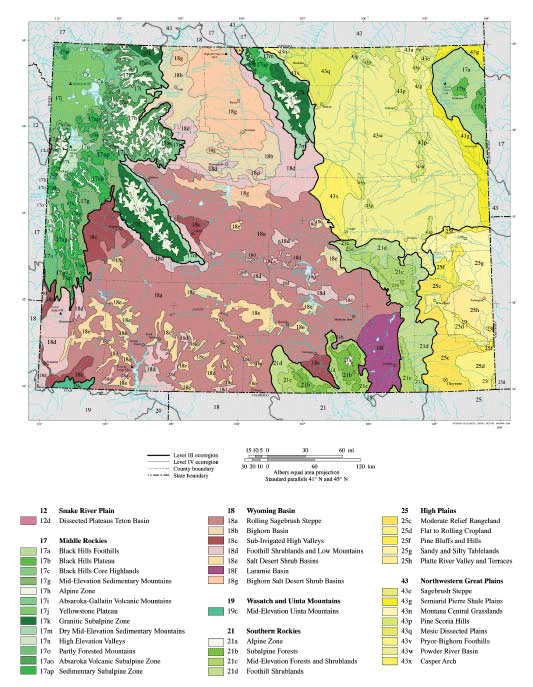
ECOREGIONS:
Wyoming has seven Level III ecoregions, which follow the Omernik designations. These ecoregions include: Snake River Plain; Middle Rockies; Wyoming Basin;
Wasatch and Uinta Mountains; Southern Rockies; High Plains; and Northwestern Great Plains. Each ecoregion has Level IV ecoregions within it. Both Level
III and IV ecoregions are shown in the attached map and described at https://www.epa.gov/eco-research/level-iii-and-iv-ecoregions-continental-united-states.
SOURCE:
Chapman, S.S., Bryce, S.A., Omernik, J.M., Despain, D.G., ZumBerge, J., and Conrad, M., 2004, Ecoregions of Wyoming (color poster with map, descriptive
text, summary tables, and photographs). Reston, Virginia, U.S. Geological Survey (map scale 1:1,400,000).
https://www.epa.gov/eco-research/level-iii-and-iv-ecoregions-continental-united-states
CONTACT:
University of Wyoming
Wyoming
Natural Diversity Database
Dept. 3381
1000 E. University Ave.
Laramie, WY 82071
Phone: 307-766-3026
Web site: http://uwadmnweb.uwyo.edu/wyndd/
GRASSLAND EXAMPLE:
Natural Resources Conservation Service specialists provided examples located near highways and rights- of-way (ROW). One example of a native prairie is
located just east of Upton on Hwy 16. The rest stop/roadside park on Sage Drive hasnative (not reclaimed) Calamovilfa longifolia (prairie
sandreed), Bouteloua gracilis (blue grama), Aristida purpurea var. longiseta (red three awn), Koeleria macrantha (prairie Junegrass),
Elymus trachycaulus (slender wheatgrass), Pascopyrum smithii (western wheatgrass), Thermopsis rhombifolia (prairie thermopsis),
Solidago spp. (goldenrod), and Liatris punctata (dotted gayfeather).
Reclaimed grasslands in Southwestern Wyoming include I-80 road ROW between Bridger Valley and Evanston (Little America vicinity) has some fine examples
of Leymus cinereus (basin wild rye). South Park Loop road ROW as it junctions with Hwy 189 through the town of Jackson has fine specimens of
Pseudoroegneria spicata (bluebunch wheatgrass) and basin wildrye.
Hwy 89 from Hoback Junction to Alpine Junction has recently had a lot of upgrades and WYDOT made a great effort to reclaim with all natives (a few smooth
brome might be seen here and there, however). Species that can be seen include Elymus lanceolatus (thickspike wheatgrass), slender wheatgrass, Bromus
marginatus (mountain brome), bluebunch wheatgrass, and basin wildrye. In particular, fine specimens can be found of mountain brome at the Big Kahuna overlook
and parking area.
Back to top
PART 3
APPLIED ECOLOGY: The Nebraska Model
INTRODUCTION
To the question, “why an ecological approach”, John L. Craig, Director of the Nebraska Department of Roads (NDOR) would likely answer: “The
result will be a transportation system that makes the manmade and natural environments compatible and sustainable.” And that is why we include the
following description of the NDORs use of ecoregions in design, planning and maintenance. This is a general model that is applicable in different regions
in different ways. “It is doubtful whether detailed standardization will ever be desirable, since variety and change are the essence of roadside
charm.” (Simonson, 1934).
Matching natural needs of the site with human needs of the project will result in a win-win product. In 2008, John Horsley, Executive Director of AASHTO
noted, “the American public demands projects that not only provide mobility, but also contribute to one’s overall quality of life.” The Nebraska
model is a well-reasoned place to begin.
References Cited:
AASHTO, 2008. Taking the High Road, The Environmental and Social Contributions of America’s Highway Programs. American Association of State Highway
and Transportation Officials, Washington DC.
Nebraska Department of Roads, 2009. http://www.dor.state.ne.us/environment/
Thompson, Art, 2009. Personal communication, Nebraska Department of Roads.
Back to top
CHAPTER 1
LANDSCAPE AND CORRIDOR OBJECTIVES
The highway corridors across Nebraska impact the lives of all our citizens and visitors on a daily basis. The Department’s mission is to provide a safe,
reliable, affordable, and environmentally compatible transportation system. This Plan will help guide the development of our highway roadsides. The result
will be a transportation system that makes the manmade and natural environments compatible and sustainable. In June of 2008, the NDOR Landscape Plan Committee
led by Art Thompson, submitted its thoughtful plan (Plan for the Roadside Environment) that connects the needs of transportation with the needs of the
environment of Nebraska. The State is divided into six ecoregions with unique landscapes. Five highway corridors types cross them all, each requiring
different landscape, construction and maintenance solutions. Here are some of the plan’s objectives:
- Incorporate the Nebraska Natural Legacy Project.
- Use for landscape and mitigation designs.
- Encourage other agencies’ cooperation and partnerships.
- Require environmental consultation at earliest stages of project.
- Provide a basis for NEPA analysis and guide design.
- Offer a common base of information for training supervisors.
- Promote increased use of native plantings.
- Provide sustainable, noxious weed controlled roadsides.
- Design the landscape as an integral part of good roadway design.
All of these objectives are to be accomplished in six landscape regions for six functional corridor types:
- Metropolitan
- Community Center
- Community Edge
- Rural Interstate /Expressway
- Rural Highway
- Scenic Corridor
LANSCAPE OBJECTIVES
- Stabilize the soil, prevent erosion, and protect roadway structures.
- Manage wildlife habitat and connect wildlife corridors.
- Minimize maintenance and increase efficiencies.
- Integrate the roadway corridor into the surrounding regional landscape.
- Display native vegetation and connect motorist to the regional landscape.
- Minimize construction and maintenance effects on biotic communities.
- Filter runoff pollutants to protect surface and ground waters.
Additional Corridor-Specific Objectives
- Storm water detention/ground water infiltration.
- Screen headlight glare.
- Control blowing snow and drifts.
- Accent informational signage.
- Screen distractions from off corridor.
- Frame views and help reduce highway hypnosis.
- Provide point of interest/identify community entry/improve way-finding.
- Provide and emergency hay bank for livestock.
- Guide traffic - indicate change in direction.
- Buffer vehicle noise from adjacent properties.
- Screen undesirable views to and from roadway.
- Separate pedestrian and/or bicycle traffic from vehicular traffic.
- Preserve existing views.
- Improve perception of roadway and traffic (estimating speed/distance, traffic calming and reduce traffic speed).
- Aesthetic enhancement.
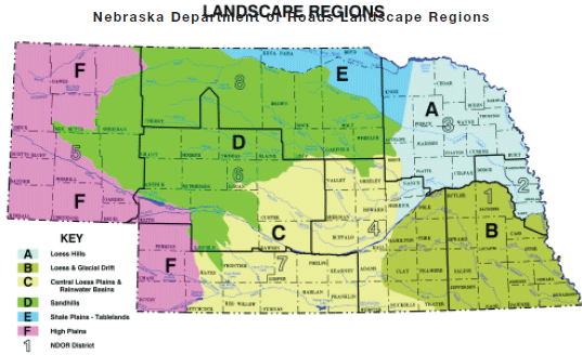
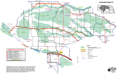
Back to top
CHAPTER 2
NEBRASKA REGION “D” EXAMPLE
REGION “D” DESCRIPTION
CLIMATE: This region is primarily within Zone 4b of the USDA PLant Materials Hardiness Zone Map with a range of annual minimum temperatures
of -20 to -25 degrees Fahrenheit. This semi-arid State ranges from 23 inches of rain in the east to less than 17 inches of rain in the west, annually.
LANDFORM: This region consists of a fragile sandy rangeland of undulating fields of grass-stabilized sand dunes, aligned in a northwesterly
to southeasterly direction. In the eastern edge, the dunes transition to flat sandy plains with meadows and marshes. A lake region of 2,000 small shallow
lakes exists in the north central portion. The west end of the Sandhills has a second area of small lakes that are moderate to highly alkaline.
GENERAL SOIL TYPES: Region “D” consists of sand with little organic matter. These soils are highly susceptible to wind erosion.
Clay lenses define the western wetlands.
HYDROLOGY: High infiltration rates, up to 10 feet per day, allow rainwater and snowmelt to percolate rapidly downward. Extensive aquifers,
up to 900 feet thick,have formed below the Sandhills in graveldeposits. The underground reservoir ispart of the Ogallala aquifer.
Rivers include the Niobrara, NorthPlatte, South Platte and the Snake. Aseries of smaller rivers rarely flood ordry out during drought. Wetland lakes and
marshes are small, shallow and less than 14 feet deep. Most lakes, marshes, and wet meadows are near neutral pH. Alkaline wetlands and lakes are common
in the west where salts and carbonates accumulate in soils. Some of the Great Plains’ largest fens are present in the Sandhills.
PLANT COMMUNITIES: The Sandhills contain plant communities ranging from wetlands to dry upland prairie. Many blowouts exist. The Sandhill
prairie dune community includes shortgrass, prairie grasses, and forbs. The Sandshills dry valley prairie between the dunes has a taller prairie community.
Wet sedge meadows and alkaline wet meadows exist in this region.
Native woodlands are uncommon and found only in fire-protected drier valleys and bluffs. Eastern cottonwood and willow dominate riparian woodlands. Small
shrubs and thickets of chokecherry, plum, sand cherry and snowberry are scattered over the dune prairies. In the northeast and central areas, many deciduous
windbreaks including cottonwood and eastern red cedar are common. The Niobrara River Valley contains eastern deciduous woodlands on south-facing bluffs.
Other disjunct communities exist here making this a “biological crossroads”.
Invasive plants include bromegrass, Canada thistle, leafy spurge and red cedar that threaten prairie remnants, pastures and roadsides. Phragmites, salt
cedar and Reed canarygrass threaten streams, rivers and wetlands. Protected plants include blowout penstemon, western prairie fringed orchid and small
white lady slipper orchid. Some ten beetles, reptiles, birds and otters are protected here.
BIOLOGICALLY UNIQUE LANDSCAPES AND HABITATS: These are areas of the state that have been identified as “key habitats” that
offer the highest likelihood that they will persist over the long term. These areas were selected based on known occurrences of ecological communities
and at-risk species and offer the best opportunity for conserving the full array of biological diversity in Nebraska. Disturbance to these areas should
be minimized. Habitat preservation in the landscape design is highly desirable. Opportunities to enhance and restore critical habitat should be considered.
SOCIOLOGICAL COMPONENTS: This region of grass stabilized sand dunes remains sparsely populated and in a relatively unspoiled natural
condition. It was considered a desert through the 1850’s when early ranchers discovered its rangeland potential. Center pivot irrigation in the 1970’s
was unsuccessful for large-scale crop production. Some 95% of the Sandhills is maintained as grasslands for livestock.
ECONOMIC FEATURES - Ranching is the primary economic activity. Nature-based tourism and recreation is expanding along rivers.
LAND USE - The area is dominated by grasslands for cattle production. Large amounts of public land exist in 3 wildlife refuges, 2 national
forests, State wildlife management areas and State parks.
MAJOR COMMUNITIES - include North Platte, Valentine, Bassett, Mullen, and Ainsworth.
TRANSPORTATION - In addition to major highways, the Burlington Northern Santa Fe and Nebkota Railways run through this region. Scenic
highways include: the Outlaw Tail, Sandhills Journey, Loup Rivers, and 385 Gold Rush Byways. The Cowboy Trail bike route runs from Gordon through Valentine,
exiting the Sandhills at Bassett.
CORRIDOR OBJECTIVES FOR LANDSCAPE REGION “D” - Landscape Region “D” contains a large number of Biologically Unique Landscapes that will influence construction and landscape treatments in
this corridor.
METROPOLITAN - This corridor type is not used in this region at this time.
COMMUNITY EDGE AND CENTER- Communities in this region are primarily smaller and have less defined edge and center areas. Traffic calming
and maintaining and enhancing the community’s identity are key.
RURAL INTERSTATE/EXPRESSWAY - Within Region “D” this corridor type runs parallel to the Platte River through the southern-most
portion of the region.
RURAL HIGHWAY - Much of the adjacent land is rangeland or pasture. Almost every highway in this corridor type goes through a biologically
unique landscape as shown on the map. This corridor is also important for wildlife as a passage between biologically unique habitats and secondarily as
habitat itself. However, in this region there is much less need of habitat since the adjacent land has often not been significantly altered. Techniques
to prevent monotony and control blowing snow are both very important in this region for this corridor type.
SCENIC CORRIDOR - Within Landscape Region “D” there are portions of 5 designated scenic highways. Each has a unique character
to maintain. The overriding objective is to preserve existing views and scenic qualities. All work should be in context with adjacent surroundings. Screening
of objectionable views and framing of special views is very important.
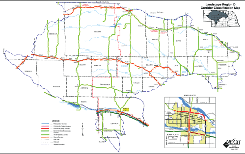
Back to top
CHAPTER 3
PLANT SPECIES MATCH OBJECTIVES
The listings to follow are recommendations of native species of plant material for use in the landscape region. This list is expected to broaden as the
demand for additional native species increases in the future. Micro-climates within Region “D” strongly influence appropriate locations for
shrubs and trees.
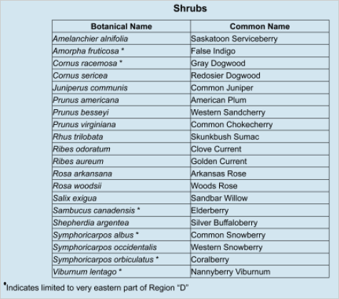
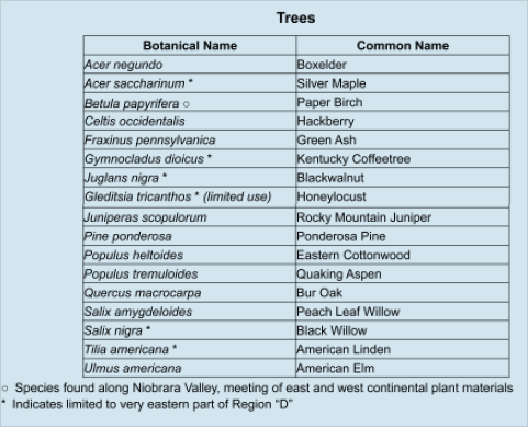
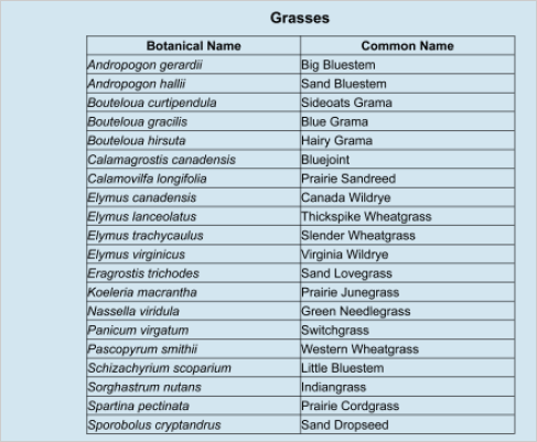

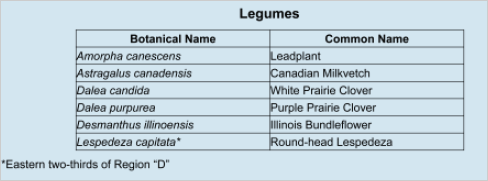
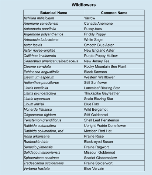
Back to top
PART 4
NATIVE PLANT ESTABLISHMENT
INTRODUCTION
Highway safety favors the use of grasses over trees in the right-of-way. Because native grasses require minimal maintenance compared to traditional sods,
native grassland species occurring naturally throughout the United States become a logical and affordable roadside cover.
Why are historic grasslands important? In short, they are problem solvers for landscape and maintenance goals or vegetation management
by many land agencies. Native grasslands historically occurred from coast to coast. Before European settlement, grasslands covered over 250,000,000 acres
of North America, including tall grass, mixed and short grass prairies. Most of this land was converted to agricultural use through grazing, cultivation,
and draining. Necessary fire suppression by settlers favored the replacement of grassland with forest species. Less than 1% of original grassland
cover remains.
What grasslands existed in my region? Precipitation is the limiting factor of these grasslands. The mixed grass and short grass prairies
of the Dakotas and Colorado are dominated by warm season grasses. The desert grassland is found on plateaus in western Texas, southern New Mexico and
southeastern Arizona. The intermountain grassland or steppe covers western Wyoming through northwestern Utah, southern Idaho, northern Nevada and northeastern
California into the Columbia Basin of Oregon. In Washington and Idaho the grasslands are known as Palouse prairie. The central valley of California has
few remaining remnants, although its grassland cover stretched from Sacramento to San Diego.
Eastern grasslands included: the tallgrass prairie from Minnesota to Ohio, the Eastern Maine and New Jersey pine barrens, Long Island sand plains, Piedmont
prairies, Carolinas’ balds and meadows, Florida’s dry prairies, Alabama glades and Louisiana/Texas coastal prairies. The Ozark prairie appeared in
Arkansas, Kansas, Missouri and Oklahoma. Other eastern grassland remnants exist as coastal plains, barrens, karst plains, serpentine grasslands, and
other small isolated spots.
Why use grasslands as models for roadside revegetation? These grasslands inform our matching of native grasses and forbs to soil and
- moisture conditions of rights-of-way. This manual does not suggest we can restore the land to its original cover of pre-settlement vegetation. It suggests
we pragmatically use hardy, grassland species to suit our corridor goals of safety, erosion control, water quality, beautification, wildlife habitat,
etc. Additionally, native grasslands are proven to provide ecosystem services like flood control, wildlife/pollinator habitat and carbon sequestration.
Well established grasslands slow the spread of invasive weeds. We suspect that re-vegetated highway corridors could serve as migration routes for animal
and plant life during a changing climate. Combine these benefits with reduced mowing, native roadsides become not only environmentally friendly, but economically
wise.
Although undisturbed grasslands are rare across the country, vestiges remain as remnants managed by State “Scientific and Natural Areas” or
Nature Conservancy Preserves across the country. It is the intent of PART 4 to show you how these historical remnants serve as models or references to
solve vegetation management problems. The following chapters suggest matching native grasses and forbs with disturbed soils, based on regional remnants
with similar soils, moisture and aspect.
Where have native plant establishment been done successfully? Beginning in the 1930’s with the establishment of the Curtis Prairie at
the University of Wisconsin, prairie/grassland plantings were considered the easiest of native plantings. By using agricultural methods of site preparation
and seeding, this form of revegetation seemed as simple as planting a farm field. Due to continuing research for nearly 90 years, we have learned the
process is more complex. From the Wisconsin research project, we learned that seeding was more cost-efficient and successful than using seedlings, plugs,
or transplanted native sods from nearby areas. The transplanting of native sods should only be used as salvage attempts. Degrading a natural area for
the sake of a restoration elsewhere never makes stewardship sense.
While many federal, State and local agencies have both established and protected native grasslands, many State DOTs have successfully done the same on
their rights-of-way, including Arizona, California, Colorado, Delaware, Florida, Georgia, Idaho, Illinois, Indiana, Kansas, Louisiana, Massachusetts,
Michigan, Minnesota, Missouri, Montana, Nebraska, New Mexico, New York, Ohio, Oklahoma, Oregon, Texas, Utah, Virginia, Washington, Wisconsin and Wyoming.
Since the 1970’s, the Iowa Integrated Roadside Vegetation Management program has promoted and planted native grassland along County and State roadsides
over some 50,000 acres. In 1988, the Iowa legislature set aside a Living Roadside Trust Fund to help fund and manage this achievement. The University
of Northern Iowa’s "Daryl Smith and Kirk Henderson with IDOT’s Steve Holland have supported this important work from inception.
And so, we asked for their establishment experience in explaining what you need to know to achieve success in your State. Hopefully their success will
spur other States to follow suit with practical roadside plantings. By some estimation, 17,000,000 acres of roadside rights-of-way and medians exist.
Much of that acreage could be easily converted to native grasslands. These will never replace the millions of acres lost, but they can have unprecedented
positive impact for the natural environment and its constituents, including human neighbors, highway users and an unpredictable future.
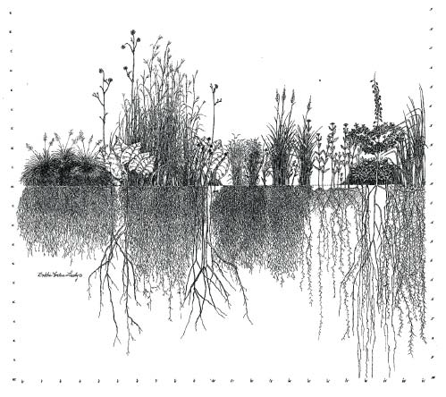 A grassland community’s soil-holding and drought-resistant attributes above and below ground illustrated by Bobby Lively.
Back to top
CHAPTER 1
THE MIDWEST MODEL
Part 4 of this book is devoted to the Midwest experience in establishing native species. Thanks to champions like Kirk Henderson and Daryl Smith of the
University of Northern Iowa, most of the how-tos are from the Iowa experience. However, when working with native plants, the scientific principles remain
the same across the country. The planting conditions and the native species that match them will change.
We no longer can reach for a “one-size-fits-all” recipe for planting success. Many previous successful mixes contained plant species that
have invasive characteristics. They served their purpose but continue to spread. Meanwhile, we continue to learn and adapt. Environmental changes and
goals have also changed greatly and continue to change. As long as environmental stewardship continues to be one of those goals, it will serve us well
to understand the art and science of establishing native species. As we learn more, we can become more site-specific in our projects.
The diagram on the previous page sums up the key reasons to establish native grasses and forbs. It displays how plants perform both below-and above ground.
The deep, fibrous root systems are what hold soil in place during heavy precipitation. It is these same root systems that hold on to moisture during drought
periods. Therefore, it is these root systems that provide erosion control under environmental fluctuations and safeguard the highway infrastructure. These
plants are not invasive. They do not require additional management or added cost. In addition, these native plants provide habitat niches for pollinators
and songbirds, increase biodiversity, improve water quality, and enhance rural or regional beauty. What’s not to like?
East of the tall grass prairie which reached Ohio, lie remnants of grasslands described as meadows, pine grassland barrens in Eastern Maine, sand plain
grasslands on Long Island, Piedmont prairies, balds and meadows of the Carolinas, Florida’s dry prairies, Alabama glades and coastal prairies into Louisiana.
These grasslands evolved with fire, just as the tall grass did. The Ozark prairie of Arkansas, Kansas, Missouri and Oklahoma did also. Other grassland
communities exist as coastal plains, barrens, karst plains, serpentine grasslands, and more.
References Cited:
Curtis, John T., 1959. The Vegetation of Wisconsin. University of Wisconsin Press, Madison.
Odum, Eugener P., 1997. Ecology, a Bridge Between Science and Society. Sinauer Associates, Inc. Sunderland, MA.
The Flora of North America Editorial Committee, 1993. The Flora of North America. Oxford University Press, Inc., New York.
The Nature Conservancy, 2009. Nature-Serve. Washington D.C.
Vickery, Peter D. and Peter W. Dunwiddie, Eds.1997. Grasslands of Northeastern North America. Massachusetts Aududon Society, Lincoln.
Back to top
CHAPTER 2
DESIGN CONSIDERATIONS
Native Plant Design Considerations
Rights-of-way present challenges for any kind of planting. Often the slopes are too steep for planting equipment, the soils are scrambled and compacted,
and the full-sun exposure and poor soils make for a harsh planting environment. At the same time, the need for erosion and stormwater control require
quick cover and a detailed specification. What do we need to consider?
-
SITE ANALYSIS - Note soil type, soil moisture, slope aspect and context.
- PROJECT NEEDS - Include: safety, erosion control, esthetics, stormwater and wetland needs.
- DESIGN SEED MIX - Match site and project needs with available, affordable native seed.
- SITE PREPARATION - Minimize soil disturbance. Leave dead stubble as mulch.
- INSTALLATION METHOD - Use a specialized drill, broadcast, hydromulch, or combination.
- DETAILED CONTRACT SPECIFICATION - State seeding rate, secure seed source quickly and use source-identified and/or local ecotypes as much as possible.
- FOLLOW-UP MANAGEMENT - First season weeds are deterred by a mowing or three. Selectively spot spray problem plants. Learn from experience with good
record-keeping.
-
ONCE ESTABLISHED - Native plantings should be burned every 5-6 years to reduce thatch build-up, weed invasions and woody encroachment. Native plant
establishment takes experienced planning, contractors and follow-up. These plantings have a sixty year history in the United States. Two of the references
that can share what others have learned are:
http://www.uni.edu/irvm and http://www.tallgrassprairiecenter.org
- Iowa experience
http://www.UWarboretum.org/research - Wisconson’s Curtis Prairie, planted in 1930’s.
REGULATORY SUPPORT
Below are the requirements for the use of native plants in an ecological approach.
23 CFR 752 - LANDSCAPE AND ROADSIDE DEVELOPMENT
752.4 LANDSCAPE DEVELOPMENT
- conformity with accepted concepts and principles of highway landscaping and environmental design.
- plant establishment of periods sufficient for expected survival from 1-3 years.
- urban sections should be landscaped as appropriate for adjacent landscape.
- rural areas should include opportunity for natural regeneration and management of native growth.
- landscaping shall include planting of native wildflower seeds or seedlings. (FHWA Policy of no waivers since 1998)
752.11 FEDERAL PARTICIPATION - b. at least one quarter of one percent of funds expended for such landscaping project is used to plant
native wildflower seeds or seedlings or both. (No waivers since 1998)
EO 13112 - INVASIVE SPECIES
https://www.invasivespeciesinfo.gov/ Establishes a federal cooperative approach and national strategy to
prevent and control the spread of invasive species, particularly invasive plants or weeds. The EO applies to all federally funded projects. The 1999 guidance
included:
- Eliminates funding for actions that increase the spread of known invasive plants/nonnatives.
- Encourages implementation of EM on Beneficial Landscaping or use of natives.
SAFETEA-LU - SECTION 6006-329
References Cited:
Harper-Lore, B.; M. Wilson, Eds. 2000. Roadside Use of Native Plants, U.S. DOT, FHWA. ISBN: 1-55963-837-0. Electronic copy is on-line at
www.fhwa.dot.gov/environment/handbook.htm
Native Wildflowers, Wildflowers and the Federal-Aid Highway Program. U.S. Department of Transportation, Washington D.C. Publication No. FHWA-EP-03-005.
The Nature of Roadsides and the Tools to Work With It. U.S. Department of Transportation, Washington DC.
https://collaboration.fhwa.dot.gov/dot/fhwa/ReNepa/default.aspx (content is no longer available) Creates a new eligibility for uses of federal aid funds by Maintenance units, etc. It specifically names as eligible: establishment of plants after control with a preference for native species.
HOW TO PROTECT NATIVE REMNANTS
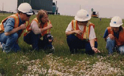
Since 1994, Caltrans protects remnant plant
communities as Biological Management Areas.
George Hartwell described this rare vernal pool
near Chico.
BENEFITS:
- Costs less to protect what exists.
- Likely to include more diversity than new plantings.
- Provides a cheap source of locally adapted seeds.
- Demonstrates your interest in conservation.
- Provides wildlife habitat.
- Preserves a benchmark for planting in the area.
- Guards dwindling natural heritage areas in State.
- Reduces need for mowing.
- Will not require replanting.
Many roadsides contain grassland remnants. These pieces of the original landscape have many values. Look for prairie remnants where an old railroad right-ofway
parallels the highway or where land might have been too rocky or too wet to farm. A thorough inventory of roadsides in your jurisdiction is the best way
to document the location of remnants and prevent their destruction in the future. It might be necessary to cease mowing for a year to determine which
species exist and the quality of the remnant.
-
Stop mowing in suspected roadside segments.
- Consult your DNR and/or TNC botanists to aid in the search.
- Existing databases can spot existing remnants adjacent to DOT ROW.
- Other public land agencies, municipal and county parklands might know of more existing remnants on rights-of-way.
- GPS these remnants and sign if possible.
- Design management plans for these protected sites, like you would for endangered species sites.
- Native grassland remnants will do best with random prescribed burns.
- Consider showcasing these treasures in a brochure for the traveling public.
- Encourage management partnerships from both sides of the ROW fence.
Highway rights-of-way precedents have been set in Minnesota and in California, among others. In the ’80s, the Minnesota DOT and DNR inventoried many grassland
and woodland remnants. “Wildflower Route” signage was installed statewide to indicate the remnants to the public, and to maintenance crews
for the use of altered management practices.
Caltrans located 19 remnants including rare vernal pools in 1995 and opted to protect these unique pieces of California’s landscape. They also marked
the locations of their “Biological Management Areas” and wrote management plans. Some of these areas are managed with prescribed burns. All
are considered good public relations.
NOTE: When protection was not possible, States like Arizona, Virginia, and Louisiana have salvaged and successfully moved plants and plant communities.
WHY ECOTYPES ARE IMPORTANT
BENEFITS:
- Match native species to local conditions.
- Establish natives more successfully.
- Guarantee seed sources.
- Save money over time.
- Get what you pay for.
- Encourage an emerging industry, alternative crop.
The Iowa Ecotype Project based at the University of Northern Iowa’s Tallgrass Prairie Center has led this effort. With the help of the Elsberry Plant
Materials Center in Missouri, native seed collections were created, foundation plots established, and native increases made available to Iowa’s commercial
seed growers. This lead to the expansion of the industry as well as availability of the native seed which was in demand by County and State highway agencies,
conservation groups, and State and Federal land managers in Iowa. Some 50 species from the three ecoregions of Iowa have been released. Licensees produce
over 60,000 lbs. of Source-Identified Iowa Ecotype Project seed/yr.
Most States have more than three ecoregions within their boundaries. The Iowa model can be a beginning point of discussion for each State. The model is
profitable to the seed growers. However, small ecoregion delineations might not be lucrative. It is important to do a Statewide market research study,
before deciding if the demand will merit this approach or a compromise. In most States it likely will. What the Iowa Ecotype project proves that through
thoughtful conversations with stakeholders, a solution can be found.
Why is the conversation important? Ecotypes do matter. On a basic level you should get what you pay for. Just because the name is the same, the ecotype
you ordered might not be adapted to your site and will fail. Dr. Jeff Norcini found in the 1990’s that two very different ecotypes of Black-Eyed Susans
naturally exist in the State of Florida. And that the southern ecotype was unlikely to establish in the north, and vice versa. This long-awaited insight
showed why some Florida plantings were failing. Source-identified seed is important.
The literature about ecotype importance is well known and lengthy. In 1986, a study showed that a warm season grass seed moved 300 miles north of its
origin, bloomed a month later than the natural populations. This study suggested that as much consideration should be given to the origin of seed as to
the species when planting grasslands.
The debate will continue, but the final proof will be in successful establishments on the ground. Whether the seed source should be limited to within
200 miles or one-half mile of the planting project also continues to warrant discussion. Successful plantings are key to erosion control, mitigation and
revegetation.
References Cited:
Houseal, Greg, 2007. Roadside Weed Management, “Issues of Ecotypes in Native Plantings”, 54-56. Federal Highway Administration. Washington
D C
http://www.uni.edu/ecotype/, 2009. Iowa Ecotype Project - Source Identified Seed. University of Northern Iowa,
Cedar Falls.
Harper-Lore, B.; M. Johnson; M. Skinner, Eds. 2007. Roadside Weed Management, U.S. DOT, FHWA. FHWA-HEP-07-017. http://www.weedcenter.org.
Back to top
CHAPTER 3
PLANNING A SEED MIX
When designing a seed mix, the goal is to create a strong plant community by combining sufficient diversity of native species, both grasses and forbs.
Select species that play different roles or occupy different ecological niches within the planting. Then combine them in such proportion that they remain
in balance. (Kirk Henderson, 2009.)
Given the objectives of highway corridors on most projects, plant native grasslands as the first cover on any disturbed soil. Later, woodland or savanna
species can be added or allowed to encroach.
KEY:
After analyzing the moisture and soil conditions of the project site, determine the ecoregion in which the project exists. Contact your Natural Heritage
Program to locate a nearby remnant preserve that is similar to your site. Visit it and ask for an inventory list of species that grow there, especially
the grasses and forbs.
ANALYSIS STEPS:
-
Visit project site and note soils and available moisture on inslope, ditch, and backslopes. Soils are likely minimal.
- Overlay project plan to mark dry, medium, and wet parts of sites. For basic cover seeding, three mixes (dry, mesic, wet) should do.
- Note plant communities of project ecoregion.
- Visit a preserve or natural area that is similar in the region. Obtain a species presence list of plants found on that site.
PROJECT OBJECTIVES:
Project objectives can further define your seed mix. A basic seeding defined by the above analysis can become temporary erosion cover, and sediment control.
The other objectives shown below will likely require enhanced mixes.
- erosion cover (basic seeding)
Examples: steep roadcut, temporary seedings, sediment care, etc.
- high visibility or enhancement
Examples: city entrance, bikeway trail, interchange, overlook, etc.
- special gardens
Examples: interpretative at welcome centers, historic sites, etc.
- conservation/wildlife habitat
Examples: pollinator and rare species protection, biofuels, etc.
- wetland mitigations
Examples: retention ponds, restorations, creations, etc.
- beautification landscaping
Examples: scenic byways, parkways, urban development, etc.
MATCHING:
- Use natural area list to pull plant names (common and scientific) for purchasing purposes or model list that match dry, mesic, or wet soils.
- With the help of a scientist or horticulturist who knows the life histories of these native species, and/or local native seed growers, learn as
much as you can about plant life histories and what to expect. These specialists know which soils species will tolerate.
- Use the following considerations to fine tune the list further.
PLANT CHARACTERISTICS:
- Divide Species list into those that tolerate dry, mestic, and wet areas.
- Chose plant heights carefully to avoid visibility conflicts later.
- Chose spring, summer, and fall interest plants if possible.
- In nature, grasses dominate, but always exist with forb species.
- Add native legumes that provide nutrients to the site.
- Add host plants for specific wildlife, like lupines for Karner Blues.
- Chose species that are commercially available in region.
- Specify natural harvest, if seed grower does not exist.
- Select species that are affordable. Grasses are more affordable than forbs.
- Enhance with forb seedlings in high visibility areas, if budget allows.
- Include a diversity of species (30 as a minimum).
This is not a perfect science and will depend on your plant knowledge to define the mixes for specification. Refer to Kirk Henderson’s explanation of
plant characteristics, and functional components to make your mixes multitask on your site. There is no one right mix for a given site.
SEEDING RATE:
Based on review of many native seed specifications, a common mistake is to seed according to agricultural practices. Seeding of native species is successful
at a far lower rate. This saves a great deal of cost, as well as seed that is otherwise wasted by seeding too heavily. There is no absolute recipe for
this rate. Experience shows that using 1-50 seeds per square foot has no better result than applying 10-15 pounds per acre. Consult with local native
seed growers and others with experience to determine the best seeding rates in your area.
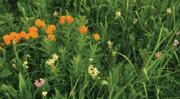
Native grasses are the key ingredient to any
native seed mix. This Minnesota grassland remnant
shows the dominance of grasses in nature.
Avoid wasting seed and money. Ultimately, success will depend on your matching of species, timing, site preparation, planting method, mulching, precipitation,
temperature, follow-up and yes, seeding rate. You have no control over some of these variables. You will increase your knowledge of what you can control
with each project. Remember every site is different and requires a different solution.
References Cited:
Henderson, Kirk, 2009. Personal communication with University of Northern Iowa.
Minnesota DOT, 2009. How to Design Site-Specific Native Seed Mixes. St. Paul. Nebraska Plan, 2009. Ecoregions, landscape and project objectives.
Lincoln.
Packard, Stephen and Cornelia F. Mutel, Eds., 1997. The Tallgrass Restoration Handbook For Prairies, Savannas, and Woodlands. Island Press, Covelo,
CA.
Back to top
CHAPTER 4
PLANT SPECIES SELECTION
NATIVE COVER CROPS CONSIDERATIONS
BENEFITS:
- Protect 3:1 or greater slopes.
- Fast growing and short-lived.
- Provide inexpensive “crop” insurance.
- Serve as nurse crops for native seedings.
- Act as erosion control until further establishment.
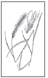
Canada wild rye
is a quick-growing,
native cover crop
that recedes as
slower-growing native
species establish.
It is native across
the U.S. except
in the southeast.
When cover crops are planted with native species, they are called nurse crops or companion crops. When cover crops are planted alone pending a more favorable
time to plant natives, they are called temporary seedings or stabilizer crops. Preferred cover crops are inexpensive, fast growing, short-lived, have
an upright growth habit, and do not form a dense canopy. Besides holding the soil, cover crops can reduce drying by sun and wind. Agricultural seedings
of annual rye, winter wheat and oats have been used for this function. Perennial non-native grasses and legumes are not recommended for use as cover crops.
They tend to out-compete native plants. More and more native plantings are accompanied with native Canada Wild Rye as a successful cover crop. Cost will
depend on supply.
Resist the temptation to plant faster-growing non-native perennial grasses or legumes along with native species. They might help stabilize the site early
on, but they will provide too much competition and persist and compromise the integrity of the planting. In particular, do not plant these perennials
with a native planting: tall fescue, perennial rye, crown vetch, red clover, bird’s-foot trefoil, sweet clover, or alfalfa.
LESSONS OF NON-NATIVE LEGUMES
When did we begin to suspect that legumes used in traditional agriculture were not appropriate for roadside plantings?
1. When we learned that birdsfoot-trefoil is glyphosate resistant.
2. When we learned crownvetch was being planted to prevent forest encroachment.
3. When we learned how many agricultural legumes have become invasive.
4. When the legume kudzu was found near Portland, Oregon.
5. When black locust began to displace oak forests along the Mississippi River.
We began using nonnative legumes as problem solvers to provide quick cover for erosion control, and to build soils for future plantings. They are too
good to be true! Evidence shows that crownvetch and birds foot-trefoil have outcompeted many new seedings. Agency-planted sweet clovers continue to spread
across the landscape after wildfires. Kudzu continues to adapt and spread to northern and western States. Consider alternatives appropriate to your region:
- Roundheaded bushclover, Lespedexa cuneata instead of Sericea lezpedeza.
- Wisteria frutescens instead of Wisteria floribunda/sinensis.
- Partridge pea, Chamaecrista fasiculata for Bird’s foot-trefoil.
- Kentucky coffeetree, Gymmoclaudus dioica instead of black locust.
- Wild indigo, Baptisia bracteata instead of crownvetch.
- Purple prairie clover, Dalea purpurea instead of nonnative clovers (Trifolium sp.).
References Cited:
Burrell, C. Colston, 2006. Native Alternatives to Invasive Plants. Brooklyn Botanic Garden, Inc. New York.
Henderson, Kirk, 2009. Personal communication. University of Northern Iowa.
Marinelli, Janet, and John Randall 1996. Invasive Plants, Weeds of the Global Garden. Brooklyn Botanic Garden, Inc. New York.
Consult also with your State Invasive Species Council and/or Native Plant Society.
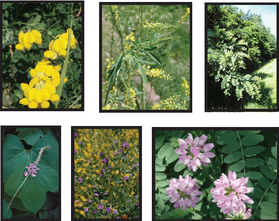
These fast-growing legumes have become management problems: birdsfoot trefoil, sweet clover, black locust, kudzu, alfalfa, and crownvetch.
PRACTICAL PLANT CHARACTERISTICS
QUICK-ESTABLISHING - Some species are quick to establish and are often early successional plants that will recede as others take their place. They provide
fast erosion control and people-pleasing results: Canada wild rye (Elymus Canadensis), Black-eyed Susan (Rudbeckia hirta), Rough dropseed
(Sporobolus compositus), and Partridge pea (Chamaechrista fasciculata).
WARM-SEASON GRASSES - Like corn, these grasses continue to grow throughout the summer. They provide long-term erosion control and rich fall color: Big
bluestem (Andropogon gerardii), Indian grass (Sorghastrum nutans), Switchgrass (Panicum virgatum), and Side-oats grama (Bouteloua
urtipendula).
COOL-SEASON SPECIES - Plantings are further strengthened by plants that start growing earlier in the spring. These species provide important erosion control
for late winter and early spring plantings and should occupy the niche sought by nonnative cool season grasses such as Smooth brome, Fescue and Kentucky
bluegrass. Examples: Canada wild rye and Virginia wild rye (Elymus virginicus), Western wheatgrass (Agropyron smithii) and most sedges
(Carex spp.).
LEGUMES - These nitrogen-fixing plants establish readily and provide food and valuable wildlife cover: Leadplant (Amorpha canescens), White wild
indigo (Baptisia alba), Round-headed bush clover (Lespedeza capitata), Partridge pea (Chamaecrista fasciculata), Showy tick-trefoil
(Desmodium canadense), Illinois bundleflower (Desmanthus illinoiensis), and Purple prairie clover (Dalea purpurea).
COLOR PLEASERS - People like dramatic color. Many native species are capable of creating masses of color visible at 65 mph. These establish readily and
are some of the least expensive: Gray-headed coneflower (Ratibida pinnata), Ox-eye sunflower (Heliopsis helianthoides), Wild bergamot
(Monarda fistulosa) and New England aster (Symphyotrichum novae-angliae). Other asters and goldenrods will also produce the desired
effect.
SPRING BLOOMS - The prairie is showier in summer and fall than in spring. These species perform in mid-spring: Ohio spiderwort (Tradescantia ohiensis),
Golden Alexanders (Zizia aurea), Large flowered beardtongue (Penstemon grandiflora), and Creamy indigo (Baptisia bracteata).
LITTLE GUYS - Like kids chosen last on a playground team, these are often overlooked, but they are good for team chemistry and habitat composition: Mountain
mint (Pycnanthemum virginianum), Bastard toadflax (Comandra umbellata), Alumroot (Heuchera richardsoniss), Wild quinine (Parthenium
integrifolium), Prairie sage (Artemisia ludoviciana), and of course, sedges.
NORMS - This catch-all category includes popular species that did not show up in the other categories. They are prairie “Regulars” that remind
us we are looking at prairie: Butterfly milkweed (Asclepias tuberosa), Prairire blazing star (Liatris pycnostachya) and Little bluestem
(Schizachyrium scoparium).
GUILDED LILIES - Beware of investing heavily in forb species that cost too much and/or might not succeed under roadside conditions. Try small amounts
of forbs with tiny seeds that are considered
late successional: Shooting star (Dodecatheon meadia), Prairie violet (Viola pedatifida), Turk’s-cap lily (Lilium michiganeense),
and Bottle gentian (Gentiana andrewsii).
References cited:
Henderson, Kirk, 2009, Personal Communication. University of Northern Iowa.
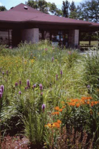
A native demo garden as the entry to a Wisconsin DOT
Welcome Center on I 94.
Back to top
CHAPTER 5
NATIVE SEED SPECIFICATION
OBJECTIVES:
- Avoid substitutions but have a back-up plan.
- Announce this is not a traditional seed mix.
- Secure native seed in areas of short supply.
- Guarantee regional seed source.
- Obtain native harvest when no seed source exists.
GENERAL REQUIREMENTS YOU CAN USE:
- Native grass or forbs should be supplied as Pure live seed (PLS) per State.
- Seed shall conform to the latest seed law of the State.
- Substitutions only granted by the Agricultural Engineer (or similar).
- All native grass seeds should be cleaned and de-bearded.
- Approved vendors or seed source lists on file with the DOT only.
- All Native seed shall be of a known origin, and yellow-tag or source identified.
- Wild-type seed is derived directly from native, wild stock, including seed collected in the wild and placed into production and/or direct harvest
of native stands plus avoidance of unintentional selection.
- Varieties or cultivars of native grasses and forbs are usually not allowed.
SAMPLE SPECIAL PROVISIONS THAT CAN BE ADDED:
- Contractor must present confirmed native seed order within 60 days of winning award. This avoids contractors assuming the seed is easy to find and commonly
available.
- If project ends in a season not appropriate for native seeding, use a temporary seeding.
- Method of seeding equipment should be clearly stated.
- Treatment for noxious weed control before seeding should be included.
- Seeding contract should be issued/awarded separately whenever possible to save costs over time.
- The alternative is to write detailed specs that make very clear what a contractor must do and achieve to be paid.
- Call for a restoration/mitigation specialist to advise contractor and supervise seeding.
More information on developing native seed mixes and standards can be found in the Minnesota Department of Transportation’s Native Seed Design for Roadsides,
available online at: http://www.dot.state.mn.us/environment/erosion/native-seed-mix-dm.pdf
References Cited:
Graeve, Kenneth, 2009. Personal communication.
Harper-Lore, B.; M. Wilson, Eds. 2000. Roadside Use of Native Plants, U.S. DOT, FHWA. ISBN: 1-55963-837-0. Hard copies available from Island Press, Electronic
copy is on-line at: http://www.fhwa.dot.gov/environment/handbook.htm
Minnesota DOT, 1995. Standard Specifications for Construction. St. Paul, MN.
HOW TO READ A NATIVE SEED LABEL
FEDERAL AND STATE STANDARDS:
Although native seed is sometimes handled differently than agricultural seed, as it should be, all seed sold in the United States follows seed standards,
including purity. The Federal Seed Act mandated that interstate commerce in seed be based on “truth in labeling”. Each State Department of
Agriculture samples and tests seed sold. Labeling must abide by both Federal and State seed laws. Check with your Department of Agriculture for details.
For example, in Minnesota, native grass seeds are considered agricultural seed. Forbs are also considered agricultural unless packaged for homeowners.
Per law, the label must declare:
- Kind and Variety of Seed - e.g Switchgrass, Laura
- Lot Number - identification from vendor records
- % Pure Seed - seed of desired species that could germinate
- % Weed Seed present - as little as possible
- % Other Crop - if applicable
- % Inert matter - chaff, twigs, substances that will not grow
- % Germination - must be tested within 15 months of sale
- Noxious Weed Seeds - names must be listed
- Number of Weed Seeds per Pound - a clue about composition
- Origin - State, Region, County
- Germination Test Date - month and year
- Labeler’s name and mailing address
SOURCE-IDENTIFIED SEED:
Although Iowa is described in this section, many states use Yellow Tag. Yellow Tag seed is native seed that has been certified to source by the State
Crop Improvement Association in accordance with standards set by the Association of Official Seed Certifying Agencies (AOSCA). Source-identified seed
is not unique to Iowa. Other States use AOSCA standards. In Iowa’s Ecotype Project the “Yellow Tag” provides a ’fasttrack’ release procedure
when:
- existing commercial supplies for a species are inadequate.
- propagation material of specific ecotypes is needed for ecosystem restoration.
- potential for immediate use is high.
- potential for commercial production beyond plant community sites is low.
RECOMMENDATIONS TO CONSIDER:
- Use Yellow Tag over non-source identified seed in some States.
- Use germ plasm that originate as close to the project site as possible.
- All seed should be purchased as pure live seed, unless should a natural harvest is needed.
- A minimum buffer of one-quarter mile is recommended for use of non-local seed sources, cultivars or varieties to protect native remnants and other seed
production areas. For other purposes, source distance varies.
References Cited:
NRCS standards - http://www.nrcs.usda.gov/technical/eFOTG/- content is no longer available.
Minnesota Board of Water & Soil Resources, 2009. BWSR Seed Source/Seeding Guidelines. St. Paul, MN.
Packard, Stephen and Cornelia F. Mutel, Eds. 1997. The Tallgrass Restoration Handbook. Island Press.
HOW TO SEED NATIVE VEGETATION
TIMING:
Seeding contracts cannot always be fulfilled at optimum times. It helps if construction and seeding contracts are awarded separately to avoid pressure
from construction. Here is what works in the Midwest. Adjust for your region.
Mid-spring provides best soil temperature and moisture conditions for germination and survival of warm season species.
Summer is the least optimum time because of water stress. a. It is preferable to plant a temporary seeding and do a permanent mix later.
b. When forced to plant, increase rate by 25%, drill seed, and mulch site.
Late fall dormant seedings provide natural scarification and improved forb take.
Frost seeding takes place in February and March on seedbeds prepared in fall.
SITE PREPARATION:
Site preparation must exterminate existing weeds yet minimize soil disturbances that would increase weeds. Igniting this way, jeopardizes the project.
Bare soils should be firm but not compacted for drill seedings. Bare soils should be rough and a little soft (after rain) for hydro-seeding.
Ditch cleanouts should be roughed up before seeding.
Existing turf should be dead and dried, leaving mulch and roots in place. Drill seeding into this base minimizes soil disturbance and
invasions.
PLANTING METHODS:
Drilling: Chose a drill that can accommodate native grass and forbs. This method is preferred on level rights-of-way. For uniform coverage,
drill at a light rate and go over the area at least twice.
Broadcasting: This method prevents smaller seeds from being buried too deeply. Fertilizer spreaders with agitators have worked well to
distribute forb and grass seeds. Very fine seed might be cast by hand.
Hydroseeding: It is safer to hydroseed steep slopes. The hydro-mulch reduces erosion and colored mulch makes a positive impression on
the public. However, this method can double the cost of seeding. Seeding rates must be increased to allow for seed damage and loss to mulch shading, etc.
A high paper/ low-wood mulch works well. It is a bare ground operation and the seeding rate is hard to control with this method. Best in arid regions.
FOLLOW-UP:
Herbicide used to kill broadleaf weeds will kill native forbs, so target carefully. Mowing at 6" at least three times the first growing season is
advised. Prescribed fire to reduce thatch and weed invasion every 5-6 years works well.
References Cited:
Henderson, Kirk, 2009. Personal communication. University of Northern Iowa.
Harper-Lore, B.; M. Wilson, Eds. 2000. Roadside Use of Native Plants, U.S. DOT, FHWA. ISBN: 1-55963-837-0. Hard copies available from Island Press, Electronic
copy is on-line at http://www.fhwa.dot.gov/environment/handbook.htm
Back to top
CHAPTER 6
EROSION CONTROL USE
WHY PLAN FOR EROSION CONTROL
BENEFITS:
- Minimize erosion/sedimentation.
- Stabilize slopes.
- Safeguard infrastructure.
- Protect state waters.
- Reduce project costs.
- Comply with NPDES.
Protecting the waters of the State is required of all projects. This section will not attempt to give you everything you need to know about erosion control,
but rather will underscore some important lessons learned. Proper erosion control efforts that save time and maintenance are more cost effective permit.
than sediment control later. Predesign days of analysis and planning are critical to success. Understanding the permit requirement of the National Pollutant
Discharge Elimination System (NPDES) is required for construction activities. That permit is posted at the construction headquarters. Although the contractor
is responsible for compliance, liability lies with the State who hired the contractor. Consequently, continual interaction and good record-keeping protects
the environment and everyone involved. Some States require contractors to be co-permittees and share liability. Inspections increase with land-disturbing
activities. The NPDES permit is just one of the permits (State, Wetland, and Watershed) needed to allow construction activities. Field flexibility is
essential to following the erosion control plan, and managing the contractor. The timing of mulching and seeding, silt fence installation, temporary sediment
basins and sediment removal seeding, sodding, composting, blanketing, berming, and engineered solutions along with maintenance, add to the complexities.
When the project begins, prevent vegetation removal and other disturbances as much as possible. Ongoing maintenance follow-up will repair and protect
the project. This maintenance underscores the need for Maintenance Division’s involvement during predesign.
NOTE: A Storm Water Pollution Prevention Plan (SWPPP) is necessary to deal with sediments from runoff. SWPPP and Erosion Control Plans should
be in concert.
CHECKLIST:
- Predesign site analysis.
- Erosion control plan.
- Train and inform contractors.
- Secure & post NPDES permit.
- Mulch/Seed within 7 days of disturbance.
- Repair after storm events within 48 hours.
- Record date of any changes to plan.
References Cited:
Cazenas, Patricia. 2009. Personal communication.
Environmental Protection Agency - http://www.EPA.gov/ (compliance monitoring, BMPs, Stormwater
Pollution Prevention Plan guide, templates, resources, permits, etc.)
Mn/DOT and Bonestroo, 2007. Erosion Control Handbook. Minnesota Department of Transportation, St. Paul.
International Erosion Control Association http://www.IECA.org (training and technology, standards, resources, and certification)
National Stormwater Center - http://www.NPDES.com
NATIVE GRASSES MINIMIZE EROSION
Plant cover is the main controllable factor in preventing or controlling soil erosion.
“Erosion is one of the interactions between climate, vegetation, and soil, in which the plant cover is a decisive factor.” native grasses
and forbs break the force of rain The foliage, fallen leaves and stems. Their humus in the topsoil creates a sponge-like consistency. It is only when
the vegetation is closely cut or grazed and the amount of roots and rhizomes reduced that serious erosion is possible. It was during the great drought
of 1933-1940 that studies first showed the grasslands’ endurance and recovery first. “The undisturbed prairie is a closed community, and invaders
- with rare exceptions - are excluded.” Aggressive native shrubs show an inability to advance into true prairie.
Following the great drought, it took over 20 years for “the same kind of prairie vegetation that existed before the seven years of devastating drought
had slowly been replaced.” But it returned! John E. Weaver’s fifty-year study of the Midwest included the States of Nebraska, Kansas, Colorado,
South Dakota and Texas with added information about grasslands from Washington to Ohio.
References Cited:
Weaver, J. E. 1954. North American Prairie, Johnsen Publishing Company, Lincoln, NE.
Weaver, J. E. 1968. Prairie Plants and their Environment, University of Nebraska Press, Lincoln.
BLUESTEM - CROWNVETCH, SOIL-ROOT COMPARISON
Little bluestem, a perennial grass. Is a dominant upland grass from Nebraska to Minnesota and beyond (all States except Oregon, Nevada, and Alaska). Although
often described as a bunch grass, it can provide a sod-mat on steep slopes. Its seedlings are vigorous; tiller early and abundantly; and develop deep,
well-branched root systems. Little bluestem can be grown in native grass/forb association, stakable mats.
Soil-root comparisons have been accomplished for decades, using the monolith method developed by John Weaver, known for his lifelong study of grassland
dynamics. Scientists first excavate the entire plant, then wash the soil away to sample root systems. In our illustration, the little bluestem drawing
is of an actual 52” little bluestem from one of his monoliths published in a 1949 Ecological Monograph.
The crownvetch plant was randomly excavated from an interstate corridor planting at maturity in 2009. It was carefully washed, mounted, and traced to
assure accuracy in its illustration. Its actual top and root length is 8”. The drawings are scaled to represent a true comparison.
The two plants are compared here to suggest the fibrous-rooted native grass is more likely to hold soil in place than crownvetch. However, crownvetch
is often favored as an erosion control on 2:1 highway slopes because it is easier and quicker to establish. Although the establishment of a native grass
like little bluestem can take time, technological advances through research now give highway decision-makers the opportunity to contract-grow native grass-sods
that can match the edaphic conditions of a site and be staked into a slope like a blue grass sod following construction for immediate erosion control.
Decision-makers no longer need to rely on easy and quick seed mixes that often include invasive plants like crownvetch, which have long-term economic
and ecological costs.
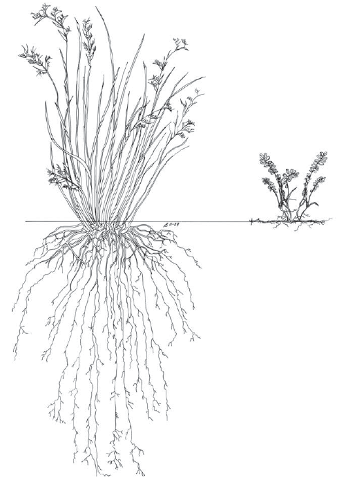
Soil root comparison of two erosion control plants: little bluestem (Schizachyrium scoparium) 52" (left)
and crowntvetch (Coronilla varia) 8" (right). Image by Bonnie HarperLore.
References Cited:
Meikle, Tim W. 2007. EcoSod: A native sod solution for revegetation. Roadside Weed Management, p. 50. Federal Highway Administration, Washington,
DC.
Weaver, J.E. and Fitzpatrick, T.J. 1935. The Prairie. Ecological Monograph, Vol. 4, No. 2. University of Nebraska, Lincoln.
Weaver, J.E. and Darland, R.W. 1949. Soil-root relationships of certain native grasses in various soil types. Ecological Monograph. 19:303-338.
Harper-Lore, B.; M. Johnson; M. Skinner, Eds. 2007. Roadside Weed Management, U.S. DOT, FHWA. FHWA-HEP-07-017.
http://www.weedcenter.org/store/docs/books-brochures/roadside%20weed%20management.pdf
AFFORDABLE NATIVE SOD FOR EROSION CONTROL
- Minimize soil loss.
- Stabilize slopes.
- Reflect surroundings.
- Increase diversity.
- Save cost over time.
Call the work revegetation, restoration, or reclamation, transportation projects can often simply plant native species to accomplish their erosion control
objectives. Native species suffer a bad rap in erosion control projects. Native species are not all slow to establish. Native species are not too costly
to use. And we have learned from research over the last couple decades that native plant species can do the job. Examples follow:
On the Salmon Pass Project in Idaho, all native species that grew on the site before construction began were inventoried by the Forest Service. Seed of
native grasses, forbs, shrubs and trees were collected and put into greenhouse production. As soon as construction was complete, the 2:1 slope of more
than 300’ elevation was hydroseeded with a native grass and forb seed mix. The hand grown seedlings were then planted into the hillside. A year later,
this seemingly impossible slope planting was successful without any erosion problems.
A recent Small Business Innovative Research Grant funded the development of an affordable native sod ready to do erosion duty from the day it is staked
into the slope. Ecosod is now patented. The value of this native sod with erosion mesh embedded in the sod as it is grown, is immeasurable. It can replace
traditional sods that are harder to maintain on steep slopes. Ecosod is grown to specification to match the project site conditions. Because it is greenhouse
grown, Ecosod can be propagated and delivered to meet a changing construction schedule during any season. Ecosod has succeeded at a cost no greater than
bluegrass sods.
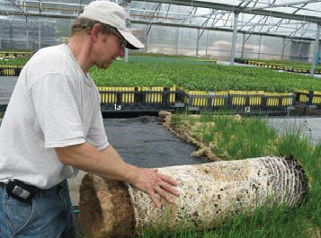
Native “Ecosod” is as affordable as traditional sods for erosion control.
A native seeding can also meet NPDES requirements of quick establishment, if a native mix is carefully designed. By using cool season grasses in the mix,
quick establishment is possible. Species that can accomplish the necessary control include: Canada wild rye (Elymus Canadensis), Virginia wild
rye (E. virginicus), Western wheatgrass (Agropyron smithii) and most sedges (Carex Sp.) Many common forb or wildflower species
can add diversity and aesthetics: Black-eyed Susan (Rudbeckia hirta), Gray-headed coneflower (Ratibida pinnata), Wild bergamot (Monarda
fistulosa) and more depending on your ecoregion. These species are seeded at a far lower rate than nonnative seed mixes and therefore do not
cost more per acre. Factors for successful seedings include: appropriate seed depth, level of compaction, seed-tosoil contact, moisture availability,
soil texture, use of mulch, weed control, planting dates. Some of these factors are easier to control than others.
References Cited:
http://www.epa.gov/npdes/stormwater - vegetation covers discussed.
http://www.nrcs.usda.gov - Information on seeding, conservation, and commercial seed.
http://www.nps.gov/ - The Plant Conservation Alliance is source of information.
Back to top
PART 5
INTEGRATED ROADSIDE VEGETATION MANAGEMENT
Introduction
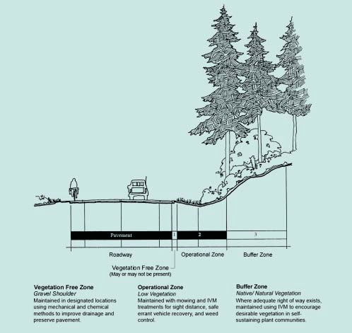
Washington DOT’s zone approach to vegetation management begins with this illustration.
Integrated Roadside Vegetation Management or IRVM is the currently accepted approach used by State Departments of Transportation in many States. There
really is nothing new about it. IRVM underscores the importance of using “all the tools in the toolbox”, a phrase so common among land managers,
it seems cliche. Yet this section of the tool descriptions will likely prove valuable to many who continue the agricultural approach of mowing and spraying
solutions only. Integrating the many methods we have learned over past decades builds on information about the vegetation in ecoregions. IRVM is a logical
part of an ecological approach to roadsides. Better understanding of the regional vegetation will allow us to chose which tool or combination of tools
we need to get the result we want. IRVM underscores how vegetation is tied to everything else.
The State of Iowa has been credited with coining the term, “integrated roadside vegetation management”. In fact IRVM is part of statute Section
314:22 of Iowa code. “It is declared to be in the general welfare of Iowa and a highway purpose for the vegetation of Iowa’s roadsides to be preserved,
planted, and maintained to be safe, visually interesting, ecologically integrated, and useful for many purposes.” The Iowa code could be applied
in any State for highway purpose.
Kirk Henderson of Iowa’s Native Roadside Vegetation Center will be the first to tell you that in his State, the use of native plant species has become
the tool of choice. “Located in the heart of an agricultural region, Iowa boasts the most altered landscape of any State. Out of desperation we
turn to roadsides to reintroduce a little wildness.” Many in Iowa claim that well-established stands of native grasses and forbs prevent the spread
of invasive plants. That claim is reason enough to consider adding this tool to your toolbox. It is intuitive that these deep and fibrous-rooted plants
fill soil niches to the extent that invasive seeds cannot find a home.
In 1997, the National Roadside Vegetation Management Association (NRVMA) published How to Develop and Implement An Integrated Roadside Vegetation Management
Program. They defined Integrated Roadside Vegetation Management as: “a decision-making and quality management process for maintaining roadside
vegetation that integrates the following:
- the needs of local communities and highway users
- the knowledge of plant ecology and natural processes
- design, construction, and maintenance considerations
- monitoring and evaluation procedures
- government statutes and regulations
- technology
...with cultural, biological, mechanical, and chemical pest control methods to economically manage roadsides for safety plus environment and visual quality.”
Paging through the many vegetation management conferences in the ’40s and ’50s, we learned quickly that the problems of roadsides have not changed much
over time. Nor have the solutions. Vegetation mangers spent so many years searching for the best tool or solution that they missed the advantages of using
a combination. “Using all the tools in the toolbox” is what IRVM is about. A combination of tools selected, based on ecological understanding,
can be cost-effective and ecologically sound.
References Cited:
NRVMA, 1997. How to Develop and Implement an Integrated Roadside Vegetation Management Program. NRVMA, Newark, DE.
Kirk Henderson. 2007. Roadside Weed Management. “Integrate all the tools” Federal Highway Administration, Washington D.C.
Willard, Ray, 2009. Personal Communication with the Washington Department of Transportation.
Harper-Lore, B.; M. Johnson; M. Skinner, Eds. 2007. Roadside Weed Management, U.S. DOT, FHWA. FHWA-HEP-07-017. http://www.weedcenter.org
WHY AND WHERE TO APPLY ECOLOGICAL PRINCIPLES
APPLICATION TO ROADSIDES:
Land managers share the same objectives and within the highway corridor, there are added constraints of traveler safety and mobility. In order to clarify
goals and objectives, the Washington DOT has illustrated where in the highway corridor cross section a tool or combination of tools should be applied
based on the purpose of the right-of-way.
It is logical to match the management tools to roadside functions. This helps area maintenance crews use their plans and choose appropriate tools, techniques,
and timing. Together, the plan and illustration help prioritize activities and budgets. Based on geographic inventories of maintenance activities, weed
infestations, sensitive areas, and related information, WashDOT’s record-keeping and database allow them to evaluate and reference site specific treatments.
These plans become the basis for ongoing crew training and adaptation. Their open process encourages input from the general public, its neighbors, and/or
any other statewide or local interests. All areas of the State have a plan. The Washington DOT model is a practical starting point for other states.
References Cited:
Highway Research Board, 1932 - Forward. Report on Committee on Roadside Development. Washington D.C.
Ohio State University, 1941-1960. Ohio Short Course on Highway Development. Columbus, OH.
Washington DOT, 2009. https://wsdot.wa.gov/construction-planning/protecting-environment/maintaining-vegetation-along-our-highways/integrated-roadside-vegetation-management-plans
Back to top
CHAPTER 1:
PLANNING AHEAD - HOW TO DEVELOP AN IRVM PLAN
BENEFITS:
- Improved safety.
- Increased savings.
- Improved Environmental Stewardship.
- More flexibility for crews.
- Enhanced Aesthetics.
- Improved public relations.
In 1996, many vegetation managers were talking about the need for an integrated roadside vegetation management approach. We were not certain what that
would look like. National Roadside Vegetation Management Association (NRVMA) members knew it was more than traditional mowing and spraying operations.
Under the leadership of Richard Arnebeck, a task force dug in. The resulting 40 page booklet, “How to Develop and Implement an Integrated Roadside
Vegetation Management Program,” served to stimulate vegetation management plans across the country. At the time the Federal Highway Administration
suggested that all DOTs draw up a statewide management plan to address the spread of invasive species.
The IRVM approach suggests “using all the tools in the toolbox” including: mechanical, biological, cultural, chemical, handsoff, and conservation
methods. Implementing IRVM means getting input from all the stakeholders and incorporating regulatory guidelines. IRVM varies from State to State based
on State policies, natural ecosystems, and public needs. This task force’s efforts began the planning conversation.
The goal to “put a plan on paper” aims at problems that plague highway agencies: limited budgets, personnel turnover decentralization, privatization,
and public pressure. Suggestions for how to prioritize limited resources are included. With improved technologies like GPS, vegetation inventories are
now feasible and can be used to improve planning and demonstrate success with this approach. For more details, please read the NRVMA document and related
references.
CHECKLIST:
- Promote IRVM
- Organize a steering committee
- Write a mission statement
- Establish goals and objectives
- Prioritize activities based on GIS inventories
- Budget accordingly
- Evaluate level of success
- Support with annual plan, training, and record keeping
- Continue to adapt
References Cited:
Federal Highway Administration, 2005. The Nature of Roadsides and the Tools to Work with it. FHWA, USDOT, Washington D.C.
Iowa’s integrated roadside vegetation management program is outlined at http://www.uni.edu/irvm/
Minnesota Department of Transportation, 2008. Best Practices Handbook for Roadside Vegetation Management. Minnesota State University, Mankato.
National Roadside Vegetation Management Association Task Force, 1997. How to Develop and Implement an Integrated Roadside Vegetation Management Program.
NRVMA, Newark, DE.
NRVMA, Delaware.
NCHRP 341, 2005. Integrated Roadside Vegetation Management: A Synthesis of Highway Practice is available online:
http://onlinepubs.trb.org/onlinepubls/nchrp/
NCHRP 14-16, 2009. National Vegetation Management Guidelines. In progress and will be available on line.
Washington State Department of Transportation IRVM plans are available at
BEST MANAGEMENT PRACTICIES
The benefits are cost efficiency, environmental stewardship, Executive Order 13112 compliance and public relations improvement. As conditions on the ground
change, vegetation managers adapt. Here are some of the best common sense practices we have collected from DOTs so far:
“An affordable weed washer (innovative portable
invasive species rinse off and reclaim system)
designed for highway construction and
maintenance” equipment now exists.
- Develop an integrated roadside vegetation management (IRVM) plan.
- Update annual training with GPS technology to aid inventories.
- Establish sustainable, native vegetation.
- Eradicate invasive plants before construction.
- Certify sand and gravel pits.
- Specify weed-free mulches.
- Berm existing topsoils. Avoid importing soil.
- Reduce mowing to one swath along paved edge.
- Power wash all equipment before and after operations.
- Engage in regional partnerships.
References Cited:
Johnson, Ann M. 2008. Best Practices handbook for Roadside Vegetation Management. Minnesota State University, Mankato.
National Roadside Vegetation Management Association Task Force, 1996. How to Develop and Implement an Integrated Roadside Vegetation Management Program.
NRVMA, Newark, Delaware.
Transportation Research Board Committee, AHD50 - Roadside Maintenance and Operations.
Back to top
CHAPTER 2
ROADSIDE SUCCESSION
SUCCESSION - on unmowed roadsides. What happens over time when you stop caring for the land, as demonstrated by a 50 year study of an
abandoned field in New Jersey, gives us clues to roadside vegetation management:
YEAR 1: annual herbs like wild mustard, lambs quarters, sweet clover, Curly dock, Canada thistle, ragweed, prickley lettuce, and daisy
fleabane.
YEAR 3: perennial herbs, goldenrod, asters, quack grass, smooth brome, little bluestem, mullein, oxeye daisy, black-eyed Susan, Queen
Anne’s lace, chicory and yarrow (up to 10 years without woodies).
YEAR 6: red cedar, wild rose, sumac, pin cherry, Queen Anne’s lace, goldenrod.
Year 12: red cedar with little bluestem, Indian grass, grey-headed coneflower, purple prairie clover, coreopis, monarda, have replaced
pioneer plants. Shrubs can include wild rose, hazelnut, black berry, poison ivy.
YEAR 30: red cedar, bayberry, black berry, sumac....red maple, quaking aspen, black cherry and pin oak with grassland species in openings
only.
YEAR 50: Red maple, black cherry, sassafras, and pin oak abundant and shaded out most of lower growing cedars and shrubs.
During any of these stages, invasive species in the soil bank and/or adjacent lands can invade the open soils on the site. Depending on which region,
invasives that will invade during the pioneering of early successional stages can include: multiflora rose, knapweeds, kochia, perennial sowthistle, common
teasel, purple loosestrife, tree of heaven, yellow starthistile, common tansy, sericea lespedeza, cogongrass, medusahead rye, Johnson grass, Japanese
knotweed, black locust, salt cedar, Russian olive, privets, Japanese honeysuckle, Chinese silver grass or kudzu for examples.
Until recently, many scientists believed that given enough time all ecosystems in a region would reach a single climax type controlled by the regional
climate. Now ecologists talk about the dynamic nature of plant communities changing over time in reaction to natural and human-made disturbances. “An
ecosystem is seen as a mosaic of variegated pieces that change character and function over time.” Both views are based on change over time, which
has been scientifically predictable based on years of study. However, with the potential changes in precipitation and temperatures with climate change,
balanced or fluctuating interpretations will not likely apply. Remember the term “adaptive management” and apply it based on the change you
see around you. While geologic and soil conditions might remain the same, interrelationships with animals, plants and humans will change diversity as
we now know it.
References Cited:
Collins, Beryl Robichaud and Karl H. Anderson. 1994. Plant Communities of New Jersey, A Study in Landscape Diversity. Rutgers University Press.
New Brunswick, NJ.
Curtis, John T. 1959. Vegetation of Wisconsin. University of Wisconsin Press, Madison.
Daubenmire, Rexford. 1969. Plant Communities: A Textbook of Plant Synecology. Harper & Row, Publishers, Incorporated, New York.
Odum, Eugene P. 1989. Ecology and Our Endangered Life-Support Systems. Sinauer Associates, Stamford, CT.
CHAPTER 3
HOW TO INVENTORY VEGETATION
BENEFITS:
- Utilize a standard method used by other agencies.
- Share information within partnerships to accomplish more.
- Provide a benchmark to measure weed control success.
- Prepare maintenance budgets more accurately.
The North American Weed Management Association (NAWMA) system for mapping non-native plant species provides a standard that will coordinate efforts to
control and prevent plant invasions. The system creates a standardized format for the collection and mapping of non-native plant species that allows for
information to be shared and transferred across boundaries. Sharing information will promote coordinated control efforts and systems for early warning
and detection. The exchange of distribution and abundance information on invasive species is an essential component of containing them. The NAWMA standards
have been adopted by the US Forest Service, the National Park Service, the Fish and Wildlife Service, and many other public and private organizations.
These standards represent a minimum of what should be collected, and should include methods that incorporate quality assurance and risk assessments.
THE NAWMA SYSTEM COLLECTS THE FOLLOWING VARIABLES:
|
Date
|
Examiner
|
Plant Name/common name
|
|
Plant code
|
Infested area
|
Gross area
|
|
Canopy
|
Ownership
|
Source of data cover
|
|
Country
|
State
|
County or Municipality
|
|
Location (Legal, Lattitude AND Longitude, UTMs)
|
References Cited:
Harper-Lore, B.; M. Johnson; M. Skinner, Eds. 2007. Roadside Weed Management, U.S. DOT, FHWA. FHWA-HEP-07-017. http://www.weedcenter.org
North American Weed Management Association (NAWMA) http://www.NAWMA.org
Rew, Lisa J. and Monica L. Pokorny, 2006. Inventory and Survey Methods for Nonindigenous Plant Species. Montana State University Extension, Bozeman.
Stohlgren, Thomas J., David T. Barnett, and Sara E. Simonson, 2005. “Beyond North American Weed Management Association Standards”. Fort Collins
Science Center, CO.
HOW TO USE GPS RECEIVERS
BENEFITS:
- Pinpointing weeds on a GIS map.
- Monitoring weeds after treatment.
- Informing prevention, Management, and policy decisions.
- Locating endangered plants and remnants.
- Uploading data to compatible partners.
- Maintaining field records.
The Global Positioning System (GPS) is a satellite-based navigation system consisting of 24 satellites put in orbit by the U.S. Department of Defense.
Some GPS receivers can lock on to 12 satellites at a time for increased accuracy. Civilian use began in the 1980’s. GPS is free to the public and works
in any weather, anywhere, 24-7. GPS receivers with Wide Area Augmentation System (WAAS) can achieve accuracy within less than three meters. WAAS is also
free. Differential GPS (DGPS) uses a network of towers and transmits corrected signals by beacon transmitters.
CHECKLIST:
- Power on unit
- Unit will display accuracy based on satellite locks
- Unit will display position on map
- Save position as a “waypoint”
- Most units display movement and speed, etc.
- The tracking map shows highways and major features
- After inputting information, power off
- Recharge rechargeable units or replace batteries in others
This GPS inventory manual has been field tested by
the Mississippi DOT.
VEGETATION INVENTORY USE:
By using GPS locations of weed occurrences, land managers can better plan the use of resources for weed management. A number of protocols and software
exist for this work.
One is The Nature Conservancy’s “Weed Information Management System” (WIMS). WIMS information includes: plant species, management plan, treatments
and tracking. Most systems use the North American Weed Management Association (NAWMA) Standards to shape files for mapping in any standard GIS program.
Use of these standards results in data that is compatible with partner agencies’ use. Their protocol is especially useful in Cooperative Weed Management
Areas (CWMAs). Mississippi State University and MSDOT have published a helpful protocol for the use of GPS to inventory transportation corridors. It is
available online at http://www.gri.msstate.edu/publications/docs/2009/09/6619DOT_Veg_Inventory_
Project_Training_Manual.pdf.
References Cited:
Maddox, Victor, Et. Al, 2009. State Department of Transportation Inventory Protocol Project - Training Manual. Mississippi DOT, Jackson.
North American Weed Management Association, Standards, http://www.NAWMA.org
Rew, Lisa J. and Monica L. Okorny, 2006. Inventory and Survey Methods for Nonindigenous Plant Species. Montana State University Extension, Bozeman.
The Nature Conservancy, http://www.tncweeds.ucdavis.edu/wims
Back to top
CHAPTER 4
NOXIOUS WEED OR INVASIVE PLANT?
What are Invasive Plants?
Invasive plants are alien species whose introduction is likely to cause economic or environmental harm or to harm human health. Kudzu is an example of
an invasive plant from Asia deliberately introduced to solve land use problems in the 1920’s. Plants native to the United States can also become aggressive
when moved to another region in the country. Black locust, Robinia pseudoacacia, is such an example. Invasives are often called weeds.
What are Noxious Weeds?
Noxious Weeds are designated plants that compromise agriculture, harm humans, or degrade natural areas. This definition is much the same in each State.
Noxious weeds are usually invasive plants, but only noxious weeds have legal standing and are subject to penalties. Garlic mustard is an invasive plant
that is being added to noxious weed lists, one State at a time. Each State has a unique weed law and list to fit their needs. Be sure you are not planting
species already on your State’s noxious weed law.
Find an easy-to-read summary of your State’s law in the FHWA Publication No. FHWA-HEP-07-0017, Roadside Weed Management.
What’s the Problem?
Invasive plants degrade our environment at a cost of some $23 billion annually. These plants spread into another 4600 acres daily. This is not natural
evolution, but change ramped up by increased global mobility and speed. These changes result from human decisions. Transportation decision makers have
a responsibility to make better choices with the future in mind.
What Are The Intentional And Accidental Sources Of Invasives?
- Plantings of fast-growing windbreaks and hedge rows of autumn olive, privet, honey suckles, buckthorns, and multifora rose.
- Ornamental introductions of plants like Norway maple, Russian olive, and barberries.
- Movement by wildlife in fur, feathers, feet, and gullets.
- Clothing captures and carries weed seeds.
- Movement of construction and maintenance equipment.
- Everyday vehicle air disturbances.
- Ill-timed blading, mowing, dredging, etc.
- Use of non-certified mulches.
- Adjacent agricultural practices.
- Bare-ground spraying.
- Commercial wildflower mixes can include pest plants.
- Erosion control mixes often include aggressive legumes and grasses.
References Cited:
EO 13112 - Invasive Species https://www.invasivespeciesinfo.gov/
FHWA Publication No. FHWA-EP-03-005, The Nature of Roadsides And the Tools to Work With it, Federal Highway Administration, 2005, Washington
D.C.
I-RANKS OF NONNATIVE PLANTS, a National Ranking System
I-RANK:
The Invasive Species Assessment Protocol was designed for use within large areas like nations, states, or ecoregions and to evaluate one species at a
time. These rankings can help land managers plan vegetation management efforts and budgets. Through a science-based series of questions, plants are scored,
revealing an overall Invasive Species Impact Rank (I-Rank) for each species. The protocol or process was developed by The Nature Conservancy, NatureServe,
and the U.S. National Park Service in cooperation with the Plant Conservation Alliance’s Alien Plant Working Group.
High: Species is a severe threat to native species and communities, and hard to control.
Medium: Species is moderate threat.
Low: Species is a significant but relatively low threat and relatively easy to control.
Insignificant: Species is an insignificant threat to native species and ecological communities.
The final I-Rank is based on answers to 20 weighted questions that examined species and management characteristics like:
- Current distribution and abundance.
- Impact on plant or animal species.
- Reproductive characteristics.
- Similar habitats invaded elsewhere.
- Current trend in range within the region.
- General control difficulty.
- Minimum time commitment.
- Accessibility to invaded area.
To learn more about the I-Ranks and specific terrestrial and aquatic nonnative plants, visit http://www.natureserve.org/explorer
1. Click Search for Plants and Animals
2. Click Status within the Plants/Animals tab.
3. Choose the U.S. Invasive Species Impact Rank (I-RANK) link.
4. Click all statuses (I-Rank values) that you want. To see ALL available assessments, click the Select All button.
5. Click Search Now to retrieve all the plants that match the criteria.
HIGH RANKING SPECIES OF NO SURPRISE
Some of the high ranking nonnatives are no surprise! We are already trying to control plants like: Giant reed - Arundo donax,
Cheatgrass - Bromus tectorum, Autumn olive - Elaeagnus umbellate, leafy spurge -
Euphorbia esula, Cogongrass - Imperata cylindrical, Dyer’s woad - Isatis tinctoria, Old
world fern - Lygodium microphyllum, Purple loosestrife - Lythrum slicaria, Phragmites
- Pragmites australis, Medusahead rye - Taeniatherum caputmedusae, Miconia - Miconia calvescens,
Salt cedar - Tamarix ramossissima, and Chinese tallow tree - Triadica sebifera.
HIGH RANKING SPECIES WE STILL PLANT
But what should surprise us, is how many of the nonnative plants with a high I-Rank, we are still planting! These are ten plant species that should no
longer appear in construction or maintenance contract specifications:
Iceplant - Carpobrotus edulis
Crownvetch - Coronilla varia
Russian Olive - Elaeagnus angustifolia
Reed canarygrass- Phalaris arundinacea
English ivy - Hedera helix
Smooth brome - Bromus inermis
Chinese and European privets - Ligustrum spp.
Bush honeysuckles - Lonicera spp.
Black locust - Robinia pseudoacacia
Autumn olive - Elaeagnus umbellate
HOW TO INDENTIFY WEEDS AT 55MPH
Identifying weeds is difficult when walking in the right-of-way with book in hand, let alone while driving at 55 mph. Yet managers and crews need this
skill to spot new invaders, and monitor the success of control efforts. Here are some windshield identification tips. Watch for plants you know do not
belong.
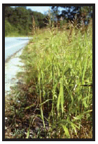
Johnsongrass was spotted
at 55mph in northwest
Arkansas.
CANADA THISTLE: Look for light lavender bloom in small, irregular patches. The soft, silky grayish seed heads rise above surrounding
plants. By the time you see them blowing, you have a problem.
JOHNSONGRASS: This bunchgrass shows up as lighter in color than native perennial grasses like Big bluestem. This vigorous grass resembles
sudangrass and grows 2-8 feet high. Its dark reddish-brown seed heads will catch your eye. Johnsongrass quietly fades from light green to tan in the fall.
SPOTTED KNAPWEEDS: At first sight, knapweeds can be confused with Canada thistle because of their soft lavender hues. Before blooming,
the colonies are noticeable by their blue-green-gray leaf color. Plants are straggly and many-branched. During fall and winter, knapweed patches appear
dusty/dirty and seeds are easily spread by mowers.
LEAFY SPURGE: In the spring, the leaves are light green with lime or fluorescent green flowers you can see from far away. This perennial
forms large masses. In the fall you can flag them easily because of their soft salmon or pastel red-orange color.
BERMUDAGRASS: This wiry, perennial grass creeps and forms large colonies across the southern States, and increasingly in the West. Its
upright flower stems cause it to be confused with crabgrass. It grow as large mats of short, even stands that turn a boring brown over winter. It is one
of the last to green up in the spring.
PURPLE LOOSESTRIFE: This bright magenta perennial is easy to see from a distance in wetland areas or swales for many summer weeks. You
can spot it without flowers, as masses of darker green color, with or strong upright structure contrasted against wetland grasses, sedges and cattails.
Flag dark brown patches in the fall.
SOW THISTLE: This expanding perennial (or it’s annual form) is a striking sunny yellow that appears as bright as yellow caution signs.
Repeated mowing seems to string them down the shoulder edge. This 3-6’ erect weed has small dandelion-like fluffy seed heads.
KUDZU: Easiest of all! These big-leafed vines crawl over most everything in sight, including trees, utilities and abandoned buildings.
Because kudzu has become hardy to colder climates, all States should watch for the large, three-lobed dark green leaves.
SWEET CLOVER; Yellow or white species form lose delicate masses with small flowers and leaves. Their bushy structures sway in natural
or vehicle-made wind gusts.
HOW AND WHY TO PREVENT SPREAD OF AQUATIC WEEDS
Excerpted from Operational Guidelines for Aquatic Invasive Species Prevention and Equipment Cleaning for Firefighters, US Forest Service. August
2009.
Giant salvinia is an aquatic plant threatening the lower Colorado River. These aquatic weeds occur in aquatic, riverine, or wetland environments and can
be spread by fire equipment as well as highway corridor maintenance or construction equipment. Executive Order 13112 directs all federal agencies to ensure
that their actions do not promote the introduction or spread of invasive species. SAFETEA LU, Section 6006-329 further allows federal-aid funds for State
Transportation to be used to control noxious weeds, including aquatic weeds. Because these invasive plants and animals have impacts on natural resources,
environmental stewardship objectives encourage the limit of spread and/or prevention as first line defense.
HOW TO PREVENT SPREAD:
1. For all operations, assume aquatic weeds could be present in any water body.
- Work with local land management agencies and State resource agencies to obtain species-specific information and distribution maps.
- Include these species in corridor inventories and GIS systems.
- Train crews to identify both plant and animal invasive species.
2. Avoid driving through water bodies or contacting mud with vehicles or equipment.
3. Avoid transferring water between drainages.
4. Avoid frequent ditch cleanings, and/or clean equipment often.
HOW TO CLEAN VEHICLES AND EQUIPMENT:
Any equipment that comes in contact with the water of retention ponds, ditches, wetland mitigations, etc. can accidentally pick up invasive species larvae
or propagules. Air-drying can be enough to kill some, but washing between project sites is essential. Consider tagging vehicles and equipment to advise
the next user this equipment has been cleaned. Truck/tractor record-keeping can also help.
References Cited:
FHWA/USDOT, 2009. Common Roadside Invasives, A Field Guide to Costly Aquatic Weeds. Pub. No. FHWA-HEP-09-016 Washington D.C.
https://nas.er.usgs.gov/
USGS Nonindigenous Aquatic Species website with real time distribution maps.
http://www.fs.fed.us/eng/pubs/pdf/WaterToolkit/o1_06251806.pdf
Forest Service guidance and other tools for invasive aquatic species.
http://www.ProtectYourWaters.net
aims to stop aquatic hitchhikers with current news updates.
http://www.100thMeridian.org
guards against the westward spread of all invasive species.
HOW TO WRITE A NEPA/INVASIVE STATEMENT
BENEFITS:
- Avoid foreseeable vegetation problems.
- Assure invasive seed mixes are not used.
- Precede construction with weed control.
- Avoid unnecessary soil disturbances.
- Plan and budget for after-project monitoring.
SITE ANALYSIS:
1. Identify existing invasive species on site and adjacent lands.
2. Consult with State agriculture and natural resource experts.
3. Include DOT vegetation mangers in analysis.
4. Estimate the potential economic and ecological impacts.
5. Consider ways to limit the spread of invasives during project.
THRESHOLDS:
Base threshold levels on the State’s noxious weed law/invasive plant list. Potential threats are impacts within and adjacent to project.
- Loss of endangered species.
- Loss of crop production.
- Loss of wildlife habitat.
- Devalued hunting lands.
- Exposure to slope failures.
- Loss of tourism values.
- Loss of stormwater function.
- Degraded parklands.
- Increased fire vulnerability.
- Loss of biodiversity.
RECOMMENDATIONS:
1. Ask for weed-free mulch, bermed topsoils, certified gravel pits, native seed mixes, and weed control before project.
2. Suggest native plant specifications for temporary seedings, erosion control, and landscaping.
3. Require and fund a management plan for care of the project.
4. Require special provisions to prevent and control invasive plants.
EXECUTIVE ORDER 13112 INVASIVE SPECIES
On February 3, 1999, President Clinton signed EO 13112, directing federal agencies to expand and coordinate their efforts to combat the introduction and
spread of invasive plants and animals not native to the United States. The Federal Highway Administration (FHWA) delivered guidance to the field on August
10 of that year.
EO13112 SYNOPSIS:
Section 1. Definitions
The key definition of invasive species is “an alien species whose introduction does or is likely to cause economic or environmental harm or harm
to human health.” This definition parallels that of noxious weed law in most States.
Section 2. Federal Agency Duties
This section called agencies to action within programs and budgetary limits to:
a. prevent the introduction,
b. detect and control quickly,
c. monitor existing populations and managed areas,
d. follow-up with restoration of native species,
e. conduct research and develop prevention and control technologies, and
f. promote public awareness.
Federal agencies were further directed to not authorize, fund, or carry out actions that cause or promote the introduction or spread of invasive species.
FHWA oversees the Federal-Aid Highway Program and so complied.
Section 3-4. Invasive Species Council EO 13112 created the National Invasive Species Council (NISC) with an Advisory Committee to recommend management
plans and actions at all levels of government. Until States devised their own plan, the NISC plan prevailed for DOTs.
FHWA GUIDANCE:
- Federal-aid and Federal Lands Highway program funds cannot be used for construction, revegetation or landscaping activities that include use of known
invasives.
- NEPA analysis should include determination of the likelihood of introducing or spreading invasives and a description of measures to minimize harm, based
on inventories.
- State DOT activities and funded facilities were asked to implement the Executive Memorandum on Beneficial Landscaping to support EO 13112, Section 2-d
to use native plants. FHWA recommended roadside maintenance program support.
- FHWA encouraged innovative design in techniques and equipment like biocontrol delivery systems, equipment cleaners and GPS for vegetation inventories.
- FHWA promised to coordinate applied research and share results with all agencies.
- FHWA would support training like identification materials and CWMA workshops. FHWA recommended DOTs join their States interagency cooperation through
invasive species councils, and cooperate with adjacent State DOTs to prevent invasive spread.
- FHWA continued federal committee cooperation with FICMNEW, NPCI, and ANS.
Back to top
CHAPTER 5
ROADSIDES FOR WILDLIFE
WHY MINIMIZE ROAD IMPACTS TO WILDLIFE?
Excerpted from Getting Up To Speed: A Conservationist’s Guide to Wildlife and Highways by Patricia A. White, Defenders of Wildlife. Washington
D.C. 2007.
Perhaps the best overview of impacts was the sentinel article, Review of Ecological Effects of Roads on Terrestrial and Aquatic Communities by
Stephen Trombulak and Christopher Frissell first published in The Journal of Conservation Biology in April, 2000. They grouped impacts into seven categories:
1. Mortality from road construction.
2. Mortality from collision with vehicles.
3. Modification of animal behavior.
4. Disruption of the physical environment.
5. Alteration of the chemical environment.
6. Spread of exotic species.
7. Changes in human use of land and water.
Avoiding wildlife habitat loss should be the first approach, but mitigation efforts can substantially reduce roadkill. In Banff National Park, British
Columbia, a series of 22 underpasses and two overpasses with fencing have decreased total roadkills by 80 percent. Consequently the lives of wolf, grizzly
bear, elk, lynx, mountain lion and moose have been protected.
British Columbia collects wildlife accident data daily. For each incident, workers record the date, time, location, species, sex and age of the roadkill.
This information is then used to determine the type and location of warning signs, fencing and crossing structures.
Habitat connectivity describes the degree to which landscape characteristics facilitate or impede the ability of an organism to move on a daily, seasonal
or life cycle basis. Wildlife movement to reach resources like food, water, cover and mates needs to be better understood. Preparing statewide or regional
plans for habitat connectivity is essential.
In order to prepare a wildlife habitat linkage plan, be sure to collect this information:
- Aerial photos identifying vegetation, human developments, water bodies, aspect and terrain, and possibly existing wildlife trails.
- Land ownership maps to identify public lands.
- Vegetation maps that note general vegetation types.
- Topographic maps to show slopes, draw, ridges and flats that could be part of corridors.
- Wildlife habitat or range maps to better understand movement.
- Wildlife behavior monitoring to determine where animals cross.
- Existing roadkill information for further safety insight.
NOTE: Cross-check the wildlife habitat linkage plan with the Statewide Transportation Improvement Plan. Identify which pending projects overlap with key
linkage areas and move to have wildlife mitigation measures added to the scope of projects.
References Cited:
SAFETEA-LU Wildlife Vehicle Collision Study https://www.fhwa.dot.gov/publications/research/safety/08034/08034.pdf
Deer-Vehicle Crash Information Clearinghouse (DVCIC) http://www.dearcrash.com/
British Columbia Conservation Foundation’s A wildlife Collision Prevention Program http://www.wildlifeaccidents.ca/
Highways and Habitat: Managing Habitat Connectivity and Landscape Permeability for Wildlife,
http://www.fs.fed.us/pnw/sciencef/scifi79.pdf
The Wildlife Crossings Toolkit http://www.wildlifecrossings.info/
FHWA’s Critter Crossings http://www.fhwa.dot.gov/environment/wildlifecrossings/
WILDLIFE PROTECTION CASE STUDIES
We have more to learn, as described by Stephen Trombulak and Christopher Frissell in the 2000 Journal of Conservation Biology, “Review of Ecological
Effects of Roads on Terrestrial and Aquatic Communities”. The authors group potential impacts of roads on wildlife into seven categories, which
are listed on page 183.
Highway projects destroy wildlife habitat, interrupt animal movements, and put animals in harms way. For human and wildlife safety, we look for new answers
constantly. Based on the observations of many vegetation managers, we suspect that newly mowed turfs actually attract some species to the road’s edge.
Some States already have reduced mowing policies to reduce the loss of nesting game birds often found in corridors. Some States actually have “Roadsides
for Wildlife” programs focused on the needs of wildlife. The following section will share some of what has been learned.
ARKANSAS HIGHWAY AND TRANSPORTATION DEPARTMENT (AHTD): The AHTD revised its mowing schedules and established roadside “high maintenance
zones” and “transition zones”. On particularly wide rights of way the Department also created “natural zones” beyond the
“transition zones”. These natural areas are never mowed. The no-mowing policy has helped increase available wildlife habitat on more than
30,000 acres. Birds and butterflies flock to the now-flourishing native wildflowers in these natural zones, and many wildlife species utilize the habitat.
SOUTH DAKOTA DEPARTMENT OF TRANSPORTATION: The SDDOT abides by a policy that restricts mowing on public roads until the end of the nesting
season. Reduced mowing protects game birds that nest in the dense right-of-way grasses until they can protect themselves. This policy protects both native
and non-native birds that are important to the economy and ecology of the State.
WISCONSIN DEPARTMENT OF TRANSPORTATION: The State of Wisconsin hosts the largest population of Karner blue butterflies in the world.
Because its preferred host, wild blue lupine, is scarce, the Karner blues have become endangered. The DOT partnered with 22 public and private organizations
to preserve existing lupine patches and establish new plantings. The DOT also reduced mowing along 500 miles of roadsides to further protect this butterfly.
References Cited:
Keeping it Simple, Easy Ways to Help Wildlife Along Roads. U.S. Department of Transportation, Washington D.C. Nelson, Carmelita, 2009. Personal
communication.
Trombulak, S.C., and C. Frissell, 2000. “A review of the ecological effects of roads on terrestrial and aquatic ecosystems.” Conservation
Biology 14:18-30.
Keeping it Simple means doing the right thing simply to link habitats, reduce roadkill, and save taxpayer dollars.
HOW TO MANAGE FOR WILDLIFE HABITAT
Studies show that native roadsides attract twice as many bees and almost 50 percent more bee species than roadsides with nonnative grasses. Similar results
were shown for butterflies. In addition grassland birds will nest successfully in narrow corridors. In Nebraska, 25% of all pheasants hatch on roadsides.
Roadsides often become edge habitat in forested regions, and thereby serve as conservation corridors to larger habitat patches. In some intensely cultivated
areas, roadsides are the only grasslands habitat available.
BENEFITS:
- Create habitat for other purposes.
- Increase habitat for wildlife and water fowl in your region.
- Protect pollinators, song birds and small mammals.
- Save maintenance dollars with reduced mowing and spraying.
- Protect regional natural heritage and scenic quality.
HABITAT GOALS:
- Protect what you have and do no harm!
- Enhance areas degraded by invasive species.
- Restore native plants preferred by native wildlife, especially pollinators.
- Reduce wildlife-vehicle crashes.
- Increase biodiversity buffer and safe passage.
How to Do It:
CONSULT EXPERTISE of your State conservation agency and the Fish and Wildlife Service.
MOW LESS: Roadsides that have not been mowed for 3-5 years have up to three times as many nests per acre as those mowed annually. 3-year
mowings will control brush.
ADD HABITAT: Establish native grasses and forbs; but avoid red clover, alfalfa, sweet clover and similar species that attract deer or
other large animals.
SPOT SPRAY: Avoid spraying native plants and wildlife, especially petroleum-based carriers that can permeate egg shells, and kill the
embryo.
DELAY MOWING until after birds have fledged.
MAINTAIN FENCES and provide safe passage. Fencing can channel wildlife traffic for mating or migrating seasons. Clear debris from underpasses
and other crossings.
PLANT NATIVE WILDFLOWERS that bloom over time to benefit pollinators and highway users.
PLANT NATIVE DIVERSITY AFTER ERADICATING INVASIVE PLANTS to benefit a diversity of wildlife.
PARTNER WITH CONSERVATION GROUPS like Pheasants Forever, Bluebird Recovery Program, Wildlife Forever, Audubon Society, etc
INVENTORY VEGETATION to locate and protect special wildlife habitats.
References Cited:
Dumke, R.T., and C.M. Pils. 1979. Renesting and dynamics of nest site selection by Wisconsin pheasants. Journal of Wildlife Management, 43:705-716.
Federal Highway Administration. 2003. Keeping It Simple - Easy Ways to Help Wildlife Along Roads. Pub. No. FHWAEP-03-066, Washington D.C.
Hopwood, Jennifer. 2008. Biological Conservation. University of Kansas. Nelson, Carmelita, 2009. Personal communication.
White, Patricia A. and Michelle Ernst. 2005. Second Nature, Improving Transportation Without Putting Nature Second. Defenders of Wildlife. Washington
D.C.
HOW TO REDUCE DEER-VEHICLE COLLISIONS (DVC)
Deer-vehicle collisions are a worldwide problem. Annual vehicle-related mortality of deer is estimated at 500,000 to 750,000 animals, and the economic
value of each deer for hunting is between $500-1000. However, it is human safety and property damage that prompt our vegetation management decisions.
Deer are in highway corridors for one of two reasons: they are attracted to a resource like salt or forage, or they are crossing the road to another resource.
Disturbances like blading or frequent low-height mowing attracts deer to the new forage growth. These practices can be limited.
Humans can reduce the risk of accidents by slowing down in signed deer crossing areas. However, warning signs and highway lighting have not proven to
lower drivers’ speeds. Studies show that more light, larger clear zones, and/or less vegetation simply encourage drivers to drive faster. Drivers
would benefit from understanding deer behavior, especially daily movement patterns and mating or migration seasons. Public awareness can be increased.
What vegetation management cannot accomplish, fencing and underpasses have helped. However, deer can be trapped inside the fencing, causing havoc. Underpasses
work in locations where deer naturally travel along streams, rivers and low-lying areas. They prefer earthen floors, short and open underpasses with a
height and width of 15 feet. Planting of palatable species and shrubs near the structures can help direct deer through underpasses.
The Deer-Vehicle Crash Information and Research Center is home to a pooled fund transportation project. Eight State DOTs are taking part in their research.
You can become a pooled fund member by visiting the website below.
References Cited:
Danielson, B.J., and M.W. Hubbard. 1998. A literature review for assessing the status of current methods of reducing deer-vehicle collisions.
Report to Iowa’s DOT and DNR. Iowa State University, Ames.
Deer Vehicle Crash Information Clearinghouse at http://www.deercrash.com/
Durbin, Dennis. 2009. Personal communication.
Gray, Mary. 2009. Personal communication.
Johnson, Ann. 2008. Best Practices Handbook for Roadside Vegetation Management. Minnesota State University, Mankato.
Johnson, C.W., L. Anderson. 1997. Utah’s Rural Roadsides for Wildlife Program: A Technical Manual. Utah State University, Logan.
Romin, L.A., and J.A. Bissonette. 1996. “Deer-vehicle collisions: status of state monitoring activities and mitigation efforts.” Wildlife
Society Bulletin 24: 276-283
Simberloff, D., and J. Cox. 1987. “Consequences and costs of conservation corridors.”
Conservation Biology 1:63-71.
HOW TO PROTECT MIGRATORY BIRD SPECIES
SUMMARY OF THE TREATY ACT:
- Meadow larks, bobolinks and other migratory grassland birds are facing serious population declines. Roadside grasslands are often one of the last habitats
for them.
- The 1918 Migratory Bird Treaty Act (MBTA) prohibits the “take” of listed birds, their nests, eggs or young (50 CFR 10.13).
- Protects all birds, except exotics, that cross international border.
- Requires permit or license from the U.S. Fish and Wildlife Service.
- An MOU between FHWA with USFWS is under consideration, and a manual to follow.
Proposed roadside vegetation management methods can include:
1. Encourage establishment of native plants.
2. Control invasive plant species.
3. Avoid or minimize the use of herbicides.
4. Consider adjacent land use and ecosystems as habitat.
5. Note wetland and ROW stream corridors as attractions.
6. Use GIS to inventory and monitor management.
BENEFITS:
- Avoid costly construction delays.
- Avoid accidental “takings” of birds by mowers.
- Improve wildlife habitat protection.
- Increase public awareness and support.
NOTE: The timing of mowing is critical in vegetation management work. Avoiding bird nests and young birds that have not fledged is required by
MTBA. During spring and summer, one strategy would be to mow only one edge swath to avoid an accidental “take”. After the birds have flown
on, a more complete mowing is allowed to control invasive plants, unless prohibited by State law. The States of Arkansas, Iowa, Nebraska, South Dakota
and Minnesota limit mowing and manage the timing of any mowing to avoid wildlife conflicts. Construction projects have come to a halt to accommodate nesting
swallows during bridge work. Be aware and plan for bird migrations that could conflict with upcoming projects.
References Cited:
Garrett, Paul, 2009. Personal communication.
Migratory Bird Treaty Act of 1918 and relevant updates www.fws.gov/laws/lawsdigest/migtrea.html
HOW TO PROTECT POLLINATORS
Planting native vegetation on roadsides has inadvertently protected many pollinators for decades, roadsides with native vegetation. Twelve roadsides with
native plants in Iowa were surveyed for abundance and species richness of disturbance-tolerant and habitat-sensitive butterflies. This survey was compared
to a nearby roadside dominated by nonnative legumes and/or grasses. The species richness of habitat-sensitive butterflies increased two-fold on the
restored rights-of-way as compared to the nonnative roadsides. Tracking studies also determined that butterflies were less likely to leave restored roadsides,
implying less roadkill and the potential for roadsides to be used as corridors by these insects. Perhaps highway corridors can continue to serve as pollinator
habitat into the future. After all, most roadsides border adjacent farmlands and agriculture needs pollinators to survive. The North American Pollinator
Protection Campaign (NAPPC. org) has raised national concern about the loss of pollinators. NAPPC contends that insect pollinators produce nearly $20
billion worth of products annually. Pollinators have decreased in numbers due to habitat loss, pesticide misuse, and the spread of invasive species. Beetles,
bees, ants, wasps, butterflies and moths pollinate the largest number of plant species. Hummingbirds, bats and small mammals help out. They are all necessary
to life as we know it.
A call for national policy is in the wind. Federal agencies are focusing on pollinators and signing Memorandums of Understanding for unprecedented cooperation.
Pollination ecology is not yet widely studied. More research is needed. A national inventory of pollinators could define a benchmark to determine if they
need special protection. Monitoring of global trends will also be necessary per the “Ten Point Plan” described by Buchmann and Nabhan in The
Forgotten Pollinators. It could be far easier to adopt a protection plan than to adapt to a world without pollinators.
WISDOT is one of 41 partners in the Habitat
Conservation Plan to protect endangered
Karner Blues and restore their preferred habitat.
IS THERE A ROLE FOR ROADSIDES?
Why not? Wherever native vegetation exists on roadsides, pollinators likely use it. Pollinators are an important reason to plant more native vegetation
where appropriate in each State. Recently, the Wisconsin Department of Transportation was approached by a local coalition of 22 groups to protect the
endangered Karner blue butterfly. The Karner blue is specific to a native lupine in Wisconsin and was ripidly losing suitable habitats. By reducing mowing
on 500 miles of roadsides, the state created significant additional habitat. No money was spent and maintenance costs were reduced. The DOT took a further
step and deliberately planted the native lupine with other native grassland species to expand habitat for this special butterfly. The cost was not huge,
but public good will was.
References Cited:
Buchmann, Stephen L. and Gary Paul Nabhan,1996. The Forgotten Pollinators. Island Press, Washington D.C.
Marinelli, Janet, 2008. The Wildlife Gardener’s Guide. Brooklyn Botanic Garden, NY.
Merriman, James, 2009. Personal communication - Wisconsin DOT. Pollinator Partnership, http://www.pollinator.org
Ries, Leslie, Diane M. Debinski, Michelle L. Wieland, 2001. “Conservation Value of Roadside Prairie Restoration to Butterfly Communities”.
Conservation Biology 15:2, 401-411, Blackwell Science, Inc. Boston.
Back to top
PART 6
ON-THE-GROUND APPLICATIONS
INTRODUCTION
Common Sense Tools
“In the present times of shrinking funds for transportation agencies, the trend in roadside management has been toward the ecological approach.”
Dr. L. Foote, Director
Environmental Studies,
MnDOT 1975.
And here we go again, more than three decades later. Our economy has faltered. Fuel costs have skyrocketed. In the seventies, some States responded with
an ecological look at vegetation management. Will this be the time when all State Departments of Transportation embrace an ecological approach? Perhaps
if we had only called it “the common sense approach” to begin with, we might already be adept during changing economic climates. After all,
an ecological approach is based on how we connect with nature and the ecosystem services nature provides us. Understanding these connections equates to
common sense. During settlement, it was common sense to try to control wildfires to protect new towns. What we did not understand was that by halting
wildfires, there were consequences in nature. Later, we understood the importance of fire in how forests, grasslands, and wetlands function and used our
common sense to reintroduce controlled fires.
This is not a condemnation of our ancestors, the early settlers. They did the best they could with the knowledge they had at the time. Now we understand
much more about how our environment works and what the consequences of disturbance are. Our common sense has increased. This book does not choose the
environment over humans; but rather connects the needs of both with solutions that can work for both not with one size fits all, but with an integrated
approach.
Climate change will push us to make more common sense decisions and adapt to unknown situations. The better we understand how the human and natural environments
are connected, the more we will succeed.
This book provides hope for the future, for our relationship with the environment, and for the survival of our changing human and natural environment
over time, as long as we implement an ecological approach or informed common sense.
Back to top
CHAPTER 1
BASIC MOWING STRATEGIES
HOW TO REDUCE MOWING
BENEFITS:
- Reduce fuel cost.
- Reduce emissions.
- Protect nesting wildlife.
- Protect native remnants.
- Improve maintenance safety.
Roadside mowing has been part of the highway landscape since the 1930s. Mowing with horses cost 50 cents per mowing mile swath. In the 1940s, highway
agencies transitioned to trucks with sickle bars and herbicide application to lower the cost of roadside maintenance.
In the 1980s, wildlife groups observed that many roadside-nesting game birds were killed by mowers before young birds could fledge. In response, the Minnesota
and Michigan legislatures required a reduction of mowing by transportation entities throughout rural roads, including interstates. They allowed only one
mowing swath to keep the rights-of-way safe and clean. The only flexibility was a one month window in the fall season to mow any part or all of the right-of-way.
This allowed maintenance to stop tree/shrub and exotic plant encroachment. Reduced mowing has worked well and has not produced public pushback. A
number of State DOTs are reducing mowing without regulation for the same reasons and to add a measure of common sense to their workload. For example,
Wisconsin has reduced mowing by strategically timing their mowing efforts. This has led to the protection of endangered Karner Blue butterflies. The complete
1989 Minnesota statute is available online (https://www.revisor.mn.gov/laws/?doctype=Chapter&year=1989&type=0&id=179)
along with the most recent version of the statue (https://www.revisor.mn.gov/statutes/?id=160.232).
NOTE: Studies of old field succession show that to deter woody invasion, forested regions of the U.S. do not require mowing more than once every
five years. Use your understanding of regional succession (see page 173 “Roadside Succesion”) to reduce costs and wasted time. The benefits
listed above will be your reward.

In the 30s, mowing was reported to cost 50 cents
per lane mile. Savings were found by attaching
the blade to a truck.
References Cited:
Collins, Beryl Robichaud and Karl H. Anderson. 1994. Plant Communities of New Jersey. “The Natural Change of Vegetation in Time”,
13-17. Rutgers University Press, New Brunswick.
Stark, Richard. 2007. “Mowing Timeline”, page 37 in Roadside Weed Management, Federal Highway Administration, Washington D.C.
Subcommittee on Roadside Development Economics, 1940. Nineteenth Annual Meeting by the Joint Committee on roadside Development, Highway Research Board,
and American Association of State Highway Officials. Washington D.C.
Harper-Lore, B.; M. Johnson; M. Skinner, Eds. 2007. Roadside Weed Management, U.S. DOT, FHWA. FHWA-HEP-07-017. http://www.weedcenter.org
Minnesota’s Reduced Mowing Law
A Model Since 1985
2011 Minnesota Statutes:
160.232 MOWING DITCHES OUTSIDE CITIES
(a) To provide enhanced roadside habitat for nesting birds and other small wildlife, road authorities may not mow or till the right-of-way of a highway
located outside of a home rule charter or statutory city except as allowed in this section and section 160.23.
(b) On any highway, the first eight feet away from the road surface, or shoulder if one exists, may be mowed at any time.
(c) An entire right-of-way may be mowed after July 31. From August 31 to the following July 31, the entire right-of-way may only be mowed if necessary
for safety reasons, but may not be mowed to a height of less than 12 inches.
(d) A right-of-way may be mowed as necessary to maintain sight distance for safety and may be mowed at other times under rules of the commissioner, or
by ordinance of a local road authority not conflicting with the rules of the commissioner.
(e) A right-of-way may be mowed, burned, or tilled to prepare the right-of-way for the establishment of permanent vegetative cover or for prairie vegetation
management.
(f ) When feasible, road authorities are encouraged to utilize low maintenance, native vegetation that reduces the need to mow, provides wildlife habitat,
and maintains public safety.
(g) The commissioner of natural resources shall cooperate with the commissioner of transportation to provide enhanced roadside habitat for nesting birds
and other small wildlife.

The conservation organization,
Pheasants Forever,
supported the reduced
mowing law to protect
wildlife habitat during nesting.
Minnesota’s rural reduced mowing act has been in effect since 1985. The adoption of this law was driven by Pheasants Forever and their concern about diminished
pheasant habitat in the Midwest. The law was written in recognition that roadside corridors provide habitat for many nesting birds including songbirds
and other small wildlife. Ironically, these corridors have also proven to be refuges for threatened and endangered species like the prairie fringed orchid
in Minnesota, foamflower and fairy shrimp in California, the gopher tortoise in Mississippi, bog turtles in Maryland, pitcher plants in Virginia and the
Karner Blue Butterfly in Wisconsin.
In addition to benefiting wildlife conservation, reduced mowing potentially reduces annual maintenance costs and carbon emissions from mowers. In our
changing future, less mowing could result in increased carbon sequestration in highway rights-of-way, thus increasing roadside conservation value even
more. Because the traveling public has not objected to one mowing swath along the pavement and driving safety is not compromised, more States might consider
the Minnesota model.
Back to top
CHAPTER 2
BASIC SPRAYING STRATEGIES
GOALS:
- Assure personnel safety.
- Protect water supplies.
- Avoid crop damage.
- Protect wildlife habitat.
- Eradicate noxious weeds.
- Reduce management costs.
- Strengthen an integrated approach.
- Be a good neighbor.
Although we have a number of management tools, herbicides remain one of the most cost-efficient. For some weed species, herbicides are the only answer
at this time. Thanks to the herbicide industry for all the training they make available to Federal, State, County and Municipal agencies. Every applicator
training I have experienced begins with two basics: applicator safety and herbicide labels. This section will not attempt to simplify the important aspects
of calibration, equipment, efficacy rates, mixing, application or disposal of herbicides, but rather encourage these annual training sessions to keep
personnel and contractors up to date and safe. I suggest that more plant identification training be given to avoid spraying mistakes. Good record-keeping
is critical to prove our success. An annual vegetation management plan can guide your work to efficiently use limited budgets and demonstrate value.
Base your plan on vegetation inventories of all rights-of-way in order to plan wisely, and to document success or a need to return to a site. We are responsible
for protecting our people, our rights-of-way and our larger environment. All we do on rights-of-way is visible and accountable to the public. Use your
best common sense!
NOTE: When the public understands our constraints with vegetation management, they are likely to support the use of herbicides like the New Jersey Audubon
Society (NJAS) did in 2006. NJAS supports the use of herbicides in activities where ecological restoration or wildlife habitat management is the objective
and when no other effective alternative is available.
References cited:
National Cooperative Highway Research Program 14-16, 2009. Ian Heap, Et Al. Vegetation Management Guidelines. Transportation Research Board, Washington
D.C.
Industry representatives are available for training and research projects.
HOW TO SPOT-SPRAY NOXIOUS WEEDS
Hundreds of dollars worth of goodwill and wildflowers can be destroyed by not sticking to the spot spraying policy. Nebraska Department of Roads.
Blanket-spraying is common in some States. The public is not impressed and complains often when they see vegetative cover replaced by soil erosion and
invasive plants. We can do better. Killing all vegetation to eradicate a noxious weed is not effective over time, increases weed infestations, and it
is an eyesore to the traveling public. By spraying all vegetation, we lose benefits plants provide in the rights-of-way. The only vegetation that will
return are the species in the soil seed bank and that often means more invasive plants. Blanket spraying is no longer an option.
BENEFITS:
- Eradicate only noxious weeds.
- Protect nesting wildlife.
- Avoid most pollinators.
- Save herbicide dollars.
- Improve public relations.
- Avoid agriculture complaints.
- Avoid chemical-sensitive neighbors.
In order to have an effective spot-spraying program, crews or contractors must be well-trained. Applicators actually have to be able to identify the noxious
weed species they are targeting. They must also be able to identify vegetation to avoid, like endangered species, native remnants, and native wildflower
plantings. While this increases required training time, it reduces compliance time and ecological losses. Spotspraying requires more skill with equipment
and therefore the more experienced applicators must lead efforts.
Spot-spraying records must be kept and assessed. This is when GPS will be useful to internal forces or contractors. GPS data can help protect locations
to avoid as well. The location of the noxious weeds can require different control products and methods. Of course, each noxious weed is vulnerable to
different herbicides. Learning the best solution comes with experience and research. Check for expertise with your State Department of Agriculture and
within your DOT. Two examples are provided below. Also note species-specific solutions in this book on the following pages.
References cited:
Johnson, Ann M. 2008. Best Practices Handbook for Roadside Vegetation Management. Minnesota State University, Mankato.
Nebraska Department of Roads. 2009 Roadside Vegetation Establishment and Management. Lincoln, NE.
Utah’s on-board GPS provides accurate
record-keeping as a benchmark for
future management.
HOW TO MINIMIZE HERBICIDE RESISTANCE
Experts agree that there are currently more than 300 herbicide resistant weed species in North America, with even more on their way to becoming resistant.
If you count on herbicides to do your job, it is not so important to know how and why certain plants become resistant. However, some plants are being
impacted by a change in climate and are becoming resistant. This is not something you can control. But you can minimize resistance by the practices you
chose. Knowing some basic principles for the wise use of herbicides helps you avoid resistance problems.
KOCHIA RESISTANCE:
Several years ago, a new, highly touted family of herbicides was used extensively to solve agricultural and roadside weed problems in the West. Extremely
effective at controlling (nearly 100% control) Kochia and several other common weeds, many state and local agencies, professional herbicide contractors,
and farmers rapidly adopted these herbicides, prompting widespread use. Unfortunately, because we ignored a few principles, resistant Kochia spread rapidly
and uncontrollably throughout the West, becoming a serious crop, safety and fire-danger problems.
It took industry, applicators, weed scientists, and other users to collectively develop solutions. In the meantime, many commercial applicators faced
huge financial losses and the credibility of roadside management plans suffered greatly. You can help avoid a similar fate by using these few simple rules:
- Avoid favoring one management strategy. Mix it up by using integrated management: mowing, prescribed burns, biological controls, tank mixes, rotational
treatments, or even let the area lie fallow for a year.
- Watch for weeds less susceptible to your treatment to re-appear. Not all plants that look alike are the same ecotype. Avoid controlling one noxious weed
while unknowingly encouraging the spread of another. Good plant identification and monitoring are required.
- Monitor and eradicate the small percentage of a weed population that the herbicide does not affect. Their offspring are likely to be resistant and reproduce.
- Avoid repetition of a selective herbicide, tank mix, or herbicide with the same mode of action. Historically, the most problematic resistant weed species
we deal with are the result of over-using herbicides with the same or similar modes of action.
- Share your experiences with other vegetation managers. Keep up with the information provided by contractors, suppliers, and the agricultural community
in your area.
- “As CO2 carbon dioxide increases, glyphosate efficacy is reduced.” And as levels change, invasives are likely to increase. We can no longer
assume that what worked in the past will work in the future. (Ziska, 2004)
References cited:
http://www.extension.umn.edu and other University Extensions report research.
http://www.wssa.net - Weed Science Society of America show list of 332 ecotypes.
http://www.ars.usda.gov - research on herbicide resistance
Lore, Gary, 2009. Personal communication. Ziska, Lew, 2004. “Climate Change and Invasive Weeds” Weed Science 52:584-588
Back to top
CHAPTER 3
HOW TO CONTROL 40 COMMON INVASIVE PLANTS
Species chosen by the authors of NCHRP 14-16 are described with specific treatments for each, including effective chemical and non-chemical controls.
See the NCHRP document for specific methods, rates and timing. Other references are available for identification of species in the field.
AUTUMN OLIVE, (Elaeagnus umbellata)
- Chemical control: triclopyr, glyphosate, dicamba and 2,4-D.
- Non-chemical: Pull seedlings; cut trees and treat, or girdle.
BERMUDAGRASS, (Cynodon dactylon)
- Chemical control: fluazifop, glyphosate, sethoxydim.
- Non-chemical: cultivate 2-3 times and remove vegetative parts.
- Shading by other plants and/or mulches to suppress growth.
BIRDSFOOT TREFOIL, (Lotus corniculatus)
- Chemical control: aminopyralid, clopyralid, 2,4-D, triclopyr.
- Resistant to glyphosate.
- Non-chemical: repeated clipping reduces seeds and weakens roots.
BLACK LOCUST, (Robinia pseudoacacia)
- Chemical control: glyphosate, triclopyr, picloram or fosamine.
- Non-chemical: mechanical cutting or girdling only if repeated or herbiciding fresh-cut stems. The black locust borer does damage in its native Appalachian
region. No USDA approved biocontrols exist.
BUFFELGRASS, (Pennisetum ciliare)
- Chemical control: fluazifop, glyphosate, hexazinone, or tebuthiuron.
- Non-chemical: mowing and burning in combination with herbicide.
- Heavy grazing makes plant susceptible to chemical treatment or drought.
CANADA THISTLE, (Cirsium arvense)
- Chemical control: aminopyralid, chlor sulfuron, clopyralid (+), dicamba, glyphosate, metsufuron methyl, picloram, triclopy (+).
- Non-chemical: repeated mechanical methods; multiple mowings, sheep and goat grazing reduces seed production, well-timed burning with other; competitive
plantings, and several bio-controls.
CHEATGRASS/DOWNY BROME,(Bromus tectorum)
- Chemical control: atrazine, fluazifop, glyphosate, imasapic, paraquat, pronamide, quizalofop, sethoxydim, sulfometuron.
- Non-chemical: shallow disking after germination; burning (after plants have dried only); moderate grazing and revegetation with competitive species in
combination.
CHINESE TALLOWTREE, (Sapium sebiferum)
- Chemical control: glyphosate, triclopyr, imazapyr, fosamine, or hexazinone.
- Non-chemical: cut trees at ground level and treat resprouts.
COGONGRASS/SPEARGRASS, (Imperata cylindrical)
- Chemical control: fluazifop, glyphosate(+), or imazapyr.
- Non-chemical: tillage or mowing in combination with herbicide.
- Revegetation after control and burning prior to herbicide.
COMMON BUCKTHORN, (Rhamnus cathartica)
- Chemical control: glyphosate, triclopyr, fosamine, picloram, or hexazinone.
- Non-chemical: pulling, mowing with herbicide of re-sprouts.
COMMON REED, (Phragmites australis)
- Chemical control: glyphosate, imazapyr, fluazifop-P.
- Non-chemical: cutting and flooding possible on some sites.
CROWNVETCH/TRAILING, (Coronilla varia)
- Chemical control: aminopyralid, clopyralid, 2,4-D, glyphosate, metsulfuronmethyl, and triclopyr.
- Non-chemical: remove manually or by cutting or burning, then treat cut stems; revetetation, late spring prescribed burns, grazing in combination only.
DIFFUSE KNAPWEED, (Centaurea diffusa)
- Chemical control: aminopyralid, clopyralid (+), e,4-D, dicamba (+), glyphosate, picloram (+).
- Non-chemical: mowing before seed set, minimize disturbances, 2 years of prescribed burning, livestock grazing, and numerous biocontrol insects.
DYERS WOAD, (Isatis tinctoria)
- Chemical control: chlorsulfuron, 2,4-D, metsulfuron methyl.
- Non-chemical: mowing is not effective; or a native rust fungus reduces seed.
GIANT HOGWEED, (Heracleum mantegazzianum)
- Chemical control: glyphosate, triclopyr, simazine, imazapic, imazapyr.
- Non-chemical: 2-3 mowings during growing season for a few years; or deep cultivation to kill plants.
HOARY CRESS/WHITETOP, (Cardaria draba)
- Chemical control: chlorsulfuron, 2,4-D, dicamba(+), glyphosate, MCPA, metsul furonmethyl, sulfometuron methyl.
- Non-chemical: repeated cultivation and clean equipment; sheep and goat grazing; flooding for 2 months; mowing with competitive cropping.
JAPANESE KNOTWEED, (Polygonum cuspidatum/Fallopia japonica)
- Chemical control: glyphosate, triclopyr, or imazapyr.
- Non-chemical: mowing followed by herbicide.
JAPANESE STILTGRASS, (Microstegium vimineum)
- Chemical control: fluazifop, glufosinate, glyphosate, imazapic, oryzalin, pendimethalin, prodiamine, sethoxydim, or oxadiazon (+).
- Non-chemical: mowing does not control; burning to remove litter to improve herbicide only.
JOHNSONGRASS, (Sorghum halepense)
- Chemical control: glyphosate, fluazifopP, clethodim, sethoxydim.
- Non-chemical: repeated close mowings or tillage.
KOCHIA, (Kochia scoparia)
- Chemical control: bromacil (+), chlorsulfuron, (+), 2,4-D, dicamba, diuron, fluroxypyr, glyphosate, hexazinone, imazapic, MCPA, metsulfuron methyl or
simazine.
- Non-chemical: shallow tillage or propane flamer on emerging seedlings.
KUDZU, (Pueraria lobata)
- Chemical control: picloram, clopyralid, glyphosate, metsulfuron, fosamine, dicamba, or tebuthiuron
- Non-chemical: well-timed cutting, mowings, or disking for large areas. A fungus biocontrol is being studied in Mississippi.
LEAFY SPURGE, (Euphorbia esula)
- Chemical control: 2,4-D, dicamba (+), glyphosate, imazapic, imazapyr, and picloram (+).
- Non-chemical: 2 fall cultivations, grubbing or pulling, mow with herbicide, goats and sheep grazing, many biocontrols available.
MEDUSAHEAD RYE, (Taeniatherum caput-medusae)
- Chemical control: imazapic, glyphosate (+), sulfometuron, atrazine, or paraquat.
- Non-chemical: mowing not effective, heavy grazing by sheep reduces only.
MULTIFLORA ROSE, (Rosa multiflora)
- Chemical control: glyphosate, triclopyr, dicamba, fosamine, metsulfuron, picloram, or tebuthiuron.
- Non-chemical: 3-6 mowings or cuttings annually, a biocontrol shows promise.
MUSKTHISTLE, (Carduus nutans)
- Chemical control: aminopyralid, chlorsulfuron, clopyralid, clopyralid (+), 2,4-D, dicamba, pglyphosate, metsulfuronmethyl, picloram, triclopyr (+).
- Non-chemical: cultivation, manual cutting, mowing, sheep and goat grazing, well-timed flamer, and healthy established grasses.
PERENNIAL PEPPERWEED/WHITETOP, (Lepidium latifolium)
- Chemical control: chlorsulfuron 2,4-D, glyphosate, imazamox, imazapyr, imazethapyr, or metsulfuron methyl.
- Non-chemical: mowing at flower bud with herbicide follow-up; goat and sheep grazing, or possible seasonal flooding.
PRIVET, (Ligustrum sp.)
- Chemical control: glyphosate, triclopyr, imazapyr, triclopyr,or metsulfuron.
- Non-chemical: small populations can be pulled or repeatedly mowed.
PUNCTUREVINE, (Tribulus terrestris)
- Chemical control: chlorsulfuron, 2,4-D, dicamba, dichlobenil, glyphosate, imazapyr, MCPA, oryzalin, or paraquat.
- Non-chemical: planting competitive vegetation, biocontrols of a stem weevil and a seed weevil are effective.
REED CANARYGRASS, (Phalaris arundinacea)
- Chemical control: fluazifop, glyphosate, or sulfometuron.
- Non-chemical: early season grazing, prescribed fire, and repeated mowings are effective with chemical follow-up; competitive plantings.
RUSSIAN KNAPWEED, (Acroptilon repens L.)
- Chemical control: aminopyralid, chlorsulfuron, clopyralid (+ 2,4-D), dicamba (+), glyphosate, metsulfuronmethyl, picloram, triclopyr+ chorpyralid.
- Non-chemical: disking, summer mowing, competitive crop, and biocontrol agents.
RUSSIAN THISTLE/TUMBLEWEED, (Salsola tragus)
- Chemical control: atrazine, bromacil, bromoxynil, chlorsulfuron, w,4-D, dicamba diuron, glyphosate, hexazinone, isoxaben, simazine, sulfometuron, and
triclopyr.
- Non-chemical: pulling, mowing before seed set; competitive perennial grasses; monitor fences and washes for piles of weed seed; two biocontrols available.
RUSSIAN OLIVE, (Elaeagnus angustifolia)
- Chemical control: triclopyr, glyphosate, imazapyr, metsulfuron, via foliar, soilapplied, cut stump, hack and squirt, or basal applications.
- Non-chemical: pulling of seedlings and saplings up to 3.5” with follow-up, mowing or cutting with herbicide, prescribed hot burn, and natural controls.
SALTCEDAR/TAMARISK, (Tamarix spp.)
- Chemical control: imazapyr (+), or triclopyr.
- Non-chemical: avoid disturbance, a biocontrol leaf beetle has impact.
SMOOTH BROME, (Bromus inermis)
- Chemical control: fluazifop, glyphosate, imazapic, pronamide.
- Non-chemical: A single well-timed mowing in boot stage, burning can control spread but not eliminate smooth brome.
SPOTTED KNAPWEED, (Centaurea biebersteinii)
- Chemical control: aminopyralid, clopyralid (+), 2.4-D, dicamba, picloram.
- Non-chemical: mowing at late bud, avoid fertilizers, minimize disturbances, sheep and goat grazing long term, and a number of biocontrols.
TALL FESCUE, (Festuca arundinacea)
- Chemical control: glyphosate, imazapic, and imazapyr.
- Non-chemical: several mowings plus herbicide, several spring burns.
TARTARIAN HONEYSUCKLE, (Lonicera tatarica)
- Chemical control: glyphosate, triclopyr, fosamine, or metsulfuron.
- Non-chemical: pulling or grubbing, clip in spring and summer, or spring prescribed burn in fire-adapted communities.
TREE OF HEAVEN, (Ailanthus altissima)
- Chemical controls: glyphosate, triclopyr, diuron, imazapyr (+).
- Non-chemical: hand-pulling of seedlings only, no biocontrols.
TROPICAL SODA APPLE, (Solanum vaiarum)
- Chemical control: aminopyralid, glyphosate, picloram (+), triclopyr (+).
- Non-chemical: spring mowing plus herbicide, one potential biocontrol.
YELLOW STARTHISTLE, (Centaurea solstitialis L.)
- Chemical control: aminopyralid, chlorsul furon, clopyralid, e,4-D, diamba, glyposate, picloram, sulfometuron, triclopyr.
- Non-chemical: all mechanical methods to prevent seed for 2-3 years; reseed with perennial grasses; intense grazing; and several biocontrol agents.
*Control suggestions are excerpted with permission from: Ian Heap, Joe DiTomaso, and Dave Nelson, 2009. Guidelines for Roadside Vegetation Management
NCHRP Project 14-16, Transportation Research Board of the National Academies, Washington D.C.
Back to top
CHAPTER 4
OTHER SUCCESSFUL TOOLS
HOW TO USE GRAZING
Grazing can be a useful part of an IRVM plan. Use of animals can control weeds in areas near water, in inaccessible spots like steep slopes, and/or
in case of large infestations. Grazing animals help break up the soil for follow-up native plant restoration. A grazing plan should be site specific and
based on location, target weeds, infestation size, and future objectives. Highway safety measures should be carefully coordinated; an escort truck and/or
advance signage are important.
WHAT YOU NEED TO KNOW ABOUT ANIMAL CHOICE:
Goats and sheep are used on rights-of-way because of their herdability. Finding grazing animals nearby reduces transportation costs. Contracting experienced
herders who can truck grazers to your site, control and remove the animals efficiently is essential to ROW safety and success. Sheep and goats prefer
broadleaf plants. They have been used for leafy spurge, Russian knapweed and toadflax. Sheep appear to enjoy spotted knapweed, kudzu, and oxeye daisy.
Goats have successfully controlled woody species like Himilayan blackberry.
DURATION AND FREQUENCY: Grazing during seed or flower production often makes sense, but some weeds are palatable during only part of the growing season.
For example, cheatgrass is preferred in spring before seed heads with stiff awns follow. Commercial herds should be closely monitored to achieve the result
you want. Depending on the site and target, multiple grazing events could be necessary, or combined with other tools to spotmanage thereafter. Contact
States like New Mexico, Oregon, Montana, or Maryland to hear their experience. Plan ahead to lease a commercial or local herd.
CONTROLLING SEED DISPERSAL: Because some weed seeds remain viable after passing through animal digestive tracts, the herder is responsible
for keeping the animals off the land for nine days. Care must be taken to not transport weed seeds in animal hair as well.
CHECKLIST:
- Contract with commercial grazers
- Decide target site and weed species
- Determine best timing for weed and ROW
- Provide safety signage for implementation
- Revegetate if appropriate
- Monitor results to determine future management
THE MARYLAND EXPERIENCE WITH THREATENED TURTLES
“State sends in the goats to save Carroll turtles” was the headline on May 27, 2009 in an article by Michael Dresser for the Baltimore Sun.
The State Highway Administration allowed 40 goats to feast on invasive plants in the Hampstead Bypass to protect the habitat of the bog turtle which is
threatened in Maryland. The experiment built on past experience of this control in New Jersey and Pennsylvania. The goats are vegetarian and leave the
turtles alone, but are able to clear out multiflora rose and Japanese honeysuckle with gusto. This leaves the turtles with improved habitat.
References Cited:
New Mexico Department of Transportation and Maryland State Highway Agency, personal communication.
Tu, Mandy, et al. Weed Control Methods Handbook, The Nature Conservancy.
HOW TO USE BIOCONTROLS
Tina Markeson explains MnDOT’s use of biocontrols
to the media.
Biocontrol agents are simply invasive plant natural enemies that are imported from the weed’s country of origin to damage, if not eradicate, the invasive
plant. The USDA has a 100 year success record with their careful screening process before permitting releases. Biocontrols are used world-wide and have
already reduced species such as purple loosestrife, leafy spurge, knapweeds, melaleuca, saltcedar and starthistle. Biocontrols are in the works for garlic
mustard, giant reed, Japanese knotweed, Medusahead ryegrass, common buckthorn and whitetop, among others. Introduce biocontiols with caution and keep
good records.
BENEFITS:
- Cost effective on large infestations or inaccessible sites.
- Another tool for use in combination or IRVM.
- Recyclable from site to site.
- Safe for control handlers and public.
STEP BY STEP PROCESS:
It is very important to work with your State Department of Natural Resources (DNR) or Department of Agriculture to introduce biocontrol agents on your
rights-of-way.
1. Site Selection:
- Select areas that are not part of upcoming construction projects.
- Chose sites farther away from the road the better to avoid accidental spraying.
- Use sites on steep slopes are ideal for release.
- Focus on incoming infestations at the right-of-way line for extended control.
2. Collect agents from a known population or obtain from State DNR or Agriculture.
3. Transport in a cooler with cold packs to reduce the agent’s metabolism and keep them alive.
4. Release agents at site.
5. Record site on paper or with GPS unit.
6. Optional: Mark release site with a sign.
7. Provide maps of release locations to maintenance forces to insure spraying and mowing activities do not kill the agents’ food source. This is important
if you are not signing the release site.
8. Monitor site on an annual basis. Is the weed population decreasing to the point where the agents need to be harvested and moved to a new site? Did
you have extreme winter weather or flooding that killed the agents and you need to rere lease? Evaluate and adapt.
9. Use media to improve public awareness about invasives and safe management.
References Cited:
Blossey, Bernd, 2009. http://www.biocontrol.entomology.cornell.edu Cornell University, Ithaca,
NY.
Coombs, Eric M., Et Al, 2004. Biological Control of Invasive Plants in the United States. Oregon State University Press, Corvallis.
Markeson, Tina, 2009. Personal communication with MnDOT.
USDA-APHIS http://www.aphis.usda.gov/plant_health/ plant_pest_info/biocontrol/index.shtml
HOW TO IMPLEMENT A PRESCRIBED BURN
BENEFITS:
- Reduce weed seed germination.
- Decrease woody encroachment.
- Stimulate native plant advantage.
- Deplete carbohydrate reserves of nonnatives.
- Recycle ash/nutrients into soil.
- Improve community health.
- More cost-effective than other methods.
- Remove wildfire fuel potential.
- Enhance small wildlife habitat.
- Increase biological diversity.
- Improve water infiltration.
Planned highway burns were once unthinkable. The only time fire occurred, it resulted from a catalytic converter, a neighboring field burn, or a wildfire.
These burns compromised highway safety and were not considered beneficial in any way. Today we better understand how well-planned burning helps native
plant establishment and invasive plant control. The basis for this change is native grass and savanna plant communities have evolved with fire, whereas
most invasive plants have not. Prescribed burns on highway rights-of-way are only encouraged for use on native plantings and/or remnant grassland
and/or savannas. States who apply a drip torch include Minnesota, Wisconsin, Iowa, Florida, and California. Although advanced planning and training
is a prerequisite, this tool can be both efficient and cost effective for land managers of many agencies.
Because rural highway rights-of-way adjoin many federal and state natural areas, partnerships are possible for mutual benefit. Where it is determined
that roadside prescribed burning is the appropriate management tool, professionals from partnering agencies/organizations should help establish the
planned land management objectives; determining what can be accomplished with a burn regime. A unique prescription can be prepared for time, place, weather,
and available human and technical resources.
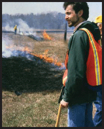
MnDOT controlled burns began in the ’90s,
prescribed burns by Caltrans burned in
2000 and FDOT began in March of 2005.
NOTE: Weather conditions will determine the day you execute the burn. Relative humidity between 25% and 60% is appropriate for a controlled burn.
Below 20% can be too dry and may become hazardous. Above 70% limits how much grass will burn. The lowest humidity of the day is usually between
3:00-5:00pm. High temperatures above 70 degrees Fahrenheit can increase the speed of the burn. Bright sun can increase the effect of the temperature.
A steady breeze of 3-15 mph is ideal for burning and carries fire in a definite direction. However wind gusts and direction changes can take a fire out
of control quickly. Further understanding of weather conditions will be part of the specific burn plan.
CHECKLIST:
- Define plan with partners
- Purchase equipment if needed
- Train crew (Fire Leader)
- Acquire permits
- Inform local fire department
- Inform the public before fire
- Handouts or kiosk pull-off
- Provide highway warnings
- Check weather forecast
- Be aware of wind changes
- Monitor and mop up
- Inform public about results
References Cited:
Caster, Jeff, 2009. Communication based on Environmental Excellence story, 2007. National Interagency prescribed Fire Training Center.
http://www.fws.gov/fire/pftc- content is no longer available
National Interagency ESA, 2002. Fire Ecology. Ecological Society of America. Washington D.C.
Hartwell, George 2009. Personal communication CALTRANS.
Pauly, Wayne R. 1982. How to Manage Small Prairie Fires. Dane County Park Commission, Madison, WI.
Rice, Peter M. 2005. Fire as a Tool for Controlling Nonnative Invasive Plants, A review of current literature. Center for Invasive Plant Management,
Bozeman, MT.
Tu, M., C. Hurd, and J. M. Randall, 2-001. The Nature Conservancy Weed Control Methods Handbook.
http://digitalcommons.usu.edu/cgi/viewcontent.cgi?article=1532&context=govdocs.
US Forest Service, http://https://www.fs.fed.us/
Back to top
CHAPTER 5
FOUR MODERN PARTNERSHIPS
1. COOPERATIVE WEED MANAGEMENT AREAS:
- On the ground partners.
- Sharing resources.
- Improving Public Relations.
- Saving Costs.
- Supporting EO 13112.
- MOU EXAMPLES: Pages 206-212.
The Cooperative Weed Management Area CWMA Cookbook was published in 2003, but had been in the works for a long time. The recognition that invasive plants
don’t respect political boundaries logically led to a joint control response by public and private landowners.
The rapidly rising costs of control were unacceptable as the spread of weeds escalated. In many regions, partnerships were being formed among unlikely
partners including State Departments of Transportation, Federal Lands, Agriculture, Fish and Game, and federal agencies including the Forest Service,
National Park Service, and the Natural Resource Conservation Service. The University of Idaho, The Nature Conservancy, and Nez Perce Tribe were among
the many partners in the first CWMA.
To learn more, workshops are available across the Country. Some of the steps to organizing a CWMA are in the checklist below. Use this model to find a
solution for your own region with your own partners. When weeds cross borders, managers must cross borders too.
CHECKLIST:
- Choose a leader
- Determine common goals
- Invite likely partners
- Develop an agreement
- Create a management plan
- Agree on an annual operating plan
- Establish a steering committee
- Continue communication
References Cited:
Greater Yellowstone Weed Committee, 2009. http://http://www.fedgycc.org/
Idaho Noxious Weed Coordinating Committee, 2003. CWMA Cookbook, A Recipe for Success. Idaho State Department of Agriculture, Boise.
New York State DOT, 2004. Adirondack Park Invasive Plant Program MOU http://www.adkinvasives.com
Van Devender, Thomas R., et al. 2009. Invasive Plants on the Move, Controlling Them in North America (Weeds Across Borders proceedings). Arizona
Sonora Desert Museum, Tucson.
2. THE GREATER YELLOWSTONE AREA
The Greater Yellowstone Area (GYA) is likely the largest and oldest cross-boundary management partnership today. Their cooperation has expanded since
a 1964 Memorandum of Understanding (MOU). The spread of invasive species now threatens the overall management of this national park that crosses many
political boundaries, including three State borders
Invasive weeds do not respect these boundaries, which further complicates management.
This public-private and multi-agency partnership has focused on weed control and reviews their joint plan annually. Because of this unprecedented cooperation,
the Greater Yellowstone Area is geographically contiguous, ecologically interdependent, and unalterably linked economically. It is a national model for
partnerships without political boundaries.
3. INTERAGENCY, INDIAN NATION and INTERNATIONAL MOUs
When a common problem is found on common ground, a partnership MOU can be part of the answer. Invite all stakeholders to the table to agree on the shared
problems. This necessitates frank discussions of the issues and possible solutions. These three MOU examples are included in the Appendix of this handbook.
- Adirondack Park/NYSDOT/ANC/DEC/and IPC (2004),
- Fond du Lac Band of Lake Superior Chippewa/MnDOT (2009),
- Okanogan County/WashDOT/British Columbia(2007).
These examples demonstrate new frontiers of State DOT cooperation, motivated by a need to control weeds across political boundaries: national parkland,
international border, and Indian Nation lands.
The language and layout is different in each, of course. The variables of regions within the U.S. are visible in the New York, Washington and Minnesota
MOUs. However their similarities and needs for cooperative vegetation management can guide your own MOU partnership. As with all agency documents, keep
it as simple as possible. Be sure the public hears about your partnership. Here is a basic outline.

Commissioner Tom Sorel and Chairwoman Karen Diver signing an unprecedented
Fond du Lac/MnDOT MOU, 2009.
MEMORANDUM OF UNDERSTANDING OUTLINE
- Principal Parties.
- Shared Problem and Purpose.
- Goals and Objectives.
- Responsibilities of each Signee.
- Signatures of Parties.
BENEFITS:
- Limit the spread of invasive plants across political boundaries.
- Share the costs of control during times of limited resources.
- Protect significant plants and resources on all lands.
- Develop public awareness and support for weed control.
- Increase understanding of each other’s constraints and policies.
NOTE:
The New York, Washington and Minnesota MOUs are found on pages 224-231.
4. OUTDOOR ADVERTISING AND FLORIDA
Jeff Caster, Florida DOT
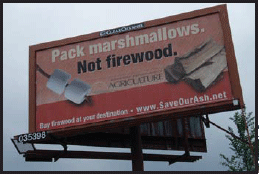
An outdoor advertising sign in Minnesota warning
of the invasive emerald ash borer.
In Florida, with more outdoor advertising signs than any other state, sign owners or their agents may apply to the Department of Transportation for permits
to manage vegetation on the state highway system. Permits are issued to preserve or increase the visibility of outdoor advertising signs located on nearby
properties. Persons and parties opposed to this activity find it inconsistent with Article II, section 7(a) of Florida Constitution which states, “It
shall be the policy of the state to conserve and protect its natural resources and scenic beauty.” Nevertheless, the department’s authority to issue
permits, and the sign owner’s limited right to maintain visibility of his/her signs, is codified in Section 479.106, Florida Statues.
Within the law, the department is given authority to establish a permitting process, a mitigation program, and penalties for violations. A disincentive
discourages the placement of new signs at locations where cutting, trimming, or removal of existing vegetation from the state highway system is needed
to make the new sign visible.
Sign owners desiring to cut, trim, or remove vegetation from the right of way, submit an application and a vegetation management plan, accompanied by
a nominal application fee. The vegetation management plan must be prepared by a landscape architect or certified arborist. Department staff responsible
for reviewing plans have similar qualifications. After thorough review of proposed plans, the department may approve, approve with conditions, or deny
the application.
Applications can be denied for a variety of environmental and safety reasons. When and where appropriate, a mitigation plan or mitigation fee is also
required. Mitigation values are determined using a formula developed by the department. The mitigation values are high enough to deter unnecessary cutting,
trimming and removal. Penalties for unauthorized cutting, trimming and removal of vegetation on the state highway system can be substantial. Mitigation
and penalty fees support tree planting programs. Florida law prohibits planting trees and other vegetation that screens or will grow to screen an outdoor
advertising face. The limits of screening or limits of visibility are known as the view zone. Typically, the view zone is 500 feet long, somewhere within
the first 1000 feet measured from the sign.
The application form, instructions, and other useful information are found at www.MyFloridaBeautiful.com.
Back to top
PART 7
APPENDIX
Introduction
Thanks to the advances of the “information highway” there is no lack of references to help get things done. Most land managers need to make
decisions on a daily basis and sorting through new information and paper references of the past takes time. This section attempts to collect some of the
best known and most reliable information on vegetation management. We quickly learned how complex the subject really is.
In the world of federal, State and county agencies, we know the importance of abiding by legal requirements. There are also authorities that will help
you achieve your management goals. We include both in this section.
In recent years, NatureServe carried out a national scientific study to rank the 3000 or more invasive plants that exist in the United States. As managers,
we need to know which plants are the most problematic yet controllable in order to define targets for limited budgets. The I-Rank section describes Natureserve’s
work to this point.
We’ve gathered book and internet references and organizations that can impart specific knowledge about native and invasive plants along with regional
centers of information you can contact to learn more. We further explain how to order publications that the Federal Highway Administration has available.
Finally we offer classroom and field exercises for use in annual training programs of agencies that work in land management. They include teaching ideas
that will lead to group discussions and learning applications for each part of this manual. Always teach with open ears and take advantage of opportunities
to solve problems on the ground.
Back to top
CHAPTER 1
CLASSROOM AND FIELD EXCERCISES FOR INSTRUCTOR USE
READING AN ECOREGION MAP: (Part 1 and 2)
Setup: Your State’s ecoregions can give you clues to vegetation management and planning. Give each student a copy of their State’s map
(in color).
Directions: Ask students to locate where they live on the ecoregion map and describe that ecoregion. Locate the meeting site and describe.
Discussion: When they leave for work in the morning, do they see vegetation typical of their ecoregion? If not, why not?
Discuss the meeting site in detail: What is its ecoregion? What vegetation is prevalent? What native grasses, forbs, trees and shrubs
grow there? They can list separately or in teams as a competition.
NATIVE AND INVASIVE PLANT IDENTIFICATION: (Part 4 and 5)
Directions: Ask students to pick “wildflowers” from a roadside chosen for safety by the instructor ahead of class. Do not define wildflowers.
But do remind them to stay safe (explained by instructor per State policy) in the process. This can be done in an overnight class or lunch hour class.
Exercise: Gather around a table or sit on the floor and ID each plant, one by one, placing them in one of two piles. The instructor can
put natives in one pile and invasives in a second stack without saying why.
Discussion: Why are there more plants in one pile than the other? Explain which is native and which is nonnative.
- Normally there will be more invasives than natives due to our planting and maintenance practices (more disturbances, State planted them, other).
- If there are more natives, discuss why (only County roadsides were picked, or your manager is planting more natives, etc.).
- Discuss why their findings are important to vegetation management planning.
- What can they do in their own District?
SELECTING A SEED MIX: (Part 4)
Directions: Suggest one or more project locations for this exercise (roadside in front of meeting, the Interstate they took to the meeting,
a nearby rest area etc.). Ask each student to jot down the site description including: type of soil, moisture conditions, and sun aspect of the site.
Find it on your State ecoregion map.
Exercise: Supply list of native grasses in your region (list Sources include your DNR, your TNC, or Roadside Use of Native Plants) and
discuss characteristics of each (about 10) including mature height, site tolerances, availability, source and costs. Direct each student to jot down a
minimum of 3 grasses they could use on their site. Be sure they know if their site is dry, mesic, wet, or a combination.
Discussion: Each participant should hand in their project list. Correct any selections that are clearly not practical, and carefully
explain why. Then, for open discussion, talk about the following steps to implement:
- Site preparation (weed removal, limited disturbance, etc.).
- Seeding rate (15-20 lbs/acre or less).
- Seeding source (availability and cost per acre).
- Planting method (drill, broadcast, hydro seed).
- Follow-up (water in dry year, mowing of first weed competition, monitor for new weeds, tell the public including your family what you are trying to do).
The instructor should mention any non native grass on the site and discuss how it got there. Why is their new list better for the project?
HOW TO READ A WILDFLOWER SEED MIX LABEL: (Part 4)
Setup: Wildflower seed that is available is not always what will work best for a highway project. Vegetation managers need to know what
to look for on a seed mix label to understand if they are getting their money’s worth and if the mix is likely to succeed on the site they have chosen.
A sample Wildflower Seed Mix Label should be provided to participants.
Directions: Ask students to examine the label. Begin by asking them to answer these three questions:
- Will these wildflower species grow in my district?
- Which flowers are not appropriate? Each region will have different answers.
- Where was this seed grown?
Discussion: Discuss answers and related details like cost and availability. Might it be better to plant native grasses only?
FIELD TRIP TO STATE PRESERVE/SEED MIX: (Part 4)
Directions: Locate a TNC Preserve (http://my.nature.org/preserves/) or State Scientific
and Natural area near the classroom. Visit it and learn about its history of land use, its plants, soils and moisture, wildlife that lives there, etc.
Before class, secure the plant inventory list to hand out.
Exercise: Give each student the inventory list to use as a check list of what they actually see and identify independently or as competitive
teams. Explain as much as you can about the land use history of the site and why it is important. After hiking and identification, ask each student to
take a blank piece of paper and describe in words and/or sketches what they will remember about this place. Have them sign and hand in their impressions.
Classroom Discussion:
- Select and read notes gathered from the field to review their experience.
- Pop quiz - give them a hypothetical new road through a map of the preserve. Discuss project objectives. Ask them to pull out their plant inventory lists
from the preserve and circle 10-20 plant species (grasses and forbs) they could plant on the roadside project. Ask them to sign and hand in their “seed
mix” lists. Openly discuss what might work and what would not.
INSTALL A NATIVE WILDFLOWER GARDEN IN 30 DAYS: (Part 4)
In 1996, Secretary of Transportation, Rodney Slater asked that we honor his visit to Mrs. Lyndon Johnson. We determined, with the help of the Texas DOT,
that adding a monument to an existing wayside near the Johnson Ranch would be the answer. We then asked the Texas DOT to design a garden as context to
the monument. In thirty days, the District Office designed the garden, found native plant materials, and installed it. The author visited the wayside
on the day before the dedication.
The crews were tidying the site with a last minute mowing, when a limousine pulled up. The back window opened and Mrs. Johnson engaged the crew with her
praise and thank yous for their hard work. What a moment.
Typically crews do not garner this kind of appreciation. What if a request for a native wildflower garden hit your office? What if you had 30 days, to
find an appropriate site, design the garden, acquire the plants, etc? What would you do?
Exercise: Ask each student to write their solution on one page.
Classroom Discussion:
- Site selection.
- Garden design....who does it.
- Do you need help…where would you get it? (central office, consultant, garden center, local grower)?
- Where will you get the plants and/or seed?
- Who will stake the plant locations, plant them water and maintain?
- Is it doable?
- What are the challenges in your State?
RIGHTS-OF-WAY, HOMES TO INVASIVES: (Part 5)
Setup: Highway rights-of-way (ROW), rail corridors, and utility rights-of-way are maintained for different purposes in different ways.
But these linear strips often share common fencelines and invasions of common weeds. Weeds do not respect those fencelines. How might we work with utilities
and railroads? It begins with identifying our common weed species.
Directions: Chose a site of about an acre in size that will best illustrate the invasive problem (with adjacent ROW, if possible). Be
sure it is accessible and students have vests and hard hats available. Or provide each a photograph that can be examined. Ask each student to write down
the names of all invasive plants visible in the photo. Have them underscore each plant that is also on their State Noxious Weed list.
Class Discussion: Discuss their findings. How did each plant get to that site? (Consider topsoil, construction, seed mix, adjacent land
owners, mowing or other maintenance practice, etc.) How might you work with neighboring lands, especially corridors?
GET TO KNOW YOUR STATE NOXIOUS WEED LIST: (Part 5)
Directions: Read the hand-out, your State Noxious Weed List, and answer the following:
- How many plant species are on your list?
- Which State agency (agriculture or natural resources) has authority?
- Does the DOT plant any species on the list?
- Which plants on the list does your District control?
- What plant(s) do you think should be added and how would you do it?
Exercise: Students can report their short list. Have each nominate a plant they think should be added to the list.
Discussion: Answer the following questions.
- Which nominations are native and which are nonnative to your State?
- Does your State include native species in its list? Most do not.
- Discuss which is the biggest problem to roadsides, to agriculture, and to the environment.
- Vote on the biggest problem weed in your State that should be added to the list.
HOW TO CONTROL A NOXIOUS WEED: (Part 6)
Setup: Chose a weed species that students are familiar with in your region,and that is include-d in the list of this book, part 6.
Directions: Ask students to look up the suggested controls in this book. Then ask, “If your State legislated a moratorium on herbicide
use tomorrow, what tools would you use to prevent further spread of that weed.”
Class Discussion: You are likely to get different answers depending on students’ experiences. Talk about the pros and cons of each and
consider a vote at the end to decide a reasonable strategy. Consider costs, timing, other vegetation in the area, etc. Ask if they would consider sharing
resources. If so, how would they do it?
ROADSIDES FOR WILDLIFE: (Part 5)
Setup: States like Utah, Minnesota, and North Carolina have Roadsides for Wildlife Programs. Hunting and fishing are economic benefits
in most States.
Directions: Ask students to form two lines (one of fishers and hunters, another of people who do not hunt and fish).
Debate: Why or why not have a Roadsides for Wildlife Program in highway corridors. Ask the fishers and hunters to be against the program
and give their reasons. Ask people who do not hunt and fish why it is important to have such a program. Hopefully you find that there is common ground
among them all.
REDUCED MOWING: (Part 6)
Setup: Reduced mowing has many conservation benefits as well as economic and environmental improvements. How can less work have so many
good consequences? Ask students to orally list all the benefits such as wildlife habitat, cost savings, and reduced vehicle emissions.
Directions: Chose a site that all attendees know: their own district yard, the roadside at meeting location, a State park, etc. Ask each
to describe what will happen in 3, 5, and 10 years at that site if it were left to nature.
Class Discussion: Recruit answers and try to narrow down the likely successional result of reduced mowing. Can they live with that result?
For how long?
PARTNERSHIPS: LOCAL, STATEWIDE, REGIONAL, INTERNATIONAL: (Part 6)
Setup: Ask students (by a show of hands) if any of them are currently part of a partnership to control invasive plants or noxious weeds.
Describe the Malheaur County/BLM/ODOT partnership that shared resources and provided 10 times the amount of control. (Page 40 in Roadside Weed
Management.)
Directions: Ask students to read the Aidirondack Park MOU on page 224
Class Discussion: Lead the discussion using these basic questions:
- How would your District benefit by partnering with others? (less need for expensive equipment, save money, control more weeds, make friends, inspire others
to work together, etc.)
- What strengths/skills do your crews bring to a partnership?
- What would they be willing to share or do in a partnership?
Develop a short list to share with other participants.
THE IMPORTANCE OF THEIR WORK: (Part 6)
Setup: The life of a vegetation manager is complex. There are regulations about water quality, native wildflowers, beautification, erosion
control, endangered species, noxious weeds, migratory birds and more that constrain what they can do. The rights-of-way are filled with safety, directional,
and information signs and structures that become an obstacle course. the roadside is a darn dangerous place to walk or drive with the traveling public
whizzing by! The work you do is hard work and important work.
Directions: Write three short paragraphs about how you would describe your job to your family, or to your Governor, or to a newspaper
reporter. Stress how difficult their job is AND how difficult it is to explain it. No names needed on this one.
Class Discussion: Collect all writings and randomly chose some to read aloud. (Do not judge what you are reading.) Ask them to discuss
their reactions. Direct conversations about: working for the government, family perceptions, daily difficulties on the road, pride in their work, support
from their families and the public, etc. In the end, stress the VALUE of their work to their community, their family, the State, and the Country. Yes,
this is a thoughtful pep talk; but everyone needs to know how to explain what they do for the good of transportation and the people who use it. Keep it
positive.
ROADSIDE ETHIC: (Part 6)
Setup: Some of the public think that transportation workers do not care about the environment, and have no commitment to conservation.
Perhaps a discussion among your class will provoke thought on this issue.
- Roadsides constitute the front yard of every community and because of this, if for no other reason, they should be developed and maintained in a manner
befitting such a distinction. (Bennett, 1936)
- Protecting the utility, beauty, and intrinsic value of our roadside biota remains our responsibility. It’s the only management decision that makes
sense. (Callicot and Lore, 1999)
- The earth’s vegetation is part of a web of life in which there are intimate and essential relations ships...Sometimes we have no choice but to disturb
these relationships, but we should do so thoughtfully, with full awareness that what we do may have consequences remote in time and place. (Carson,
1962)
Directions: Ask students to read these three quotations and then write a paragraph about how they view their own personal responsibility
to environmental stewardship.
Class Discussion: Randomly chose answers and read aloud. Ask the group to comment.
Back to top
CHAPTER 2
ADDITIONAL READING AND RESOURCES
NATIVE PLANT INFORMATION
NATIVE PLANT REFERENCES: Brooklyln Botanic Garden Record, 1989. Gardening With Wildflowers & Native Plants. Brooklyn Botanic
Garden, New York.
Diekelmann & Robert Schuster, 2002. Natural Landscaping, Designing with Native Plant Communities. University of Wisconsin Press, Madison.
Dupont, Elizabeth N. 1978. Landscaping with Native Plants in the Middle Atlantic Region. The Brandywine Conservancy, Chadds Ford, Pennsylvania.
Harper-Lore, B.; M. Wilson, Eds. 2000. Roadside Use of Native Plants, U.S. DOT, FHWA. ISBN: 1-55963-837-0. Hard copies available from Island Press, Electronic
copy is on-line at https://www.environment.fhwa.dot.gov/env_topics/ecosystems/roadside_use/roadside_toc.aspx
Hunter, Margie, 2002. Gardening with the Native Plants of Tennessee. The University of Tennessee Press, Knoxville.
Miller, George O. 1990. Landscaping with Native Plants of Texas and the Southwest. Voyageur press, Stillwater, Minnesota.
Miller, William H. W., 1984. Landscaping with Wildflowers & Native Plants. Chevron Chemical Company, San Francisco.
Nelson, Gil, 2003. Florida’s Best Native Landscape Plants. University Press of Florida, Gainsville.
Pettinger, April and Brenda Costanzo, 1996. Native Plants in the Coastal Garden. Timber Press, Portland, Oregon.
Wasowski, Sally with Andy Wasowski, 1994. Gardening with Native Plants of the South. Taylor Publishing Company, Dallas, Texas.
NATIVE PLANT WEBSITES
www.mobot.org is the long-recognized home of the Center for Plant Conservation. Packed with information for homeowners
and land managers, the site offers a State contacts Directory.
www.natareas.org is the home of the Natural Areas Association, an international nonprofit with a mission to preserve
natural diversity. Lots of land management information.
www.natureserve.org is the website of Nature Serve Explorer, an online encyclopedia for 50,000 plants and ecological
communities of the United States and Canada. With the common or scientific name of a plant, you can learn its life history, distribution map, and more.
www.nps.gov/ is the federal interagency Plant Conservation Alliance that began in 1994 with the purpose
of sharing information and resources on behalf of native plants.
www.wildflower.org is the website of the Lady Bird Johnson Wildflower Center which educates about the environmental
necessity, economic value, and natural beauty of wildflowers and native plants across America.
INVASIVE PLANT INFORMATION
INVASIVE PLANT REFERENCES: Bossard, Carla C., John M. Randall, and Marc C. Hosbovsky, 2000. Invasive Plants of California’s Wildlands.
University of California Press, Berkely and Los Angeles.
Britton, Kerry O., Ed., 1997. Exotic Pests of Eastern Forests. USDA Forest Service and the Tennessee Exotic Pest Plant Council.
Czarapata, Elizabeth J., 2005. Invasive Plants of the Upper Midwest. University of Wisconsin Press, Madison.
Randall, John M. and Janet Marinelli, Editors, 1996. Invasive Plants, Weeds of the Global Garden. Brooklyn Botanic Garden, NY.
Taylor, Ronald J., 1990. Northwest Weeds, the Ugly and Beautiful Villains of Fields, Gardens, and Roadsides. Mountain Press publishing, Missoula,
Montana.
Tellman, Barbara, Ed., 2002. Invasive Exotic Species in the Sonoran Region. University of Arizona Press and Arizona-Sonora Desert Museum, Tucson.
Tu, M., Hurd, C. and J.M. Randall, 2001. Weed Control Methods Handbook. The Nature Conservancy, www.tncweeds.ucdavis.edu.
Uva, Richard H., Joseph C. Neal, and Joseph M. DiTomaso, 1997. Weeds of the Northeast. Cornell University Press, Ithaca, New York.
Westbrooks, R. 1998, Invasive Plants, Changing the Landscape of America, a handbook. Federal Interagency Committee for the Management of Noxious
and Exotic Weeds (FICMNEW), Washington D.C.
Whitson, Tom D., et al. 1992. Weeds of the West. University of Wyoming, Jackson.
INVASIVE PLANT WEBSITES
www.plants.usda.gov maintains the National Plant Database Project.
www.nps.gov/ is the Weeds Gone Wild site of the Plant Conservation Alliance.
TNC.weeds@ucdavis.edu TNC’s Wildland Invasive Species Program offers decision-makers years of land management
experience regarding problem plants, control methods, a power point presentation you can use, a press release template, and ways to utilize volunteers.
REGIONAL CENTERS OF INVASIVE PLANT INFORMATION
http://plants.ifas.ufl.edu/ is the Center for Aquatic and Invasive Plants since 1979. The site
contains images and information for 383 native and non-native species found in Florida.
http://invader.dbs.umt.edu/ is the website of the INVADERS Database System from the University
of Montana contains the INVADERS Database System provided by the Agricultural research Service (ARS), USDA. Site includes U.S. and Canadian noxious weed
lists.
www.newfs.org the New England Wild Flower Society addresses plants in New England.
www.uni.edu/irvm is the Integrated Roadside Vegetation Management homepage from the new national
vegetation center at the University of Northern Iowa.
www.usgs.nau.edu/SWEPIC/swemp serves the southwest via the Southwest Exotic Plant Information Clearinghouse.
This site is filled with practical information.
www.weedcenter.org is home to an in-depth western weed clearinghouse of information. The information comes from
the
Center for Invasive Plant Management in Montana.
AVAILABLE FHWA/USDOT PUBLICATIONS
FAX request to warehouse at (301) 386-5394. Specify the publication number, quantity, and your shipping address.
FIELD GUIDE SERIES (LAMINATED GLOVE-COMPARTMENT SIZE):
- Common Roadside Invasives,
A roadside field guide to showy herbaceous weeds FHWA-EP-02-003
- Common Roadside Wildflowers,
A field guide to native forbs and grasses FHWA-EP-03-007
- Common Roadside Wildflowers, Western Edition
A roadside field guide for the Western Region FHWA-HEP-05-047
- Common Roadside Invasives,
A field guide to nonnative trees, shrubs, and vines. FHWA-HEP-07-021
- Common Aquatic Weeds,
A field guide to invasive aquatic plants found throughout the waters of the United States. FHWA-HEP-09-016 Harper-Lore, B.; M. Johnson; M. Skinner, Eds.
2007. Roadside Weed Management, U.S. DOT, FHWA. FHWA-HEP-07-017.
http://www.weedcenter.org/store/docs/books-brochures/roadside%20weed%20 management.pdf
INTEGRATED VEGETATION MANAGEMENT REFERENCES:
- Roadside Weed Management (FHWA, EPA,NRCS)
http://www.weedcenter.org/docs/books-brochures/roadside%20weed%20management.pdf
State by State reference of noxious weed laws, weed lists, and State resources. Includes a 65 page primer on invasive plant prevention, control, restoration,
education, and policy. FHWA-HEP-07-017
- The NATURE Of ROADSIDES, and the Tools to Work With It.
A 32 page training tool including best management practices, ecological principles and policies for land managers. FHWA-EP-03-005
- Roadside Use of Native Plants (FHWA)
A State by State reference with trees, shrubs, vines, grasses, and forbs that are native in each, along with State resources for guidance in restoration,
revegetation, erosion control, and landscaping uses. A 47 page primer by native plant experts and practitioners is useful in training. The appendices
include roadside policies, references, and plant community lists. For use by all land managers. Out of print. Reprinted by Island Press and can be ordered
through book sellers. Electronic copy is on-line at https://www.environment.fhwa.dot.gov/env_topics/ecosystems/roadside_use/roadside_toc.aspx
- Native Alternatives to Invasive Plants (FHWA and BBG)
Recommended native plant alternatives for each major invasive plant in the United States, many of them ornamental plants. Written by Cole Burrell and
edited by FHWA and the Brooklyn Botanic Gardens in 2006. Available through the BBG in quantities or at local book stores.
Back to top
CHAPTER 3
MOU EXAMPLES
ADIRONDACK PARK INVASIVE PLANT PROGRAM MOU
This Memorandum of Understanding is entered into this 8th day of April 2004, by the NEW YORK STATE ADIRONDACK PARK AGENCY (hereinafter referred to as
“APA”) having offices at Box 99, Ray Brook, New York, 12977, the NEW YORK STATE DEPARTMENT OF TRANSPORTATION, REGIONS 1, 2 and 7 (hereinafter
referred to as “DOT”), having offices in Schenectady, Watertown and Utica, New York, the NEW YORK STATE DEPARTMENT OF ENVIRONMENTAL CONSERVATION,
REGIONS 5 and 6 (hereinafter referred to as “DEC”) having offices in Ray Brook and Watertown, New York, the INVASIVE PLANT COUNCIL OF NEW
YORK STATE (hereinafter referred to as the “IPC”) having offices in Troy, New York, and THE ADIRONDACK NATURE CONSERVANCY (hereinafter referred
to as “ANC”) a not-for-profit corporation organized and existing under the laws of the District of Columbia, having its principal office at
1815 North Lynn Street, Arlington, Virginia, 22209, authorized to conduct business in the State of New York as The Nature Conservancy, Inc., acting by
and through its Adirondack Operating Unit.
WHEREAS, the NYS Adirondack Park, a six million acre region of public and private land, is a unique natural region. It is the largest wilderness area
east of the Mississippi River, and forms the headwaters of five major rivers. With large unfragmented tracts of forested land, the Park is a virtual island
in the highly populated Northeast. Deciduous and coniferous forests are interspersed with lakes, rivers, wetlands, and other natural communities; and,
WHEREAS, invasive species have significant environmental, social, and economic impacts on natural areas. They can negatively impact ecosystems through
competition, suppression, and displacement of native species and through the alternation of ecosystem functions such as nutrient cycling and hydrology.
For the purpose of this agreement, invasive plant species are defined as those found outside of their normal range and, due to certain characteristics,
are able to move into an area and become dominant numerically, in cover, resource use, or other ecological impact. It is important to recognize that
most non-native plants (i.e. species that have established or been introduced to an an area where they do not naturally occur) are not invasive; and,
EDITOR’s NOTE: Seventeen (17) more whereas follow defining the extent of the problem and the partnership’s responsibilities to protect the natural resources
of the region, and explaining how together the various agencies can accomplish more cooperatively.
NOW THEREFORE, in consideration of the mutual agreements set forth herein, APA, DEC, DOT, IPC and ANC agree to act cooperatively in the implementation
of an Adirondack park Invasive Plant Program (hereinafter referred to as “APIPP”), as follows:
1. ADIRONDACK PARK INVASIVE PLANT PROGRAM.
- Monitoring and inventory:
- Invasive species autecology and control methods:
- Implementation of control methods:
- Monitoring to determine success:
- Education and outreach:
- Funding:
- Information exchange:
- Management: Designate an official “Adirondack Park Weed Management Area” to advance the recognition of invasive plant issues among stakeholders,
local, state, and federal governments and to facilitate cooperative approaches for invasive plant management.
2. RESPONSIBILITIES OF THE SIGNEES. Editor’s Note: each signee’s responsibilities are then spelled out.
New York State Department of Transportation
- Conduct control activities within Interstate and state highway rights of way (ROW);
- With the appropriate releases conduct control activities on private lands adjacent to the Department’s ROW;
- Collect requested data regarding location, species and control methods;
- Develop guidance, specifications, training materials and best management practices (BMP’s) that reduce or eliminate the introduction and spread of invasive
species within the ROW;
- Utilize species location information for BMP’s when designing, construction, and maintaining Interstate and state highway systems within the Park;
- Seek continued Federal funding for research on invasive plant management issues;
- Develop a written annual work schedule committing to invasive plant species management within the ROW in the Park at the annual late Winter Partners’
meeting;
- Provide status reports regarding “g” above at the annual Summer and early Winter partners’ meetings;
- Provide invasive plant species awareness and management training to appropriate State Department of Transportation staff;
- Identify invasive plant biomass disposal and transfer areas at local residencies and other Department controlled facilities;
- Coordinate with local municipal maintenance and transportation departments on highway BMPs that would be implemented on non-State highways and roads;
- Assist maintenance of Terrestrial Invasive Plant Project database; document new infestations, document management controls implemented on existing infestations;
and produce maps for APIPP website and participants.
3. COMMUNICATIONS. The parties agree to share and coordinate all information regarding their respective activities in support of the Adirondack Park Invasive
Plant Program. To that end, all communication shall be directed to: (All signees’ addresses and phone numbers follow.)
4. TERM. April 2004-2008
EDITOR’s NOTE: For the complete MOU and other details, contact Hilary Oles. For more details about BMPs and cooperation by the New York State DOT, contact
Kyle Williams, (518) 457-5566.
FOND DU LAC/MNDOT MOU
The state of Minnesota through its Department of Transportation and the Fond du Lac Band of Lake Superior Chippewa do hereby commit to work cooperatively
together to manage the vegetation within the rights of way of state, U.S. and interstate roads located within the boundaries of the Fond du Lac Reservation,
thus honoring FDL’s control of the use of herbicides within their Reservation.
SUBJECT: Vegetation management along Minnesota Department of Transportation (hereinafter “Mn/DOT”) roads through the Fond du Lac Band
of Lake Superior Chippewa Reservation (hereinafter “FDL”).
PROBLEM: Mn/DOT uses a combination of mechanical, biological and chemical techniques to control weeds and maintain vegetation on state, U.S. and interstate
road rights of way throughout the state of Minnesota. FDL has expressed concern over the use of herbicides on the rights of way within its Reservation
boundaries and the loss of culturally significant plants and plant habitat. Mn/DOT has responded to this concern by not applying herbicides within
the Reservation boundary. New populations of invasive weeds have been found within the Reservation boundary on Mn/DOT rights of way. For Mn/DOT,
the most efficient and cost-effective treatment of these small populations is herbicide treatment. Another issue with the rights of way is the encroachment
of woody plants into the clear zone of the road and limiting drivers’ reaction time to wildlife crossing the road. To keep woody plants from encroaching
on the road, mowing must be performed several times during the growing season. This is less effective than one herbicide application, which lasts two
to three years.
SCOPE: The areas of concern are state Highway 210 from reference post 203.329 to 215.674, U.S. Highway 2 from reference post 231.744 to 239.034 and Interstate
35 from reference post 235.479 to 236.722.
PURPOSE OF THE MOU: This MOU is not a legal contract. Its purpose is to define goals and agreements between Mn/DOT and FDL in regards to control of
vegetation along Highways 2, 210 and I-35 within Reservation boundaries.
GOALS AND OBJECTIVES:
FDL GOALS
- Preserve heritage opportunities for gathering and harvesting culturally significant plants on the adjacent to Mn/DOT’s rights of way.
- Limit the spread of invasive plants within Reservation boundaries through use of Early Detection Rapid Response.
- Monitor land within Reservation boundary for potentially invasive species.
- Protect culturally significant plants and resources.
- Limit amount of herbicide used within Reservation boundaries.
- Restrict use of soil sterilants and restricted use herbicides.
- Develop educational opportunities and public awareness for community.
MN/DOT GOALS
- Provide a safe driving experience for all highway users by maintaining safety clear zones, sight lines and guardrails.
- Limit the spread of invasive plants on Mn/DOT roadsides through use of Early Detection Rapid Response and through the most efficient and cost-effective
method.
- Control woody plants encroaching on clear zones of roads through use of the most efficient and cost-effective method.
- Effectively control weeds and woody plants around radio towers.
- Develop educational opportunities and public awareness for the community.
UNDERSTANDINGS, AGREEMENTS, SUPPORT AND RESOURCE NEEDS: FDL AGREEMENTS
- For protection purposes, share spatial information on culturally significant areas.
- Contact members with information about the location and timing of herbicide application.
- Share spatial information on wetlands and water bodies within the Reservation.
- Partner with Mn/DOT to re-evaluate the site of herbicide application after application.
- Partner with Mn/DOT to mechanically remove invasive plants in areas where the FDL does not want herbicides used.
- Notify Mn/DOT of invasive plant populations found by FDL personnel that are on Mn/DOT rights of way.
MN/lDOT AGREEMENTS
- Provide FDL Resource Management Division with list of herbicide labels and material safety data sheets commonly used.
- Provide map and coordinates of known locations of invasive plants within the Reservation to FDL Resource Management Division.
- All herbicide applications for road purposes within Reservation boundaries will be performed by a Mn/DOT employee who is a Minnesota Department of
Agriculture Licensed Applicator in categories A and J.
- Apply for a Wetland Permit from FDL to comply with FDL Wetland Protection and Management Ordinance for any herbicide application that has the potential
to reach a wetland or body of water within Reservation boundaries.
- Contact FDL Resource Management Division 20 working days prior to applying any herbicide within Reservation boundaries and provide herbicide name, target
plant and location.
- Partner with FDL to Re-evaluate the site of herbicide application after application.
- Provide FDL with copy of Pesticide Application Log after spraying.
- Partner with FDL to mechanically remove invasive plants in areas where the FDL does not want herbicides used.
- Continue to map invasive plant populations on Mn/DOT rights of way.
CONTRACTUAL OBLIGATIONS: This MOU is not a binding contract between Mn/DOT and FDL. Either party may, upon written notice, amend or discontinue its
role outlined in the MOU. Because of this mutual desire to proceed, each party fully intends to make a good faith effort to achieve the goals described
above including working together to find mutually beneficial solutions when problems arise. This MOU shall become effective on the date of the last signature
and shall continue through January 2010 at which time the results of MOU will be reviewed by both Mn/DOT and FDL.
THIS MEMORANDUM OF UNDERSTANDING IS HEREBY AGREED TO
BY: Minnesota Department of Transportation
Fond du Lac Band of Lake Superior Chippewa
/S/ Thomas K. Sorel 5/15/09 /S/ Karen R. Diver 5/15/09
Thomas K. Sorel
Commissioner
Date
Karen R. Diver
Chairwoman
Date
CROSS BORDERS COOPERATIVE WEED MANAGEMENT MOU
PRINCIPAL PARTIES:
THIS MEMORANDUM OF UNDERSTANDING (MOU) IS MADE AND ENTERED INTO BY:
Okanogan County Noxious Weed Control Board, South Okanagan-Similkameen Invasive Plant Society (SOSIPS), British Columbia Ministry of Transportation, Boundary
Weed Management Committee (BWMC), Washington State Department of Transportation, Ferry County Noxious Weed Board.
PURPOSE:
The Parties listed above have weed management interests or responsibilities. Uncontrolled weed populations in one jurisdiction affect the ability of other
land managers/operators to control weeds on lands they administer. The Parties desire to come together to promote an integrated and coordinated approach
to weed management and vegetation improvement through information exchange, education and training, coordination of inventory and control, and sharing
of resources when appropriate.
COOPERATIVE WEED MANAGEMENT AREA to prevent and control plant species classified as noxious weeds that have an adverse effect on native plant communities,
wildlife habitat, crop yields on agricultural lands, livestock and grazing, to address weeds crossing borders on lands managed by all parties Comply with
the requirements of state law (R.C.W. 17.10). Promote the interest of all parties in an integrated approach to the management of noxious weeds. In order
to cooperatively promote the management of noxious weeds, protect the natural resources and the environment, all parties mutually agree to the following:
MUTUAL BENEFIT:
This MOU will provide a coordinated approach to weed and vegetation management issues. Coordinating management measures, sharing of knowledge, and in
some cases resources, will achieve better management of weeds and vegetation while improving working relationships among the partners and the public in
the US and Canada.
ORGANIZATION:
The activities of the Cross Borders Cooperative Weed Management Area shall be directed by a Working Group comprised of representatives of the Parties
to this MOU, with recommendations and suggestions from any interested landowner/operator. Consensus shall be the method of operation. Meetings shall
be conducted at least twice a year. A chair and vice-chair will be selected from the representatives.
DUTIES OF THE WORKING GROUP:
- Develop and maintain criteria for prioritizing species to be managed within the project area.
- Develop and maintain weed inventory.
- Develop or refer to long term weed management plan.
- Develop and maintain a communication and education system for those involved in weed prevention and control in the Cross Borders Project.
- Develop an education/outreach program to effectively communicate weed management issues to the general public.
- Promote improvement of desirable vegetation to resist invasion of weedy species.
- Prepare an annual written report of the weed management area activities of all the parties involved.
- Identify and pursue continuing opportunities for long-term funding of the weed management area programs described herein.
ADMINISTRATION:
- Nothing in this MOU will be construed as affecting the authorities of the Parties or as binding upon their respective authorities or to require any of
the Parties to obligate or expend funds in excess of available funding levels.
- The $l25,000.00 funding level approved for this project will be held by Washington State Department of Transportation and disbursed upon approval of
WA ST DOT.
- The MOU does not obligate or exchange the funds, supplies, equipment or services of any of the Parties hereto.
- Any Party may propose changes to this MOU at any time during its term. Modifications to this MOU shall be made by mutual consent of the Parties hereto,
by issuance of written amendment signed and dated by all Parties, prior to any changes to the MOU.
- This MOU is undertaken to clarify the roles of the participants and to obtain cooperation among the parties. It is understood that participation is of
a completely voluntary nature and no enforcement of this agreement is intended. Parties to the annual management plan shall voluntarily adhere to the
priorities and areas agreed upon, but shall not be required to perform work beyond availability of funds.
- Any Party to this MOU may withdraw from the MOU upon thirty day (30) written notice, stating the reasons for withdrawal.
- Each Party shall defend, indemnify and hold harmless each of the other Principal Parties, their officers, employees and agents from any and all liability,
loss expense(including reasonable attorneys’ fees) or claims for injury or damages arising out of this MOU, but only in proportion to and to the extent
such liability, loss, expense, attorneys’ fees, or claims for injury or damages are caused by or result from the neglect or intentional acts or omissions
of the indemnifying Principal Parties, their officers, agents or employees.
- This MOU will become effective December 31, 2007, upon signature by all its Parties and unless terminated, will continue through December 31, 2009 at
which time will expire unless renewed
SPECIAL WEED BOARD RESPONSIBILITIES:
- The weed board agrees to coordinate the cross borders project.
- The Weed Board agrees to reimburse the work performed in Canada after record requirements have been submitted and approved.
- The Weed Board agrees to organize and provide a Weeds Cross Borders Legislative field tour August 2008/2009.
SPECIAL WASHINGTON STATE DEPARTMENT OF TRANSPORTATION RESPONSIBILITIES:
- DOT agrees to contribute $25,000.00 from US Federal Highway Administration for “Weeds Cross Borders Project”.
THIS MEMORANDUM OF UNDERSTANDING (MOU) IS MADE AND ENTERED INTO BY:
Okanogan County Noxious Weed Control Board, South Okanagan-Similkameen Invasive Plant Society (SOSIPS), British Columbia Ministry of Transportation, Boundary
Weed Management Committee (BWMC), Washington State Department of Transportation, Ferry County Noxious Weed Board.
PURPOSE:
The Parties listed above have weed management interests or responsibilities. Uncontrolled weed populations in one jurisdiction affect the ability of other
land managers/operators to control weeds on lands they administer. The Parties desire to come together to promote an integrated and coordinated approach
to weed management and vegetation improvement through information exchange, education and training, coordination of inventory and control, and sharing
of resources when appropriate.
COOPERATIVE WEED MANAGEMENT AREA to prevent and control plant species classified as noxious weeds that have an adverse effect on native plant communities,
wildlife habitat, crop yields on agricultural lands, livestock and grazing, to address weeds crossing borders on lands managed by all parties Comply with
the requirements of state law (R.C.W. 17.10). Promote the interest of all parties in an integrated approach to the management of noxious weeds. In order
to cooperatively promote the management of noxious weeds, protect the natural resources and the environment, all parties mutually agree to the following:
MUTUAL BENEFIT:
This MOU will provide a coordinated approach to weed and vegetation management issues. Coordinating management measures, sharing of knowledge, and in
some cases resources, will achieve better management of weeds and vegetation while improving working relationships among the partners and the public in
the US and Canada.
ORGANIZATION:
The activities of the Cross Borders Cooperative Weed Management Area shall be directed by a Working Group Compromised or representatives of the Parties
to this MOU, with recommendations and suggestions from any interested landowner/operator. Consensus shall be the method of operation. Meetings shall
be conducted at least twice a year. A chair and vice-chair will be selected from the representatives.
DUTIES OF THE WORKING GROUP:
- Develop and maintain criteria for prioritizing species to be managed within the project area.
- Develop and maintain weed inventory.
- Develop or refer to long term weed management plan.
- Develop and maintain a communication and education system for those involved in weed prevention and control in the Cross Borders Project.
- Develop an education/outreach program to effectively communicate weed management issues to the general public.
- Promote improvement of desirable vegetation to resist invasion of weedy species.
Back to top
CHAPTER 4
REQUIREMENTS THAT SUPPORT AN ECOLOGICAL APPROACH
Anadromous Fish Conservation Act (16 USC 757z-g: 79 Stat. 1125)
Authorizes Interior and Commerce to enter into cooperative agreements for conservation, development, and enhancement of anadromous fish, and to contribute
up to 50 percent as the Federal share of the cost.
Bald Eagle Protection Act of 1940 (16 USC 668-668d, 54 Stat.250)
Provides for protection of the bald and golden eagles by prohibiting the taking, possession and commerce of such birds. The 1978 amendment allows the
taking of golden eagle nests that interfere with resource development or recovery operations.
Clean Air Act (CAA) of 1972 (42 USC ss/7401 et seq)
Originally signed in 1963, this law and standards set the maximum acceptable levels of outdoor air pollution. The standards are to be met by monitored,
control technology. Federal agencies must conform with each State’s State Implementation Plan (SIP).
Clean Water Act (CWA), Section 401 (33 USC ss/1251 et seq)
Section 401 established a State Water Quality Certification program, Each State must certify compliance of Federal permits with these requirements in
mind. Specifically applies to discharge to wetlands or other waters under State jurisdiction.
CWA, Section 402
Section 402 requires the National Pollutant Discharge Elimination System (NPDES) program to regulate discharges from point sources to waters of the United
States.
CWA, Section 404
Aimed at restoring and maintaining the chemical, physical and biological integrity of the Nation’s waters. Primary authority rests with EPA and USACE
for wetlands. This section is important for wildlife protection purposes it required permits for dredged and fill materials.
Coastal Barrier Resources Act (COBRA)
COBRA aims to minimize loss of life, wasteful expenditures and damage to natural resources (including wildlife). Agencies must consult maps with coastal
barrier unit boundaries and then coordinate with the USFWS if a project crosses near or into a unit.
Coastal Zone Management Act (CZMA) of 1972 (16 USC 1456)
This is “the national policy to preserve, protect, develop, and where possible, to restore or enhance, the resources of the Nation’s coastal zone
for this and succeeding generations.” The NOAA provides Federal approvals for CZM plans and oversees implementation.
Congestion Mitigation and Air Quality (CMAQ) Improvement Program
This program is aimed at air emission reduction emissions. Each action or project plan to improve air quality is submitted to the MPO and State for evaluation
and approval. The project is then included in the Transportation Improvement Plan (TIP) and overseen by EPA.
Emergency Wetlands Resources Act of 19986 (16 USC 3901-3932)
The purpose of this Act is to promote wetlands conservation for the public benefit and to help fulfill international obligations in various migratory
bird treaties and conventions.
Endangered Species Act (ESA) (USC 136; 16 USC 460 et seq)
The ESA gives broad protection to species that are listed as threatened or endangered in the U.S. or elsewhere. Procedures are provided when actions might
jeopardize listed species. It prohibits “taking” (without a permit) listed animals and regulates habitat destruction.
ESA, Section 7(a)
The goal of section 7(a) is to protect ecosystems in which endangered species exist. The Act requires consultation with USFWS and the NOAA Fisheries Service.
Executive Order 13112:
Invasive Species Aimed at prevention and control of invasive species to minimize economic, ecological, and human health impacts. It called for NEPA analysis
inclusion, plant inventories, management plans, new technologies, and no federal fund use for known invasives.
Executive Order 11990: Protection of Wetlands, DOT Order 5660.1A
Requires avoidance of support of new construction in wetlands wherever there is a practical alternative. Also requires evaluation and mitigation of impacts.
Executive Order 11988: Floodplain Management
The intent is to avoid long and short-term impacts and restore or preserve ecological services of floodplains. Any construction requires assessment of
hazards and specific findings in final environmental document for significant encroachments.
Federal Land Policy and Management Act of 1976 (FLPMA) (43 USC Sec. 1701)
Under Section 102 of FLPMA, BLM will manage lands to protect scientific, scenic, historical and natural resources, where appropriate, and protect certain
lands in natural condition for wildlife habitats as well as human uses. It underscores BLM’s mission.
Federal Aid Highway Act - Economic, Social, and Environmental Effects (23 USC 109 (h), P.L. 89-574, 5(a), 14, 80 Stat. 767, 771; Dec. 31, 1970)
The statute aims to ensure all adverse effects are avoided through other agency and public involvement. A systematic interdisciplinary approach is required
as is consideration of alternative courses of action.
Fish and Wildlife Coordination Act (16 USC 661-667e; the Act of March 10, 1934; Ch. 55; 48 Stat. 401)
Authorizes Interior to provide assistance to and cooperate with Federal, State, and public or private agencies and organizations in the development and
protection of wildlife resources and habitat, and to accept donations of land and funds to further the purpose.
Land and Water Conservation Fund Act of 1965 (16 USC 460l-4-460l-11)
16 USC 4601 regulates recreation user fees and establishes a fund to subsidize State and Federal acquisition of land, water areas, and facilities to assure
access to outdoor recreation resources.
Marine Protection Research and Sanctuaries Act of 1972 (Public Law 92-532; October 23, 1972; 86 Stat. 1052 and 1061)
Regulation of dumping material into U.S. ocean waters. The EPA and USACE oversee the permitting process for disposal in marine waters or artificial reefs.
Magnuson-Stevens Fisher Conservation Act (26 USC 1801 et seq)
The Act governs how much of the Nation’s fish can be harvested. An amendment tied fisheries sustainability to habitat rebuilding. Section 305 (b) (2)
requires Federal agencies to consult with NOAA on possible adverse effects to Essential Fish Habitat.
Migratory Bird Conservation Act of 1929 (16 USC 715-715r)
A Migratory Bird Conservation Commission may approve areas to be acquired with related funds. Interior may work with local authorities, conduct investigations,
publish bird documents, and develop refuges. Harm to birds, nest and/or eggs is prohibited.
National Trails System Act (16 USC 1241-1249)
Provides outdoor recreation needs and encourages use through national scenic and historic trails. Local side or connecting trails are approved by NPS
and USFS, who administer the trail system.
National Environmental Policy Act (NEPA) of 1969 (42 USC 4321-4347)
NEPA encourages harmony between humans and their environment by preventing damage. A statement of environmental impacts for major Federal action is required,
and appropriate alternatives must be explored. Ecological information must be part of planning.
National Park Service Organic Act of 1916 (16 USC 1 2 3, and 4)
Establishes the National Park Service to promote and regulate parks to conserve scenery, natural and historic objects, including wildlife therein. The
NPS provides enjoyment of resources while protecting for future generations.
Noise Standards (23 USC 109(i), P.L. 91605, P.L. 93-87, 23 CFR 772)
Promulgates noise standards for highway traffic. Projects that significantly change alignment or increase lanes must: do noise impact analysis, determine
mitigation measures, and incorporate reasonable and feasible noise abatement to reduce impacts.
Partnerships for Wildlife Act (16 USC 3741-3744)
Established a Wildlife Conservation and Appreciation Fund to receive funds and donations from the National Fish and Wildlife Foundation and other sources
to assist fish and game agencies in conservation work.
Rivers and Harbors Act of 1899 (33 USC 403)
Designed to protect navigable waters in the U.S. Estuarine and marine habitats are also protected. All plans for construction, dumping, and/or dredging
must obtain a permit. USACE, U.S. Coast Guard, EPA, and State agencies have responsibility.
SAFTEA LU Section 6006.439
The 2005 Transportation Act made the control of noxious weeds and establishment of native plants part of a vegetation management list eligible for federal-aid
funding. This new eligibility allows maintenance and other units to compete for allocations.
Section 4 (f ) of the Transportation Act (49 USC 1563 (f ) - 23 CFR 771.135)
Section 4 (f ) requires preservation of publicly owned parklands, waterfowl and wildlife refuges, and significant historic sites. A specific finding requires
that selected alternatives avoid the protected areas, and that planning minimizes harm. Coordination done with DOI, USDA, Housing and Urban Development,
State and/or local agencies.
Solid Waste Disposal Act (42 USC 82)
Provides for recovery, recycling, and safe disposal of solid wastes. EPA administers the provisions of this Act, especially to protect terrestrial and
aquatic habitats and wildlife.
Wild and Scenic Rivers Act (16 USC 1271-1287)
Established a National Wild and Scenic Rivers System to protect river values. The Act contains procedures and limitations for control of lands in the
System and for disposition of lands and minerals under Federal ownership.
Wilderness Act of 1964 (16 USC 1131-1136)
Established the National Wilderness Preservation System to secure and preserve lands in their natural condition for the American people of present and
future generations and benefits of an enduring resource of wilderness.
Wildflowers, (23 USC 329(B) P.L. 100-17, 23 CFR 752)
This statute is meant to encourage the use of native wildflowers in highway landscaping. Any landscaping project undertaken in the Federal-aid highway
system must expend one-quarter of 1 percent of landscape funds to plant native wildflowers.
References Cited:
Brown, Janice W., 2006. Eco-Logical, and Ecosystem Approach to Developing Infrastructure Projects (Appendix D). USDOT, Et Al, Arlington, Virginia.
FHWA-HEP-06-011.
Back to top

