COLORADO DEPARTMENT OF TRANSPORTATION
Planning and Environmental Linkage Program
Program Description
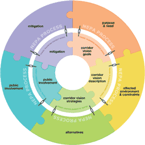
Graphic showing PEL planning components.
(Source: Colorado Department of Transportation.)
Program Benefits
- Colorado DOT’s (CDOT) “Planning and Environmental Linkages (PEL) Decision Tool” streamlines both project planning and delivery and establishes a proactive approach to addressing environmental and historic preservation issues.
- The Colorado State Historic Preservation Office’s involvement in the development of the program has contributed to building a better working relationship between the agencies.
- The program demonstrates CDOT’s commitment to identifying and considering historic preservation issues, and other environmental concerns early in the planning process.
The Colorado Department of Transportation (CDOT) has developed a new “Planning and Environmental Linkages (PEL) Decision Tool.” The purpose of this tool is to identify “red flags,” including problematic historic properties, during transportation planning. This tool can be used by anyone within the DOT and by local planning organizations that are provided access to the PEL tool through CDOT. The tool consists of a series of information and decision-making screens, including a screen on “Archaeological/Historical/Paleontological” resources. The final output using this tool is an environmental planning report.
Setting Up the Program
The PEL program was started by CDOT’s Division of Transportation Development managers, with support from the Planning Division and Information Technology (IT)/Geographic Information System (GIS) staff.
A vacant full-time-employee (FTE) position in the Planning Division was available and was used to create the PEL program coordinator’s position. The position was paid for out of State Planning and Research (SPR) funds. State funds were used to develop internal training programs and the PEL’s GIS screening tool.
Challenges Encountered
Program Elements
- Historic Preservation in Transportation Planning
- Historic Preservation in Early Project Development
- Interagency Cooperation and Collaboration
- Geographic Information Systems
- Historic Property Database
- Historic Property Screening Tool
- Historic Property “Red Flags”
One initial challenge was funding. Guidance included Appendix A of 23 CFR 450 (the Appendix dealt with linking the transportation planning and National Environmental Policy Act processes) was used, in part, to justify the creation of the PEL program. Also, CDOT already was committed to similar “big picture” planning efforts, such as conservation banking. The PEL program was promoted as one of these planning efforts.
Another challenge was difficulties in acquiring and housing critical environmental data. Two critical issues were deciding who should house and maintain the PEL database, CDOT or resource agencies, such as the State Historic Preservation Office (SHPO); and, who should have access to sensitive resource locational information stored within the database. PEL program staff is still working out the solutions to these issues.
The biggest challenge to date relates to different perspectives on the program’s primary objectives among stakeholders. These different perspectives are:
- The PEL program is for conducting all of the work of a major environmental document and capturing the information for later use.
- The program is limited to developing long-range final build-out scenarios for a corridor.
- The program replaces all other non-NEPA project development studies. No other studies qualify as a PEL effort.
- PEL is not a study, but a category of activities that take place between planning and project development which are intended to further refine the proposed actions in a corridor and identify and address issues proactively.
These different perspectives came about because staff tends to lean in the direction most accommodating to their programs. In addition, excellent work already being conducted by staff who are not planners or NEPA professionals was being ignored (e.g., traffic analyses, access management plans, etc.). These different perspectives are being addressed through the ongoing training program for PEL users.
In response to the downturn in the economy, greater emphasis is being placed on PEL as funding for significant transportation improvements becomes less available.
Program Maintenance
Current projects for the program include the development of a new handbook to guide PEL projects in terms of organization, scope of work, and outcomes. Additional PEL training is in development.
No changes to funding or maintenance have been made since the program started.
Critical Factors for a Successful Program
Planning and Environmental Linkages (PEL)
PEL represent an approach to transportation decision-making that considers environmental, community, and economic goals early in the planning stage and carries them through project development, design, and construction. This can lead to a seamless decision-making process that minimizes duplication of effort, promotes environmental stewardship, and reduces delays in project implementation.
Developing more effective guidance tools and providing better training have been important factors in the growing success of the program.
Staff recognizing the need to accommodate the widest range of existing planning and project development studies in order to expand the program’s utility.
The program is “up and running,” but is still in its infancy and the future is uncertain. Its utility will depend, in part, on the outcome of the PEL handbook and other training initiatives.
Guidance and direction has become such an important issue that if the program were being started today, developing a program handbook would be the first step.
June 1, 2012

