TEXAS CAPITAL AREA METROPOLITAN PLANNING
ORGANIZATION (CAMPO)
Long-Range Regional Plan
Program Description
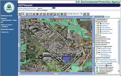
NEPAssist web site screen.
(Source: Texas Capital Area Metropolitan Planning Organization.)
Program Benefits
- The Capital Area Metropolitan Planning Organization’s (CAMPO) program provides a holistic, long-range regional planning guide for future transportation projects.
- Identifies regional historic preservation constraints and opportunities that can be used to reduce future project costs and schedules, in addition to preserving places of historic and cultural value.
- Coordination between CAMPO, Texas DOT, and the Federal Highway Administration has strengthened because of the program.
In 2006, the Capital Area Metropolitan Planning Organization (CAMPO) of central Texas improved its Geographic Information System (GIS) database as part of an update of its long-range regional plan. The database improvement and plan update were in response to Sections 6001 and 6002 of SAFETEA-LU. CAMPO is composed of Bastrop, Caldwell, Hays, Travis, and Williamson counties, centered on the City of Austin, the State capital. To meet the needs of its growing population, CAMPO, in conjunction with Federal, state, and local agencies, sponsored three workshops or “summits” to update the regional plan. The first summit included a presentation by the Texas Department of Transportation (TxDOT) on their Geographic Information System (GIS) database – GIS Screening Tool (GISST). GISST defines and ranks areas of environmental concern within a proposed project area, producing a measure of “environmental significance.” TxDOT uses GISST as a screening tool to help evaluate environmental impacts of proposed projects under the National Environmental Policy Act (NEPA) review process. In subsequent summits (2008), participants added data to GISST, including information on historic properties, provided by the Texas State Historic Preservation Office (SHPO). CAMPO then incorporated GISST into its own GIS database, and generated a “Sum of All Criteria” map showing the combined environmental and historic property data for the region.
CAMPO continues to hold yearly meetings with resources agencies for planning purposes. In addition, CAMPO has introduced regional workshops into the program, where agencies can share new data and information. CAMPO is now in the process of incorporating another GIS screening tool, NEPAssist, into the project analysis process. NEPAssist, developed by the Environmental Protection Agency (EPA), is a web-based application that draws environmental data from EPA region GIS databases. In this manner, CAMPO continues to build its planning capabilities by using existing GIS environmental data and screening applications to produce analytical tools that are uniquely suited to its needs.
Setting Up the Program
Program Elements
- Historic Preservation in Transportation Planning
- Interagency Cooperation and Collaboration
- Geographic Information Systems
- Historic Property Database
- Historic Property Screening Tool
- Historic Property “Red Flags”
CAMPO established a working group composed of its regional planning partners, including the Texas Historical Commission (i.e., the SHPO), to provide input and guidance on updating the regional plan and improving the GIS database.
The Planning Director at CAMPO was the driving force behind the effort to update the regional plan and improve the database. Prior to implementing this initiative, CAMPO staff had to secure approval on the technical aspects of the plan update from CAMPO’s Technical Advisory Committee, and then had to convince the Transportation Policy Board on the value of the initiative.
Four staff members, including the Planning Director and CAMPO’s GIS expert, worked on the initiative. The initiative was funded using CAMPO’s regular planning monies, and covered salaries, supplies, and meeting costs.
Challenges Encountered
CAMPO staff acquired a variety of data sets for updating their GIS database; however, the quality and outdated nature of some of the data presented problems.
Historic properties were not originally included in the database; however, CAMPO staff subsequently asked the SHPO for their cultural resource GIS data, which the SHPO provided.
Program Maintenance

Texas State House, Austin, Texas
(Source: Texas Capital Area Metropolitan
Planning Organization.)
CAMPO updated the long-range plan in 2010. These updates include analyzing projects using such tools as NEPAssist, which includes data from the National Register of Historic Places. Integrating NEPAssist into the project development process is still in development.
Program funding levels are the same as when the program was initially created.
Having enough staff time devoted to the program remains the biggest challenge. Currently, CAMPO can only have one full-time staff person devoting one-third of their time to working on the required environmental analyses. CAMPO will add new program staff in 2012 and 2013, so this staff issue may be resolved soon.
The current negative economic environment has actually helped the program in some ways. With fewer funds available for projects, regional partners seem to be more interested in getting projects to move more quickly, keeping the projects on schedule. This has resulted in better coordination among the regional partners, particularly in terms of environmental and historic property analyses.
TxDOT is looking to improve its NEPA process, making it more efficient. In 2012, TxDOT will most likely be making changes to its environmental analysis requirements. This will result in increased coordination among agencies, and more responsibilities for the CAMPO local jurisdictions. There also may be an increased reliance on CAMPO’s environmental analysis tools.
Critical Factors for a Successful Program
360 Bridge, Austin, Texas
(Source: Texas Capital Area Metropolitan Planning Organization.)
One critical factor is keeping the program moving forward in between long-range plan updates. The success of the CAMPO program requires ongoing workshops, meetings, and information exchanges in order to keep partners interested and active.
When NEPAssist is fully incorporated, it may replace the GISST analysis. This would make the analysis more efficient and easier to incorporate into the planning process at all levels.
The program’s real success has come from strengthened coordination between CAMPO environmental planners and the TxDOT environmental staff who prepare NEPA documents. The roles and responsibilities of streamlining the NEPA analysis and determining what CAMPO can do to help that process are still evolving. In retrospect, the program would have been more successful if CAMPO had worked with its partners to establish clear roles and responsibilities for program coordination earlier in the planning process.
June 1, 2012

