Stormwater Best Management Practices in an Ultra-Urban Setting: Selection and Monitoring
Fact Sheet - Infiltration Basin
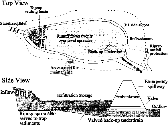
An infiltration basin is a shallow depression created by excavation or berming that captures stormwater and stores it until it can infiltrate into the soil (Figure 5). Infiltration basins typically serve drainage areas from 2 to 20 ha (5 to 50 ac). In an ultra-urban setting it is strongly recommended that they be used in an off-line configuration because sediment accumulation and particulates from stormwater runoff can clog the system. The principal advantages of infiltration basins are that they help preserve the natural water balance of a site, they can serve large or small developments, and they can be integrated into a site's landscaping or open space. If the area served is less than 2 ha (5 ac), an infiltration trench is usually the preferred BMP.
Infiltration basins provide the majority of treatment by processes related to soil infiltration, which include absorption, precipitation, trapping, straining, and bacterial degradation. That the soils below infiltration basins are effective filters is best indicated by the tendency for these soils to clog if heavily loaded with oil, grease, and sediment. The extent of sorption and filtration is a function of the soil type; for example, highly permeable soils (i.e., sandy soils) usually have low cation exchange capacities (CECs, or the affinity for capturing positively charged pollutants). The majority of infiltration basins are placed in highly permeable soils. However, as the basin is used, fine material suspended in stormwater is captured within the natural soil, creating a more effective straining matrix and potentially increasing pollutant removal. There is limited information available on chemical/biological changes in the soils surrounding infiltration basins and the extent to which the soils operate aerobically and anaerobically.
Applicability
Infiltration basins are appropriate only where there is ample room for installation. The basin can occupy an area between two and four percent of the upstream impervious area, but can be placed in confined spaces if necessary. These facilities are ideal for siting in interchanges and areas adjacent to roadways. The primary highway application for an infiltration basin is along roadways where runoff conveyed in a grassed swale can be diverted into the basin in areas where groundwater is not used for drinking purposes.
Infiltration basins are a relatively inflexible BMP primarily because a successful design requires soils with a reasonably high infiltration rate. If a high-infiltration-rate soil is not present, then the surface of the basin will become prohibitively large. If the proper soils are present, the designer is free to establish the basin width and length based on local constraints. Infiltration basins can be any shape; in fact, many review agencies are advocating nonrectangular shapes, which create aesthetically pleasing earth forms. Infiltration basins add an aesthetic value to roadside areas as long as they are maintained and litter and debris are regularly removed.
Effectiveness
Effectiveness is a function of the fraction of stormwater infiltrated. The amount of stormwater that bypasses the system due to overflow during large storm events or that cannot be absorbed by the system determines infiltration effectiveness. To date, only limited data are available on the intensity and amount of pollutants discharged to surficial groundwater aquifers from infiltration basins. Removal rates (in percent) reported for three different design sizes are shown in Table 8.
In variable climates, harsh winter temperatures can freeze the infiltration basins and when frozen, infiltration basins will not provide pollutant removal. Local meteorologic records should be obtained to verify the mean monthly average low temperature remains above freezing.
Table 8. Estimated pollutant removal effectiveness for infiltration basins (%)
| TSS |
TP |
TN |
Metals |
BOD |
Bacteria |
Comments |
| 75 |
50 - 55 |
45 - 55 |
75 - 80 |
70 |
75 |
Capture of 12.7 mm (0.5 in) of runoff (first flush) |
| 99 |
65 - 75 |
60 - 70 |
95 - 99 |
80 |
90 |
Capture of 25.4 mm (1 in) of runoff |
| 90 |
60 - 70 |
55 - 60 |
85 - 90 |
80 |
90 |
Capture of 50.8 mm (2 in) of runoff |
| Source: Schueler (1987). |
Siting and Design Considerations
Infiltration basins can be installed where there is sufficient surface area and soil infiltration capacity. Given the general lack of open surface area in the ultra-urban setting, infiltration trenches are generally more applicable than infiltration basins. However, infiltration basins can be employed wherever large redevelopment efforts are planned or along roadways where there is sufficient right-of-way available.
Groundwater is one key issue in siting infiltration basins. For ultra-urban applications, the surface aquifer under many municipalities is not used as a drinking water source, however, in some areas it is the surface aquifer directly connected to a drinking water aquifer. Nevertheless, most states or municipalities have developed rules regarding the placement of any facilities that discharge to the groundwater, which must be researched by the designer. As a general rule a minimum buffer between the basin invert and the seasonal high groundwater level of 0.6 to 1.2 m (2 to 4 ft) is typically used in the eastern United States in areas where water table depths are relatively shallow, while 3 m (10 ft) is the buffer distance used in some western states (Dorman et al., 1996).
Infiltration basins can be designed in a number of ways. Often, infiltration basins are designed as stand-alone facilities to provide water quality management-a design that infiltrates the 2-year runoff event. As an alternative, infiltration basins are sometimes combined with detention ponds to provide both stormwater quality and quantity management. This arrangement yields multiple benefits: the detention pond provides pretreatment for the basin and provides flood protection, and the infiltration basin can be located off-line, where it is protected from high flows (Young et al., 1996).
Pretreatment is considered crucial to sustaining the performance of infiltration basins; infiltration basins are often preceded by detention ponds, grassed swales, and filter strips. Additional design examples and information can be found in Urban Drainage Design Manual Hydraulic Engineering Circular 22 (Brown et al., 1996), Evaluation and Management of Highway Runoff Water Quality (Young et al., 1996), and Design and Construction of Urban Stormwater Management Systems (ASCE, 1992).
The performance of infiltration basins can be improved by keeping the infiltration area large, ensuring the bottom is flat, and vegetating with a dense turf of water-tolerant grass (Livingston, 1995). The actual size of the basin footprint is dependent on long-term meteorologic trends, the site's demonstrated minimum infiltration rate, and the dewatering time.
Construction activities will greatly affect the performance of infiltration basins and the potential for failure. It is critical to install the basin only after the construction site has been stabilized to minimize introduction of fine sediment into the basin. In one study, approximately 40 percent of the investigated basins had partially or totally clogged within their first few years of operation. Many of these systems failed almost immediately after construction (MDE, 1986). During excavation, compaction of the bottom and sides of the infiltration basin must be minimized by using vehicles equipped with oversized tires. The infiltration basin should be marked off or bermed prior to any construction activity to ensure vehicle entrance to the footprint area is not possible.
Maintenance Considerations
Routine and nonroutine maintenance is required to keep infiltration basins operating effectively. Infiltration basins should be inspected following major storms, especially in the first few months after construction. If stormwater remains in the system beyond the design drawdown time (typically 72 to 96 hours), either the infiltration capacity was overestimated or maintenance is needed.
Routine, periodic maintenance typically involves moderate costs. Periodic maintenance includes removing debris (litter, leaves, brush), mowing the sides and bottom once growth exceeds 0.3 m (12 in) in height, and revegetating eroded or barren areas. However, mowing is not necessary to maintain performance. If mowed, grass clippings should be removed to prevent clogging of the surface. It is recommended that the side wall slope be 3 (horizontal) to 1 (vertical) or flatter to help sustain vegetation, permit access for maintenance, and ensure public safety and ease of mowing. However, side slopes of 2:1 have been used successfully.
Occasionally, nonroutine maintenance or basin rehabilitation may be required, which can be costly, if clogging occurs. As a part of nonroutine maintenance, deep tilling every 5 to 10 years to break up the clogged surface layers followed by regrading and revegetating is recommended. This may include removing any accumulated sediment; sediment removal should be performed only when the soil surface is in a very dry condition to avoid compaction of the basin bottom (Livingston, 1995). For infiltration basins it is important to avoid the use of herbicides and fertilizers on grassed portions of the strip since these applications can directly contribute undesirable pollutants to waterways.
Cost Considerations
Infiltration basins are moderate-cost BMPs. The principal cost to install relates to earth moving and construction costs and installation of inlet systems. The construction cost can be estimated from the following equation, where V is the volume of stormwater managed in cubic meters (Schueler, 1987):
C = 13.9 ( V / 0.02832 )0.69
Note that the cost estimate obtained should be used for conceptual cost estimating only and is in terms of 1995 dollars.
References
ASCE. 1992. Design and Construction of Urban Stormwater Management Systems. The Urban Water Resources Research Council of the American Society of Civil Engineers (ASCE) and the Water Environment Federation. American Society of Civil Engineers, New York, NY.
Brown, S.A., S.M. Stein, and J.C. Warner. 1996. Urban Drainage Design Manual Hydraulic Engineering Circular 22. FHWA-SA-96-078. Federal Highway Administration, Office of Technology Applications.
Dorman, M.E., T.S. George, J.P. Hartigan, and T.F. Quasebarth. 1996. Retention, Detention, and Overland Flow for Pollutant Removal from Highway Stormwater Runoff. Volume II: Design Guidelines. FHWA-RD-96-096, Federal Highway Administration, Office of Research, Development, and Technology.
Livingston, E.H. 1995. "Infiltration Practices: The Good, the Bad, and the Ugly." In Proceedings of a National Conference on Urban Runoff Management: Enhancing Urban Watershed Management at the Local, County, and State Levels. March 30-April 2, 1993, Chicago, Illinois. U.S. Environmental Protection Agency, Center for Environmental Research Information. EPA/625/R-95/003.
Maryland Department of the Environment (MDE). 1986. Maintenance of Stormwater Management Structures: A Departmental Summary. Maryland Department of the Environment, Sediment and Stormwater Division, Annapolis, MD, and Maryland Department of Natural Resources, Water Resources Administration, Annapolis, MD.
Schueler, T.R. 1987. Controlling Urban Runoff: A Practical Manual for Planning and Designing Urban BMPs. Metropolitan Washington Council of Governments, Washington, DC.
Young, G.K., S. Stein, P. Cole, T. Kammer, F. Graziano, and F. Bank. 1996. Evaluation and Management of Highway Runoff Water Quality. FHWA-PD-96-032. Federal Highway Administration, Office of Environment and Planning.
|

