Stormwater Best Management Practices in an Ultra-Urban Setting: Selection and Monitoring
Monitoring Case Study-Vegetated Water Quality Buffer Strips, Austin, Texas
This case study is based on a study of vegetated buffer strips by Glick et al. (1993).
A field study to determine the influence of vegetation composition, buffer width, and infiltration rate on the effectiveness of native vegetation buffer zones for treatment of urban runoff was conducted. The study site was located in Austin, Texas, with the runoff originating in a parking lot with a drainage area of approximately 1 ha (2.47 ac). The soil on the site is categorized as shallow, well-drained clay overlying limestone; however, some of the soil in the buffer strips was fill from construction of the parking lot. Four different vegetation compositions were used as stormwater runoff treatment areas (1) mowed native grasses, (2) unmowed native grasses, (3) wooded area cleared, and (4) wooded area with woody debris. A grant from the Department of the Interior, U.S. Geological Survey, through the Texas Water Resource Institute was provided to fund the study. Additional non-Federal matching funds were provided by the City of Austin, Texas.
Study Objective
-
Determine the influence of vegetation composition, slope, buffer width, and infiltration rate on the effectiveness of native vegetation buffer zones as water quality BMPs.
Design and Operation
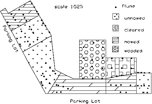
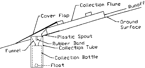
The field study developed to monitor the pollutant removal efficiency of different water quality buffer zones was established adjacent to an existing parking lot in Austin, Texas. Test plots were established to monitor the runoff quality through the buffer. Each plot was approximately 10 m (32.8 ft) by 20 m (65.6 ft) in size. The vegetation types included mowed native grasses (3 plots), unmowed native grasses (3 plots), undisturbed woodland (1 plot), and cleared woodland (1 plot). The vegetation in the mowed and unmowed areas was primarily composed of Johnson grass, Bermuda grass, and mixed legumes. The grassed buffer was followed by a wooded buffer dominated by common red cedar with scattered live oak and Ashe juniper. The ground cover was juniper debris and scattered Texas wintergrass. Figure 64 shows the test plot configuration for the field study site. Water sampling devices were constructed using a series of overland flow collection flumes that were placed at four locations in each of the eight test plots. In the wooded areas, only three locations were used because of parkland restrictions on land clearing. Four flumes were placed at each sampling location (see Figure 64). The slope of the test site was approximately 10 percent between the entrance of the mowed area to about one-third into the unmowed area. Elsewhere, the slope was between 17 and 30 percent. Sample bottles were placed in sample tubes only when a rainfall event greater than 10 mm (0.39 in) was likely. This was done to reduce sample bottle contamination. Bottles were collected and sent for laboratory analyses if more than one-half of the bottles were at least half full. If the bottles could not be collected for analysis within 36 hours after placement, they were emptied and cleaned for future use. Figure 65 shows a typical collection flume and collection bottle layout.
Infiltration characteristics for each of the four test plots were determined using adjacent areas with similar slope, soil, and vegetation for each strip to prevent any disturbances of the test sites. A drip-type rainfall simulator was used to produce runoff on the adjacent similar plots. The simulated rainfall was applied at a rate of 150 mm/hr (5.8 in/hr) for 1 hour or until the final infiltration rate was reached. The runoff was collected and weighed every five minutes. Infiltration was computed as the arithmetic difference between the applied rainfall and the collected runoff. The infiltration test was repeated on each slope and vegetation type except the cleared woodland. The infiltration characteristics could not be determined on cleared woodland due to restrictions in the amount of land that could be cleared in the city park.
Monitoring Program
The goal of the buffer strip monitoring program was to collect as many samples as possible between July 1990 and October 1991. For each grass sample collected, 12 runoff pollutant constituents were measured: fecal streptococci (FS), fecal coliform (FC), dissolved nitrate (D NO3-N), total nitrate (T NO3-N), dissolved total phosphorus (D TP), total phosphorus (TP), dissolved ammonia (D NH3-N), total ammonia (T NH3-N), dissolved total Kjeldahl nitrogen (D TKN), total Kjeldahl nitrogen (T TKN), total lead (Pb), and total suspended solids (TSS); however, only constituents that were found to be statistically different at the 0.10 level of significance were reported. Because dissolved samples were not collected in the cleared or wooded areas due to space limitations, only seven runoff pollutant constituents were measured in those areas. Analyses of variance were conducted to determine the individual effects of vegetation composition and buffer width and the combined effect of the treatments on buffer effectiveness.
Water samples were collected from 12 rainfall events that occurred during the monitoring program, specifically 425 samples of the total pollutants and 125 samples for the dissolved pollutants were collected. The samples from three of the flumes at each location were analyzed for TSS, TKN, T NH3-N, T NO3-N, TP, Pb, and FC. Standard USEPA testing protocols were followed for each analysis. The fourth sample at each grass location was tested for D NH3-N, D NO3-N, D TKN, D TP, and FS. Mean concentrations for pollutants that showed a significant difference (0.10 level of significance) due to buffer width are given in Table 39. Table 40 gives the mean concentrations for pollutants that showed significant difference (0.10 level of significance) due to the type of vegetative cover. A dash (-) in Table 40 indicates that the parameter was not measured due to space restrictions.
Conclusions
-
Infiltration results showed that mowed areas had final infiltration rates of 30 to 80 mm/h (1.1 to 3.1 in/h), unmowed areas had infiltration rates of 110 to 140 mm/h (4.2 to 5.4 in/h), and the wooded areas had infiltration rates greater than 140 mm/h (5.4 in/h). These results indicate that infiltration capacity and vegetative cover are highly correlated.
-
Seven of the 12 pollutants tested in the study (TSS, Pb, T TP, T TKN, T NO3, D TP, and D NO3) exhibited a significant relationship between concentration and vegetative cover and buffer width. Vegetative cover was a significant factor for five pollutants (Pb, TSS, T TKN, D TP, and D NO3-N). Vegetative composition of the buffer influences its effectiveness.
-
Examination of the infiltration rates shows that the wooded area had the greatest infiltration rate; however, the mean pollutant concentrations for total pollutants also were the highest. It appears that the infiltration rate is a secondary influence on buffer strip performance with type of vegetation and ground cover being the primary factors.
-
Of the five pollutants that had buffer width as a significant factor, only D NO3-N had a lower concentration at the end of the buffer compared to the start. From the data gathered, it appears that buffer width negatively influences buffer performance.
-
The effects of changing the slope are inconclusive. The slope of the buffer changed at 4 m (13 ft) in the mowed and unmowed areas; the difference in the change in concentration between 0 and 4 m (13 ft) and 4 and 8 m (26 ft) was found not to be statistically significant.
References
Glick, R.H., M.L. Wolfe, and T.L. Thurow. 1993. Effectiveness of Native Species Buffer Zones for Nonstructural Treatment of Urban Runoff. Texas Water Resources Institute, College Station, TX.
|

