Awards
Exemplary Ecosystem Initiatives — 2011
California: Essential Habitat Connectivity Project
The Essential Habitat Connectivity Project brought multiple agencies together to identify natural connectivity corridors and potential habitat barriers for California's eight ecoregions. The California Department of Transportation, California Department of Fish and Game, and Federal Highway Administration, California Division initiated this interagency collaboration which developed a statewide map, spatial databases, and accompanying guidance. A total of 62 partner agencies supported the project, with 23 contributing under a technical advisory group and 4 acting as the steering committee.
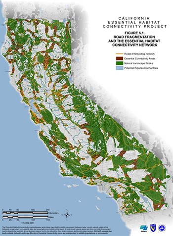
The Essential Connectivity Map demonstrates wildlife habitat networks using a Geographic Information System (GIS)-based approach and identifies connectivity corridors that are essential to maintaining these networks. The map identifies 850 large, existing blocks of natural habitats designated as “Natural Landscape Blocks” and 192 “Essential Connectivity Areas,” which link the habitat blocks together. Many Federal, State, and designated conservation lands are included within Natural Landscape Blocks and Essential Connectivity Areas. However, the analysis was based on the ecological condition of the land, independent of ownership or protection status.
The data used to build the Essential Connectivity Map includes specific characteristics of the Essential Connectivity Areas, including size, physical and biological features, property ownership, intersecting roadways, and biodiversity. Using this data, the Essential Connectivity Map shows that each Essential Connectivity Area supports many species considered threatened or endangered under the Federal Endangered Species Act. The extensive information contained in the data also supports the development of future maps and analyses.
Along with the Essential Connectivity Map and GIS data, the project produced a statewide strategy document to provide guidance on modeling natural habitats and the connections between them. This document helps users to understand the Essential Connectivity Map and provides a framework for performing habitat connectivity analyses at local and regional scales. With this guidance, users can easily interpret and use the map and GIS databases to develop detailed connectivity analyses about localities and regions of interest.
The Essential Habitat Connectivity Project demonstrates collaboration and interagency partnerships in developing a multi-purpose map and databases, along with guidance for strategic approaches to encourage long-lasting use of these products. The map's supporting data can easily be adapted for use by other agencies and in local and regional planning efforts. By integrating a user-friendly approach into these GIS-supported tools, the Essential Habitat Connectivity Project helps end users implement strategies to minimize impacts to essential connectivity areas, and identify appropriate locations for future infrastructure projects and conservation investments.
For more information, contact Amy Pettler, California Department of Transportation, at amy_pettler@dot.ca.gov; Monica Parisi, California Department of Fish and Game, at mparisi@dfg.ca.gov; or Larry Vinzant, Federal Highway Administration, California Division, at larry.vinzant@dot.gov.
Final connectivity map indicating natural landscape blocks (green), essential connectivity areas (brown), and road network (yellow).

Figure 1: This figure depicts the final connectivity map including Natural Landscape Blocks and Essential Connectivity Areas as well as the road network which it intersects with. Note that 552 Natural Landscape Block pairs and 192 Essential Connectivity Areas are fragmented by roads.
Source: California Department of Transportation
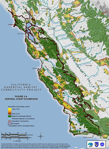
The Central Coast Ecoregion Map, shown here, is an example of the specific maps created under this project for each ecoregion in California.

Figure 2: An example at the regional extent is the Central Coast Ecoregion. Maps for each ecoregion are presented in the Final Report at http://www.dfg.ca.gov/habcon/connectivity/. -content is no longer available.
Source: California Department of Transportation

