CASE STUDIES
California: Riverside County Integrated Project
Agencies and Organizations
- Federal Highway Administration (FHWA)
- U.S. Army Corps of Engineers (USACE)
- U.S. Environmental Protection Agency (EPA)
- U.S. Fish and Wildlife Service (USFWS)
- U.S. Forest Service (USFS)
- California Department of Transportation (Caltrans)
- California Resources Agency (CRA)
- California Business, Transportation, and Housing Agency
- Governor’s Office of Planning and Research
- Santa Ana Regional Water Control Board
- Riverside County Government
- Natural Resources Conservation Service (NRCS)
For additional information, please contact Cathy Bechtel, Project Delivery Director, CETAP, Riverside County Transportation Commission, at (951) 787-7934 or cbechtel@rctc.org.
Section 1: Overview
Riverside County is part of the Los Angeles metropolitan area, located north of Orange County and east of Los Angeles County. The county has experienced rapid population and economic growth; its population was approximately 1.5 million in 1999 and is expected to double to 3.0 million by 2020. The county is also one of the largest in the Nation, with 7,300 square miles of urban, rural, and undeveloped land. To improve the quality of life for current and future residents, the Riverside County government and the Riverside County Transportation Commission began a comprehensive planning process to ensure transportation, land use, and environmental planning are coherent and consistent.
The Riverside County Integrated Project (RCIP) incorporates three formerly distinct plans that affect the placement of buildings, roads, and open spaces in the county. The project includes a General Plan for land use and housing, a Multiple Species Habitat Conservation Plan (MSHCP) to determine which land should be set aside as open space and maintained for plant and animal conservation, and the Community and Environmental Transportation Acceptability Process (CETAP) identifying improvements for highways and transit systems.
In 1999, the Riverside County Board of Supervisors endorsed 15 planning principles that would guide the RCIP planning process. The first step was to create a vision statement that captured how county residents perceived their current quality of life and the future they desired for their communities. This document established goals for each of the three component plans (see figure 1).
Figure 1. The overall RCIP model shows that input from the Western Riverside Council of Governments (WRCOG) and Coachella Valley Association of Governments (CVAG) was also included.
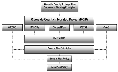
The public and other community stakeholders participating in advisory committees developed an accurate and useful Vision Statement. Several members of each advisory committee then formed a Steering Committee to coordinate implementation of the Vision Statement in each of the three planning processes and make recommendations to the County Board of Supervisors. While each of the component plans could be implemented individually, the Steering Committee coordination ensured that if any combination of the three were passed, they would be integrated and harmonized. An example of this inter-relationship is the Circulation Element of the General Plan for land use. The highway portion is almost completely based on the priority transportation corridors laid out in CETAP.
CETAP, the transportation component of RCIP, focuses on two internal corridors and two inter county corridors. Congestion in western Riverside County, along with predicted levels of population growth, makes the investment in new transportation corridors critical to the future of the county. Riverside County chose a tiered National Environmental Policy Act (NEPA) approach to identify the transportation corridors in long-range plans, while incorporating the long-range land-use and environmental planning being outlined in the RCIP. The CETAP transportation corridor planning project was identified as a priority project in EO 13274, which has led to increased support and scrutiny of the corridor planning by Federal agencies, including FHWA, EPA, and others. Additional funding and staff support was also provided through this identification.
The Tier 1 document for each corridor addresses impacts and alternative rights-of-way, leaving details of the design, mitigation, and permitting information to the Tier 2 analysis. The north/south Winchester to Temecula corridor completed a Final Environmental Impact Statement (FEIS) and Record of Decision (ROD) on the Tier 1 analysis in 2003.The north/south corridor is undergoing a Tier 2 NEPA evaluation in 2007. Due to more complicated concerns over the east/west Hemet to Corona corridor alignment, CETAP abandoned the Tier 1 study and is currently completing a project-level EIS.
Section 2: Data and Tools
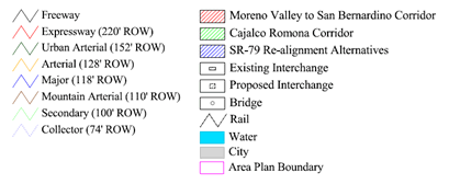
Figure 2. A zoom view of the General Plan circulation map showing the Cajalco Romona Corridor
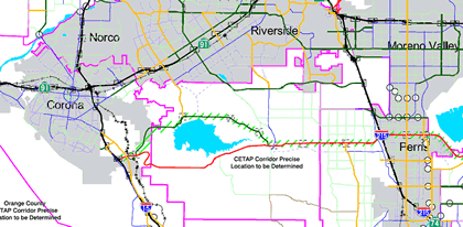
Maps from CETAP, the General Plan for land use, and MSHCP were overlaid to ensure consistency between the various elements of the RCIP. Figure 2 shows how the transportation and conservation elements of CETAP and MSHCP are shown in the General Plan. Consultants used geographic information systems (GIS) to create data layers and overlays for each component plan.
However, the GIS department of the Riverside County Transportation and Land Management Agency is responsible for keeping the data up to date going forward. During the development of RCIP, residents could view, through an online mapping program, how planned projects from the RCIP might affect their areas. This mapping program was available to any member of the general public and generated sustained interest from the community in the planning process.
Section 3: Scheduled Cooperation and Interaction Processes
CETAP agency representatives from EPA, FHWA, USACE, and USFWS worked together to narrow the list of possible corridor alternatives from 14 down to 2 corridors. The north/south Winchester to Temecula corridor and the east/west Hemet to Corona corridor were selected by eliminating the most environmentally harmful alternatives. This early coordination between agencies fostered important relationships between agency representatives that would prove critical in the subsequent tiered NEPA approach. Many of these delegates continued to work on the project from beginning to end.
Resource agency project committees had frequent face-to-face meetings and conference calls at the beginning of the project, and continue to meet at least monthly. The level of effort from resource agencies was reported to be high overall for the project, which created some strain on the other functions of the agencies. At one point, there was a weekly call with all resource agencies to review the status of the project.
CETAP meetings were originally facilitated by the RCIP headquarters office. Later in the process, a third-party facilitator was introduced. This facilitator assisted the CETAP corridor project teams in synthesizing ideas, targeting discussions, and reaching conclusions.
Participants found that environmental laws and streamlining practices, such as integrating NEPA and section 404 of the Clean Water Act, were not conducive to tiered levels of study due to lack of guidance. Resource agencies found it difficult to agree on the level of detail that would be presented in a Tier 1 analysis.
In addition to resource agency involvement, each of the three component plans had a 30-member stakeholder committee made up of representatives from environmental groups, the building industry, community leaders, and property owners. These groups met regularly. Staff working on the process felt that the extensive public outreach and government relations work showed its worth as the community coalesced around the plan elements.
Section 4: Legal Framework
The RCIP Logo

Only the land use portion of the RCIP is required under California State law (Government Code Section 65300), and an update was due to the existing plan, which was adopted in 1984.
A Partnership Action Plan was signed in September 2000 prior to development of the RCIP plan. The agreement was important in cementing the commitment of several critical Federal, State, and local agencies to working cooperatively on all three components of the RCIP. Federal partners included EPA, USACE, USFS, USFWS, and NRCS. At the State and regional levels, Caltrans; CRA; the California Business, Transportation, and Housing Agency; the Governor’s Office of Planning and Research; and the Santa Ana Regional Water Control Board signed the agreement.
In addition, the Riverside Transportation Commission, EPA, USFWS, USACE, and FHWA signed a memorandum of understanding (MOU) to establish and record the information necessary to proceed with a final Tier 1 NEPA document. Concurrent reviews were also a key component of completing the CETAS. Federal, State, and local agencies received all NEPA review documents at the same time rather than going from one agency to the next with potentially conflicting comments.
Section 5: Leadership Role
Changing the planning process is difficult for agency staff without guidance documents and input from supervisors. EO 13274 brought national attention to the transportation portion of the RCIP and placed increased pressure on the transportation planners and resource agencies at work. As a result, one of the critical elements to RCIP success was staff’s ability to elevate the issues to a supervisory level within each agency. This was especially important in the Tier 1 NEPA documents for the transportation component since resource staff did not have experience with this type of review. Staff needed ongoing support from their supervisors to deviate from their standard procedures and support a Tier 1 process. Having high-level Federal agency staff available, particularly at FHWA, also helped clarify issues for field offices and provide early feedback.
Strong leadership was also provided by the county supervisor, who was instrumental in securing the Federal and State support for RCIP. His leadership maintained political and financial support even when RCIP overran initial cost and time estimates. Leadership was also provided by FHWA, particularly with regard to identification and development of the transportation corridors. This role proved critical once E O 13274 designated the project as one of the national priority projects.
Section 6: Funding Sources and Liaisons
Participating agencies completed work on RCIP with existing staff, which often required shifting responsibilities and priorities to accommodate the project planning work. Consultants were also hired to coordinate efforts between agencies on a daily basis and to do public and government relations and outreach.
Riverside County provided a major share of the funding for the RCIP process from State funds set aside for updating the General Plan for land use.
The Transportation, Community, and System Preservation (TCSP) program provided additional grant funding for RCIP. The TCSP program was created under the Transportation Equity Act for the 21st Century (TEA-21). Section 1309 of the act calls for coordinated environmental review with FHWA and other Federal agencies. Caltrans used these Federal funds to provide additional staff and resources to resource agencies in order to meet deadlines for environmental review.
Section 7: Performance Measures and Outcomes
The transportation corridor planning portion of the study has progressed through Tier 1 review for the north/south Winchester to Temecula corridor, reaching an ROD by FHWA in 2003. However, there was some dispute over whether the Tier 1 document included enough detail since tiered environmental documents are still somewhat unusual and there was limited Federal guidance on the level of information necessary. After slight delay, the alternative corridor that was eventually chosen was agreed upon by FHWA, Caltrans, and the Federal resource agencies. The corridor is currently undergoing Tier 2 analyses.
The tiered approach was dropped on the east/west Hemet to Corona corridor, in part because The environmentally superior alternative was shown to have little transportation benefit. The project has moved from the transportation planning process to the project-level EIS process, with a different east/west corridor, the Mid- County Parkway from the San Jacinto area to the Corona area.
Although the tiered approach for the two CETAP corridors has encountered delays, CETAP participants believe the early involvement of stakeholders and integration with the General Plan and MSHCP will ensure that project permits are moved ahead quickly. A significant cause of the early delay were the number of major issues that Federal and State agencies identified for early discussion. In the long-term project development, the tiered approach requires all parties to agree to the level of analysis early on in the Tier 1 process in order to avoid delays later in the planning process. Another benefit of involving resource agencies in the early planning of both corridors was that the frequent meetings have improved relationships between the Federal and State agencies.
Section 8: Lessons Learned
- Third-party facilitation. Partway through the RCIP and CETAP development process, a third-party facilitator was contracted to mediate meetings. Staff at the Riverside County Transportation Commission noted that this was a major benefit to the group, which was composed of staff from a wide variety of backgrounds and disciplines.
- Political and supervisory support. Political pressure on the process was helpful in keeping the ball rolling toward success. Staff at participating agencies were kept motivated to achieve decisions with the political support of the County Board of Supervisors and the impetus of the EO on environmental streamlining. The support that leadership provided to staff involved in streamlining the review process increased the likelihood that potential issues and concerns were elevated as soon as they were identified. By involving high- level decision makers early in the process, they were sometimes able to avoid lengthy delays.
- Motivating procedural changes. During the transportation planning process, resource agencies were asked to change their internal review procedures and adopt faster processes for reviewing materials. To agencies already short on resources, the time and effort required to do so were unanticipated. Political pressure from Riverside County and the Federal Government was helpful here.
- Funding challenges. The RCIP process required significant additional funding for costs such as the third-party facilitation, general consultant support, and staff time at the agencies. The RCIP office was funded through a variety of sources, including the TCSP as well as general county funds. The county funded the project up front, covering costs of the project until grant funds were delivered. The county was challenged to maintain its funding support throughout the project’s lifespan.
- Setting ground rules. RCIP staff said that working out some agreements ahead of time would have been helpful, such as the level of information needed for different parts of the planning process. Up-front agreements on how to go through each process would have made it easier for the different agencies to move forward.
back to top

