CASE STUDIES
Texas: Texas Environmental Resource Stewards and Texas Ecological Assessment Protocol
Note: As a result of the success of this project,
EPA
Region 6 applied for and received an
FHWA
Eco-Logical grant, in the form of an Inter Agency Agreement to enhance and extend the Texas Ecological Assessment Protocol (TEAP). EPA will extend the
TEAP
from 18 ecoregions to 38 ecoregions forming a REAP (Regional Ecological Assessment Protocol) which will encompass Arkansas, Louisiana, New Mexico, Oklahoma, and Texas (South Central US). The
REAP
will also increase the current data resolution of 1.0 km2 to 0.25 km2. Further, the new REAP will include a planning and screening level assessment tool that uses existing
GIS
data to classify land based on ecological importance.
Agencies and Organizations Involved
- Federal Highway Administration (FHWA)
- U.S. Environmental Protection Agency (EPA), Region 6
- U.S. Army Corps of Engineers (USACE), Southwestern Division
- U.S. Fish and Wildlife Service (USFWS)
- Texas Governor’s Office
- Texas Commission on Environmental Quality (TCEQ)
- Texas Parks and Wildlife Department (TPWD)
- Texas Department of Transportation (TXDOT)
- The Nature Conservancy
For additional information, please contact Dr. Sharon Osowski of EPA Region 6 at (214) 665-7506 or osowski.sharon@epa.gov.
Section 1: Overview
In July 2002, Texas Environmental Resource Stewards (TERS) was established by the State of Texas in response to the Federal Transportation Equity Act for the 21st Century (TEA-21) and Governor Rick Perry’s State initiative to create the Trans-Texas Corridor, which includes the I-69 corridor.
TERS
is a two-tiered agency partnership between EPA Region 6, FHWA,
USACE,
USFWS, the Texas Governor’s Office,
TCEQ,
TPWD,
TXDOT, and The Nature Conservancy. The first tier is an executive-level team that provides oversight and vision. The second tier consists of a team of technical specialists from various organizations. This team was responsible for the development of an ecological assessment tool that maps resources in the State of Texas. This tool, the Texas Ecological Assessment Protocol (TEAP), is a model for interagency collaboration and streamlining using data and mapping of locations that TERS member agencies considered “ecologically important.”
Integrated Planning Applications
The initial goals of TERS were to identify ecologically important areas, identify potential mitigation areas, and streamline regulatory processes. Several transportation projects were in the planning stages (e.g., I-69, the Trans-Texas corridor) in 2001 and 2002, the size of which highlighted the need to identify and protect areas of high ecological sensitivity from disturbance. TERS members wished to begin collaboration between organizations earlier for these and other transportation projects and developed a vision to improve mutual understanding between organizations, using collective knowledge to support transportation decision making and create a long-lasting synergy.
Leaders from participating agencies began by identifying common environmental interests and target activities that would benefit each agency. Common interests included identification of ecologically important natural resource areas (wetland, aquatic, and terrestrial) for avoidance or potential compensatory mitigation, preservation, or restoration; streamlining regulatory processes; early identification of some National Environmental Policy Act (NEPA) requirements in project planning; and analysis of cumulative impacts. While the TERS leadership team continues to meet on a bi annual basis, TERS also established a separate team of technical specialists from seven member agencies to identify ecologically important areas, identify potential mitigation areas, and streamline regulatory processes.
TEAP was created cooperatively by Federal, State, and local agencies in response to the first TERS goal, to assess and identify ecologically important resources in the State. TEAP is based on an ”eco region” scale to account for the size of the State along with many diverse ecosystems. The eco region approach allows for large-scale analysis and preliminary screening to expedite overall analysis processes. TEAP is not an all-inclusive predictive model; rather, it identifies the top 1 percent of ecologically important areas in 18 eco regions using three criteria: the diversity, rarity, and sustainability of resources in each.
With this data, TEAP can be used to assess the entire State of Texas using a statewide geographic information system (GIS) grid. As a supplemental tool, TEAP can be used to identify
NEPA
requirements during project planning to reduce large corridors into more manageable areas for detailed investigation and flag potentially sensitive areas within each ecoregion. Identifying ecologically important areas allows planners to recognize, avoid, and minimize impacts to sensitive resources early in the planning process.
The results of TEAP are intended to be used for the following activities to support the NEPA planning process (scoping, alternatives development, etc.) and ecological assessment:
TEAP and TERS demonstrated the importance and benefits of interagency teamwork, as well as the importance of keeping a stable team throughout the process.
– John Machol, USACE
- Assist with planning, scoping, and analysis associated with meeting the requirements of NEPA.
- Streamline the authorization process of large projects by narrowing the study corridors necessary for further field investigation.
- Support mitigation discussions to avoid ecologically important areas, minimize impacts, and compensate for unavoidable impacts.
- TEAP is limited in that it is not intended to be used for determining site-specific ecosystem characteristics or producing exhaustive lists of environmental concerns for all locations. Recognizing these limitations is important in order to accurately market TEAP and its functions. Similarly, TEAP does not include integration with local land use decision processes. Opportunities and incentives for local land use planning agencies to participate in the system would create a more integrated planning framework. Nonetheless, TEAP effectively serves as a planning tool that allows for a more comprehensive review process through early screening of areas that might need additional analysis for ecological sensitivity.
Section 2: Data and Tools
The goal in developing TEAP was to demonstrate measurable results about ecologically sensitive areas in Texas that could be used effectively in conjunction with agency-specific information to support decisions. The model is designed to assess the State by eco region and identify the optimum ecological areas for protection and mitigation based on ecological theories, without consideration of political boundaries or existing regulatory programs.
EPA took on a significant role in development of TEAP, offering to adapt an ecological model that had been successfully implemented in Region 5 to conditions in Texas. That model, the Critical Ecosystem Assessment Model (CrEAM), is a prioritization tool that, given several options, selects the one option that has the least potential impact or is least vulnerable. TERS executives agreed with this approach and renamed the application the Texas Ecological Assessment Protocol. The results of TEAP were envisioned to be part of FHWA’s analysis and the modeling incorporated into existing GIS systems as new criteria.
To determine the best framework for the assessment tool, EPA reviewed existing data, studies, and methodologies. Given time, funding, and data constraints, TERS executives chose to focus solely on environmental and ecological conditions, and excluded historical and cultural resources. TERS identified three existing resources that would prove helpful in developing a framework for TEAP:
- An eco region analysis conducted by TPWD for its Land and Water Resources Conservation and Recreation Plan
- GIS-based analysis and portfolio assessments from The Nature Conservancy’s Eco-region Planning Process
- State Superfund data from TCEQ
These existing data sets were processed and analyzed jointly by EPA Region 6 and TPWD staff, while The Nature Conservancy verified the data against its own portfolio sites identified in the eco-regional planning process. The comparison showed that the areas ranked as highly important by TEAP corresponded closely to areas identified by The Nature Conservancy. Specifically, The assessment confirmed that the top 1 percent of ecologically important areas in the State were recognized by both TEAP’s process and The Nature Conservancy’s process.
Again, TEAP is comprised of three main layers: diversity, rarity, and sustainability, which are then separated into sub-layers. The diversity layer consists of land cover continuity and diversity and consists of four sub-layers: (1) appropriateness of land cover, (2) contiguous size of undeveloped area, (3) Shannon land cover diversity index1, and (4) ecologically significant stream segments. The rarity layer focuses on the scarcity of species and land cover and consists of four sub-layers: (1) vegetation rarity, (2) natural heritage rank, (3) taxonomic richness, and (4) rare species richness. Finally, the sustainability layer has two sub-layers: (1) resistance and (2) resilience, which describe the environment’s stability in terms of maintenance without human management. The layers were applied and averaged over 30 mega- pixels in each 1 km2 grid cell.
While TEAP is focused on ecological impacts, the results can be used in conjunction with other databases to show where public lands, transportation corridors, or watershed boundaries are located in relation to the ecologically important areas identified by TEAP. TERS agencies, local planning agencies, and the general public can request and use the TEAP data while overlaying other GIS layers of interest.
Figure 1. Composite map of diversity, rarity, and sustainability layers in the entire State of Texas
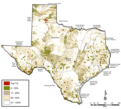
Figure 2. Composite map of the diversity, rarity, and sustainability layers in the Texas High Plains
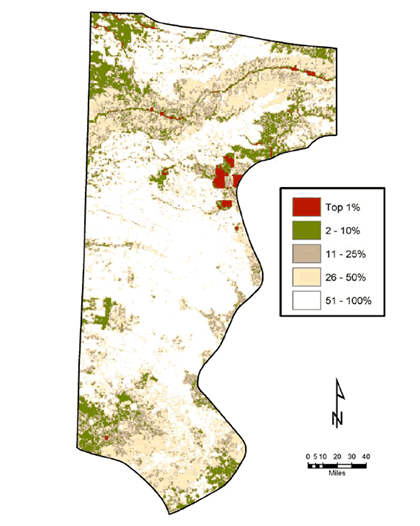
Figure 1 is a composite map of Texas that illustrates locations of the top 1 percent of the State’s ecologically important areas.
Figure 2 provides a close up of the Texas High Plains, showing the diversity, rarity, and sustainability layers. The red areas of this composite map represent higher ecological importance and the white areas represent lower ecological importance. For example, the Canadian River is highlighted at the 1 percent and 10 percent levels, and there is a larger riparian buffer at the 25 percent level. The northwest corner and an area southeast of the river are also highlighted and may have a high degree of rarity.
When developing TEAP, the major technical challenges were identified by the participating agencies as:
- Identifying a method that can appeal to all agencies involved. Once the method was agreed upon, finding appropriate data, determining calculations, and committing to the results became challenges.
- Acquiring and maintaining consistent and updated data. TPWD, the State agency responsible for the diversity and rarity modeling, found that acquiring sufficient input data was the most difficult task, especially for the diversity model. Decisions also had to be made about where and how the data should be stored.
- Addressing the sensitive nature of some of the endangered species data and determining how to best share sensitive data. In previous ecosystem database tools, TPWD was able to use password-protected sites for the endangered species data to protect its sensitivity. TEAP had to address similar concerns about the sensitive endangered species data that would be related to the diversity modeling.
- Maintaining awareness of the limitations associated with the data. The Nature Conservancy recognized there were limitations associated with the accuracy assessment that had to be properly addressed to have a full understanding of the scope of TEAP’s functions. TPWD also explained that limited access to private lands in Texas should be considered when screening any areas for ecologically important regions. Recognizing these limitations is important to grasp the utility of the tool.
At the time of its development, TEAP was expected to be reevaluated every 2 to 3 years, as new land cover and other data became available. These updates have not yet occurred due to funding restraints, but remain a goal for the program. Continually updating the data will allow for optimal utility of the tool. Other databases, including pipelines and oil and gas wells, may be incorporated in subsequent iterations of TEAP. At the time of its development, TEAP also determined that as soon as 2002 land cover data was available in GIS format, the updated analyses can be performed, providing a more up-to-date assessment tool. While these pending updates will be helpful for full utilization of TEAP, they had not occurred by 2007.
EPA plans to create protocols similar to TEAP in other States. However, since TEAP’s development was completed in 2005, there have been no other updates due to staff and executive turnover, in addition to a lack of additional funding.
Section 3: Scheduled Cooperation and Interaction Processes
TERS meetings were held every 6 months to provide general updates on the progress of TEAP and maintain executive-level interest in the initiative. These meetings were supplemented by regular telephone and e-mail exchanges at the staff level. As TEAP development began, EPA and TPWD were in contact weekly to perform calculations for the assessment tool. TPWD was critical for data collection development of the tool’s GIS component, and held several TEAP meetings at its GIS lab. Most participating agencies had a regulatory interest in the project and had the opportunity to be involved in the decision making.
All participating agencies involved in the development of TEAP were invited to submit comments on the draft pilot report. This opportunity for participating agencies to review and provide guidance on the project built a level of cooperative trust and strengthened existing relationships.
Section 4: Legal Framework
No legal framework was associated with either participation in the TERS regularly scheduled meetings or development of TEAP. The participation of each agency was entirely voluntary and based solely on agency executives’ resolve to work together to identify common solutions to planning transportation projects around ecologically sensitive areas. At the time of TEAP’s development, the participants in TERS were asked to identify possible opportunities and barriers for using the tool in each of their agencies. However, no formal, legal commitments, such as memoranda of understanding (MOUs), resulted from the analysis. Participation in TERS and use of TEAP remain voluntary and informal.
Section 5: Leadership Role
Development of TEAP was driven by both top-down and bottom-up leadership. The former is where TERS meetings brought an executive-level consensus to the project and provided necessary agency resources. The latter is where technical specialists, involved in development of TEAP, brought a perspective from the day-to-day workings of different agencies. Working relationships at these two levels helped identify common interests and target activities for collaborative ecosystem management more broadly.
Both TERS and TEAP benefited from the presence of a strong leader and project champion as a critical element of the project’s successful completion. EPA provided the forward-thinking leadership and technical approach that encouraged the team to consider innovative ideas to address the TERS vision. However, this reliance on a leader to stimulate ownership of TERS goals also hampered the growth of long-term inter agency cooperative relationships and establishment of formal agreements. Indeed, further implementation of the streamlining efforts begun with development of TEAP have stalled since staff turnover and agency focuses have shifted.
Section 6: Funding Sources and Liaisons
EPA, and FHWA indirectly, provided funding for TEAP development. FHWA provided funding to EPA for another geospatial mapping project, the Geographic Information System Screening Tool (GISST), which was leveraged for TEAP. EPA provided $100,000 toward development of TEAP and the associated GISST work, some of which was provided to TPWD for its data analysis and integration efforts.
TXDOT funded liaison positions at two resource agencies, which strengthened commitment to TERS and technical committee meetings. There are one and a half positions funded annually at TCEQ and one position at TPWD. Though these positions have been recognized since 1999, during the TERS development these liaisons assisted resource agencies with meeting their responsibilities as members of the team. The agency was able to apply staff knowledge of transportation projects, TXDOT operating procedures, and the NEPA process to TERS development.
Most participating agencies rearranged staff resources to contribute to the development of TEAP. TPWD indicated that high-level management expedited the staff reprioritization required to complete the data analysis. The team also availed itself of the existing resources within participating agencies, such as GIS labs, to save costs and overall development time. USACE also reported reallocating staff time from other projects in Texas to participate in TERS and development of TEAP. The Nature Conservancy delayed approximately 6 months of work so it could fulfill its responsibilities to conduct accuracy assessments of the TEAP data.
Section 7. Performance Measures and Outcomes
TEAP has proven to be a successful protocol and has already been used for several applications in Texas, including sections of the Trans-Texas Corridor (TTC). Large projects such as
TTC
challenge agency staffing, funding, and the ability to provide timely decisions if conducted in a “business-as-usual” manner. TTC is a statewide transportation network more than 4,000 miles in length (1,000 of which will be I -69).
Upon its completion, TEAP’s data was incorporated into
GISST. GISST allows for high-level corridor planning, which has been used to scope the TTC project. TX DOT is using GISST for Tier 1 analysis and planning of I-69.
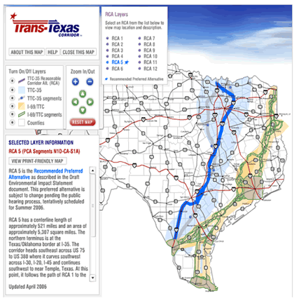
TEAP’s design allows it to reduce large corridors to more manageable areas for detailed investigation. As shown in figure 3, TXDOT used TEAP to assist in determining the preferred alternative, ultimately avoiding 80 percent of the ecological concerns identified by TPWD. The assessment tool allows for a high-level analysis of potential ecological areas of concern. This assessment approach improves agency ability to avoid ecologically sensitive areas instead of compensating for ecological and wetlands mitigation. While further field investigation is required following the high-level analysis, the tool nonetheless contributes to streamlined project planning and transportation decision making processes.
Figure 3. Screenshot of the Trans-Texas Corridor online tool with the preferred alternative shown
Section 8. Lessons Learned
Development of TEAP is an example of a synergistic project. The approach focused on combining knowledge and existing resources across agencies to support a larger initiative that might not be accomplished as successfully at a smaller scale. The interagency collaboration providing resources and data proved to be an effective use of agency resources and time. The subsequent tool provides measurable results that can improve the quality of agency decision making related to ecologically sensitive areas and transportation planning processes.
The team identified the following lessons learned from development of TEAP:
- A strong champion can help maintain momentum on large projects. An EPA representative was recognized as a champion who energized team members with her forward-thinking, proactive, and collaborative approach.
- Careful planning, timing, and consideration of each agency’s mission are critical for a multi agency technical project of such a large magnitude. Coordination is key when consensus must be reached on a variety of decisions. There must also be enough time allotted for comment and review from all agencies involved. Interagency consensus can only be achieved with careful planning that allows time for review and discussion.
- Basing a tool on existing models and methodology can expedite the process for assessment tool development. Building on existing data, resources, and collective knowledge is an efficient way to develop a multi agency assessment tool that can lend to productive decision making about ecologically sensitive areas.
- A high-level executive group can effectively guide staff-level process and buy-in. A representative from USACE explained that the high-level executive group TERS was able to provide the focus and guidance necessary to maintain a steady pace on development of the TEAP tool. The top-down approach guaranteed buy-in from agency management that proved to be helpful for staff-level participation.
- It is difficult but important to maintain continuity in order to follow up on necessary updates for an assessment tool. Without continuity, the goals may not be reached to continue to update the tool for its maximum potential as a project planning aid. A tool that is updated more frequently will likely be utilized to its full potential and function.
- Partnerships can extend from across agencies to other organizations. TERS included not only Federal and State agencies but the Director of Science and Stewardship at The Nature Conservancy. The Nature Conservancy utilized its Ecoregion Planning Process to provide preliminary accuracy assessments of TEAP results.
1 The Shannon land index is a common measure of the complexity of the land cover on the countryside, sometimes also called edge density.
back to top

