Planning and Environment Linkages
PLANNING AND ENVIRONMENT LINKAGES (PEL) HYPOTHETICAL CASE STUDY:
PLANNING STUDIES
View Printer-friendly
PDF
→
BACKGROUND
PEL is a valuable tool for creating efficiencies in the transportation project development process that supports agencies’ efforts to accelerate project delivery. PEL represents a collaborative and integrated approach to transportation decision-making that considers benefits and impacts of proposed transportation system improvements to the environment, community, and economy during the transportation planning process to inform the environmental review process.
This case study provides a hypothetical example for how a State Department of Transportation (DOT) could conduct a PEL study for a scenario with sensitive resources, potential environmental constraints, and multimodal considerations with the potential for many alternative solutions. PEL studies are developed with the stated purpose of producing planning analyses and decisions that can be adopted and/or incorporated into subsequent project-level environmental reviews. This can be used when sensitive resources are known to be present, but additional information is needed to avoid and/or minimize environmental effects or when a future project is complex. This can be done by conducting early screening and identification of transportation and land use planning goals. By analyzing environmental data, as well as transportation and land use planning information, transportation agencies can screen planning-level decisions, such as the selection of the general travel corridor or mode choice, or their impacts on recreational areas, wetlands, watersheds, or sensitive habitats, for example. Knowing the potential environmental effects early in the planning process provides agencies the opportunity to modify the proposed project to avoid impacts and, for unavoidable impacts, develop more effective and sustainable mitigation strategies that achieve both environmental and transportation objectives.
PLANNING CONTEXT
Route 1 is a two-lane non-divided state highway connecting two medium-sized towns, Greenville and Stilton. A U.S. Fish and Wildlife Service Refuge is situated on one side of the road and Rey State Park is on the other side for most of its length. The population and job growth in Greenville and Stilton has created development pressure on those public lands, as well as increased traffic volumes and congestion along the corridor. In addition to through-travel between the two towns, both Rey State Park and the wildlife refuge attract vehicular, bicycle, and pedestrian traffic, which use the three-foot shoulder along Route 1 to access the refuge and park entrances. This traffic has also increased, further contributing to intermittent congestion and community safety concerns. Within a five-year period, State DOT safety division data show a disproportionate rate of traffic crashes along Route 1 within the wooded segment between Greenville and Stilton: five of those crashes involving motorized vehicles only (two fatal, three critical), four crashes involving vehicles and bicycles or pedestrians (one fatal, three critical), and two involving vehicle and wildlife conflict (no human fatalities, two critical). Community groups and local elected officials representing people who walk and ride bicycles along the corridor have complained to the State DOT about the lack of available safe pedestrian and bicycle accommodations.
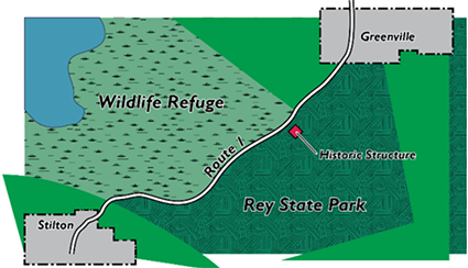
Figure 1. Project area map
ENVIRONMENTAL CONTEXT
Both the refuge and park are wooded areas, providing habitat to a variety of species that often pass back and forth between the two recreation areas, thriving in the protected woodlands and wetlands. The right-of-way along Route 1 is particularly narrow, limiting encroachment into the relatively undisturbed public lands. Rey State Park also contains a historic property located approximately 10 feet from the Route 1 right-of-way. State-owned woodland and wetland areas also lie along the corridor. Some of these resources are protected under Section 4(f).1
PEL STUDY OVERVIEW
In response to safety and congestion concerns in the corridor, the State DOT acknowledged the need to examine this section of Route 1 in more detail to determine possible interventions. Due to the combination of the sensitive environmental setting, complex transportation problems, and unknown information about the study area, the State DOT chose to conduct a PEL study rather than immediately initiate the National Environmental Policy Act (NEPA) process. By following the process for conducting a PEL study, the State DOT expects to achieve better project results and save time by ensuring that planning information, analyses, and decisions can be incorporated or adopted by reference during the subsequent NEPA process. Because the decision had not yet been made about which PEL authority would be preferable, the State DOT provided a public notice that the products of the PEL study may be adopted during a subsequent environmental review process.
ROUTE 1 PEL STUDY GOALS
The State DOT’s Route 1 PEL study includes the following goals, each of which is aligned with a specific objective:
- Collect Data: Collect high quality information about transportation and environmental baseline conditions, assessing the sources and defining reliable data that are viable for use in NEPA.
- Engage Stakeholders and the Public: Engage Federal, state, and local stakeholders, Indian tribal governments,2 including the public, early and throughout the PEL study.
- Prepare Adequate Documentation: Create documentation that describes outreach, data collection, analysis, and decision-making to ensure a complete record is available for subsequent project phases, including NEPA.
- Determine the potential seriousness of the impacts and the resulting level of documentation that may be required in the NEPA process and whether there is any feasible and prudent avoidance alternative to impacts to the park and wildlife refuge.3
ROUTE 1 PEL STUDY PROCESS
The State DOT appointed a study project manager to lead the PEL study. Monthly integration review team (IRT) meetings were held with the Metropolitan Planning Organization (MPO) and local, state, and Federal partners to discuss the project and engage stakeholder representatives. The IRT formed a technical advisory committee (TAC) to assist the State DOT with conducting the PEL study and provide monthly reports to the IRT to keep all relevant parties informed throughout the process. The TAC included planning and environmental subject matter experts from the Federal Highway Administration (FHWA) division office, as well as representatives from the resource, regulatory, and land-management agencies. The TAC worked with the PEL study project managers to achieve the PEL study’s four goals: (1) Data; (2) Engagement; (3) Documentation; and (4) Potential impacts and Section 4(f) avoidance alternatives.
ROUTE 1 PEL STUDY CONTENTS
The PEL study included the following:
- Data: The study used state traffic count data, regional traffic forecasts, and visitation data from the wildlife refuge and Rey State Park. Collision records collected from state and local police forces provided additional details about safety conditions in the study area. Wildlife, habitat, historic resources, and other environmental data came from the StateMAP GIS database, the state’s agreed upon source for statewide geospatial data, which incorporates data from state, local, and Federal agencies. The TAC also reviewed all relevant state and local planning documents pertaining to the PEL study area.
- Engagement: The TAC engaged resource and regulatory agencies with special expertise or jurisdiction and held regular meetings regarding the PEL study, including workshops to conduct analyses. Meetings and workshops were open to the public and, throughout the process, the TAC published updates to a study website and an e-mail listserv.
- Documentation: The PEL study team documented each component of the PEL study in memoranda or separate reports. All methodologies, data, sources, analyses, meeting agendas and minutes, workshop proceedings, and results were compiled and formatted as study appendices.
POSSIBLE OUTCOME #1
Route 1 PEL study under 23 U.S.C. 168
Moving forward into the project study during planning, the State DOT has used the PEL study to identify sensitive resources in the project study area before starting the environmental review process. The planning study objectives were to identify the sensitive resource areas that should be avoided, analyze the development pressure along the corridor, and study the potential for indirect or cumulative impacts to the resources that could result from the transportation improvements. The intent was to adopt the avoidance information produced from the corridor study directly in the environmental review. The land management agencies and the resource agencies have actively engaged with the project because of the sensitive nature of the resources, and the PEL study team has felt that the conditions required by 23 U.S.C. 168 were achievable.
The PEL study team developed the study as part of the transportation planning process,4 with the TAC ensuring that the team developed the study in accordance with the conditions for adoption or incorporation by reference of its products in the environmental review process. Importantly, the team identified the most current data available and reviewed it for rationality and reliability, confirming the data was based on scientifically acceptable methodologies. The TAC documented the collection and use of the data to facilitate its use in subsequent environmental studies and to support any decisions made in the study that would inform the environmental review. The active coordination with resource and regulatory agencies has been critical to ensure that information gathered and decisions made during the study could be adopted or incorporated by reference into the environmental review.
Once NEPA began, the lead agency determined that the conditions in 23 U.S.C. 168 had been satisfied, that the information from the transportation planning process could stand alone, without further content, and was of NEPA quality. The cooperating agencies concurred in this determination. The lead agency made all analyses or studies available to the public and participating agencies for review and comment during the NEPA scoping process, and the documents were reasonably available during comment periods. The lead agency also gave notice that it intended to adopt, or incorporate by reference, the planning information and decisions in the NEPA document.
POSSIBLE OUTCOME #2
PEL study under 23 CFR 450.212(a)-(c) and 450.318(a)-(d), with the Appendix A of 23 CFR Part 450 guidance
Moving forward into the PEL study during planning, the agencies have used 23 CFR 450.212(a)-(c) and 450.318(a)-(d), and the guidance in Appendix A of 23 CFR Part 450, because consistent involvement by the resource agencies was uncertain, and the team believed the regulatory conditions were more achievable and would enable the use of partial or entire documents produced from the PEL study to inform NEPA. The PEL study team conducted studies on the corridor involving com-munity groups and local elected officials representing people who walk and ride bicycles along the popular recreational corridor. The team also coordinated with the wildlife refuge and the state park to conduct additional studies and some surveys to update the information about sensitive resources along the corridor and shared that information with the public during the many project workshops.
Following safety and congestion improvements on a parallel corridor that resulted in alleviating some of the traffic challenges on Route 1, the PEL study schedule changed to allow time to better assess how the adjacent improvements might inform the improvements along the study corridor. Due to the improvements on the adjacent corridor, vehicular traffic on Route 1 decreased somewhat and non-motorized recreational traffic increased, making improvements to accommodate those users a priority.
There were many factors that contributed to the success of the PEL study including:
- The active and frequent engagement of the resource agencies;
- The public involvement plan was flexible and easily accommodated the revised schedule; and
- Documentation of the safety, congestion, and multimodal studies were maintained.
Once NEPA began, the lead agency determined that the information incorporated from the transportation planning process could not completely stand alone, that it did not contain all of the information or analysis required by NEPA, and that it would need to be supplemented by other information contained in the NEPA document. All analyses or studies were made available to the public and participating agencies during the NEPA scoping process, and were reasonably available during comment periods.
_______________________________
DISCLAIMER: Except for the statutes and regulations cited, the contents of this document do not have the force and effect of law and are not meant to bind the public in any way. The document is intended only to provide clarity to the public regarding existing requirements under the law or agency policies.

