FHWA-HEP-16-005
Printer-friendly PDF →
FHWA Eco-Logical Case Studies Series
Example of Implementing Eco-Logical Steps 1-4
Agency: Charlottesville-Albemarle Metropolitan Planning Organization
Eco-Logical is an approach designed to help transportation, resource, and regulatory agencies integrate their infrastructure development and conservation planning processes and arrive at a joint set of environmental priorities. It organizes current methods to address natural resource identification, avoidance, minimization, and mitigation into a systematic, nine-step process that starts at the beginning of the transportation planning process and concludes with establishing programmatic approaches to recurring natural resource issues that are implemented at the project level. This is one case study in a series that highlights how transportation agencies around the country are implementing the nine steps of Eco-Logical.
The Eco-Logical Approach
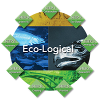
Eco-Logical’s nine steps organize how agencies can partner and integrate plans to identify environmental priority areas and ecological considerations in project planning and delivery. Agencies can apply the steps in order or independently of each other.
The steps, including steps 1-4 featured in this case study, are:
Step 1:
Build and strengthen collaborative partnerships and vision
Step 2:
Characterize resource status and integrate natural environment plans
Step 3:
Step 4:
Assess effects on conservation objectives
Step 5:
Establish and prioritize ecological actions
Step 6:
Develop crediting system
Step 7:
Develop programmatic consultation, biological opinion, or permit
Step 8:
Implement agreements, adaptive management and delivery projects
Step 9:
Update REF and plan
This case study demonstrates how the Charlottesville Albemarle Metropolitan Planning Organization (CA-MPO) and its parent organization, the Thomas Jefferson Planning District Commission (TJPDC), implemented steps 1-4 of the nine-step Eco-Logical approach in the Charlottesville, Virginia area. TJPDC first developed a Regional Ecosystem Framework (REF), which helped in screening potential transportation projects and identifying mitigation opportunities. CA-MPO then used the Eco-Logical approach to engage stakeholders in the evaluation of project alternatives for the Free Bridge Area Congestion Relief Project, a project to alleviate congestion issues on the US-250 crossing of the Rivanna River.
As part of their processes, CA-MPO and TJPDC:
- Engaged 33 stakeholders in a facilitated stakeholder engagement process to build consensus for the Free Bridge Area Congestion Relief Project
[Step 1];
- Finalized a Green Infrastructure Study that compiled existing natural resource data from 12 data layers [Step 2];
- Created a REF for the 6-locality region [Step 3]; and
- Developed tools that use the REF to assess the impacts of transportation projects on natural resources [Step 4].
CA-MPO’s 7-year effort was performed, in part, under its:
- FHWA Eco-Logical grant awarded to TJPDC in 2008
|
$77,833 |
|
|
$77,898 |
- Second Strategic Highway Research Program (SHRP2) Implementation Assistance Program (IAP) funding awarded to CA-MPO in 2013
|
$250,000 |
|
|
$405,731 |
Facts and Figures
CA-MPO is a component within TJPDC, focusing primarily on transportation planning within a specific area of the TJPDC planning district. TJPDC serves a larger jurisdiction and has a broader range of responsibilities.
Thomas Jefferson Planning District Commission (TJPDC)
- Serves 5 counties (Albemarle, Fluvanna, Greene, Louisa, and Nelson) and the City of Charlottesville
- Population served (2010): 191,237
- Full-Time Employees (FTE): 11
- Key responsibilities: community planning, housing and human services, solid waste, regional sustainability, transportation and environmental planning
Charlottesville Albemarle Metropolitan Planning Organization (CA-MPO)
- Organized as a component of TJPDC
- Serves the City of Charlottesville and urbanized area of Albemarle County
- Population served (2010): 113,074
- FTE: 2
- Key responsibilities: transportation planning
CA-MPO’s Challenge
Like many regions around the country, the Charlottesville, Virginia area faces challenges balancing rapid development with the preservation of natural resources. TJPCD and CA-MPO had the following goals for their regional transportation planning processes:
- Support transportation needs while preserving natural resources and quality of life. Between 2000 and 2010, the population served by TJPDC grew by 18 percent. This rapid population growth heightened the need for new transportation infrastructure to support mobility and economic development. However, proposed transportation projects, including the Free Bridge Congestion Relief Project, had the potential to negatively impact the region’s ecological resources. TJPDC and CA-MPO needed a way to accommodate the transportation needs of the region’s residents while protecting natural resources.
- Improve stakeholder engagement in the transportation planning process. Some stakeholders in the environmental community had lost confidence in the transportation planning process as a result of years of disconnected planning processes. In particular, a previous attempt to develop transportation solutions for the Free Bridge Area failed to address stakeholder concerns and left many citizens and advocacy groups skeptical and frustrated. TJPDC and CA-MPO sought to bring together a diverse stakeholder community and identify transportation project alternatives that met the region’s goals for mobility, economic development, and environmental conservation.
Implementing Eco-Logical
To address these regional challenges, TJPDC and CA-MPO applied the Eco-Logical approach through two major efforts:
- REF Development.: In 2008, TJPDC received funding under the FHWA Eco-Logical Grant Program to develop a Green Infrastructure Study that connected existing transportation, development, and natural resource plans in the planning district. Using the results of the Green Infrastructure Study, TJPDC created a REF, a map that provides a holistic picture of the region’s ecological resources. Building from the REF, TJPCD created an Integrated Regional Map that visualizes the locations of planned and proposed transportation projects in relation to high-value natural areas.
- Free Bridge Area Congestion Relief Project. As a SHRP2 Implementing Eco-Logical IAP recipient, CA-MPO is using the REF produced during TJPDC’s Eco-Logical grant project to establish priorities and screen alternatives for the Free Bridge Area Congestion Relief Project, which will develop capacity-building improvements on the US-250 Crossing of the Rivanna River. As part of this project, CA-MPO developed a facilitated stakeholder process to identify and evaluate project alternatives. Using the previously-developed REF, CA-MPO established a weighted ranking system for evaluating the impacts of the proposed alternatives on ecosystem and recreation resources connected to the surrounding Rivanna River watershed.

The timeline shows major deliverables and activities in TJPDC and CA-MPO’s implementation of the Eco-Logical approach.
Step 1: Build and Strengthen Collaborative Partnerships and Vision
As the timeline above illustrates, TJPDC and CA-MPO have emphasized partnerships and stakeholder engagement throughout their implementation of Eco-Logical. The Eco-Logical process has allowed TJPDC and CA-MPO to bring diverse stakeholder groups together to identify a regional vision for holistically addressing transportation needs and environmental priorities.
Initial Outreach
As part of its Green Infrastructure Study, TJPDC worked with stakeholders—including local governments, State agencies, and environmental non-profit organizations—to build consensus around the region’s ecological priorities for conservation and mitigation. From the outset, one of TJPDC’s goals was to create a REF that would be useful for other organizations engaged in mitigation or conservation work. TJPDC used the following techniques to ensure that the REF reflected a shared regional vision of conservation priorities:
- Technical advisory committees. Two technical advisory groups, the Green Infrastructure Study Technical Committee and the REF Advisory Committee, guided development of TJPDC’s Eco-Logical products. Each committee included technical experts and representatives from resource agencies, local governments, and non-profit organizations.
- Face-to-face consultations with TJPDC’s six member governments. In the first year of its Eco-Logical grant, TJPDC met in-person with its member governments (5 counties and the City of Charlottesville) and gained support from all of them for its Green Infrastructure Study.
- Stakeholder Outreach. Following the completion of the REF in 2011, TJPDC held meetings with planning, transportation, and environmental staff in each of its member governments; conservation non-profit organizations; and soil and water conservation districts. At each meeting, TJPDC informed stakeholders about the project findings, promoted the REF as a tool for regional conservation and mitigation planning, and solicited feedback for refining the REF. This outreach succeeded in increasing the number of users of the REF dataset and building familiarity with the Eco-Logical approach.
Key Accomplishments for Step 1
Green Infrastructure Study and REF
- Buy-in from all 6 member governments
- 2 technical advisory committees
- 14 meetings of the Green Infrastructure Study
Technical Committee
Free Bridge Congestion Relief Project
- 33-member stakeholder committee
- 7 facilitated stakeholder meetings (January 2014-November 2014)
- 1 public open house
According to TJPDC, these stakeholder engagement activities improved its relationships with environmental staff from the City of Charlottesville, planners, resource agencies, conservation districts, and State agencies. By working closely with stakeholders from the beginning, TJPDC ensured that its work products reflected shared regional priorities and laid the framework for applying the Eco-Logical approach to specific project areas.
Free Bridge Congestion Relief Project
For its SHRP2 IAP project, CA-MPO applied Step 1 to a particular project: the Free Bridge Congestion Relief Project. Starting in 2013, CA-MPO used a stakeholder committee to identify and screen project alternatives. The process allowed CA-MPO to encourage stakeholder buy-in and continue partnerships started during the original TJPDC Eco-Logical grant project. CA-MPO used an independent facilitator throughout the process, which added a neutral voice and helped CA-MPO to resolve past concerns about the project.
The 33-member stakeholder committee included elected officials and staff from the City of Charlottesville and Albemarle County, non-governmental organizations, business owners, and members of the public.
Step 2: Characterize Resource Status and Integrate Natural Environmental Plans
In 2008 and 2009, TJPDC compiled and analyzed existing data on habitat, aquatic resources, recreation areas, greenways, and other environmental resources to produce a Green Infrastructure Study that summarized the region’s natural resources. Working with the Green Infrastructure Study Technical Committee, TJPDC identified key “cornerstone layers” that were most important to a healthy, interconnected regional ecosystem. These cornerstone layers were:
Key Accomplishments for Step 2
- 10 data layers catalogued
- 12 data layers incorporated into the Green Infrastructure Study
- Critical habitat from the Virginia Conservation Lands Needs Assessment Habitat Cores and Corridors and the Albemarle Biodiversity Work Group’s Important Sites
- Steep slopes (25% grade or more)
- Major streams
- Existing trails and adopted greenway/trail plans
- Public lands and lands under permanent conservation easement
During development of the Green Infrastructure Study, TJPDC staff met with representatives of local jurisdictions to review draft maps, identify potential inaccuracies, and adjust the maps to incorporate local knowledge and priorities.
The Green Infrastructure Study, published in 2009, includes final maps of the cornerstone layers and identifies environmental areas of opportunity for each county in the planning district.
Step 3: Create a Regional Ecosystem Framework (REF)
Key Accomplishments for Step 3
- REF incorporates 10 data layers on key natural resources
- 5 organizations (2 Federal agencies, 2 State agencies, and 1 non-profit) maintain the datasets used in the REF
- REF covers 5 counties encompassing 2,155 square miles at a resolution of 30 meters
- Integrated Regional Map overlays 3 long-range transportation plans with REF and scores projects by environmental impact
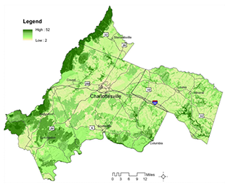
TJPDC’s REF provides a holistic overview of important natural resources in the five-county region. Darker greens indicate areas of higher ecological value. (Courtesy of TJPDC)
Building on the results of Green Infrastructure Study, TJPDC developed a REF in the form of a Geographic Information Systems (GIS) layer that scores all areas in the region by natural resource value.
To create the REF, TJPDC worked with a new technical advisory committee1 to weight and combine 10 of the data layers identified in the Green Infrastructure Study, including data on:
- Threatened and endangered species from Virginia Department of Game & Inland Fisheries (DGIF)
- Priority habitat from Virginia Department of Conservation & Recreation (DCR), National Audubon Society, and DGIF
- Wetlands and streams from U.S. Fish & Wildlife Service, U.S. Geologic Survey, DCR, and DGIF
The resulting REF is a single map that provides a holistic picture of the region’s ecological resources.2 Every 30-meter pixel in the region is scored based on the concentration of natural resources. The REF provides a tool for landscape-level assessments of natural resources, prioritization of mitigation projects, and early screening of transportation projects.
The first version of the REF was finalized in 2011. TJPDC shares the REF dataset upon request, free of charge. TJPCD plans to post the REF dataset on its publicly available website in late 2015.
Following development of the REF, TJPDC created a map to help transportation agencies and local governments assess the environmental effects of planned transportation projects. The Integrated Regional Map overlays projects from the region’s three long-range transportation plans (Virginia Long-Range Multimodal Transportation Plan, United Jefferson Area Mobility Plan, and the Rural Long-Range Transportation Plan) with the REF and scores projects based on environmental impact.
Step 4: Assess Effects on Conservation Objectives
Since the completion of the REF in 2011, TJPDC and CA-MPO have developed maps, tools, and methodologies to identify where transportation projects may have impacts on resources mapped in the REF. TJPDC and CA-MPO use the REF to:
- Prioritize mitigation sites. Using the REF and other natural resource data, TJPDC developed methodologies for prioritizing stream and wetland mitigation opportunities. The resulting maps, finalized in 2011, identify regional mitigation priorities for streams and wetlands. TJPDC and CA-MPO frequently conduct outreach to promote use of the mitigation priority maps among conservation organizations, private developers, Virginia Department of Transportation (VDOT), and other entities that use mitigation approaches.
- Incorporate the REF into development of alignments. TJPDC created a Least Environmental Cost GIS tool to facilitate development of road alignment alternatives that minimize environmental impact. The Least Environmental Cost tool uses the REF to calculate the least environmentally damaging path between two points. Planners can add other data layers like land use, building footprints, and slope to more accurately represent real-world constraints. TJPDC and CA-MPO use the tool to identify and screen alignment alternatives.
- Inform development of the Long-Range Transportation Plan (LRTP). During updates for the region’s most recent LRTP, adopted in 2014, TJPDC and CA-MPO used data from the REF to screen transportation projects for their effects on conservation objectives and compare the environmental impacts of growth scenarios. The REF was used as a key quantitative performance measure in evaluating potential transportation projects for inclusion in the LRTP.
Key Accomplishments for Step 4
- 2 methodologies for prioritizing mitigation sites: one for wetlands and one for streams
- Least Environmental Cost GIS tool generates alignments that minimize environmental impacts
- REF used to compare the environmental impacts of project alternatives for the Free Bridge Area Congestion Relief Project
Moving forward, one of the major uses of the REF will be for evaluating the environmental impacts of project alternatives at the planning phase. For its SHRP2 IAP project, CA-MPO piloted the use of its REF in evaluating proposed alternatives at the planning phase of project development for the Free Bridge Area Congestion Relief Project. The Free Bridge, the US-250 crossing of the Rivanna River, is a critical local and regional link that faces high levels of congestion. CA-MPO incorporated the REF into a weighted ranking system to assess and evaluate the impacts of seven proposed project alternatives. Each project alternative was assigned a score that quantified its environmental impact.
Over an 18-month period, a stakeholder group analyzed the project alternatives based on congestion relief, environmental impact, and feasibility. At the conclusion of the process, the stakeholder group recommended two alternatives for further analysis; both recommended alternatives have low ecological impacts as measured by the REF. As a result of the stakeholder group’s recommendation, both project alternatives were added to the Visioning List for CA-MPO’s LRTP. (The Visioning List is a document that CA-MPO uses to identify important regional projects for either future inclusion on its constrained project list or to prioritize for State transportation funding.)
Key Results & Findings
Using the Eco-Logical approach, TJPDC and CA-MPO developed a REF to consider impacts on natural and cultural resources and analyze the overall impacts of future development.
“We were able to successfully use the Eco-Logical approach to restore confidence in the transportation planning process and, at the same time, mend old wounds that had prevented productive dialog in the past.”
—CA-MPO Staff
TJPDC and CA-MPO applied the Eco-Logical approach to the Free Bridge Area Congestion Relief Project to strengthen their ability to advance projects in a study area that had been characterized by high levels of stakeholder mistrust and opposition. As a result of using the Eco-Logical approach, CA-MPO rebuilt stakeholder trust in the transportation planning process and developed consensus on two transportation alternatives at the planning phase to advance for further study.
Key results from the TJPDC and CA-MPO’s implementation of the Eco-Logical approach include:
- Completion of a REF that covers the 5-county region at a 30-meter resolution.
- Completion of an Integrated Regional Map that overlays the REF with the region’s LRTPs to identify transportation projects anticipated to have high environmental impacts.
- Resolution of long-standing stakeholder concerns around the Free Bridge Area Congestion Relief Project.
- Stakeholder consensus to advance two alternatives for the Free Bridge Area Congestion Relief Project for further study, based in part upon the alternatives’ low ecological impacts.
Lessons Learned
Key lessons learned from TJPDC and CA-MPO’s implementation of the Eco-Logical process include:
- Build on existing datasets. To develop its REF, TJPDC did not start from scratch but instead consolidated information from 10 existing datasets maintained by 5 organizations. This allowed TJPDC to move forward with development of the REF despite the agency’s small staff size. Existing datasets compiled by natural resource agencies like Virginia DCR and conservation organizations like the Audubon Society provided the foundation for the region’s Green Infrastructure Study and REF.
- Use a neutral facilitator. An independent facilitator who is trusted by the community can help make the stakeholder engagement process more legitimate and productive. CA-MPO reported that using a neutral facilitator for the Free Bridge Congestion Relief Project helped resolve long-standing stakeholder concerns about the process.
- Educate stakeholders about Eco-Logical. TJPDC and CA-MPO initially faced resistance from stakeholders who feared that the Eco-Logical process would undermine existing environmental regulations. TJPDC and CA-MPO used education and outreach to emphasize that the Eco-Logical approach complements existing environmental laws. Educational materials, like a handout explaining Eco-Logical and the REF tool, helped CA-MPO alleviate fears among stakeholders and create new partnerships.
Next Steps
CA-MPO plans to integrate Eco-Logical into everyday practices in a variety of ways. Planned next steps include:
“We continue to look for new and innovative ways to use the REF tool in the projects that we do for both CA-MPO and the Regional Planning District.”
—CA-MPO Staff
- Updating the CA-MPO website to include the REF tool, user guide, and instructional presentation, to help promote use of the REF by local governments and non-profit organizations;
- Developing a training module on Eco-Logical for staff at VDOT, metropolitan planning organizations, and local jurisdictions;
- Coordinating with VDOT to formalize agency’s endorsement of Eco-Logical and work with VDOT contacts and support staff to ensure that the Eco-Logical REF tool is used during the development of transportation project alternatives within CA-MPO; and
- Preparing a report that documents how the Eco-Logical approach and REF satisfy Virginia’s statewide requirement for transportation agencies to use environmental performance measures.
For More Information
Contacts
Wood Hudson
Senior Environmental Planner
Thomas Jefferson Planning District Commission
(434) 979-7310 x320
WHudson@tjpdc.org
David Williams
Environmental Protection Specialist
FHWA Office of Project Development and Environmental Review
(202) 366-4074
David.Williams@dot.gov
Resources

