FHWA-HEP-15-050
Printer-friendly PDF →
FHWA Eco-Logical Case Studies Series
Example of Implementing Eco-Logical Steps 7-9
Agency: Colorado Department of Transportation
Eco-Logical is an approach designed to help transportation, resource, and regulatory agencies integrate their infrastructure development and conservation planning processes and arrive at a joint set of environmental priorities. It organizes current methods to address natural resource identification, avoidance, minimization, and mitigation into a systematic, nine-step process that starts at the beginning of the transportation planning process and concludes with establishing programmatic approaches to recurring natural resource issues that are implemented at the project level. This is one case study in a series that highlights how transportation agencies around the country are implementing the nine steps of Eco-Logical.
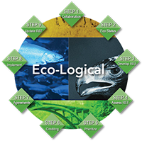
The Eco-Logical Approach
Eco-Logical’s nine steps organize how agencies can partner and integrate plans to identify environmental priority areas and ecological considerations in project planning and delivery. Agencies can apply the steps in order or independently of each other.
The steps, including steps 7-9 featured in this case study, are:
Step 1:
Build and strengthen collaborative partnerships and vision
Step 2:
Characterize resource status and integrate natural environment plans
Step 3:
Step 4:
Assess effects on conservation objectives
Step 5:
Establish and prioritize ecological actions
Step 6:
Develop crediting system
Step 7:
Develop programmatic consultation, biological opinion, or permit
Step 8:
Implement agreements, adaptive management and delivery projects
Step 9:
Update REF and plan
This case study demonstrates how the Colorado Department of Transportation (CDOT) implemented steps 7-9 of the nine-step Eco-Logical approach. CDOT used the Eco-Logical approach to guide mitigation projects and wildlife connectivity along the 144-mile Interstate 70 (I-70) Mountain Corridor in Colorado, a segment of the only east-west interstate that extends across all of Colorado.
As part of its process, CDOT:
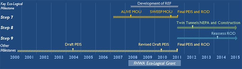
- Developed a project-level Regional Ecosystem Framework (REF) over approximately 3 years;
- Finalized a Programmatic Environmental Impact Statement (PEIS) using the REF [Step 7];
- Established two Memoranda of Understanding (MOUs) with its partners [Step 8]: 1) A Landscape Level Inventory of Ecosystem Components (ALIVE) MOU, and 2) Stream and Wetland Ecological Enhancement Program (SWEEP) MOU; and
- Continues to revisit the PEIS and related materials regularly for any needed updates [Step 9].
CDOT’s 3-year effort was performed, in part, under its:
- FHWA Eco-Logical grant awarded in 2007
|
$152,500 |
|
|
$208,593 |
|
|
$361,093 |
While CDOT had long focused on the I-70 Mountain Corridor, the Eco-Logical grant project, spanning from 2008 through 2011, helped the agency formalize its commitment. It also facilitated the implementation of the PEIS to a specific corridor project, the Twin Tunnels.

Image courtesy of CDOT
Facts and Figures
- The I-70 Mountain Corridor stretches 144 miles, from metro Denver to Glenwood Springs.
- The Corridor is part of the only east-west interstate that extends across all of Colorado.
- The Corridor passes through 5 counties and directly serves more than 20 communities.
- Freight traffic relies on the Corridor for east-west travel as no alternate routes exist. Heavy vehicles represent about 10 percent of traffic.
- Tourism is the second largest industry in Colorado, second only to agriculture. I-70 is the primary corridor for connecting the State’s metropolitan areas to recreational wilderness tourism sites. Of the $10 billion generated in the State by tourism each year, $3 billion of this comes from the resort communities served by I-70.
CDOT’s Challenge
CDOT faced the challenge of improving mobility and safety on the I-70 Mountain Corridor, while improving habitat connectivity and watershed quality and respecting community values. CDOT had the following goals for the Corridor:
- Safe Travel: Existing and projected travel demands often exceed the design capacity of the facility, resulting in severe congestion and accidents. Average annual daily traffic counts range from 14,000 to 66,000. Contributing factors include mountainous geometrics, weather conditions, and vehicle-wildlife conflicts.
- Reliable Travel: This substantial congestion has a negative impact on the local and statewide economy; decreases mobility, including for tourist and freight traffic; and compromises the ability of emergency service providers to respond promptly to emergencies. Congestion along the I-70 Mountain Corridor accounts for $839 million in lost revenue each year.
- Habitat Connectivity: The Corridor bisects major wildlife migration corridors, posing a barrier to north-south wildlife movement and resulting in approximately 250 animal-vehicle collisions each year. In developing the ALIVE MOU, an interagency committee identified 13 zones where the I-70 Mountain Corridor interferes with wildlife migration for species including elk, mule deer, bighorn sheep, and Canada lynx. The area is also home to several endangered species, such as the greenback cutthroat trout.
- Watershed Health: The Corridor crosses headwaters on both sides of the Continental Divide, making creek health for downstream users and aquatic species a priority. Most of the Corridor lacked modern stormwater treatment infrastructure.
One priority river is Clear Creek, a tributary of the South Platte River that I-70 follows for 30 miles through the Clear Creek Canyon. Due to the area’s long mining history, parts of Clear Creek remain degraded and require environmental remediation.
CDOT initiated a PEIS in 2000 to address these corridor challenges as a way to save time and resources and develop a cohesive long-term vision. As public and agency feedback grew, in 2008, CDOT applied the Eco-Logical approach to work through these issues with the active stakeholders in the corridor, including the Colorado Parks and Wildlife (CPW), Bureau of Land Management (BLM), U.S. Forest Service (USFS), and U.S. Fish and Wildlife Service (USFWS). CDOT completed the PEIS and accompanying Record of Decision (ROD) in 2011.
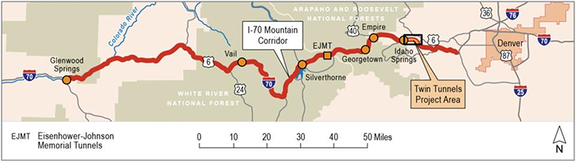
The I-70 Mountain Corridor connects metro Denver to Glenwood Springs. Image courtesy of CDOT
Implementing Eco-Logical
In 2007, FHWA established its Eco-Logical Grant Program and awarded funding to CDOT to test an ecosystem approach for the I-70 Mountain Corridor. CDOT used many of the early steps of Eco-Logical to achieve later steps of the approach. The grant project included the development of a REF—a tool to help CDOT and its partners integrate conservation priorities, data, and plans with the transportation planning process. The REF, following the Eco-Logical approach, is the output of mapping and prioritizing natural resources with existing transportation and land use plans using a Geographic Information Systems (GIS) database. The project also complemented CDOT’s efforts to finalize the PEIS using a collaborative, context-sensitive solutions (CSS) process.
As part of CDOT’s I-70 Mountain Corridor PEIS development (initiated in 2000 under the National Environmental Policy Act [NEPA]), CDOT convened two interagency groups, whose work set the stage for CDOT’s Eco-Logical activities:
- A Landscape Level Inventory of Valued Ecosystem Components (ALIVE) to designate key wildlife habitat and guide mitigation strategies for the PEIS. The ALIVE committee identified 13 priority connectivity zones for wildlife and aquatic crossings along the corridor, known as Linkage Interference Zones (LIZs). These LIZs became the basis for CDOT’s later work under the FHWA Eco-Logical Grant Program.
- Stream and Wetland Ecological Enhancement Program (SWEEP) to focus on the corridor’s water resources. The SWEEP committee collected data on past corridor activities and future growth projections to predict potential water quality impacts and inventory issues relating to stream and wetland conditions. The committee worked closely with its ALIVE counterparts to coordinate actions and resource mapping.
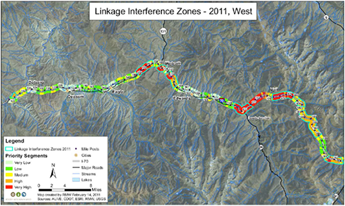
The CDOT Eco-Logical grant project included updating the original 13 LIZs to add 4 new LIZs, resulting in a total of 17 LIZs, such as the one shown above. Image courtesy of CDOT
Working with the ALIVE and SWEEP committees, CDOT developed the REF by incorporating wildlife-habitat and crossing data into a GIS database. CDOT staff used the database to review and update the original 13 LIZs, resulting in 17 LIZs across 51 miles of the corridor. CDOT also identified priority road-stream crossing locations for fish passage, particularly along the corridor’s primary water resources: Clear Creek, the Blue River, and the Eagle/Colorado Rivers.
Guided by the REF and the LIZs, CDOT:
- Fostered a shared understanding among the ALIVE and SWEEP committees of wildlife and aquatic movement and potential impacts to natural resources along the corridor.
- Developed recommendations for mitigating wildlife crossing conflicts, such as fencing and land conservation, in specific locations within the LIZs, which would later guide recommendations in the PEIS.
- Created ALIVE and SWEEP implementation matrices that identify step-by-step considerations for mitigating impacts to wildlife and aquatic resources during each phase of project delivery.
- Prepared a CSS guidance manual to share best practices for minimizing connectivity impacts along the entire I-70 network.
Step 7: Develop Programmatic Consultation, Opinion, or Permit
Building Partnerships
CDOT has engaged many partners through its ALIVE and SWEEP committees. Partners include:
ALIVE
- Local: Clear Creek County; Town of Georgetown; Town of Vail
- State: CDOT; CPW
- Federal: BLM; FHWA; USFS; USFWS
- Private Sector: CH2M HILL; ECO-resolutions, LLC; Pat Noyes & Associates
- Non-Profit: Colorado Watershed Assembly; Rocky Mountain Wild
SWEEP
- Local: Clear Creek County
- State: CDOT; CPW
- Federal: BLM; FHWA; USFS; USFWS
- Watershed Associations: Clear Creek Watershed Foundation; Upper Clear Creek Watershed Association; Eagle River Watershed Council
- Special Interest: Colorado Trout Unlimited
CDOT established two formal agreements with its partners that provide maximum assurance that transportation projects will be built in accordance with set ecological priorities. These agreements recognized CDOT’s commitment and confirmed its conservation activities and investments would be sufficient. CDOT also incorporated the agreements into the PEIS and ROD to establish guidelines for future project development, thus fulfilling the purpose of Step 7.
Establishing the ALIVE and SWEEP MOUs
In developing the PEIS, CDOT and its partners agreed to formalize their partnerships through two primary MOUs specifically for the I-70 Mountain Corridor:
- ALIVE MOU – Documents a commitment to decrease animal-vehicle collisions and increase habitat connectivity.
- SWEEP MOU – Focuses on improving and protecting stream and wetland ecology.
Elements of the MOUs include:
- Agreed-upon resource management roles and methods. Both MOUs identify specific roles for each signatory party, from leading the primary effort to initiate the ALIVE and SWEEP programs (CDOT) to considering the programs’ recommendations when reviewing NEPA documents (USFS, BLM). The MOUs also detail agreed-upon conservation strategies and mitigation measures such as new or repairs to existing wildlife fencing to expedite environmental reviews for transportation projects under the PEIS.
- Outcome-based performance standards. Under the MOUs, partners committed to using the REF and implementation matrices to guide future projects in the corridor. The matrices provide step-by-step checklists of items for CDOT and its partners to consider when transitioning from the environmental review process through to project implementation. For example, the SWEEP matrix lists objectives, inputs, considerations, and outcomes for each issue of concern identified (e.g., sediment management).
Key Accomplishments for Step 7
- Establishment of ALIVE and SWEEP MOUs
- Coordination with ALIVE and SWEEP committees, consisting of local, State, Federal, private, and non-profit partners
With the MOUs in place, CDOT then focused on finalizing its PEIS for the entire I-70 Mountain Corridor. The PEIS, a NEPA Tier 1 document, functions as a planning/programmatic agreement. Among other items, the PEIS establishes a long-term Corridor vision, identifies a program of improvements, considers the range and type of impacts, commits to mitigation strategies, and directs the NEPA Tier 2 project-level process. Both the MOUs and PEIS helped direct the design, impact analysis, and mitigation strategies to be employed in the Twin Tunnels project, the first constructed project along the I-70 Mountain Corridor to follow the PEIS.
Step 8: Implement Agreements, Adaptive Management, and Deliver Projects
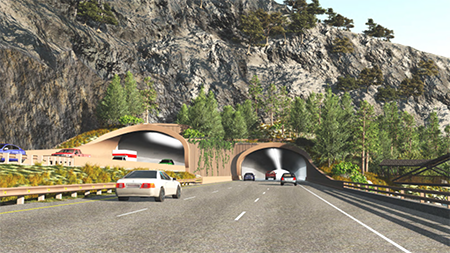
The Twin Tunnels. Image courtesy of CDOT
“Both MOUs were signed and in place before the ROD. The investment that all of our partners put upfront in the MOUs has really paid dividends. For both MOUs, the working groups developed recommendations and mitigation approaches that ultimately went into the ROD.”
— CDOT Staff
CDOT developed the Twin Tunnels project based on the PEIS. The I-70 Mountain Corridor PEIS presented a framework for subsequent Tier 2 NEPA processes to be completed so that the specific projects are consistent with the Tier 1 decision and developed and implemented accordingly. The Twin Tunnels Environmental Assessment (EA) is a Tier 2 NEPA document that links its corridor planning process to the project-level implementation phase. CDOT conducted the EA following the agreements and processes outlined in the PEIS, including the:
- I-70 Mountain Corridor CSS process;
- SWEEP and ALIVE MOUs; and
- Related Section 106 programmatic agreement, and other mitigation strategies.
CDOT performed its analysis of alternatives for avoidance and minimization for the Twin Tunnel project in accordance with commitments, agreements, and protocols established in the PEIS (Step 7). The project design included design standards to minimize impact. CDOT incorporated many of these standards into the EA, as well as conditions for regulatory authorizations and permits to comply with the Clean Water Act. CDOT also has a system for recording all mitigation requirements by project, actions taken, and monitoring completion that is available to the regulatory agencies for verification.
Delivering the I-70 Twin Tunnels Project
Key Accomplishments for Step 8
- Completion of Twin Tunnels EA
- Use of implementation matrices to track more than 100 commitments from the environmental review process through to project implementation
In July 2012, the Twin Tunnels Environmental Assessment (EA) became the first Tier 2 NEPA process to follow the PEIS. The project focused on capacity and safety improvements; it widened the eastbound tunnel for four miles, straightened curves, and constructed retaining walls and sediment basins. CDOT held a series of stakeholder workshops to develop design concepts and used the REF and LIZ data to guide site-specific recommendations such as spill containment features to reduce roadway runoff into Clear Creek and directional lighting to decrease impacts to wildlife. Because one of the LIZs was within the project area, CDOT also reconfigured plans for a bridge to make its wildlife underpass more attractive for large animals.
Throughout the Twin Tunnels project, CDOT used the ALIVE and SWEEP implementation matrices as checklists to track commitments made in the environmental review and design processes through to implementation. Having the matrices in place helped CDOT manage the more than 100 commitments from NEPA and permitting requirements and brought assurances to partner agencies and local stakeholders of continuity between the planning and project delivery life cycles.
Step 9: Update REF and Plans
In keeping with the Eco-Logical approach, CDOT recognizes that ecological conditions and agency priorities often change over time. Priority habitat areas and resource locations may shift, and mitigation strategies may require updates. This attention to regular updates of products and data relates to Step 9.
Key Accomplishments for Step 9
- Establishment of CDOT I-70 CSS website
- Reassessment of ROD every two years
To ensure its data and strategies stay current, CDOT regularly revisits the ALIVE and SWEEP implementation matrices to ensure their accuracy. In addition, CDOT and its partners reassess the assumptions and status of the ROD every two years, with the last reassessment done in April 2015. In 2020, CDOT will conduct a formal reassessment of the ROD and the process and improvements addressed in the preferred alternative.
To maintain its knowledge base, in 2010, CDOT created an I-70 CSS website to post materials and share best practices relating to the I-70 Mountain Corridor, including findings and feedback from stakeholder design and visioning workshops, aesthetics guidance, and engineering design criteria. The website serves as a one-stop shop for all corridor-related products.
Key Results & Findings
CDOT expedited delivery of the Twin Tunnels project through its early coordination efforts and use of wildlife habitat and crossing data to develop an REF. The ALIVE and SWEEP MOUs established goals, expectations, and roles, which later helped the Twin Tunnels project move quickly from design to implementation. The ALIVE and SWEEP implementation matrices also provided CDOT with a clear way to track timelines and needed activities.
CDOT has found multiple benefits in using Eco-Logical approach:
- The establishment of the PEIS initiated a systematic process that CDOT can use for future projects throughout the I-70 corridor. The PEIS also allows CDOT to streamline project delivery as qualifying projects allow for a more expedited review, which can result in significant time savings in the environmental review process.
- In collaborating with partners and using input from the REF, CDOT was able to make design modifications during the Twin Tunnels project that limit impacts and result in better environmental conditions. For example, adjacent sediment basins now treat 20 percent more runoff than before the Twin Tunnel improvements occurred.
- CDOT earned trust with its stakeholders by fulfilling commitments set forth under the PEIS. Having this process in place gave stakeholders assurances that values identified in early design stages would be carried through to implementation. The PEIS also helped CDOT avoid the risk of backtracking from personnel changes over a multi-year project and provided best management practices for future projects.
- Overall, CDOT’s experiences in applying Eco-Logical to the Twin Tunnels project has resulted in improved:
- wildlife movement given a new bridge for large mammals and the retrofitting of box culverts;
- water quality due to new sediment control and spill containment facilities; and
- aesthetics, which have helped to reduce sign clutter and allow for new vegetation along the corridor.
In addition, CDOT found successes in reducing congestion and improving safety along the I-70 Mountain Corridor. CDOT estimates that corridor improvements will lower travel times by 15 percent and reduce crashes by 20-35 percent (65-80 crashes per year).
CDOT has been involved in Eco-Logical activities for more than a decade. The establishment of CDOT’s REF as well as the ALIVE and SWEEP MOUs led the way for the finalization of the PEIS and later Twin Tunnels EA.
Lessons Learned
Key lessons learned from CDOT’s implementation of the Eco-Logical approach include:
- Foster early and continued commitment from partner agencies and stakeholders.
- Use tools such as an implementation matrix to track commitments and ensure accountability and consistency from design stages to implementation.
- Demonstrate the connections between Eco-Logical and other familiar transportation terms to build understanding. For CDOT, this meant integrating Eco-Logical principles into its CSS approach.
Next Steps
The success of the Twin Tunnels project has created momentum for CDOT, both at the project and planning levels. At the project level, CDOT is applying its REF and PEIS to two other projects along the I-70 Mountain Corridor. At planning level, CDOT is starting to list wildlife crossing projects in its 2040 long-range transportation plan, building further connections between ecological considerations and the transportation planning process. CDOT and FHWA are currently planning an Eco-Logical workshop on wildlife crossings, which is proposed for fall 2015.
For More Information
Contacts
David Singer
Environmental Program Manager
I-70 Mountain Corridor Program
Colorado Department of Transportation
(720) 4970-6960
David.Singer@state.co.us
David Williams
SHRP2 Capacity Program
Implementing Eco-Logical Program Lead
FHWA Resource Center
(410) 962-2483
David.Williams@dot.gov
Resources

