Eco-Logical Grant Program Annual Report
February 26, 2010
 |
Prepared for:
Office of Project Development and Environmental Review
Federal Highway Administration
U.S. Department of Transportation |
 |
Prepared by:
Multimodal Systems Research and Analysis
John A. Volpe National Transportation Systems Center
Research and Innovative Technology Administration
U.S. Department of Transportation |
ACKNOWLEDGEMENTS
The U.S. Department of Transportation (USDOT) Volpe National Transportation Systems Center (Volpe Center), in coordination with the Federal Highway Administration (FHWA), prepared this report, which was funded by the FHWA's Office of Planning, Environment, and Realty's Surface Transportation Environment and Planning Cooperative Research Program (STEP). The project team included Haley Peckett, Carson Poe, and Julianne Schwarzer of the Volpe Center's Transportation Policy, Planning, and Organizational Excellence Division.
METHODOLOGY
The Volpe Center collected data for this report through several methods. First, Volpe Center staff conducted 30- to 60-minute telephone interviews with the grant recipients and the FHWA Agreement Officer Technical Representatives (AOTRs) over a 2-month period. The Volpe Center also reviewed grant applications and quarterly progress reports submitted in 2009; collected information from the Geographic Information System (GIS) Applications in Eco-Logical Grant Projects peer exchange held in Austin, Texas, during July of 2009; and derived information through periodic monitoring of the grant program. Then, the Volpe Center compiled and analyzed the data and synthesized them into project summaries and findings. Additionally, the Volpe Center compiled a list of presentations given by the grant recipients, which can be found in Appendix A; the list of presentations shows the diversity of where the grant recipients have showcased their projects.
TABLE OF CONTENTS
TABLE OF FIGURES
Back to top
EXECUTIVE SUMMARY
The Federal Highway Administration's (FHWA) Eco-Logical grant program currently funds 15 projects that are implementing the principles outlined in the 2006 multi-agency publication Eco-Logical: An Eco-System Approach to Developing Infrastructure Projects (Eco-Logical).
This report tracks the progress, accomplishments, challenges, and future steps of the grant recipients in the second year of the FHWA grant program from January to December 2009. It incorporates information gathered during interviews with grant recipients and FHWA Agreement Officer Technical Representatives (AOTRs), information from the Geographic Information System (GIS) Applications in Eco-Logical Grant Projects peer exchange1, and information from quarterly progress reports.
The main conclusion of this report is that all of the Eco-Logical grant recipients have made significant progress toward their goals and learned valuable lessons about implementing the Eco-Logical principles. Nearly all of the recipients plan to keep these principles central to the missions of their organizations after the grants' periods of performance expire. FHWA can continue to learn how the Eco-Logical approach can best be used in practice and implemented on a larger scale by translating the products for national distribution.
Other key findings include:
- All grant recipients reported new or strengthened relationships with governmental agencies and non-governmental organizations (NGOs). These partnerships help to integrate related plans and lay the groundwork for future collaboration.
- Many grant recipients remarked that working with FHWA staff enhanced or gave credence to their projects, while other recipients cited limited engagement or perceived a lack of support from FHWA Division Office staff.
- Some grant recipients noted that participating in the Eco-Logical grant program promoted earlier coordination of data and agencies in their planning and implementation processes.
- While some grant recipients found that the Eco-Logical approach fit naturally with practices of their organization, others faced barriers to implementing Eco-Logical, including confusion as to how Eco-Logical should fit into the existing planning process. Many grant recipients plan to formally incorporate Eco-Logical into their transportation and comprehensive plans.
- Several grant recipients encountered challenges in working with agencies and stakeholders due in part to divergent methodologies and goals for conservation and mitigation. Many of these challenges are being addressed through improved communication and outreach, while other grant recipients overcame these challenges by demonstrating the benefits of shared data.
Back to top
ACRONYMS AND ABBREVIATIONS
AOTR
CAPCOG
CDOT
CDOT
CNE
COG
EPA
FHWA
FWS
GIS
H-GAC
ICOET
LEED
LOSRC
LRTP
MARC
MPO
NCDENR
NCDOT
NCTCOG
NGO
NHA
NHDOT
NYSDOT
OCS
ODOT
OSU
PWG
REAP
REF
RPC
RPO
TCRPC
TCSWCD
TEAP
TIP
TJPDC
TRB
TxDOT
UTA
WRC |
Agreement Officer Technical Representative
Capital Area Council of Governments
Colorado Department of Transportation
Chicago Department of Transportation
Center for Native Ecosystems
Council of Governments
Environmental Protection Agency
Federal Highway Administration
U.S. Fish and Wildlife Service
Geographic Information System
Houston Galveston Area Council
International Conference on Ecology and Transportation
Leadership in Energy and Environmental Design
Land of Sky Regional Council
Long Range Transportation Plan
Mid-America Regional Council
Metropolitan Planning Organization
North Carolina Department of Environmental and Natural Resources
North Carolina Department of Transportation
North Central Texas Council of Governments
Non-Governmental Organization
Audubon Society of New Hampshire
New Hampshire Department of Transportation
New York State Department of Transportation
Oregon Conservation Strategy
Oregon Department of Transportation
Oregon State University
Partnership Working Group
Regional Ecological Assessment Protocol
Regional Ecosystem Framework
Regional Planning Commission
Regional Planning Organization
Tri-County Regional Planning Commission
Tioga County Soil and Water Conservation District
Texas Ecological Assessment Protocol
Transportation Improvement Program
Thomas Jefferson Planning District Commission
Transportation Research Board
Texas Department of Transportation
Utah Transit Authority
Wildlife Resources Commission
|
Back to top
OVERVIEW
The Federal Highway Administration (FHWA) created the Eco-Logical grant program in 2007 to pilot a new, more ecosystem-sensitive approach to infrastructure development. Currently, the program funds 15 projects across the country aimed at applying the goals and principles outlined in the 2006 multi-agency publication Eco-Logical: An Eco-System Approach to Developing Infrastructure Projects (Eco-Logical).
This annual report, which documents the progress, successes, and challenges of each Eco-Logical grant project, presents the lessons learned during the second year of the Eco-Logical grant program (January-December 2009). The report summarizes the progress of each pilot project and provides findings about the grant implementation processes, relationships between grant recipients and their partners, and execution of the Eco-Logical approach.
Back to top
BACKGROUND OF THE ECO-LOGICAL PROGRAM
The development of infrastructure facilities can negatively impact ecosystems. The current approaches to avoid, minimize, and mitigate negative impacts do not always provide the greatest environmental benefit. An interagency steering team2 developed an infrastructure development process that enhances ecosystem sustainability and is sensitive to wildlife habitat. The team wrote Eco-Logical: An Ecosystem Approach to Developing Infrastructure Projects, which was published in 2006. Eco-Logical encourages the utilization of flexibility in regulatory processes under existing authorities. Specifically, Eco-Logical puts forth the conceptual framework for integrating plans and data across agency and disciplinary boundaries and endorses ecosystem-based mitigation.
Back to top
DEVELOPMENT OF THE GRANT PROGRAM
The FHWA Office of Planning, Environment, and Realty developed and established the Eco-Logical grant program in 2007. FHWA selected 15 projects to fund out of 40 applications received and provided approximately $1.4 million in funding.
Grant recipients were required to provide or locate matching funds greater than or equal to 50 percent of the project costs. The grant periods of performance range from 12 to 36 months; however, at least 6 grants have extended their periods of performance by 3 to 15 months. These extensions accommodate changes in staffing, difficulty in obtaining data, or underestimation of the time needed to meet all milestones. Only one grant project was completed at the time of this report's publication. The remaining grant recipients have completed final reports, key maps, interactive tools, or other significant project milestones during 2009.
Back to top
FINDINGS
Analysis of the data collected over the first 2 years of the Eco-Logical grant program suggests most partnerships have been strengthened and that there is great potential for Eco-Logical concepts to be adopted as common practice.
Relationships built through the Eco-Logical grant program
Grant recipients developed new and strengthened partnerships. "Building and strengthening collaborative partnerships" is the first step in the eight-step framework of integrated planning, as outlined in Eco-Logical. Thus, forming new relationships and improving existing relationships is one focus of many of the Eco-Logical grant recipients. Many of the Eco-Logical grant recipients reported that the partnerships have been one of the major benefits of Eco-Logical grant program participation. The Eco-Logical grant recipients have formed relationships with Federal, State, county, and municipal agencies, as well as non-governmental organizations (NGOs).
- Many grant recipients were surprised at how lasting and meaningful the newly established relationships have been. One individual stated that Eco-Logical prompted resource agencies' "earnest and full participation" in the grant recipient's project; and that in many cases, the agencies were more forthcoming with their data sets than expected. These partnerships have also expedited and eased the process of developing integrated plans and laid the groundwork for future collaborative actions.
- Some grant recipients noted that participating in the Eco-Logical grant program promoted earlier coordination of data and agencies in their planning and implementation processes.
Table 1 displays each grant recipient along with the types of agencies, organizations, and governments with whom the grant recipient formed a relationship through the Eco-Logical grant process. In some cases, the grant recipient forged new relationships; whereas in other cases the grant recipient strengthened or brought new dimensions to an existing relationship. The table was created using information reported by grant recipients in their interviews.
Table 1: Relationships Formed or Strengthened through the Grant Program
| Grant Recipient |
Resource Agencies |
State DOTs |
Regional Planning Agencies* |
Educational Institutions |
Environmental NGO |
Other NGO |
Local Governments |
General Public |
| Colorado DOT |
S |
G |
|
|
S |
|
|
|
| Chicago DOT |
|
|
S |
N |
|
N |
N+S |
S |
| TCRPC |
S |
|
G |
|
|
|
N+S |
|
| MARC |
S |
|
G |
|
|
|
S |
S |
| Tioga County |
|
S |
N |
|
|
|
G |
|
| NHA |
S |
S |
N+S |
|
G |
|
|
|
| Land of Sky |
N+S |
|
G |
N |
|
|
|
N+S |
| NCDNR |
G |
N |
N |
|
S |
|
N |
|
| OSU |
S |
S |
|
G |
S |
|
|
S |
| CAPCOG |
|
S |
G |
|
N |
N+S |
S |
S |
| H-GAC |
S |
S |
G |
|
|
|
S |
|
| NCTCOG |
S |
S |
G |
|
|
|
S |
|
| Envision Utah |
S |
S |
|
|
S |
G |
N |
N |
| TJPD |
N+S |
S |
G |
|
S |
|
S |
S |
| USEPA Region 6 |
G |
N |
N |
|
|
|
|
|
*Includes Regional Planning Commissions (RPCs), Councils of Governments (COGs), and Metropolitan Organizations (MPOs)
N: Indicates new relationship formed
S: Indicates existing relationship strengthened
G: Indicates the general category of the grant recipient organization |
Potential for organizational adoption of Eco-Logical
Most Eco-Logical grant recipients' organizations will adopt some or all of Eco-Logical's concepts and processes as standard business practice. The majority of the Eco-Logical grant recipients indicated that they will continue to do work related to their grant project after the completion of the grant period of performance.
- For some projects that have progressed further, Eco-Logical has become embedded in their day-to-day work.
- Nearly all of the grant recipients said that they would have attempted to pursue Eco-Logical work even if they had not received the grant.
- Some projects reported that receiving funding allowed their projects to advance further and faster than might have been possible without the funding.
- Other projects had planned to complete a similar project but broadened the scope of their project upon preparing the grant application in order to tackle their organizations' goals.
- Many grant recipients referred to the integrated planning process as "Eco-Logical planning" - viewing Eco-Logical as a unifying concept for other planning processes; however, the grant recipients described "Eco-Logical planning" as a distinct action separate from other planning processes.
Grant recipients that did not plan to organizationally adopt Eco-Logical indicated several reasons why they would not or could not do so at this time:
- For some grant recipients, their organization did not have control over planning and environmental decisionmaking in their region; however, these organizations felt a commitment to getting their final products used by decisionmaking agencies.
- One to two other agencies did not feel that their project had progressed far enough at this time to say if they would or would not organizationally adopt parts or all of Eco-Logical.
Eco-Logical grant recipients plan to incorporate Eco-Logical into local, State, and regional plans. Many of the grant recipients found mechanisms to incorporate the work conducted during their Eco-Logical project into State and regional plans. Some grant recipients pushed their projects to be included in an Long Range Transportation Plan (LRTP) or Comprehensive Plan; in these cases, the grant recipients might rely on others in their region or organization to carry on the work of implementation. Through these mechanisms, agencies in the region can use the tools and information developed to better inform mitigation and project development.
Next steps for Eco-Logical grant recipients. Many of the grant recipients commented that using Eco-Logical in the next steps of the transportation process seemed to be a natural progression. Additionally, several plan or aspire to use their projects to define mitigation areas and opportunities that could be created or enhanced after the period of performance.
Due to the diversity in the scopes of the projects and the capacities of the grant recipients, the recipients vary in terms of which of the eight steps of the Eco-Logical framework they have completed or plan to complete within the grant project. Table 2 shows each grant recipient's progress and planned progress. The information contained in the table, which is based upon interviews with the grant recipients and progress reports the grant recipients submitted, is intended to provide a general sense of how closely projects follow the Eco-Logical process and indicate which projects may be ready to address the later steps of Eco-Logical.
Table 2: Matrix of the Eco-Logical Eight-Step Framework for Integrated Planning
| Grant Recipient |
Build and Strengthen Collaborative Partnerships |
Identify Management Plans |
Integrate Plans |
Assess Effects |
Establish and Prioritize Opportunities |
Document Agreements |
Design Projects Consistent with Regional Ecosystems |
Balance Predictability and Adaptive Management |
| Colorado DOT |
X |
+ |
+ |
X |
+ |
|
|
|
| Chicago DOT |
X |
|
|
+ |
X |
|
X |
+ |
| TCRPC |
X |
X |
X |
+ |
|
|
|
|
| MARC |
X |
+ |
+ |
* |
* |
|
|
|
| Tioga County |
X |
|
|
+ |
X |
|
|
|
| NHA |
X |
|
|
X |
+ |
|
|
|
| LOSRC |
X |
X |
+ |
+ |
+ |
|
|
|
| NCDNR |
X |
X |
+ |
+ |
+ |
|
X |
* |
| OSU |
X |
X |
+ |
+ |
X |
|
|
|
| CAPCOG |
X |
X |
X |
X |
X |
|
|
|
| H-GAC |
X |
X |
X |
+ |
+ |
|
|
|
| NCTCOG |
X |
X |
+ |
+ |
+ |
|
* |
|
| Envision Utah |
X |
|
X |
|
X |
X |
|
|
| TJPD |
X |
X |
X |
X |
+ |
+ |
* |
|
| USEPA Region 6 |
X |
|
+ |
+ |
|
|
|
|
X: Step completed or in progress
+: Step planned to be completed within the scope of the grant project
*Planned to be done after the term of the grant ends |
Project Milestones
Most Eco-Logical grant recipients are meeting project milestones on or ahead of schedule. Almost all of the grant recipients have made significant progress in achieving their milestones: publishing reports, building stakeholder consensus, incorporating their projects into broader regional plans, and beginning to pilot some of their Eco-Logical tools in their regions. Many grant recipients were surprised to discover the ease with which natural resource and transportation planning plans could be integrated and that the data for both were quite compatible.
Grant recipients who attended the GIS Applications in Eco-Logical Grant Projects peer exchange commented that, after the peer exchange, they felt more on track to achieve their goals; and that by interacting with their peers, they achieved greater confidence in their project implementation methods and learned new ways to approach their obstacles.
Some Eco-Logical grant recipients experienced project delays. Some of the grant recipients' projects have fallen behind schedule due to contracting difficulties or personnel changes. Some of these projects have required significant changes in scope. As a result, it may take longer for these few grants to complete their projects in their periods of performance. In any case, delayed projects do not appear to be otherwise negatively impacted by the time shift and are back on course to achieve their project goals; no-cost time extensions have been requested and granted.
Initial challenges and solutions for implementing the Eco-Logical approach
Some initial challenges to implementing Eco-Logical stemmed from stakeholder relationships. Many of the challenges that Eco-Logical grant recipients reported focused on relationships with difficult agencies and stakeholders. The Eco-Logical grant projects marked some grant recipients' first exposure to working with Federal and State agencies or their first attempt at conducting broad stakeholder engagement efforts. Over time, most grant recipients have been able to overcome the relationship-based challenges through persistence and creativity.
Eco-Logical grant recipients experienced challenges when dealing with difficult individual personalities. Several grant recipients reported difficulty coping with individual personalities in their stakeholder or agency involvement process. This challenge surfaced in two forms. In the first instance, some grant recipients working at the local or regional scale found that there was one member of the public who strongly opposed anything that the grant recipient proposed. Here, the grant recipient would work to best address the concerns of the individual member of the public and try to make him or her feel as though his or her concerns were taken into account. This approach proved effective in some cases; but in other cases, the grant recipient had to move ahead with the project without reaching unanimous public approval.
In the second case, the personalities of certain agency representatives caused challenges. Many of the grant recipients attempted to engage Federal and State resource and transportation agencies in their projects by inviting them to attend working or advisory team meetings. If the individual who attended the meeting was unfamiliar or uncomfortable with the material presented, then that one agency representative could create a barrier to buy-in from that agency. Grant recipients speculated that this discomfort might originate from a lack of understanding as to why and how Eco-Logical is relevant to his or her work, an impasse that can prevent new partnerships from being formed.
Another reason for the difficulty in engaging agency representatives might also be that different groups each have their own methodologies, goals, and ideals for conservation and mitigation. Agencies often work at different scales and on different timelines from each other and from transportation planners. Some grant recipients struggled to meet each stakeholder's needs and to combine set approaches to reach a middle ground. Agencies and their representatives who felt their needs were not being met were more likely to turn away from participating in an ongoing Eco-Logical grant.
Eco-Logical grant recipients developed solutions to their initial challenges. The grant recipients have worked both with their AOTRs and internally to establish methods for overcoming organizational challenges to implementing Eco-Logical. The most successful solutions to problems thus far have centered on improving communication and information. By performing additional communication and outreach through meetings and discussions, grant recipients have been able to increase buy-in from partner agencies and stakeholders.
Eco-Logical grant recipients have also found that by providing more information on Eco-Logical relevant to their specific projects, they have enhanced awareness of the Eco-Logical approach among agencies in their regions. This awareness has helped reluctant agencies become more comfortable with the Eco-Logical process and understand that it is simply a new way of doing business under existing authorities.
Broad challenges to implementation stemmed from perceived barriers to using Eco-Logical, difficulty incorporating Eco-Logical into everyday practices, and rapid development in some regions of the country. Through the reporting process, the grant recipients also commented on broader challenges to implementation of the Eco-Logical approach. One such theme that emerged through interviews was that some agencies have perceived barriers to Eco-Logical; some fear that Eco-Logical will add time or money to the transportation delivery process. One grant recipient stated that a demonstration project to show that this is not the case could be extremely helpful.
Some of the Eco-Logical grant recipients experienced difficulty incorporating Eco-Logical into their regular ways of doing business and felt uncertain as to whether Eco-Logical is a process that should be concurrent to, or instead of, other planning. Over time, most have worked through the best way to incorporate Eco-Logical into their organization; however, there is a great deal of variability in how different groups approach Eco-Logical. This variability may derive from the fact that the FHWA does not present these groups with standard guidance on how to implement Eco-Logical at the local, State, and regional scale.
One grant recipient noted another potential challenge to implementation, saying that "the world does not stand still while you plan." Many of the regions housing an Eco-Logical grant project face significant development pressures, and the landscape may be significantly different by the time the plans developed by some of the Eco-Logical projects are put into practice. Another grant recipient reflected that they have identified many mitigation opportunities but have felt unsure that funding would be available by the time they were ready to implement a mitigation project.
Back to top
GRANT PROJECTS
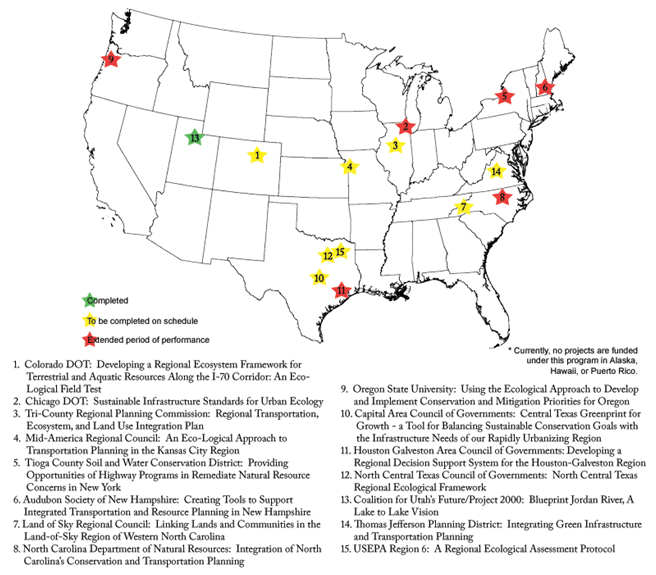
FHWA funds 15 Eco-Logical grants across the nation, as presented in Figure 1 below. This report includes information on each grantee's status, accomplishments, and challenges between January and December 2009. This section provides summaries of each grant project, highlighting outcomes and challenges to date. An asterisk next to the period of performance of a given project indicates an extension of that project's period of performance.
Figure 1: Eco-Logical Grant Projects
|
Back to top
Developing a Regional Ecosystem Framework for Terrestrial and Aquatic Resources along the I-70 Corridor, Colorado: An Eco-Logical Field Test
Colorado Department of Transportation, Total Cost: $323,330, FHWA Share: $152,500
Period of Performance: 36 months, Dates: May 22, 2008 - May 22, 2011
AOTR: Dennis Durbin; Grant Project Website: https://www.codot.gov/projects/i70mountaincorridor/i-70-old-mountaincorridor
Project Goals
The Colorado Department of Transportation (CDOT) Eco-Logical grant project aims to help CDOT identify mitigation activities and create tailored maintenance practices for the I-70 Corridor. To accomplish this goal, CDOT created a Regional Ecosystem Framework (REF)3 to test along the I-70 Corridor.
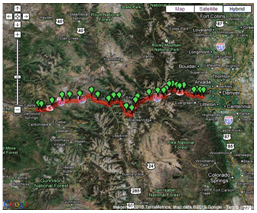 Figure 2: The visual output of the I-70 Wildlife Watch website.
Project Activities
In order to meet the CDOT Eco-Logical grant project goals, the project team is collecting terrestrial and aquatic connectivity data using GIS tools and developing criteria to identify and prioritize mitigation measures.
CDOT's project partner is the Center for Native Ecosystems (CNE). The project team has developed a web-based tool to analyze wildlife crossing data for use in the transportation planning process; these data are currently being collected via a reporting website (https://www.codot.gov/projects/i70mountaincorridor/i-70-old-mountaincorridor) for the I-70 Corridor. Initial results show that wildlife crossings are more dispersed than predicted. The project team will continue to monitor the crossings for the next year, using the winter months for data refinement and analysis.
Key Accomplishments
While CDOT believes the web-based tool will be beneficial to its current and future transportation planning projects, the project team noted that the real value of the grant project has been the improved and strengthened relationships with resource agencies. This Eco-Logical project has made CDOT more comfortable in addressing issues with partner organizations, and the project team looks forward to expanding on these relationships in the future. CDOT hopes that the work done on the I-70 Corridor will be applicable to other agencies nationwide.
Challenges
In the initial stages of the Eco-Logical project, the CDOT project team expressed a concern that it experienced "a lack of ownership" over the development of the website tool and methodologies for data collection, as the CNE had written and executed the scope for this work.
Future Steps
The CDOT project team members anticipate being more engaged as they take charge of data refinement and analysis in the upcoming stages of the project.
Back to top
Sustainable Infrastructure for Urban Ecology
Chicago Department of Transportation, Illinois, Total Cost: $147,608, FHWA Share: $73,281
Period of Performance: 27 months, Dates: August 22, 2008 - November 21, 2010*
AOTR: Kevin Moody; Grant Project Website: no longer available
Project Goals
The Chicago Department of Transportation (CDOT) Eco-Logical grant project is part of a larger undertaking to construct a sustainable streetscape demonstration project using Leadership in Energy and Environmental Design (LEED) principles.
Project Activities
The CDOT project team made significant progress in the outreach element of its grant, which includes:
- A draft of an educational handbook;
- Information kiosks that teach the public about sustainable street design; and
- A sustainable design manual, which outlines the sustainable design goals of the CDOT project, explains whether the project achieved each goal, and assesses the streetscape construction process.
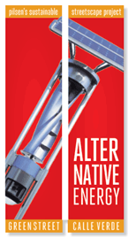 Figure 3: An example of new CDOT streetscape banner
Over the past year, CDOT has also furthered its partnership with the Benito Juarez High School, located on the project corridor, by integrating the Eco-Logical project into the school's science and architecture curricula. CDOT plans to involve students in future monitoring of the project site.
Key Accomplishments
Among CDOT's successes is an important partnership with the Center for Neighborhood Technology aimed at improving project outreach and communication. A major accomplishment of this partnership was a day-long summit that convened municipal governments, NGOs, and local and Federal agencies to learn about and discuss the creation of sustainable infrastructure.
The workshop positioned CDOT to serve as a clearinghouse of sustainable street information for municipalities across the region. This workshop also helped CDOT foster new relationships with environmental agencies, especially the EPA Region 5, which plans to use CDOT's workshop as a model to create a similar workshop for student engineers.
Challenges
The most notable challenge CDOT has encountered thus far was an initial delay caused by a major change in the subcontractor. As a result, construction of the actual streetscape interventions will take place later than planned, from spring through fall of 2010. The sustainable design manual will not be finalized until after the construction elements of the project are complete.
Due to the nature of the bidding process for construction projects in Chicago, potential contractors are given incentives to adopt the least expensive approach rather than the most sustainable approach. CDOT may need to obtain a city ordinance to defend the legality of selecting a contractor by sustainable intentions rather than cost. As an urban-based project addressing a micro-scale, CDOT also faces street-scale environmental challenges that set it apart from other Eco-Logical projects, such as drainage and lighting. While urban and rural projects may be the same in spirit, the Eco-Logical approach may need to be applied differently in varied settings and scales.
Future Steps
CDOT hopes that the demonstration project with the accompanying design manual and outreach materials will help future project managers in the region look for opportunities to incorporate green infrastructure into their transportation projects.
Back to top
Regional Transportation, Ecosystem, and Land Use Integration Plan
Tri-County Regional Planning Commission, Illinois, Total Cost: $218,954, FHWA Share: $109,477
Period of Performance: 24 months, Dates: April 4, 2008 - April 3, 2010
AOTR: Neel Vanikar, Grant Project Website: https://tricountyrpc.org/
Project Goals
The Tri-County Regional Planning Commission (TCRPC) is developing an integrated planning document. This document, known as the "Eco-Logical plan," will serve as a comprehensive guide to land use, transportation, ecosystems, and infrastructure in the Peoria, Illinois, region. The plan will establish regional priorities for infrastructure development and assist local stakeholders in making development decisions.
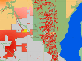 Figure 4: Demonstration of plan integration for the North Peoria area.
Project Activities
The TCRPC project team is currently writing the final draft of its Eco-Logical plan. After completion of this plan in early 2010, the project team will conduct outreach to regional stakeholders. The outreach will focus on relevant policy concepts and technical implementation strategies.
Key Accomplishments
When the TCRPC project team examined regional environmental, land use, and infrastructure plans, it found that current and projected residential growth in the Peoria region overlaps with environmentally sensitive areas. Based on its analysis of existing regional plans and discussions with local government officials, the project team identified five key themes (agricultural preservation, balanced growth, economic development, environmental stewardship, and public infrastructure) that recognize the region's priorities for sustainable growth and infrastructure and created related guidelines. TCRPC worked to incorporate these themes into the region's recent update of its LRTP to be adopted in January 2010. The TCRPC project team has also worked with the three counties, Peoria, Tazewell, and Woodford, in the Peoria region to adopt County Comprehensive Plans that formalize the work done in this grant project. One of the counties has officially adopted its comprehensive plan, and the other two counties will adopt their plans in early 2010.
Challenges
TCRPC has faced a key challenge in the past year: control over transportation, land use, and environmental planning at the regional government level in the Peoria region is spread among 46 general purpose units of government. Local jurisdictions that govern planning and implementation in the region appear to be resistant to "green" concepts and are willing to accept negative environmental impacts in exchange for economic growth. This attitude stems from a long history of recessions and economic challenges that have occurred in the past and currently face the region. Throughout the project, TCRPC staff focused on emphasizing shared transportation goals among TCRPC, local transportation agencies, and local governments. This cooperative approach enabled TCRPC to make some progress towards overcoming these challenges.
Future Steps
Moving forward, TCRPC plans to use its Eco-Logical plan to analyze projects in the Transportation Improvement Program (TIP) and to continue to work with local governments to design sustainable projects that align with the Eco-Logical plan. TCRPC also plans to use watershed data to identify potential mitigation opportunities and then make these data available to State and local agencies. TCRPC noted that the priorities outlined in its plan will allow it to use infrastructure as a tool to achieve future regional goals, such as sustainable growth and environmental protection.
Back to top
An Eco-Logical Approach to Transportation Planning in the Kansas City Region
Mid-America Regional Council, Missouri, Total Cost: $180,000, FHWA Share: $90,000
Period of Performance: 24 months, Dates: March 18, 2008 - March 18, 2010
AOTR: Mary Gray, Grant Project Website: No longer available
Project Goals
The Mid-America Regional Council (MARC) grant project will develop two distinct final products:
- Multi-faceted educational programs to strengthen interagency relationships; and
- A collaborative and integrative environmental-transportation planning and consultation process for the region.
Project Activities
Throughout the past two years, the MARC project team focused on creating products and linkages that will ultimately facilitate good planning and provide easy access to data not previously available to the public. MARC uses an online mapping service to make data more readily available as a means of pursuing its objective to become a regional data clearinghouse. MARC has been successfully facilitating interactions between environmental resource agencies and transportation groups and helping to clarify the potential linkages between ecological and transportation planning process for the environmental agencies located in the Kansas City metro-region.
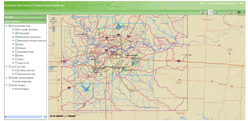 Figure 5: An image from the "Green Region Data Map" tool.
Key Accomplishments
The MARC Board of Directors adopted the document "Linking Environmental & Transportation Planning: An Action Plan" (Action Plan) in May 2009, which includes recommendations and best practices that will guide MARC's development of a sustainable transportation framework for the region. MARC conducted four public planning workshops at which the project team presented and solicited input on the Action Plan.
Challenges
The project team is proud to announce that it assisted in overcoming an initial communication challenge by helping to build consensus among local officials, transportation planners, and environmental agency representatives in order to develop a proactive, ecosystem-based mitigation framework to incorporate into the region's LRTP.
Future Steps
MARC plans to complete a framework to guide the creation of an ecosystem-based green infrastructure plan (MARC does not anticipate that the green infrastructure plan will be completed within the scope of the Eco-Logical grant project). MARC will likely build such a framework around watersheds, but development and implementation of the framework will continue past the period of performance, into 2010.
Back to top
Providing Opportunities for Highway Programs to Remediate Natural Resource Concerns in New York
Tioga County Soil and Water Conservation District, Total Cost: $232,390, FHWA Share: $112,490
Period of Performance: 36 months, Dates: March 4, 2008 - March 5, 2011
AOTR: Bethaney Bacher-Gresock, Grant Project Website: no longer available
Project Goals
The goal of the Tioga County Soil and Water Conservation District (TCSWCD) Eco-Logical project is to work with the New York FHWA Division Office and New York State Department of Transportation (NYSDOT) staff to develop REFs4 to test study basins in the Tioga County region and identify areas for conservation or mitigation.
Project Activities and Key Accomplishments
The project team has started collecting GIS data and selecting watersheds as target project areas. Staff also attended regional meetings at which they made key connections with MPOs and learned about the regulations that govern the transportation planning process and the role of MPOs in that process.
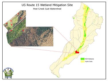 Figure 6: The US Route 15 wetland mitigation site.
Based on its newfound understanding of the MPO planning process, the project team discussed the development of a compatible, proactive mitigation program with MPO representatives. These regional meetings also afforded MPOs the opportunity to learn about environmental resources that TCSWCD could offer.
Challenges
The project team experienced challenges in agreeing upon project deliverables and goals with NYSDOT, which is the project's match organization. The project team found strategic differences between NYSDOT's approach to mitigation and TCSWCD's own approach. However, TCSWCD is committed to working with NYSDOT to resolve these differences and believes the project work has informed both agencies about each others' resources and capabilities. TCSWCD staff will work with FHWA and NYSDOT to reassess the project deliverables to meet the needs of all three agencies. While TCSWCD expressed some mixed feelings over its initial Eco-Logical grant program experiences, the organization believes the data generated and the relationships forged through the process will be beneficial to the county and to mitigation in the region.
Future Steps
TCSWCD plans to refocus its project to incorporate close work with MPOs into the grant project scope. TCSWCD also would like to assist the MPOs with environmental mitigation as each MPO goes through its transportation planning processes. TCSWCD envisions integrating its own resources and knowledge of environmental planning into the MPO planning process.
Back to top
Creating Tools to Support Integrated Transportation and Resource Planning in New Hampshire
Audubon Society of New Hampshire, Total Cost: $48,939, FHWA Share: $24,464
Period of Performance: 20 months, Dates: September 1, 2008 - April 30, 2010*
AOTR: Dennis Durbin, Grant Project Website: https://www.nhaudubon.org/
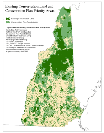 Figure 7: Existing conservation land and conservation plan priority areas in New Hampshire.
Project Goals
The Audubon Society of New Hampshire's (NHA) Eco-Logical project was designed to develop a set of data and tools to support the coordination of transportation and resource planning in New Hampshire.
Project Activities
The "Impact Assessment Framework" is a tool that will measure the impacts of transportation projects on natural resources. NHA also convened a Partnership Work Group (PWG) made up of representatives from resource groups and local governments. The purpose of the PWG meetings was to reach an agreement between all parties about the extent of transportation impacts on selected natural resources. NHA met with the New Hampshire Department of Transportation (NHDOT), the New Hampshire Department of Environmental Services, and the New Hampshire Fish and Game Department to outline steps of the Eco-Logical process and map NHA's progress in collecting data and developing tools.
Key Accomplishments
The Eco-Logical grant has helped NHA work collaboratively with State and regional agencies, including an RPC and NHDOT. It has also enhanced NHA's capacity to facilitate partnerships between environment and transportation agencies. Through peer exchanges, NHA aspires to utilize Eco-Logical principles to expand its project to all of New England.
Challenges
A major challenge for NHA has been managing meetings with diverse participants and agenda topics. Participation at meetings has been inconsistent, requiring project staff to address the resulting gaps in knowledge by providing "recaps" at the beginning of meetings.
Project staff also found that the Eco-Logical approach conflicted with the traditional, linear practices of some of its partner agencies.
Future Steps
In order to strengthen its approach to implementing Eco-Logical, NHA plans to work with a local RPC to compare and overlay transportation corridors and long-range plans as well as to identify environmental impacts.
Back to top
Linking Lands and Communities in the Land of Sky Region of Western North Carolina
Land of Sky Regional Council, Total Cost: $208,000, FHWA Share: $104,000
Period of Performance: 24 months, Dates: March 17, 2008 - March 17, 2010
AOTR: Mary Gray, Grant Project Website: http://www.landofsky.org/ecdpast.html
Project Goals
The Land of Sky Regional Council (LOSRC) Eco-Logical grant project aims to develop a regional conservation network that feeds ranked natural and cultural resources data into a GIS model. The model can then be used as a guide for conservation and development efforts in the Land of Sky region.
Project Activities
The LOSRC project team completed three component assessments consisting of individual water quality, wildlife habitat and biodiversity, and agriculture models. The next steps of the project will be to integrate the ranked data from each of the three assessments into a GIS model. The resulting GIS-based maps will show a unified green infrastructure network that will be reviewed and updated to consider natural phenomena and projected development.
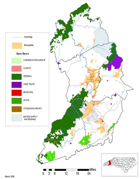 Figure 8: Land of Sky Regional Council open space map.
The grant project required LOSRC to develop new working relationships with local and State agencies and NGOs. LOSRC also conducted a series of open houses and prepared educational materials to help the public interpret the assessments. This has led to a greater regional awareness of ecological systems, data sharing, and integration with transportation and other regional plans among all partner organizations.
Key Accomplishments
The LOSRC Eco-Logical project has already gained regional, State, and Federal recognition. LOSRC staff plans to be involved in data collaboration and technology transfer with State and Federal agencies after the grant's completion. An additional accomplishment is that the Blue Ridge National Heritage Area in North Carolina committed to replicate LOSRC's "Eco-Logical planning process" for the rest of the counties in the area through its General Management Plan. LOSRC will serve as the pilot for this approach.
Challenges
LOSRC initially struggled to create a process and a model that fit the sustainable development ethic of its region. The project team overcame this challenge by allotting additional time to develop an updatable, transparent model. LOSRC faced challenges in sustaining participation from local government stakeholders and matching the project schedule with other major regional planning efforts, such as the LRTP. The project team has expanded its outreach efforts with local governments to educate them about how to incorporate the network into their long-range plans, even amid differing project schedules.
Future Steps
LOSRC believes its green infrastructure network will provide data to inform project selection for inclusion in the State Transportation Improvement Plan, a process which is currently mostly qualitative but is moving towards quantitative metrics. LOSRC also hopes that FHWA's role in Eco-Logical will encourage the North Carolina Department of Transportation (NCDOT) to utilize the green infrastructure network in future transportation planning.
Back to top
Integration of North Carolina's Conservation and Transportation Planning
North Carolina Department of Environment and Natural Resources, Total Cost: $274,257, FHWA Share: $136,689
Period of Performance: 25 months, Dates: April 3, 2008 -April 30, 2010*
AOTR: Dennis Durbin; Grant Project Website: No longer available
Project Goals
The North Carolina Department of Environmental and Natural Resources (NCDENR) grant project goal is to develop a Strategic Conservation Plan for North Carolina and to collaborate with NCDOT to integrate the Eco-Logical framework into the transportation planning process. A major project component is a series of wildlife habitat maps for each of the State's regions, which NCDENR has nearly completed.
Project Activities
NCDENR completed a pilot in Hickory, North Carolina, to test the initial tools created as part of this project. The Hickory MPO found that the tools and biodiversity data that NCDENR provided was helpful in pre-planning and setting fieldwork priorities, but utilizing the data did not substitute for a more complete environmental analysis.
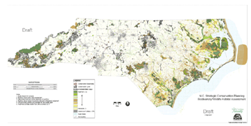 Figure 9: Sample Wildlife Habitat Assessment map from the project's "Conservation Planning Tool."
Key Accomplishments
A new data system will allow the agency to continue to work with current project partners to ensure the system's data remains current and is actively applied to transportation planning projects. Initial data from the grant project has already received validation from the Natural Heritage Trust Fund Board of Trustees as well as other North Carolina land trusts that are using the new data or requiring others to use the data. NCDENR staff is also serving on an interagency integration team at NCDOT to improve the long range planning and project delivery process.
Challenges
NCDENR identified keeping data current amid North Carolina's rapid development as a major challenge to its Eco-Logical project. To cope with this issue, NCDENR partnered with the North Carolina Wildlife Resources Commission (WRC), an agency that receives regular funding through State wildlife grants to frequently generate data. Another challenge NCDENR identified was integrating ecological considerations into a planning process that is traditionally motivated by economic and transportation issues. NCDENR believes that the provision of strong, reliable data that show clear benefits of an Eco-Logical approach will help to change the underlying culture in transportation agencies.
Future Steps
As NCDENR obtains biodiversity data from completed mapping in the rest of the State, it will circulate the data to all of North Carolina's RPOs and MPOs for use in pre-planning. NCDENR hopes that using this new data will help planners avoid environmentally sensitive areas when planning transportation projects. As the project continues, NCDENR will continue to meet regularly with its Interagency Leadership Team, which consists of representatives from Federal and State resource and transportation agencies, to determine how to make mapping and data most useful to the transportation process.
Back to top
Using the Eco-Logical Approach to Develop and Implement Conservation and Mitigation Priorities for Oregon
Oregon State University, Total Cost: $101,552, FHWA Share: $49,962
Period of Performance: 20 months, Dates: June 11, 2008 - February 11, 2010*
AOTR: Mary Gray; Grant Project Website: no longer available
Project Goals
Two key project goals of the Oregon State University (OSU) Eco-Logical grant are:
- Identify conservation priority areas, as selected by State agencies and conservation groups.
- Consolidate the disparate data from each priority area into an online format.
The project builds upon two conservation strategies:
- The Oregon Conservation Strategy (OCS), an action plan for long-term conservation of wildlife and habitats in the State of Oregon developed by the Oregon Department of Fish and Wildlife.
- The Comprehensive Mitigation and Conservation Strategy developed by the Oregon Department of Transportation (ODOT).
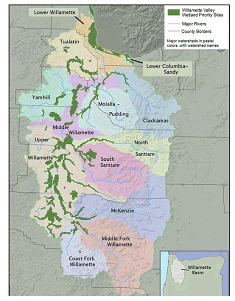 Figure 10: Wetland priority basins for the Willamette Valley.
Project Activities
OSU has consolidated data from priority areas, and the project team has worked closely with resource agencies and other partners to obtain appropriate data. OSU recently integrated data into models that can be used by ODOT and the U.S. Fish and Wildlife Service (FWS) in transportation and mitigation planning. The OSU project team plans to complete these models in early 2010. The data models will be tested in a pilot study in the Willamette Valley.
Key Accomplishments
While OSU had previously partnered with many of the agencies participating in this project, including ODOT, the Eco-Logical grant allowed OSU to serve as problem solvers in addition to data providers.
Challenges
In Oregon, a conservation ethic among the general public and its elected officials has served as both a challenge and an opportunity. Statewide, agencies within Oregon have been pursuing mitigation strategies ahead of national requirements but have often lacked the resources to fully implement the solutions. OSU is supporting the efforts of local advocacy groups working to change the rules on existing mitigation banks. This will allow agencies to use their limited resources most efficiently rather than pursue inadequately funded solutions. A related challenge is that multiple agencies in Oregon have collected similar wildlife habitat and wetland data, but there is no central agency in the State that has combined the disparate data sets and created a shared framework.
Future Steps
OSU will create GIS models to share with ODOT. Eventually, OSU plans to link its data with the ODOT State Bridge Delivery Program, which is a $1.3 billion, 10-year effort to repair and replace hundreds of bridges in Oregon. The Bridge Delivery Program relies on static data, and OSU hopes to automatically import spatial data to provide current wildlife information to inform this major infrastructure project.
Through the TRB's "Strategic Highway Research 2 - Integration of Conservation, Highway Planning and Environmental Permitting Through Development of an Outcome-Based Ecosystem-Scale Approach and Corresponding Credit System" program, OSU received funding to perform research and work with five other States to complete similar statewide conservation strategies.
Back to top
Central Texas Greenprint for Growth - a Tool for Balancing Sustainable Conservation Goals with Infrastructure Needs for Our Rapidly Urbanizing Region
Capital Area Council of Governments, Total Cost: $227,764, FHWA Share: $113,882
Period of Performance: 24 months, Dates: May 16, 2008 - May 16, 2010
AOTR: Bethaney Bacher-Gresock; Grant Project Website: https://www.capcog.org/
Project Goals
The Capital Area Council of Governments (CAPCOG) Eco-Logical grant project goal was to create a "Greenprint" for the region. The Greenprint document will help planners and transportation agencies to implement future infrastructure in ways that do not fragment, disturb, or destroy local and regional ecosystems. The Central Texas Greenprint expands upon a previous CAPCOG project, the Travis County Greenprint, by adding the other counties in the Austin-Round Rock metropolitan statistical area (one county, Williamson County, did not participate).
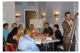 Figure 11: Greenprint stakeholder meeting in Bastrop County. (Courtesy of Diane Miller)
Project Activities
CAPCOG worked closely with local stakeholders and planners to complete a visioning process, create GIS models, and publically release the Central Texas Greenprint for Growth in November 2009. The Greenprint includes the final report, maps, data, and digital versions of all materials on its website. CAPCOG places a priority on engaging the planning community and elected officials to demonstrate the benefit of the Greenprint, as the project is expected to have the greatest effect if incorporated into local plans and policies.
Key Accomplishments
A recent Texas Department of Transportation (TxDOT) effort to purchase land for mitigation validates the Greenprint's findings. The purchased parcel corresponds to a high conservation priority area on the Greenprint; and although TxDOT did not specifically consult Greenprint in its parcel selection, CAPCOG still finds the selection to be an affirmation of the Greenprint process. CAPCOG hopes to see local governments make similar decisions as the Greenprint document is disseminated.
As a council of governments, CAPCOG sees its role as providing elected officials with high-quality data that can inform policy decisions. The project team hopes to prove the value of the Greenprint to local governments and to the FHWA Division Office so that these entities will incorporate the Greenprint into their transportation planning efforts.
Challenges
CAPCOG expected opposition from property rights advocates and the business community since they have traditionally been vocal in the Austin region. However, the project team was surprised to experience pushback from environmental groups, who were opposed to identifying areas to channel growth. The project team also observed an ideological challenge in negotiating between polar interest groups. Both environmental and development advocates appeared unwilling to compromise in order to reach a middle ground. CAPCOG believes that its role in this conflict is to provide concrete data that helps the two sides achieve some common ground.
Future Steps
To support the priority of incorporating the Greenprint into local plans, Envision Central Texas, a project partner, plans to continue its ongoing outreach efforts by hosting two regional meetings about the Greenprint. Through these meetings, the group hopes to receive feedback on the Greenprint, help planners incorporate the Greenprint into planning processes, and demonstrate how the Greenprint can identify basic conservation priorities.
Back to top
Developing a Regional Decision Support System for the Houston-Galveston Region
Houston-Galveston Area Council, Texas, Total Cost: $200,000, FHWA Share: $100,000
Period of Performance: 27 months, Dates: March 13, 2008 - June 14, 2010*
AOTR: Diane Turchetta; Grant Project Website: https://www.h-gac.com/eco-logical
Project Goals
The Houston Galveston Area Council (H-GAC) Eco-Logical project's goal is to create a GIS model that will identify environmental resources and potential mitigation areas. The model will serve as a regional decision support system that calls out priorities for protection and mitigation.
| Eco-Service Rating |
High=3 |
Med=2 |
Low=1 |
Total |
Average |
| Maintain and Improve Water Quality |
12 |
2 |
0 |
40 |
2.86 |
| Sustain Biodiversity |
12 |
2 |
0 |
40 |
2.86 |
| Regulate Timing and Distribution of Water Flows |
10 |
4 |
0 |
38 |
2.71 |
| Flood Protection |
10 |
3 |
1 |
37 |
2.64 |
| Improve Air Quality |
6 |
7 |
1 |
33 |
2.36 |
| Cycle and Store Nutrients |
5 |
8 |
1 |
32 |
2.29 |
| Provide Quality of Life Benefits |
6 |
6 |
2 |
32 |
2.29 |
| Control Erosion |
5 |
7 |
2 |
31 |
2.21 |
| Reduce Storm Surge Impact |
5 |
7 |
2 |
31 |
2.21 |
| Provide Recreation |
6 |
5 |
3 |
31 |
2.21 |
| Reduce GHG |
4 |
7 |
3 |
29 |
2.07 |
| Moderate Temperature |
4 |
6 |
4 |
28 |
2.00 |
| Provide Food Production |
3 |
6 |
5 |
26 |
1.86 |
Figure 12: Eco-Service ratings devised in an advisory group
Project Activities
H-GAC has completed the resource mapping component of its project and has made significant progress toward completing a resource valuation tool. To assure that the valuation tool will have the greatest ongoing relevance, H-GAC designed the tool to automatically incorporate the most current data available.
Key Accomplishments
H-GAC has begun work on its final report and plans to have all deliverables completed by June 2010 (based upon an agreement extension).
Challenges
H-GAC faced a major challenge in determining how to best design the GIS tool for its regional decision support system; H-GAC learned that the agencies in its advisory group had conflicting definitions of "level of ecological service." To resolve this issue, H-GAC guided the advisory committee, composed of resource, planning, and transportation agencies, to reach a consensus on this definition by selecting eight quantifiable metrics for the valuation tool.5
H-GAC identified a second challenge related to the ongoing engagement of its advisory committee. The project team found that the aerial imagery mapping component of the project and model calibration took more time than H-GAC expected, leading to a six-month period in which H-GAC had no new products to engage the advisory committee. The H-GAC project team worried that this may have contributed to a sense of disconnect among committee members. A related concern is that the FHWA Texas Division office and TxDOT were initially unengaged in the project. To alleviate this challenge, H-GAC established liaisons with FHWA and TxDOT, and the project team hopes to report on the outcome of these new liaisons in the next fiscal year.
Future Steps
In 2010, the H-GAC project team plans to conduct outreach within H-GAC and among resource agency partners to incorporate the tool into regional plans. As one of the first major efforts in the Houston-Galveston Area to bridge transportation and environmental issues, this Eco-Logical grant project plans to include environmental groups in transportation planning decisions through procedural changes in the MPO side of H-GAC, such as establishing a subcommittee within the MPO to focus on environmental issues in transportation planning.6
Back to top
North Central Texas Regional Ecological Framework (REF)
North Central Texas Council of Governments, Total Cost: $355,000, FHWA Share: $177,500
Period of Performance: 31 months, Dates: May 9, 2008 - December 9, 2010
AOTR: Michael Culp, Grant Project Website: https://www.nctcog.org/trans/quality/environmental-coordination/regional-ecosystem-framework
Project Goals
The North Central Texas Council of Governments (NCTCOG) Eco-Logical project aims to develop an REF to help agencies assess environmental impacts of proposed infrastructure projects and enhance multi-agency understanding of critical resource protection areas. The REF is an overlay of maps of agencies' individual plans7 that includes a corridor assessment component in which NCTCOG will analyze resource agency management plans and social and environmental GIS data to assess potential environmental effects by watershed. The grant project focuses on three pilot corridors associated with transportation projects where related impacts are being assessed at sub-watershed levels (Lake Lavon Transit Line, State Highway 360, and State Highway 170). Using the Eco-Logical approach, NCTCOG has a long-term goal (outside the scope of this grant project) of identifying priorities and strategies for each of the hundreds of wetlands in the region.
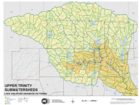 Figure 13: Lake and river drainage patterns of the Upper Trinity Sub-watersheds, Texas.
Project Activities
NCTCOG conducted a series of stakeholder meetings introducing the REF strategy and explaining how the REF fits within the eight-step Eco-Logical approach.
Key Accomplishments
In the past year, the project team identified vital environmental data, including watershed and habitat data, in the pilot corridors. They formed initial links with key stakeholders in the pilot communities, which they plan to strengthen as they move into a cumulative effects analysis. NCTCOG plans to use the initial findings of its project to identify broad mitigation and permitting strategies that cities can consider as part of their transportation development process.
Challenges
NCTCOG has found several challenges in working with stakeholders. First, NCTCOG had to maintain stakeholder interest in the project while simultaneously managing expectations for quick action. Second, some agency stakeholders were accustomed to working at scales either much larger or smaller than the project scale, and NCTCOG had to present data at scales comfortable to these different groups. Finally, NCTCOG holds the perception that resource and regulatory agencies tend to be involved in very particular stages of the planning and project-review process; each agency's respective focus on technical parts of the process might detract from its ability to view and participate in the planning process holistically.
Future Steps
Technical efforts to collect watershed data are a key ongoing component of the project. Ultimately, NCTCOG will overlay the data on three transportation corridors to complete its cumulative effects analysis. While NCTCOG selected three corridors as an illustrative example for the large region, it is still seeking ways to portray data from these corridors so that the REF is relevant to other infrastructure projects or watersheds. Once the overlay is complete, NCTCOG will meet with communities to discuss all potential impacts of infrastructure development.
Back to top
Blueprint Jordan River, A Lake-to-Lake Vision
Coalition for Utah's Future/Project 2020, Total Cost: $208,000, FHWA Share: $85,000
Period of Performance: 12 months, Dates: June 9, 2008 - June 9, 2009
AOTR: Frederick Bowers, Grant Project Website: https://jordanrivercommission.com/vision/
Project Goals
The goal of the Blueprint Jordan River project was to create a set of principles for protecting and improving the Jordan River corridor. The project focused on environmental goals but also touched upon environmental education, recreation, low-impact development, and access to the river and regional trails.
Project Activities
The project team used a broad public involvement process that engaged government officials, resource agencies, and transportation agencies to form a shared vision for the Jordan River corridor. Envision Utah (a member of the Coalition for Utah's Future) published the report in December 2008 and spent the first few months of 2009 completing the outreach component of its project.
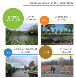 Figure 14: Ranking of four vision scenarios for the Jordan River.
Key Accomplishments
Through Envision Utah's outreach efforts, 15 out of 18 local governments in the project area adopted resolutions supporting the Blueprint report. The report included several designated protection areas, one of which was later proposed as the site of a new commuter rail station. Due to the consensus process involved in creating the Blueprint Jordan River, opponents of the station had sufficient justification to successfully demand that the station be located in a non-sensitive area. Another project success is that the Utah Transit Authority (UTA) used one of the major preservation sites identified in the Blueprint report as a mitigation bank for a light rail line.
As a result of the use of Eco-Logical principles in the Blueprint Jordan River, Envision Utah will incorporate Eco-Logical into an upcoming transportation planning project for Seven Wasatch Canyon. While Envision Utah believed that its organization's ethos has always been well aligned with the Eco-Logical approach, its experience with the Eco-Logical grant project is allowing the organization to pursue innovative planning projects across the State using integrated transportation and environmental planning.
Challenges
The Blueprint Jordan River project faced challenges balancing the individual interests of municipalities along the river with the common interest of the river. Historically, some municipalities had been focused on the immediate benefits of an infrastructure project, including enhanced mobility and economic development; and they did not immediately see the benefits of making small, local changes to benefit regional river health.
Future Steps
Since the completion of the Eco-Logical grant project, Envision Utah has worked with an Implementation Committee, meeting monthly to work out the governance details of a new Jordan River Commission. The Commission will be charged with implementing the findings and recommendations from the report. Furthermore, the Commission will collect dues from each community in the project area and use these dues to pay a full-time staff to implement the Commission's recommendations.
Back to top
Integrating Green Infrastructure and Transportation Planning
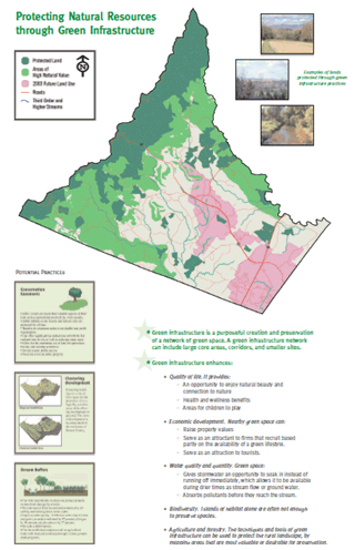 Figure 15: A page from the TJPDC Green Infrastructure Study.
Thomas Jefferson Planning District Commission, Virginia, Total Cost: $155,731, FHWA Share: $77,833
Period of Performance: 36 months, Dates: May 20, 2008 - May 20, 2011
AOTR: Bethaney Bacher-Gresock, Grant Project Website: https://campo.tjpdc.org/eco-logical/
Project Goals
The Thomas Jefferson Planning District Commission (TJPDC) Eco-Logical project is to develop a green infrastructure plan to connect transportation, development, and natural resource plans in the five-county planning district.
Project Activities
In the past year, TJPDC completed a green infrastructure study and gained support for the study by all of the TJPDC member governments. The MPO incorporated environmental analysis from the green infrastructure study into its recently adopted LRTP.
Key Accomplishments
This Eco-Logical project has allowed TJPDC to bring diverse stakeholders together to seek shared priorities. The project team hopes that conversations started during the stakeholder meetings will create a forum for transportation and environmental agencies to come together.
Challenges
The project team foresees challenges relating to an active environmental community. TJPDC worries that the environmental community may over-identify mitigation and impact sites, causing conflict with other groups in the area. TJPDC also anticipates that regulatory agencies will apply narrow standards to determine appropriate mitigation sites. TJPDC hopes to overcome these challenges by working with agencies to focus on overall priorities and adopt a broader perspective.
Future Steps
TJPDC believes that the green infrastructure plan will not only help the planning district to enhance their infrastructure but it will also improve the quality of life in the region.
As next steps, TJPDC will overlay transportation projects on the green infrastructure data and identify potential impact and mitigation areas. After the overlay is complete, TJPDC will hold meetings with local governments, regulatory agencies, and other public groups to present and discuss the impacts and mitigation opportunities identified in the overlay. The goal of these meetings will be to achieve consensus on the mitigation opportunities.
Back to top
A Regional Eco-Logical Assessment Protocol for the South Central United States
U.S. Environmental Protection Agency, Region 6, Total Cost: $170,500, FHWA Share: $100,000
Period of Performance: 36 months, Dates: May 1, 2008 - May 1, 2011
AOTR: Mark Sarmiento, Grant Project Website: https://www.epa.gov/aboutepa/epa-region-6-south-central
Project Goals
The goal of the EPA Region 6 Eco-Logical grant project is to develop a Regional Ecological Assessment Protocol (REAP) as an expansion of the Texas Ecological Assessment Protocol (TEAP). The TEAP and REAP are tools that use existing GIS data to classify land on the basis of ecological importance. The REAP will cover all of Region 6, which includes Arkansas, Louisiana, New Mexico, Oklahoma, and Texas.
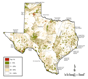 Figure 16: TEAP composite, that is a model for the REAP composites.
Project Activities
EPA Region 6 has collected nearly all of the needed data over the past year, and the project team has started merging data sets to create the GIS tool.
Key Accomplishments
The EPA project team found new relationships and opportunities created through the grant process, including greater opportunities for environmental agencies to employ GIS modeling. In terms of future benefits, EPA anticipates that REAP will allow transportation planners at the MPO level to identify areas of avoidance or to test the environmental impacts of different alternatives.
Challenges
EPA anticipated challenges in collecting data from six separate States. In most cases, EPA had no prior relationships with the State-level agencies; however, the EPA Region 6 project team found that it was able to collect all of the data with relative ease, with the exception of Louisiana, for which the project team is still pursuing data. Some States were reluctant to give out specific data, but the EPA Region 6 project team worked with each State to explain the value of the project as a useful transportation planning tool. Furthermore, the team clarified that it would make the REAP tool available to the States. EPA also agreed not to release data except in an aggregated form, thereby protecting the classified nature of certain data sets.
Future Steps
Once the final report is completed and the data are made publically available, EPA staff will visit state departments of transportation and FHWA offices to educate States about the REAP. EPA staff plans to use these visits to start conversations between transportation and wildlife agencies about joint planning.
Back to top
APPENDIX A: GRANT RECIPIENT PRESENTATIONS
| Project |
Event |
| Colorado DOT |
| State |
Statewide meetings related to the I-70 corridor |
| Chicago DOT |
| International |
University of Toronto educational presentation |
| National |
American Society of Landscape Architects Annual Meeting
Congress for New Urbanism workshop |
| TCRPC |
| National |
GIS Applications in Eco-Logical Grant Projects Peer Exchange |
| MARC |
| International |
International Conference on Ecology and Transportation |
| National |
AASHTO GIS for Transportation Symposium
TRB Committee Meeting, Atlanta, GA
"Beyond Transportation's Footprint," TRB ADC10 Meeting, Shepherdstown, WV
|
| TCSWCD | No presentations to date |
| NHA |
| International |
Two Countries, One Forest (TCOF) Peer Exchange |
| National |
GIS Applications in Eco-Logical Grant Projects Peer Exchange |
| LOSRC |
| National |
Association of Metropolitan Planning Organizations Annual Conference
Exhibition at the U.S. Botanic Garden, Washington D.C.
|
| State |
North Carolina Association of Metropolitan Planning Organizations Conference
North Carolina American Planning Association Conference |
| NCDENR |
| National |
Green Infrastructure Conference |
| State |
North Carolina Association of Metropolitan Planning Organizations Conference
North Carolina Joint MPO and RPO Meeting |
| OSU |
| National |
AASHTO GIS for Transportation Symposium
NatureServe Conservation Conference
TRB and NatureServe Workshops
GIS Applications in Eco-Logical Grant Projects Peer Exchange
National Association of Environmental Professionals Annual Conference |
| CAPCOG |
| National |
FHWA Context Sensitive Solutions Regional Workshop
GIS Applications in Eco-Logical Grant Projects Peer Exchange |
| State |
Land, Water, People Conference
Texas GIS Forum |
| Local |
County and City Commissioner presentations
Plum Creek Watershed presentation |
| H-GAC |
| National |
National Association of Regional Councils - Parks and Recreation Subcommittee
New Partners for Smart Growth Annual Conference
GIS Applications in Eco-Logical Grant Projects Peer Exchange |
| State |
Texas American Planning Association Conference |
| Local |
Galveston Bay Council |
| NCTCOG |
| National |
"Beyond Transportation's Footprint," TRB ADC10 Meeting, Shepherdstown, WV
American Planning Association National Conference
FHWA Denver Corridor Planning Peer Exchange
GIS Applications in Eco-Logical Grant Projects Peer Exchange |
| State |
Presentation to the Maryland State Highway Administration |
| Envision Utah |
| National |
2010 River Rally |
| State |
Utah Watershed Symposium |
| TJPDC |
| National |
Small Metro Planning Group TRB Committee Meeting |
| EPA Region 6 |
| International |
International Conference on Ecology and Transportation |
| National |
FHWA Denver Corridor Planning Peer Exchange
GIS Applications in Eco-Logical Grant Projects Peer Exchange |
| State |
Maryland Water Resources Registry |
Back to top
Footnotes
Back to top

