FHWA-HEP-17-033
Printer-friendly PDF →
FHWA Eco-Logical Case Studies Series
Example of Implementing Eco-Logical Steps 5-6
Agency: North Carolina Department of Environmental Quality
Eco-Logical is an approach designed to help transportation, resource, and regulatory agencies integrate their infrastructure development and conservation planning processes and arrive at a joint set of environmental priorities. It organizes current methods to address natural resource identification, avoidance, minimization, and compensation into a systematic, nine-step process that starts at the beginning of the transportation planning process and concludes with establishing programmatic approaches to recurring natural resource issues that are implemented at the project level. This is one case study in a series that highlights how transportation agencies around the country are implementing the nine steps of Eco-Logical.
The Eco-Logical Approach
Eco-Logical’s nine steps organize how agencies can partner and integrate plans to identify environmental priority areas and ecological considerations in project planning and delivery. Agencies can apply the steps in order or independently of each other.
The steps, including Steps 5 and 6 featured in this case study, are:
Step 1:
Build and strengthen collaborative partnerships and vision
Step 2:
Characterize resource status and integrate natural environment plans
Step 3:
Create a Regional Ecosystem Framework (REF)
Step 4:
Assess effects on conservation objectives
Step 5:
Establish and prioritize ecological actions
Step 6:
Develop a crediting system
Step 7:
Develop programmatic consultation, biological opinion, or permit
Step 8:
Implement agreements, adaptive management and delivery projects
Step 9:
Update REF and plan
This case study describes how the North Carolina Department of Environmental Quality’s (NCDEQ) mitigation program embodies a landscape-scale approach to infrastructure development. In the mid-1990s, an estimated 70% of transportation projects in North Carolina were delayed due to a lack of sufficient compensatory mitigation that met mitigation success objectives. The NCDEQ Division of Mitigation Services (NCDMS), originally known as the Ecosystem Enhancement Program (EEP), was developed in cooperation with the U.S. Army Corps of Engineers (USACE). NCDMS implements off-site, watershed-based mitigation in areas with the greatest ecological need by working with State and local partners, including private landowners.
While NCDEQ did not follow the steps of the Eco-Logical approach directly, their process exemplifies many of the principles of Eco-Logical and therefore offers lessons to Eco-Logical practitioners. NCDEQ prioritized ecological actions and developed a crediting system, similar to steps 5 and 6 of Eco-Logical, through the following activities (2001-2016):
- Establishing a dedicated Division of Mitigation Services as directed by the North Carolina State legislature.
- Launching a two-year mitigation process improvement initiative with the North Carolina Department of Transportation (NCDOT), USACE, and other resource agencies to streamline delivery of transportation projects requiring mitigation.
- Establishing formal agreements with NCDOT and USACE describing use of their off-site mitigation and in-lieu fee (ILF) programs.
- Delivering compensatory wetland, stream, and buffer mitigation for more than $15 billion in transportation projects since 2003 with zero delays associated with mitigation.
Division of Mitigation Services
Mission: The North Carolina Division of Mitigation Services (NCDMS) provides cost-effective mitigation alternatives that improve the State’s water resources.
Staffing: DMS employs 31 full time staff.
Budget 2014-2015:
- $38.2 million operating budget
- $22.5 million in receipts
Performance 2014-2015:
- Accepted mitigation for 85 NCDOT projects representing 98,709 stream mitigation units and 266 wetland mitigation units.
NCDEQ’s Challenge
Like many States, North Carolina faces the challenge of balancing efficient delivery of infrastructure projects with potential unavoidable impacts on natural resources. NCDEQ and NCDOT had the following goals when addressing impacts to streams and wetlands from transportation activities:
- Protect sensitive aquatic resources.
North Carolina has one of the largest percentages of land surface comprised of aquatic habitats in the U.S. Fifty percent of the State’s wetlands have been lost since the 1950s due to conversion to managed forests and agricultural land and adverse impacts from development. Federal and State laws require developers, including NCDOT, to obtain permits from USACE and NCDEQ if a project impacts tidal waters, wetlands, streams, or riparian buffers.
- Reduce project delays and costs associated with mitigation.
As a result of growth in the State’s transportation program and increasing regulatory review requirements, NCDOT has historically struggled with planning and executing mitigation projects early enough to keep pace with development. Prior to 2003, an estimated 70% of NCDOT’s projects were delayed due to a lack of sufficient compensatory mitigation.
- Comply with the 2008 Mitigation Rule.
The Mitigation Rule, jointly developed by the U.S. Environmental Protection Agency (EPA) and USACE, updates regulations governing compensatory mitigation for impacts to wetlands, streams, and other aquatic resources under Section 404 of the Clean Water Act. To obtain a permit to impact a wetland or resource, developers must first avoid and minimize impacts, and then compensate for unavoidable impacts. The rule also establishes mitigation banks and ILF programs as the preferred methods for compensatory mitigation.
Implementing Eco-Logical
This case study demonstrates that agencies can adopt a landscape-scale approach, without directly using the Eco-Logical name or steps, and still gain the benefits of the approach. NCDMS can serve as an example for other agencies that want to align their existing activities with the Eco-Logical approach to realize environmental benefits.
The steps outlined in this section are applied retrospectively to NCDEQ’s activities. NCDEQ did not follow the Eco-Logical approach directly, but did follow similar principles that can be paired with steps for instructional purposes.
In 1997, the North Carolina State legislature founded a mitigation program under the N.C. Department of Environment and Natural Resources (now NCDEQ). The program gave permittees an alternative mitigation option and allowed the State to improve the science and success of mitigation projects while utilizing watershed planning to focus projects in areas with the greatest needs. The formation of NCDMS and implementation of its ILF programs align closely with the Eco-Logical approach:
Step 1 (Collaboration)
In 2001, NCDEQ, NCDOT, and USACE initiated a two-year cooperative process improvement initiative to identify obstacles in delivering compensatory mitigation and discuss a formalized mitigation and permitting process. The initiative involved more than 10 State and Federal resource agencies, including the North Carolina Wildlife Resources Commission, North Carolina Division of Water Quality, EPA, and U.S. Fish and Wildlife Service.
An Interagency Review Team (IRT) was formally convened in 2010 with the primary role of monitoring implementation of the State’s mitigation program and crediting system (see Step 6) in accordance with the 2008 Mitigation Rule.
Step 2 (Characterize Resources)
From 2001-2003, the process improvement team identified and developed solutions to several obstacles in the existing mitigation process. These included inadequate communication, undefined roles and responsibilities, poor synchronization in executing existing mitigation and permitting processes, and a lack of clearly understood mitigation-success objectives.
The team recommended that mitigation for NCDOT and other development projects be provided years in advance of any adverse impacts (during the planning process) and seek to replace unavoidable functional losses to wetlands, streams, and riparian buffers. These efforts ultimately led to an agreed upon set of mitigation goals, development of a geospatial database, and the establishment of the Ecosystem Enhancement Program (now NCDMS).
Step 3 (Regional Ecosystem Framework)
NCDMS created a geospatial database of the State’s aquatic resources and incorporated the most recent State Transportation Improvement Plan (STIP) data into a mitigation planning process. NCDOT now provides NCDMS with estimated impacts to wetlands (number of acres) and streams (number of linear feet) on a yearly basis for transportation projects that are expected to be let over the next seven years.
Step 4 (Assess Effects)
To identify and prioritize the best locations to implement stream and wetland restoration, NCDMS uses a watershed approach, as required by the 2008 Mitigation Rule. This approach involves a rigorous determination of watershed needs and the identification, assessment, and prioritization of potential project sites.
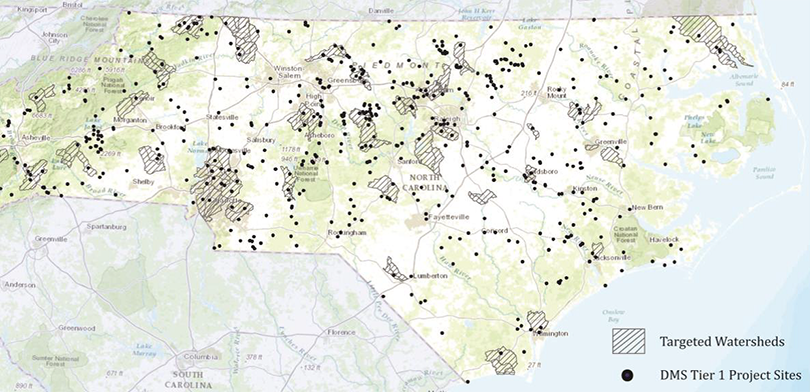
The Division of Mitigation Services uses a watershed planning approach to identify targeted local watersheds and prioritize the locations of mitigation projects for NCDOT and other developers. Source: NCDMS - Watershed Planning Map
NCDMS evaluates adverse impacts on aquatic resources across the State. They analyze both historic aquatic resource losses and current conditions through field studies. Measurements typically include water chemistry (e.g., nutrients, dissolved oxygen, pH), biological data (benthos and fish), and habitat assessments (in-stream and riparian habitat). Data analysis may also include land cover and aerial photography analyses to assist planners in determining threats posed to aquatic resources from forest conversion, poor riparian habitat, and increased impervious surface coverage.
Steps 5 and 6: Prioritize Actions & Develop a Crediting System
NCDMS activities have aligned particularly closely with Steps 5 and 6 of Eco-Logical. Step 5 involves creating a regional mitigation strategy and developing qualitative and quantitative valuation of mitigation sites. NCDMS uses aquatic resources and land use data to identify priority subwatersheds (30-150 sq. mi.), which are categorized based on land cover, governmental jurisdictions, pollution sources, and monitoring data. Subwatersheds with the greatest potential for improvement of functions (i.e., water quality, hydrology, and habitat) dictate where NCDEQ initiates a local watershed plan (LWP). LWPs receive funding priority when customers, such as NCDOT, submit a request for mitigation credits.
Mitigation Credit Precedents
Step 6 involves establishing habitat measurements, creating agreements for the use of offsite mitigation, and developing measurement of gains and losses of ecological functions associated with mitigation projects.
NCDMS uses information from its watershed planning processes (aligned with Steps 4-5) to establish baseline measurements of ecological function in each priority subwatershed. The ILF program accepts mitigation responsibility from NCDOT and other developers and then satisfies the mitigation permit requirements. NCDMS is solely responsible for mitigation outcomes.
NCDMS accepts mitigation responsibility of developers, including NCDOT, through receipt on an ILF payment, to offset impacts of a project.
| Credit Type |
Standard
In-Lieu Fee |
Private Bank Fee* |
| Stream (per linear ft.) |
$297 |
$350 to $376 |
| Riparian Wetland (per acre) |
$40,297 |
$34,000 to $67,000 |
| Non-Riparian Wetland (per acre) |
$26,445 |
n/d |
Mitigation Credit Cost Examples by Ecosystem Type
*NCDMS credit purchase and yearly survey of banks.
Source: NCDMS Fee Schedules.
Mitigation Agreements
Prior to 2003, the NCDOT and NCDEQ mitigation programs functioned independently with different operating processes, a situation which left many parties, including regulatory agencies and environmental interest groups, dissatisfied. Since 2003, three key agreements have helped to establish a successful mitigation process and crediting system in North Carolina:
- A 2003 formal Memorandum of Agreement among NCDOT, NCDEQ, and the USACE Wilmington District establishing the NCDMS.
- A 2008 agreement between NCDEQ and NCDOT detailing the key aspects of their mitigation relationship (superseded by a 2016 agreement).
- A legal instrument in 2010 between USACE and NCDEQ describing the operation and use of NCDMS’ ILF programs for stream and wetland mitigation.
Implementing Eco-Logical Steps 7-9
NCDMS also met some of the goals of Steps 7-9 of the Eco-Logical process through their activities that align with Steps 5 and 6.
Step 7:
NCDMS established formal mitigation agreements with NCDOT and USACE and an ILF instrument.
Step 8:
NCDMS developed an adaptive monitoring and management strategy for their ILF program and closely tracking mitigation commitments and performance measures.
Step 9:
NCDMS regularly updates their interagency agreements and mitigation strategies based on input from key stakeholders and new Federal and State regulations.
Compliance with Performance Standards
USACE, in conjunction with the IRT, ensures that NCDMS meets monitoring requirements and performance standards established by the 2008 Mitigation Rule and each project’s mitigation plan. For each potential mitigation site and project, NCDMS prepares and submits the following documents to the IRT:
- Conservation easement documents providing perpetual property/project protection.
- Site-specific mitigation plan for all proposed compensatory mitigation projects intended to meet the requirements of Section 404 and 401 of the Clean Water Act, Section 10 of the Rivers and Harbors Appropriation Act, and State water quality regulations.
- For each compensatory mitigation project, annual monitoring reports until success criteria defined in the mitigation plan have been met or the IRT determines that site monitoring can be discontinued (generally 7-year timeframe).
- Final report demonstrating that the mitigation project resulted in measurable restoration, enhancement and/or preservation of ecological functions.
Key Results & Findings
Using a landscape-scale approach, NCDMS and its partners developed the NCDOT Stream and Wetland ILF Program. Prior to the program, an estimated 70% of transportation projects were delayed due to a lack of sufficient compensatory mitigation and NCDOT alone was responsible for developing and administering a mitigation program.
Since 2001, collaboration and formal agreements among NCDOT, NCDEQ, and USACE have resulted in the following key accomplishments:
- A fully integrated watershed planning process that meets the intent of the 2008 Mitigation Rule
- Acceptance of an off-site, watershed-based compensatory mitigation model for transportation and other development projects that replaces function and value of lost aquatic resources
- Delivery of wetland, stream, and buffer compensatory mitigation credits with close to zero project delays associated with mitigation
- Greater cost certainty and increased benefits to ecosystems as a whole by compiling the mitigation needs of many small projects into large projects
Lessons Learned
Key lessons learned from NCDMS’ implementation of a landscape-scale approach include:
Flexibility offered by in-lieu fee programs.
Through the NCDOT Stream and Wetland ILF, mitigation is now identified and implemented prior to impacts associated with individual transportation projects, resulting in shorter permitting timelines and greater predictability regarding the success of mitigation activities. Prior to 2003, mitigation projects in North Carolina were generally completed concurrently or after adverse impacts to aquatic resources had already occurred.
Importance of building strong relationships.
Severe delays in permitting in North Carolina historically strained relationships between developers, such as NCDOT, and resource agencies. An interagency process improvement initiative increased trust among NCDOT, USACE, and NCDEQ and allowed NCDEQ to assume full liability and control over mitigation outcomes for transportation projects.
Value of compiling and consolidating data.
NCDOT initially relied on in-house planners, environmental staff, and outside consultants to collect ecological and land use data for individual projects. The creation of NCDMS provided a reliable targeted mitigation process that ensures NCDOT’s transportation improvement projects remain on schedule.
Next Steps
NCDMS and NCDOT will continue their use of a landscape-scale approach to compensatory mitigation and transportation project development. Some next steps related to how mitigation projects are targeted will include:
- Transition from spatial targeting to functional targeting.
Targeting mitigation spatially can make mitigation more expensive and does not always provide the greatest benefits to watersheds. NCDMS anticipates more measureable returns by targeting watershed functions on a catchment level.
- Develop a functional tool for watershed planning processes.
NCDMS plans to use this tool to evaluate replacement of functions in a particular watershed or basin, rather than identifying areas spatially. This will impact how mitigation is targeted and allow NCDMS to use funds as expediently as possible.
For More Information
Contacts
Tim Baumgartner
Division of Mitigation Services
Department of Environmental Quality
(919) 707-8543
Tim.Baumgartner@ncdenr.gov
David Williams
FHWA Office of Project Development and Environmental Review
(202) 366-4074
David.Williams@dot.gov

Resources

