Eco-Logical Successes
Fourth Edition | March 2013

 Prepared for:
Office of Project Development and Environmental Review
Federal Highway Administration (FHWA)
U.S. Department of Transportation
 Prepared by:
John A. Volpe National Transportation Systems Center
Research and Innovative Technology Administration (RITA)
U.S. Department of Transportation
Printer-friendly PDF (2.3 MB)
This document was funded by the FHWA's Office of Planning, Environment, and Realty's Surface Transportation Environment and Planning Cooperative Research Program (STEP).
Table of Contents
Introduction
Eco-Logical Program Update
Introduction
Infrastructure facilities, such as roadways, transit lines, and communication systems, provide vital services that support the healthy functioning of a community. While essential, sometimes the development of these facilities has negative environmental impacts. Past approaches to avoid, minimize, and mitigate adverse impacts on natural resources have not always provided sustainable environmental outcomes.
In 2006, an interagency steering team of eight Federal agencies created a process for developing infrastructure that is sensitive to terrestrial and aquatic habitats. This approach, documented in the publication Eco-Logical: An Ecosystem Approach to Developing Infrastructure Projects (Eco-Logical), encourages an integrated planning approach across agency and disciplinary boundaries and endorses ecosystembased mitigation.
Since signing the document, the eight signatory agencies have continued to promote the principles embodied in Eco-Logical. This edition of Eco-Logical Successes focuses on three agencies' programs that exemplify the Eco-Logical approach to infrastructure development:
- The Environmental Protection Agency's (EPA) Regional Ecological Assessment Protocol (REAP)
- The U.S. Army Corps of Engineers' (USACE) Watershed-Based Mitigation Approach
- The National Oceanic and Atmospheric Administration's (NOAA) Integrated Ecosystem Assessments (IEAs)
Back to top
Environmental Protection Agency's Regional Ecological Assessment Protocol
EPA's REAP is a practical tool to help agencies implement an integrated planning approach. Integrated planning, which seeks to coordinate the collection, sharing, and analysis of data among agencies and their planning processes, is the foundation of an ecosystem approach to infrastructure development.
The REAP is a planning and screening assessment tool that uses existing geospatial data to classify land on the basis of ecological importance. The REAP, which applies to the five States in EPA Region 6—Arkansas, Louisiana, New Mexico, Oklahoma, and Texas—uses eco-regions as its base unit of measurement. The REAP is comprised of 18 individual Geographic Information System (GIS) data layers, sourced from a variety of Federal and State agencies. The individual data layers are organized into three main layers:
- Diversity: shows land cover continuity (i.e. contiguous size of undeveloped land) and diversity.
- Rarity: shows the level of rare species and land cover types.
- Sustainability: describes the state of the environment in terms of stability and resistance to disturbance, such as roadways, urban/agricultural disturbances, and waterway obstruction.
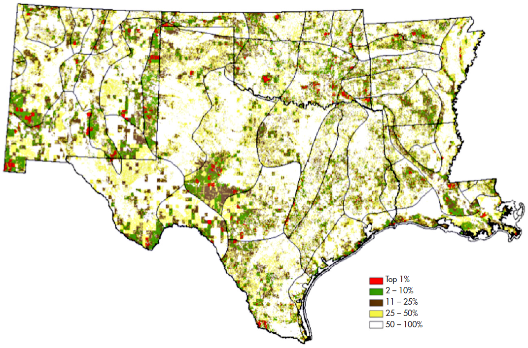
These three layers form a composite map that provides an overview of the ecologically significant areas for each of the 38 eco-regions in EPA Region 6 (see Figure 1). The important ecological areas are those that represent the intersection of the top one percent for diversity, rarity, and sustainability.
Because REAP analyzes ecological resources across a regional scale—and thus across jurisdiction boundaries—it is an effective tool to help agencies identify priority ecological areas for projects that span more than one jurisdiction. By using the REAP information during the planning process, agencies can design projects that avoid ecologically significant areas, to the extent possible. When avoidance is not possible, agencies can also utilize the REAP information to identify mitigation approaches that serve the highest ecological need.
EPA has integrated REAP into two of its broader screening tools—the GIS Screening Tool (GIS-ST) and NEPAssist—in order to expand accessibility and use of the data. GIS-ST, primarily used by the Texas Department of Transportation, is a GIS-driven environmental assessment and data management tool used to identify and map environmental concerns within a project area. Similarly, NEPAssist, which draws environmental data from EPA databases, enables planners to screen a geographic area for potential environmental issues. Both tools streamline the review process by helping agencies identify important environmental issues at the earliest stages of planning and project development.
Field Implementation
State and local agencies throughout EPA Region 6 use the REAP during planning and project development. The North Central Texas Council of Governments (NCTCOG), the Metropolitan Planning Organization for the Dallas-Fort Worth area, considered the REAP data in developing its long range transportation plan, Mobility 2035. The REAP data was used as part of the environmental scoring conducted for each transit and roadway recommendation. Planners rely on these scores to help identify key environmental resources that require additional review during the project-level planning process.
For more information on EPA's REAP tool contact Sharon Osowski Morgan, Ecologist/Environmental Scientist at osowski.sharon@epamail.epa.gov.
Figure 1: REAP Composite Map
(Source, EPA, REAP Project Report)

The composite map categorizes areas by level of ecological importance.
Areas in red, i.e. those in the top 1 percent, represent those of highest ecological importance.
Back to top
U.S. Army Corps of Engineers Watershed-Based Mitigation Approach
The USACE provides vital public engineering services in peace and in war to strengthen the Nation's security, energize the economy, and reduce risks from disasters. USACE regulates the discharge of dredged or fill material within waters of the U.S., including wetlands, under Section 404 of the Clean Water Act (CWA). When there is a proposed discharge, a project sponsor must first take all appropriate and practicable steps to avoid and minimize impacts to aquatic resources. For unavoidable impacts to waters of the U.S., compensatory mitigation may be required to replace the loss of wetland, stream, and/or other aquatic resource functions. The USACE determines the appropriate form and amount of compensatory mitigation required in accordance with its regulations at 33 C.F.R. Part 332.
In the past, USACE evaluated compensatory mitigation proposals on a project-by-project basis and typically required mitigation measures on, or adjacent to, the impact site. In recent years, scientific research has demonstrated that this on-site, in-kind mitigation does not yield the greatest benefit to an ecosystem. In contrast, a watershed-based mitigation approach takes a broader, ecosystem-based view of compensating for impacts of infrastructure projects. This approach is more effective at providing mitigation with a higher likelihood of success and benefit for ecosystems, habitats, and wildlife.
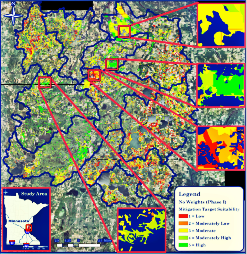
Figure 2: Sunrise River Watershed Mitigation Site Suitability Analysis
(Source: Engineer Research and Development Center (ERDC), Map developed by Kelly A. Burks-Copes, ERDC)

The map depicts the suitability of sites for compensatory mitigation activities (areas in red represent sites of low suitability; those in green are high suitability sites).
The USACE currently participates in a number of efforts in support of a watershed-based approach to developing wetland compensatory mitigation. These efforts range from more formalized, complex studies and regional planning efforts to smaller-scale, less resource intensive analysis of regional stressors, land use, and natural resources. Regardless of the scale, all efforts seek to identify preferred types and locations for compensatory mitigation within a defined watershed area.
Field Implementation
In June 2009, the USACE St. Paul District initiated a watershed-based mitigation pilot study for the Sunrise River watershed. The 383 square-mile Sunrise River watershed in Minnesota includes two major transportation corridors – Interstate 35 and U.S. Highway 8. The purpose of the study was to develop a GIS-based tool to assist regulators and stakeholders with identifying, prioritizing, and selecting compensatory mitigation sites in a proactive, holistic manner.
The USACE developed an interactive, spatially-based decision support system called SWAMPS (Spatially-explicit Watershed-based Approach to Mitigation Positioning and Selection) that screens for potential compensatory mitigation targets across the watershed. The USACE collected existing geospatial data from Federal and State agencies to assess the watershed's condition. Working with its partners in the watershed, the USACE developed a set of ten mitigation site selection criteria—including hydrologic connectivity, biodiversity, and land costs—and assigned ratings and weights based on the importance of each criterion. The suitability criteria and associated weightings were combined to produce maps that locate and prioritize sites suitable for compensatory mitigation activities (see Figure 2).
Agencies utilize the results of the watershed-based mitigation site suitability analysis, developed using SWAMPS, to identify opportunities to fulfill compensatory mitigation requirements. USACE will produce a final report outlining the pilot study methodology and results in 2013.
In addition to the Sunrise River study, USACE is participating in several other watershed-based mitigation pilot studies across the nation. Planning studies are underway in California, Colorado, Georgia, Maryland, Tennessee, and Wisconsin. For more information on USACE's watershed-based mitigation approach contact Lauren Diaz, Program Manager/National Transportation Liaison, at Lauren.B.Diaz@usace.army.mil.
Back to top
NOAA's Integrated Ecosystem Assessment Approach
NOAA established the Ecosystem Assessment Program (EAP) to enable more comprehensive and holistic management of coastal and marine ecosystems. The program takes an integrated approach to monitoring and assessing marine ecosystems and their associated Living Marine Resources. The EAP collects observation data; conducts assessments of fisheries, protected species, and habitats; and develops forecasts for future conditions. The program's data, assessments, and forecasts are used to make ecosystem-based management decisions.
As part of the EAP, NOAA is developing Integrated Ecosystem Assessments (IEAs), regional decision support systems that provide the scientific basis for ecosystem-based approaches to managing marine resources and services. The IEAs provide resource managers with ecosystem-specific information to make more cost-effective and informed resource management decisions.
IEAs are intended to involve and inform citizens, industry representatives, scientists, resource managers, and policy makers about key ecosystem components and pressures. They provide an efficient, transparent means of summarizing the status of ecosystem components, screening and prioritizing potential risks, and evaluating alternative management strategies against a backdrop of environmental conditions. IEAs evaluate cumulative effects of multiple ocean uses, such as fishing, coastal development, pollution, shipping, and oil and gas extraction, and the interactions between these uses.
The IEA approach includes many of the same elements outlined in Eco-Logical's eight-step framework for integrating interagency planning efforts. Both approaches start with developing a collaborative culture and continue by looking at ecosystem impacts in a holistic manner. Each approach endorses adaptive management as a way to ensure that actions continue to achieve desired results.
NOAA's IEA approach includes the following five steps:
- Scoping – Stakeholders, resource managers, and policy makers from NOAA, other Federal agencies, States, and nongovernmental organizations review existing documents and information to identify management objectives, ecosystem attributes of concern, and stressors relevant to the ecosystem being examined.
- Indicator identification and testing – Researchers develop and test indicators that reflect the ecosystem attributes and stressors.
- Risk Analysis – Researchers evaluate the risk to the indicators posed by human activities and natural processes.
- Integration – Researchers integrate results from the risk analysis into an overall assessment that quantifies the status of the ecosystem relative to the historical status and prescribed targets.
- Monitoring and Evaluation – Stakeholders develop a formal Management Strategy Evaluation (MSE), a simulation model, to evaluate the potential for different management strategies to influence the indicators. The MSE simulates the full management cycle, testing the utility of modifying indicators, assessments, monitoring plans, management strategies, and decision rules, and it serves as a filter to identify which methods meet stated management objectives.
The IEA process is repeated in an adaptive manner. Continual monitoring of ecosystem indicators enables managers to determine whether or not management strategies are successful and to revise approaches as needed.
Field Implementation
NOAA is currently conducting IEAs in five of the nation's eight large marine ecosystems: the California Current, the Gulf of Mexico, the Northeast Shelf, Alaska, and the Pacific Islands. The remaining three regions (the Southeast Shelf, the Caribbean, and the Great Lakes) will follow as program capacity grows.
In addition to the large marine ecosystem IEAs, a number of other IEA efforts are underway across the U.S. For example, the Puget Sound Partnership (PSP), a public-private entity comprised of citizens, governments, tribes, scientists, and businesses, are employing an IEA to improve the health of Puget Sound, Washington. The PSP worked with the community's diverse members to develop an action agenda that outlines specific strategies and actions to restore the Puget Sound. The action agenda includes strategies aimed at 1) preventing pollution from urban stormwater runoff; 2) protecting and restoring habitat; and 3) recovering shellfish beds. Transportation related strategies include stormwater retrofit and mitigation projects and floodplain restoration projects.
As part of the action plan, the PSP developed ecosystem recovery targets and created a science-based assessment of the expected ecological impact of each group of strategies in the action plan. In order to monitor the effectiveness of the action plan, the PSP is building a performance management system that will enable them to evaluate actions against the defined ecosystem targets.
For more information on NOAA's IEAs, contact Michael Tust, Fishery Biologist, at Michael.Tust@noaa.gov.
Back to top
FHWA's Eco-Logic Program Update
FHWA continues to advance implementation of the Eco-Logical approach by working with transportation, resource, and regulatory agencies. As part of the Second Highway Research Program (SHRP2), in September 2012, FHWA worked with the Transportation Research Board (TRB) and the American Association of State Highway and Transportation Officials (AASHTO) to conduct a workshop for implementing the Eco-Logical framework on a national scale. The workshop featured a panel of experts and stakeholders representingState DOTs, MPOs, Federal resource and regulatory agencies, professional associations, and nongovernmental organizations to develop recommended strategies and tactics for Eco-Logical implementation.
The workshop resulted in an action plan with recommended implementation tactics across six strategy areas:
- Strategy 1: Educate agency leadership about the value and benefits of the ecosystem-scale approach to gain support for implementation activities.
- Strategy 2: Develop incentives or support for state and regional transportation agencies to adopt a Regional Ecosystem Framework (REF) or integrate elements of the Integrated Ecological Framework (IEF) into standard procedures.
- Strategy 3: Provide technical assistance to educate staff-level practitioners about techniques and tools for implementing Eco-Logical and provide opportunities for target audiences to learn from their peers.
- Strategy 4: With input from the user community, develop a business case highlighting the time and cost savings associated with the Eco-Logical approach.
- Strategy 5: Develop new tools and technologies that increase and/or enhance access to existing data and support interagency collaboration.
- Strategy 6: Develop communications and outreach materials to increase awareness about Eco-Logical and facilitate information sharing among potential users.
Over the coming months, FHWA will continue to work with AASHTO, TRB, and the other Eco-Logical signatory agencies to move the implementation strategies forward.
Back to top

