CASE STUDIES
Colorado: Strategic Transportation, Environmental, and Planning Process for Urban Places
Agencies and Organizations Involved
- Federal Highway Administration (FHWA)
- U.S. Environmental Protection Agency (EPA)
- U.S. Fish and Wildlife Service (USFWS)
- U.S. Army Corps of Engineers (USACE)
- U.S. Department of Transportation (USDOT)
- North Front Range Metropolitan Planning Organization (NFRMPO)
- Colorado Department of Transportation (CDOT)
- Colorado State Historic Preservation Office
- Colorado Division of Wildlife
For additional information, please contact Suzette Mallette, NFRMPO Regional Planning Manager, at (970) 416-2257 or SMallette@nfrmpo.org.
Section 1: Overview
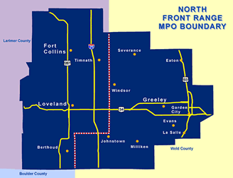
Colorado’s Strategic Transportation, Environmental, and Planning Process for Urban Places (STEP-UP) is an environmental streamlining pilot project aimed at integrating environmental considerations into transportation planning. STEP-UP is a partnership of CDOT, FHWA, EPA Region 8, and NFRMPO. The STEP-UP process applies to the NFRMPO planning region, covering 1,600 square miles and approximately 380,000 residents.1 The NFRMPO area spans north of Denver to the Fort Collins metropolitan area, up the I-25 corridor (see figure 1).
Figure 1: Map of NFRMPO and surrounding areas
STEP-UP responds to section 139 of the Transportation Equity Act of the 21st Century (TEA-21), promoting expedited and integrated environmental review processes for transportation projects.2 The State of Colorado was interested in linking planning and NEPA projects more tightly under its own directives.3 In response, NFRMPO, CDOT, and FHWA‘s Colorado Division office began discussing ways to identify and address environmental considerations earlier in the planning process. Geographically, the North Front Range area was a good choice, due to its moderate size and rapidly growing urbanized areas.4 In addition, NFRMPO was a perfect candidate because of its interest in these linkages, technical capabilities, and data resources. The MPO had very good relationships with its local jurisdictions and pursued guidance from FHWA and CDOT for better integrated planning processes. Technically, the MPO had established in-house travel demand and land use modeling capabilities as of 2000. Supplementing its technical tools, CDOT had recently completed an extensive EIS for the North I-25 project, covering most of NFRMPO’s jurisdictional corridors, meaning data availability would be less of an issue.
STEP-UP improves evaluation of a project’s environmental issues in the regional planning process, engages full and early participation of all relevant agencies, improves the NEPA decision making process, and informs the local project prioritization process. The pilot project had three phases.
Phase 1 was completed in early 2005. It identified the STEP-UP project goal and its implementation process, including:
- An improved process and methodology for addressing environmental impacts related to transportation projects at the earliest possible stage
- GIS-based tools for identifying the impacts of transportation projects and plans early on
- A Regional Cumulative Effects Assessment process for NFRMPO’s Regional Transportation Plan to help understand the effects of transportation development on land use and the environment.5
Phase II involved creation of an environmental GIS Web-based application, including data gathering and pilot testing from November 2006 to April 2007. CDOT planned to use this pilot to prepare for eventual statewide implementation. NFRMPO also prepared to use this environmental screening in its transportation planning process to begin in 2007. 6
In Phase III, NFRMPO is presently using STEP-UP in its transportation planning process, due at the end of 2007.
STEP-UP ultimately will result in a model planning process for identifying environmental issues early in development of the long-range regional transportation plan ; ensuring early and continued involvement by resource agencies ; creating a better link between transportation, environmental, and land use planning ; and implementing transportation improvements that protect the environment, enhance quality of life, and promote community values.7 STEP-UP’s additional/supplemental goals include improving the local project prioritization process and initiating the regional cumulative environmental assessment framework.
Integrated Planning Applications
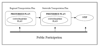
Colorado’s statewide transportation planning is the overarching structure in which STEP-UP, the modified process, operates. In 1991, the Intermodal Surface Transportation Efficiency Act (ISTEA) revised titles 23 and 49 to require States to prepare a Statewide Transportation Plan (STP) and Statewide Transportation Improvement Program (STIP). State legislation designated CDOT as the agency to address all modes of transportation in Colorado at the State, regional, and local levels. CDOT has 15 Transportation Planning Regions (TPRs), one of which is NFRMPO. The TPRs now develop their own Regional Transportation Plans (RTPs), which require attention to multi modalism and greater public participation during plan development.8 CDOT and the statewide Transportation Advisory Committee review the R T P s and integrate them to create Colorado’s STP for the 20-year horizon. Each TPR/MPO is on the same cycle, meaning all RTPs are created and submitted to CDOT concurrently approximately every 4-5 years.9 Using the STP and RTPs, CDOT and NFRMPO prepare the STIP, which contains a list of specific, near-term (4-6 years) transportation improvement projects. Though not a Federal requirement, The STIP contains each MPO’s Transportation Improvement Program (TIP), which is a list of fiscally constrained, near-term projects prioritized by the MPO. After the MPO funds specific projects they are listed on the TIP, and CDOT moves to bidding and construction (see figure 2).
Figure 2: A process flow chart showing Colorado’s STP process10
Within this statewide structure, NFR MPO has its own process, generally consisting of the following steps:
- Call for Projects: Local governments and CDOT submit projects for consideration in the RTP.
- Project Prioritization Process: Projects submitted are reviewed for eligibility, including regional significance, and are then categorized, evaluated, and ranked. Previously, no environmental criteria were included as part of this process.
- RTP Development: If a project is eligible, the Planning Council approves it for inclusion in the RTP. The RTP consists of a Vision Plan and Fiscally Constrained Plan. Ultimately, NFRMPO’s RTP is incorporated into the STP. The RTP is updated every 4 years and includes a vision and goals, an opportunity for public component, inventory of the existing transportation system, socio-economic and demographic profile, travel demand model, mobility demand analysis, corridor visioning, project identification, preferred or vision plan, and the final adopted plan.
- Prepare TIP : The TIP presents a 6-year schedule of multi modal projects from the fiscally constrained portion of the RTP. The TIP is updated at least every 4 years and must show conformity with the Colorado State Implementation Plan for air quality. The TIP is incorporated into the STIP. A project included in the STIP is eligible for State and Federal funds and, based on its priority, moves into project development and implementation. 11
Figure 3: Modified planning process showing STEP-UP and environmental elements12
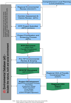
Figure 4: Similarities in corridor planning and the NEPA process13
Within both the State structure and the steps immediately above, STEP-UP is the environmental modification to the current planning process discussed above. The new integrated and modified process is highlighted below (see figure 3):
Step 1-Regional environmental review. Under STEP-UP, NFRMPO developed specific environmental metrics and engaged resource agencies during preparation of the long-range transportation plan. Resource agencies review environmental data via an on line, GIS-based tool and assist NFRMPO in identifying environmental issues associated with wide transportation corridors rather than looking at specific projects. Early involvement of the resource agencies allows early identification of critical environmental issues and avoidance of issues that can become fatal flaws at the project level. Participation of resource agencies in development of corridors and corridor visions also helps them to better prioritize projects for more detailed or targeted review. For example, if the agencies know in advance that a large project is located in an environmentally sensitive corridor, and they know the potential environmental issues within that corridor, they can plan accordingly and become involved at the corridor stage. Overall, the resource agencies were very pleased with the STEP-UP process.
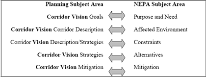
Step 2-Corridor assessment and visions review. Each region must identify significant transportation corridors and determine the visions, goals, and strategies for each corridor. A corridor is a transportation system that includes all modes and facilities within a geographic area described by length and width. NFRMPO developed visions for each of its proposed corridors that included environmental goals and objectives, in addition to transportation needs and strategies. The corridors are I-25, US 287, and US 34 (see figure 1). NFRMPO intentionally designed the environmental goals and objectives to be consistent with the goals, strategies, and missions of the resource agencies with major roles in transportation project development and the environmental review process. Environmental criteria are also used quantitatively as one of several metrics to prioritize corridors, determining which corridors should be advanced to the next phase of planning and project development. Figure 4 shows the parallel nature of corridor planning and the NEPA process.
Step 3-RTP project submittal. Local jurisdictions within NFRMPO develop projects for inclusion in the RTP. The local jurisdictions use the environmental database to determine alignments and preview environmental clearances that may be required. Jurisdictions can also more accurately determine project costs by avoiding environmentally sensitive areas or limiting impact.
Step 4-Project prioritization and screening process. Projects submitted by the local jurisdictions are reviewed and scored using a GIS tool developed by STEP-UP to include environmental layers. The previously identified environmental issues are used by CDOT to develop specific projects in a more environmentally sensitive manner, given the environmental context in the corridor.
Step 5-RTP document. NFRMPO prepares the RTP document every 4 years. The RTP contains a list of long-term, multi modal transportation needs and a list of shorter term, high- priority projects. Projects must be consistent with the vision of the corridor where they are located. Prior to STEP-UP, the planning process did not provide a quantitative means of considering environmental data, nor did it provide a venue for resource agency input. However, now STEP-UP provides member governments with evaluative environmental data for both transportation and land use planning.
Step 6-Pre-TIP environmental review and scoping. CDOT, FHWA, resource agencies, and project sponsors conduct a more detailed environmental review of the top projects on the RTP prior to moving them on to the TIP. The review includes determination of the appropriate NEPA class of action for each project, identification of resource agencies, development of purpose and need, and determination of environmental/NEPA cost considerations. Many of these decisions are informed both by the public processes in the previous steps and the STEP-UP database.
Step 7-TIP/STIP document. NFRMPO prepares a list of projects for the next 6 years, updating the list at least every 4 years. TIP projects are integrated into the STIP to be eligible for State and Federal funding.
Step 8-Project Development. Specific projects are scheduled for bid letting and construction. For each selected project, the NEPA process is completed and the project is designed.
Section 2: Data and Tools
The STEP-UP process resulted in a good understanding of the various roles and responsibilities of all involved.
– Rena Brand, U S A CE
The STEP-UP program itself is an innovative tool. The GIS tool/database is a non proprietary, interactive, on line GIS database application, populated with many different data resources to support the modified planning process. The entire planning process is captured through STEP-UP.
Through several meetings in October-December 2004, the STEP-UP Steering Committee and its work groups created the GIS STEP-UP platform design. Participants in these meetings included staff from the consultant, representatives of the agencies on the Steering Committee (CDOT, FHWA, EPA Region 8, and NFRMPO) and volunteers from other agencies that might be involved in STEP-UP’s future initiatives. The Steering Committee agreed on three design objectives for the STEP-UP GIS program. The program should:
- Represent each step in the modified planning process in figure 3, with one or more user-friendly application interfaces. The interfaces must be accessible by Steering Committee members and applicable resource agencies.
- Provide dynamic mapping of environmental issues, proposed projects, and transportation planning corridors.
- Produce a reusable database of projects and environmental data to ensure that the data produced through this application will be available across planning efforts or planning cycles.14
The STEP-UP GIS program maximized this user-friendliness and accessibility.
From a technical standpoint, the Steering Committee made several decisions regarding the primary delivery platform, specific development standards enforced by CDOT, and data management. CDOT standards were used in the design of the application and were the initial host of the GIS program. The only requirements of use were a standard Web browser, such as Microsoft Explorer, and Internet connectivity. Later, the pilot application was created using Microsoft.NET. All of the GIS components are hosted in the CDOT system, and thus do not require individual user licensing or additional elements.15 The program also uses an Oracle database, folding that relational database capability into the GIS component (ArcSDE-Spatial Database Engine). All environmental data are GIS-based or Oracle-based for data standardization. This structure allowed for the greatest ease of use.
Two important factors must be considered when constructing a GIS database for an integrated planning initiative like STEP-UP:
- Data quality and level of detail-Using data from many different sources means substantial variations in quality and resolution of the data. The level of detail covered by different data sets varies considerably. For example, National Wetland Inventory mapping data is sufficient for constraint mapping, but not for NEPA permits.
- Data security and access-Some data sets used to integrate planning and environmental considerations are considered sensitive and are subject to security measures and access rights. Data related to location and content of archaeological sites falls into this category. Archaeological sites are often vandalized and looted, so spatial data related to their locations must be limited.
The Steering Committee wanted to include these different layers in the GISdatabase:
- Floodplains
- Watersheds and hydrologic units, including impaired waters
- Wetlands
- Waters of the United States
- Dams and impoundments
- Threatened and endangered species
- Critical habitat and migration corridors
- Game species habitat
- Hazardous waste sites
- Abandoned mines
- Oil/gas wells
- Section 4(f) resources including parks, recreation areas, and wildlife refuges (no historic resources)
- Existing land use
- Existing zoning
- Future land use
- Urban growth boundaries
- Regional roadway network
- Air quality status
- Socio-economic census data
- Farmland
Much of this data was collected during the North I-25 Environmental Impact Statement (EIS).16 However, some of these mapping layers were incomplete, including:
- Historic resources
- Additional hazardous materials data
- North Front Range land use layer
- Soil data for identification of farmlands
- Wildlife data in addition to threatened or endangered species
Additional sources included the different resource agencies and the University of Colorado. To facilitate expansion of the GIS database, CDOT requires consultants working on transportation projects to provide electronic data sets of environmental information collected during Environmental Assessments (EAs), EISs, and other environmental studies.
After a pilot version of the GIS database was created on the Internet, the Steering Committee tested its functionality for use, and then its informational resources. Following the kick off meeting for the pilot, participants were given 3.5 weeks in December 2006 to submit electronic comments on the environmental data layers and the NFR corridors (I-25, US 287, and US 34).17 One example of the database’s strong interface was given in the Phase II report:
A user could create a comment that indicates that all wetlands of a certain type should be classified at a certain level of constraint (low, medium, or high). An exception to this rule could be created through an additional comment that selects one or more features from the wetland layer and indicates that the level of constraint should be higher than indicated by the first comment. The resource agency user will be able to track the data administrator’s progress in resolving these comments through the same interface. Each user would only be able to provide this type of comment and direction on layers assigned to their agency. 18
Most of the comments and issues were resolved. Overall, participants were pleased with the STEP-UP product. Any remaining issues revolved around the missing data layers. These layers were not included in Phase III testing of the GIS program for the NFRMPO test, presently occurring for its RTP 2035. Outside of the initial $250,000 Federal grant, there are no plans to maintain the STEP-UP database. In fact, CDOT has switched from a.NET-based system to a java-based system, meaning STE P-UP will not be replicated in its current form. CDOT has a similar parallel effort called GeoMap under this system. GeoMap can use the STEP GIS data but has a different user interface. The STEP-UP GIS program will not continue past this current RTP cycle for NFRMPO.
Section 3: Scheduled Cooperation and Interaction Processes
Development of STEP-UP took place from 2003 to 2007. Initially, meetings with all participating agencies were held at least once per month. Once the process was underway, meetings occurred once every 6 months. Communication also took place informally through phone calls and e-mails. A steering committee composed of staff-level representatives from NFRMPO, CDOT, EPA, FHWA, USACE, and USFWS attended these meetings.
Interagency cooperation and participation is a critical aspect of STEP-UP. Recognizing some of the benefits of STEP-UP and participating in the long-range transportation planning process, each resource agency voluntarily dedicated a staff member who could participate in the STEP-UP meetings and provide input on the initiative.
At the outset of the STEP-UP meetings, few members of the planning group were well versed in both the NEPA and transportation planning processes. However, regular meetings and communication laid the groundwork for increased understanding of both processes and responsibilities.
Section 4: Legal Framework
STEP-UP is a completely voluntary process. NFRMPO and other STEP-UP participants discussed the possibility of developing memoranda of understanding (MOU), but decided it was not necessary due to the small, regional scale of the STEP-UP pilot project. A formal interagency agreement such as an MOU will be needed if STEP-UP is adopted at a statewide level.
Section 5: Leadership Role
CDOT and NFRMPO took strong leadership roles in working with resource agencies and arranging meetings. Both these agencies were also supported by consultants for project development of STEP-UP, funded through the FHWA grant. Interested resource agencies were involved in a steering committee that helped to guide the process and methodology. The steering committee was composed of representatives from CDOT, EPA, FHWA, and NFRMPO. The committee also formed work groups to address specific areas related to development of STEP-UP: Cumulative Effects, Planning, Data Repository, and Tools. Members of the steering committee, the consultants, and staff from other stakeholder agencies participated in these workgroups.
Section 6: Funding Sources and Liaisons
In July 2003, FHWA’s Colorado Division office distributed $250,000 in FHWA funding for the STEP-UP pilot project.19 NFRMPO used a phased approach for the STEP-UP project, completing Phase I (Project Development) and Phase II (Project Testing) with the funding provided. Phases II and III would have been integrated as part of NFRMPO’s long-range transportation planning if additional funding had been available in the future.
While NFRMPO hired consultants using the FHWA funds, no additional hires were made by any of the participating agencies. Agency staff voluntarily shifted workloads to participate in the STEP-UP process.
Section 7: Performance Measures and Outcomes
STEP-UP does not have a standard/formalized performance measurement system in place. None of the Steering Committee agencies are using performance measures related to this pilot project as well.
Section 8: Lessons Learned
- Data management. Data management is a critical component of an information-based decision making process such as STEP-UP. This management includes standardizing, storing, and updating data. This issue would have been especially difficult for Phase III of STEP-UP since it expands the scope of the data management effort and involves greater commitment to making data available.
- Understanding agency roles and responsibilities. Understanding agency roles and responsibilities is important for managing expectations, ensuring process predictability, and ensuring inclusion of the most accurate data. A USACE representative found that group discussions were helpful for educating participating organizations about each other. Prior to the STEP-UP process, some of the organizations had seldom worked with each other. USFWS representatives commented that STEP-UP was proactive and cooperative, and could be easily transferred to other jurisdictions.
- Creative methods. Innovative methods can be used to obtain missing data. For example, data from an ongoing EIS were used in conjunction with other environmental data available from resource agencies and entities, such as the University of Colorado. To facilitate expansion of the GIS database, CDOT is requiring consultants to provide electronic data sets of all environmental information collected during transportation EA s, EISs, and other environmental studies.
- Early and in depth agency participation. Early agency participation has been key to STEP-UP’s success. Resource agencies review environmental data via an on line, GIS-based tool, and help NFRMPO identify environmental issues related to wide transportation corridors rather than look at specific projects.
1 https://nfrmpo.org/faq/
2 Section 139 of TEA-21 called for a coordinated environmental review process by which USDOT would work with other Federal agencies to ensure that major highway and transit projects are advanced according to cooperatively determined timeframes. In addition, section 139 emphasized concurrent reviews, mandated creation of a dispute resolution process between USDOT and other Federal agencies, allowed States the option of including their environmental reviews in the coordinated environmental review process, and authorized the USDOT Secretary to approve requests to reimburse Federal agencies for expenses associated with meeting expedited time frames.
3 Linking Planning and NEPA report. See guidance at https://www.codot.gov/programs/environmental/planning-env-link-program.
4 MacDonald, T. and P. Lidov. May 2005. STEP-UP Phase I Report. Report No. CDOT-DTD-2005-03. Available on line at https://www.codot.gov/programs/research/pdfs/2005.
5 MacDonald
6 “STEP-UP Phase II: Final Report for Input to NFRMPO 2035 Regional Transportation Plan.” Prepared for NFRMPO, CDOT, and FHWA by Carter Burgess. April 2007.
7 MacDonald
8 MacDonald
9 Depends on air quality attainment. Federal regulations require 4-year updates for those in nonattainment, 5 years for others. However, Colorado tries to keep all TPR s and MPOs on the same schedule, so these TPR s are encouraged to update at the same time as the nonattaiment areas.
10 Opperman, Yates. Linking Planning and the National Environmental Policy Act. March 2007. Available through CDOT.
11 MacDonald
12 Phase II Report p.2
13 Opperman
14 Phase I Report p. 34
15 GIS mapping for Web-based applications is based on ESRI’s Arc Internet Mapping Server (ArcIMS). ArcIMS provides extensions to the Web server so that maps can be included in Web pages provided to end users.
16 Phase II Report p. 3
17 Phase II Report p. 3
18 Phase II Report p. 3
19 Phase I Report p. 1

