SHRP2 C19 Expediting Project Delivery

Expediting Project Delivery

Constraints

Strategies

Meetings and Conferences

Webinars

Library

Contact Us
Applying Expediting Project Delivery (C19) in Massachusetts
View Printer-friendly PDF ➤
SHRP2
Case Studies Series
Expediting Project Delivery (C19)
Speeding up the delivery of transportation projects is high on everyone’s agenda. Expediting Project Delivery (C19) was developed through the second Strategic Highway Research Program (SHRP2) to provide innovative approaches to the planning process to produce better projects and environmental outcomes while addressing the common constraints encountered during project implementation.
These strategies save time, reduce the need for rework, reduce the risk of unanticipated permitting and mitigation costs, and provide a framework for resolving disputes.
The C19 framework includes:
- Twenty-four proven and effective strategies that focus on planning, National Environmental Policy Act (NEPA), and permitting phases of project development and delivery
- These strategies address 16 common obstacles to meeting project schedules, reducing risk, and building strong collaboration.
Twelve state departments of transportation are now implementing Expediting Project Delivery through the SHRP2 Implementation Assistance Program. This case study documents activities underway in the Massachusetts Department of Transportation (MassDOT) to maximize efficiency of planning and approvals.
Massachusetts Department of Transportation Uses Expediting Project Delivery (C19) SHRP2 Solutions to Develop Planning/Approval Map App
Early, effective communication of environmental and project information through mapping helps speed project planning and approval
Transportation project planning requires complex coordination between internal departments and external stakeholders to address multi-agency requirements. These departments and agencies often require customized information that may be drawn from several separate and distinct environmental, asset, and project databases.
The Massachusetts Department of Transportation (MassDOT) recognized the need to improve collaboration during planning, specifically by developing better scopes of work, more accurate construction estimates, enhanced early environmental coordination, and more streamlined permitting. To facilitate the planning and environmental review linkage, and expedite internal and external review and decision-making, the department is developing the MassDOT Project Intake Tool (MaPIT), a user-friendly, online project-planning application.
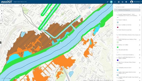
MaPIT as a GIS screening tool.
Funded through Round 2 of the SHRP2 Implementation Assistance Program, MassDOT is working to map all new projects at the planning stage and is developing a
GIS
data and document sharing application (app), called the Project Intake Tool. The development of this tool was a result of MassDOT selecting the following four Expediting Project Delivery strategies to implement for their planning program:
- Strategy 8 – Expedited internal review and decision making
- Strategy 14 – Planning and Environmental Linkages
- Strategy 15 – Planning-Level Environmental Screening Criteria
- Strategy 19 – Regional Environmental Analysis Framework
Instead of building complicated and custom systems, MaPIT seeks to break down the processes into components and align those components with location-aware apps. These apps are targeted to stakeholder groups or even individuals. They are simple to use, relevant, and as accessible as apps on smartphones. Minimal training or reading of a manual will be required to operate the app.
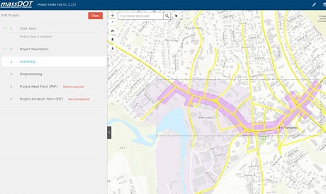
MaPIT expedites project initiation and delivery.
MassDOT’s location-based MaPIT app facilitates environmental and safety screening and improves agency coordination
MaPIT will provide a web-based user interface to be used during online project initiation and analysis to conduct planning phase environmental, safety, and vulnerability screening. As such, spatial analysis and project editing will be integrated into planning. Users will be able to create and map the project during project planning, conduct spatial analysis and project editing, and then export and submit the project for approval. The app is integrated through a GIS platform to the system of record; the app then keeps the system of record updated with accurate and current data. The map-centric approach will be used to generate, score, cost, and submit transportation projects.
The system uses Esri’s Roads and Highways linear referencing system (COTS) and leverages North Carolina Department of Transportation’s SPOT Online Planning System. Additionally, MassDOT established a Regional Environmental Framework through an agreement with state and federal resource and regulatory agencies to help guide project scope development.
The app will allow for more detailed scopes of work and planning systems that address MassDOT and agency:
- Conservation priorities, restoration opportunities, and ecological requests (such as for aquatic organism passage, wildlife accommodation, rare species considerations, tidal restriction alleviation)
- Adaptation considerations (GreenDOT goals and climate change/vulnerability studies)
- Permitting requests
- Safety considerations (such as crash clusters)
- Vulnerability considerations (roadways, stream crossings; retaining walls; side slopes; landslide prone areas; flood prone transportation assets
MaPIT utilizes regional ecosystem and environmental framework that integrates the state conservation data and plan (BioMap2) into the app. The maps will provide a variety of data including wildlife management areas, roadside endangered species habitat, and rare wetland communities. Site-specific information will include conservation data (such as diadromous fish restoration, cold water fisheries, wildlife mortality hotspots, restoration opportunities), aquatic connectivity priorities (such as diadromous fish passages; stream crossings/resiliency/restoration opportunities), and terrestrial connectivity priorities. This data can be used during project planning to conduct connectivity priority modeling and identify wildlife infrastructure improvements. The result is early incorporation of environmental data promoting contextsensitive designs that expedite future regulatory approvals.
“MassDOT is leveraging its expanded asset data, along with mapping technology, to better inform planners and engineers and improve the project delivery process.”
- Patricia A. Leavenworth, P.E.
Chief Engineer – MassDOT
Benefits of Expediting Project Delivery
- Allows for multi-issue coordinated planning
- Provides real-time data by integrating multiple-agency geospatial information
- Improves inter-agency coordination – planning phase agency review/comment capability
- Facilitates developing design and analysis recommendations and initial construction estimates
For more information on MassDOT’s effort to implement Expediting Project Delivery, contact Michael Bolduc at Michael.Bolduc@state.ma.us or call 413.582.1528.
For information on the SHRP2 implementation of Expediting Project Delivery, contact David Williams at FHWA, David.Williams@dot.gov or call 202.366.4074 or Kate Kurgan at
AASHTO, KKurgan@aashto.org or call 202.624.3635.

