Instructions for Reviewing Travel and Land Use Forecasting Analysis in NEPA Documents
February 21, 2018
Introduction
What is the purpose of this document?
The purpose of this document is to support review of travel and land use forecasting elements of documents prepared pursuant to the National Environmental Policy Act (NEPA). This document complements the “Interim Guidance on the Application of Travel and Land Use Forecasting in NEPA” which was released in March 2010 and remains in effect. The Interim Guidance, a supporting report, and four case studies are available at FHWA’s Environmental Review Toolkit website: https://www.environment.fhwa.dot.gov/NEPA/Travel_LandUse/travel_landUse_rpt.aspx. This document will help FHWA reviewers and others facilitate the development of adequate NEPA documents.
The term “forecast” refers to an estimate of future land use or traffic under various project alternatives during the planning and NEPA processes. Forecasts may be prepared with a variety of different methods such as models or trend analysis.
The qualifying term “substantial” refers to effects that are potentially large enough to affect the decision on the proposed Federal action that is studied in the NEPA document.
The terms “land use effects” or “land use changes” refer to construction of buildings and infrastructure that may have environmental effects. Land use changes are often quantified in terms of population and employment (collectively referred to as “socioeconomic data”). Land use changes are important to NEPA because they may result in impacts to the natural and human environment such as additional traffic, noise, air quality, water run-off, etc. Land use changes may be influenced by transportation projects, but many other factors also determine when (or whether) such effects will occur.
What is the scope of this document?
This document pertains to forecasts and documentation prepared for transportation projects that are being reviewed by FHWA under NEPA, when the project may have substantial land use effects.
NEPA requires the consideration of direct, indirect, and cumulative effects (40 CFR 1508.7-8). There are four possible scenarios involving land use effects:
- Substantial effects from the project and substantial effects from other past, present, and future actions;
- Substantial effects from the project but minimal effects from other past, present, and future actions;
- Minimal effects from the project but substantial effects from other past, present, and future actions; and
- Minimal effects from the project and minimal effects from other past, present, and future actions.
It is important to document any finding that substantial land use effects are not expected as a result of the project.
These instructions will most often apply to projects for which an Environmental Impact Statement (EIS) is being prepared under NEPA, as these projects frequently involve substantial land use effects. These instructions may occasionally apply to projects for which an Environmental Assessment (EA) is being prepared under NEPA, as these projects sometimes have substantial land use effects. These instructions are likely to be less relevant to projects classified as Categorical Exclusions (CE) under NEPA as these projects typically have minimal land use effects (the fourth scenario above). Regardless of the NEPA class of action, in the event these projects have potential substantial land use effects, NEPA practitioners and reviewers are encouraged to apply the instructions, as appropriate.
Who should read this document?
This document was developed for FHWA staff responsible for reviewing NEPA documents. Relevant FHWA staff include Community Planners, Environmental Specialists, and Office of Chief Counsel Attorneys. In addition, this document is intended to assist project sponsors and technical teams who are preparing NEPA documents, as the considerations raised here are often crucial to a successful project, and they are most easily addressed when they are identified early and carried out consistently during the NEPA process.
This document will help evaluate the adequacy of NEPA studies by identifying information to verify that:
- The NEPA study has a reasonable strategy for evaluating land use effects and associated traffic forecasts;
- The project’s potential influence on land use changes has been adequately assessed;
- Project traffic forecasts and environmental effects analysis have adequately considered land use effects associated with the project;
- Suitable traffic forecasts and land use forecasts for NEPA are proposed and prepared;
- Land use forecasts and traffic forecasts from the planning process are used appropriately;
- New land use information that becomes available is adequately considered; and
- Sufficient documentation exists to support these elements of the study.
IMPORTANT: FHWA staff who are not confident in their ability to review forecasting elements should seek assistance. Specialists at FHWA Headquarters and the Resource Center with extensive experience in land use, travel demand, and traffic forecasting are available to assist you.
How is this document organized?
The adjacent figure identifies eight areas of the NEPA process where a reviewer might be concerned with land use forecasting and travel forecasting:
- Scoping;
- Traffic Forecast;
- Purpose & Need;
- Range of Alternatives;
- Effects Analysis;
- Preferred Alternative;
- Changes during NEPA; and
- Reevaluation.
Does this document impose any requirements?
No. It expands upon recommendations from the “Interim Guidance on the Application of Travel and Land Use Forecasting in NEPA” in order to help FHWA staff improve the quality of NEPA review, and to help project sponsors and technical teams prepare effective NEPA documents. This document does not supersede the Interim Guidance.
Table of Contents
What are the roles of Travel and Land Use Forecasts in NEPA?
Scoping
Traffic Forecast
Purpose & Need
Range of Alternatives
Effects Analysis
Preferred Alternative
Changes during NEPA
Reevaluation After the Decision
What are the roles of Travel and Land Use Forecasts in NEPA?
Land use can be a direct effect of a transportation project (acquiring property) and an indirect effect of a project (a landowner decides to build a gas station at a new interchange). Land use can also influence travel demand as well as traffic and traffic-related effects such as noise and air quality. Land use and travel forecasts are often prepared during the planning process to support documents such as long range transportation plans. NEPA studies typically use planning forecasts as a starting point for analysis of project traffic and related effects.1 Planning forecasts usually cover a larger geographic area than typically studied under NEPA. That difference in scope may need to be taken into account when using or tailoring the regional forecast for use in the smaller NEPA study area. In addition, NEPA studies may need to develop alternative potential land use forecasts, and use those forecasts to develop travel demand and traffic forecasts to evaluate the effects of project alternatives. The figure and sidebar below depict the relationship between these various forecasts.
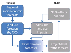
Land use forecasts are typically prepared by planning agencies to support long range transportation plans. They reflect anticipated future development, and are either based on, or closely coordinated with, regional socio-economic forecasts which consist of forecasts of population and employment.
Travel demand forecasts reflect anticipated regional traffic patterns for a typical day, based on the distribution of population and employment across the region. They are often used as inputs to traffic forecasts, which contain more detailed estimates of traffic characteristics, such as peak hour traffic volume, travel speeds, or turning movements at intersections. Traffic forecasts in turn form the basis for estimates of other effects such as air quality and noise.
The methods, data, and planning assumptions used to prepare forecasts should appropriately reflect the project’s characteristics and support the NEPA findings.
Several stages of land use, regional travel, and traffic forecasting typically occur during the NEPA process. Early in the process, land use and traffic forecasts can help:
- confirm the need to take action;
- determine the purpose for the project; and
- evaluate a range of reasonable alternatives to meet the purpose of the project.
The project’s initial traffic forecast often evolves over the course of a project study as the possible effects of the project are better understood. In particular, different project alternatives may have different land use effects. Different land use forecasts for some or all of the alternatives may be needed to capture those effects, and the differences in land use may in turn lead to different traffic forecasts. Differences in the forecasts can have an effect on the recommendations in the NEPA documents.
Because analysis of land use effects is complex and time-consuming, it is important to identify the project’s potential to influence future land use as early as possible. Ideally, this occurs during the scoping phase of the study so that suitable time and resources can be allocated for analysis at an appropriate level of detail. An effective screening strategy for land use effects will look at available data to determine whether:
- suitable development land or re-development opportunities are available in the study area;
- the project itself improves accessibility of developable land; and
- the land is, or will be, attractive to developers (providing “development pressure”).
The figure below illustrates how such screening can help determine whether alternative land use forecasts may be necessary to capture the distinct effects of project alternatives, or to document that no land use effects are expected.
“Induced travel” refers to observed increases in overall traffic volume that may occur when a new highway is opened or a previously congested highway is widened. “Induced growth” refers to new land development that occurs after a project is built.
A highway project will not always “induce” land use changes. For example, transportation investments in corridors with established development patterns may not induce a substantial level of new development, whereas a new highway that improves accessibility to undeveloped land may result in a stronger economic development response to access afforded by the project. Many factors may influence the suitability for land development, including land availability, access to municipal water/sewer, schools, or local zoning and taxation policies. These and other factors related to induced travel and induced growth are discussed in Section 2.4.6 of the Interim Guidance.
“Build” and “no-build” forecasts estimate land use or traffic effects that will occur if the project is built or not built. Each alternative is associated with conditions that describe what is expected to be built. The build forecasts report the expected land use and traffic effects for the build conditions associated with each alternative in the design year. Likewise, the no-build forecast reports expected land use and traffic effects if the project were not to be built. Despite the different conditions represented in each alternative, the resulting land use and traffic forecasts are often not substantially different. Consequently, a single build forecast may sometimes suffice, even for the build and no-build forecasts.
It is also important to analyze the land use and traffic effects adequately for each “build” alternative, compared to the “no-build” alternative (in which the project is not constructed). In situations where substantial land use changes are anticipated as a result of the project, the land use and traffic effects analysis for each alternative should be internally consistent, so that the land use forecast accounts for the distinctive features of the alternative, and the traffic forecast accounts for the anticipated land use for the alternative.
Analyzing the land use and traffic effects of the project may or may not yield separate land use and traffic forecasts for each alternative (“no-build” and one or more “build” alternatives). In all cases, however, the analysis should establish that the forecasts used to evaluate the effects of each alternative are reasonable, internally-consistent, and adequate. For example, if the same land use forecast is used to support analysis of traffic effects in several alternatives, the study should demonstrate that the land use effects of each alternative can be reasonably expected to be similar. This demonstration is especially important if the same forecasts will be used for no-build and build alternatives. It may be accomplished by referring to technical reports, white papers, or other documentation addressing factors that may influence growth in the study area.
If subsequent analysis during the study suggests that earlier traffic forecasts are no longer consistent with the updated land use, it is important to review, and if necessary revise, the traffic forecasts and the assessment of effects that depend on the traffic forecasts. The results of these reviews should be documented, even if they show that the forecasts or effects have not changed. If the forecasts or effects have changed, it is also important to review earlier decisions in the study, including Purpose and Need, screening of alternatives, and identification of the preferred alternative to ensure that these decisions are valid based on the most recent data.
Federal Statute2 and the joint FHWA/FTA planning regulations3 encourage a collaborative and integrated approach to transportation decision-making that considers benefits and impacts of proposed transportation system improvements to the environment, community, and economy during the transportation planning process. Planning and Environment Linkages (PEL) use the information, analysis, or products developed during transportation planning to inform the environmental review process, including NEPA. The FHWA has developed guidance4 on the Statutory and regulatory provisions for PEL. The FHWA has also developed examples of implementation of PEL and effective best practices5 on how to use planning products in environmental review.
It is important to review products of the planning process that are used to support NEPA determinations, even if those products were developed with NEPA in mind. Their use should be justified explicitly with respect to the characteristics of the project and the needs of the NEPA study. Such review is particularly important if the project may reasonably be anticipated to have substantial land use effects. The review should ensure that appropriate and internally consistent assumptions and forecasts have been used and documented throughout the NEPA process for each of the alternatives being analyzed (for example, by appropriately distinguishing effects of the build scenario relative to the no-build).
Back to Table of Contents
Scoping
What's the main concern?
Scoping is a collaborative process involving the lead agencies, resource and regulatory agencies, and the public. Scoping determines what factors and resources will be issues of concern during the NEPA process, and whether they may have an impact on the decision. It is not always possible to determine in advance if an issue will be of concern, so scoping may result in plans to assess the importance of an issue (such as land use effects) early in the study.
Inadequate consideration of land use forecasting and travel forecasting during the scoping process can create additional problems later in the NEPA process.
Scoping is an ideal time to start identifying potential land use forecast and traffic forecast connections to a NEPA project. The figure below identifies potential connections:
- Using land use forecasts to help develop the project’s traffic forecast;
- Using the project’s traffic forecast to help establish the need to take action;
- Using the project’s traffic forecast(s) to help evaluate a range of reasonable alternatives;
- Determining the potential for land use changes as an effect of the project; and
- Identifying methodologies for determining and assessing land use forecasts and traffic forecasts.
What's the risk to the project?
If the scoping process does not adequately consider land use forecasting and traffic forecasting issues, then:
- The project schedule may be delayed by many months if additional time must be budgeted to address unanticipated data analysis and forecasting needs;
- The project cost may increase due to the need for additional forecasts not originally budgeted;
- The documents may not meet NEPA requirements to disclose all the project impacts;
- Approvals from FHWA (e.g., prior concurrence, legal sufficiency, or a Record of Decision (ROD)) may be delayed or denied for lack of adequate documentation supporting conclusions or proposed courses of action; and
- The document may violate NEPA requirements due to false assumptions or a critical assumption that is undisclosed.
What do I need to ensure?
When you are involved in the scoping process, you can influence how land use forecasting and traffic forecasting will occur as part of the NEPA study. You can help the project sponsor prepare sound forecasts by asking the following types of questions:
- Could substantial land use effects result from the project?
- How will the project team determine whether land use effects are likely or not likely to arise?
- What data and methodologies will be used to support land use forecasting and the project’s traffic forecasting?
- How, and by whom, will the necessary project forecasts be prepared?
- Will existing forecasts prepared by outside agencies such as a Metropolitan Planning Organization (MPO) or State be used in the project study? How will the project team ensure that those forecasts are appropriate to support the NEPA process?
- Will the project study depend on land use or travel forecasts for assessing purpose and need, or for screening alternatives?
- Has the project budget and schedule allowed for the need to:
- Evaluate the potential for land use effects?
- Prepare appropriate and consistent land use, travel demand and traffic forecasts?
- Review and revisit those forecasts at later stages of the study?
- Review and revisit the decisions that may be affected by changes in those forecasts?
- Will alternative-specific traffic or land use forecasts need to be made, or will one set suffice (this question may need to be revisited later in the process)?
Reviewer Considerations
- Even if a project seems unlikely to have land use effects, it is important that the potential for such effects be explicitly evaluated early in the study, based on available data for existing and future conditions. If the project study finds that no land use effects are anticipated, that finding and the assumptions used to support it should be clearly documented. As a reviewer, it may be useful to presume that land use effects will occur, and challenge the project team to provide adequate evidence and analysis to convince you otherwise.
- Screening a project for possible land use effects should be documented in all cases where land use effects and associated traffic and travel might affect estimates of project impacts or proposed mitigation measures. Documentation of the screening should be provided even if the project is not anticipated to have land use effects.
- It is important that various members of the project team coordinate effectively with each other to ensure that land use forecasts and travel forecasts are developed and applied consistently. In particular, the project work plan should explain:
- How and when the results of Indirect and Cumulative Effects (ICE) analysis (where land use effects are frequently identified) will be accounted for in the project traffic forecasts;
- The effects analyses; and
- The decisions that those forecasts and analyses support (some of which are often prepared early in the study, and independently of the ICE analysis).
- The reviewer should verify the adequacy of land use and travel forecasting data and methods as early in the project study as possible. The later in the study such questions are raised, the more expensive they will be to address, the harder it will be to ensure that the final documents are complete and consistent, and the greater the danger that the project will not meet NEPA requirements, placing the project at risk.
- As early as possible, FHWA reviewers should notify FHWA offices that will later be involved in project review (including the Office of Chief Counsel and the Office of Planning, Environment, and Realty) that a project with potentially substantial land use effects is under development. Those offices are prepared to assist in reviewing the proposed land use and traffic analysis strategies and in providing technical support for subsequent reviews as the project proceeds.
Example
A project sponsor is developing a proposal to complete a 20-mile section of a regional beltway. The MPO’s regional travel demand model will be used to develop design year traffic forecasts with standardized project level adjustments to generate a project-level forecast. The freeway alignment considered in the MPO long range plan passes through several areas that are beginning to be developed, and the plan shows significant land use growth in those areas. The project plan does not include time or budget for developing land use forecasts because “the MPO has done all that.” The reviewer insists that the project team revise their work plan to allow time to study the MPO forecasts and to justify use of a single future land use forecast, or to develop separate build and no-build land use and travel forecasts, because the project may not receive a ROD unless land use issues have been adequately analyzed.
Where can I find more information on this topic?
Interim Guidance on the Application of Travel and Land Use Forecasting in NEPA, Sections 2.1 “Project Conditions and Forecasting Needs,” 2.2 “Suitability of Modeling Methods, Tools, and Underlying Data,” and 2.3 “Scoping and Collaboration on Methodologies.”
Back to Table of Contents
Traffic Forecast
What’s the main concern?
There are many techniques to develop a project’s traffic forecast. Some of these techniques rely on land use forecasts as inputs. The figure below represents how land use forecasts, along with other assumptions, are used as inputs to a traffic forecast.
If a project's traffic forecast relies on a land use forecast as an input, supporting documents should clearly explain how the land use forecast was developed and what assumptions were used. (For example, does the land use forecast presume a future in which the project is built?). Other assumptions used in preparing the traffic forecast that are not part of the land use forecast might, for example, include the proportion of future traffic expected to occur during peak hours or the value of time (minutes saved) for users of new toll facilities.
Even if the traffic forecast was prepared without a land use forecast (for example, if the future traffic is extrapolated from traffic count trends, as may be appropriate for a small project), it is possible that the study has not examined land use in sufficient detail. Consequently, if the project’s traffic forecast does not explicitly refer to a land use forecast, it is important that the study document the reasons that land use effects are presumed not to affect the traffic forecasts.
What’s the risk to the project?
If the NEPA documents do not explain how the land use forecast was developed, or fail to consider land use forecasts, the traffic forecast may rely on false assumptions. This can increase the risk of:
- An inaccurate traffic forecast;
- Violating NEPA requirements due to false assumptions or a critical assumption that is undisclosed.
What do I need to ensure?
As a reviewer, you should ensure that the traffic forecaster has a good understanding of how the land use information was initially developed and used to support the project’s traffic forecast. You should also ensure that the study includes appropriate documentation of the land use information. In general, the documentation should be sufficient to allow a technically proficient team to reproduce the study results from the source data. Below are some questions to consider (the list is not exhaustive or mandatory; consider asking other questions to assess the adequacy of the documents):
Control totals are estimates of future population and employment typically prepared by economists based on estimates of past and future trends over large geographic areas such as counties, metropolitan areas, or entire States. These are “controls” because local values of population and employment (e.g., in Traffic Analysis Zones or TAZs) are designed to add up to the regional control total – different local forecasts simply allocate the totals to different TAZs.
- Has the traffic forecast relied on the most recent land use forecast from relevant planning agencies?
- If the land use forecast allocated population and employment into Traffic Analysis Zones, were the allocations based on the project being built (or not)?
- Did the regional control totals for population and employment assume the project would be built (or not)?
To help document the project’s traffic forecast:
- What agencies or firms developed the forecast?
- How was the traffic forecast developed?
- What were the results, outputs, and conclusions?
- When was the work finalized and what period does it cover?
- When were the data used to support the forecast developed? Is it still reasonable to use?
- What tools and methodologies were utilized?
- What land use data (if any) served as inputs?
To help document the land use forecast (if applicable):
- What agencies or firms developed the forecast?
- How was the land use forecast developed?
- When were the data used to support the forecast developed? Are they still valid?
- When was the work finalized and what period does it cover? What tools and methodologies were utilized?
- What future transportation network was assumed as part of the land use forecast, and was the project present in that network?
- What other inputs and assumptions were used?
- Were regional control totals applied?
To help document regional control totals (if applicable):
- What agencies or firms developed the control totals?
- What tools and methodologies were used?
- When were the data used to support the forecast developed? Are they still valid?
- When was the work finalized and what period does it cover?
- What were the inputs and assumptions?
All of this information should either be:
- included in the environmental document or one of its appendices; or
- incorporated by reference to a technical report or other documents that are included in the project file.
If the information cannot be found, the project is at risk. You should reach out to the Resource Center or Headquarters to determine an effective course of action to remedy the problem.
Reviewer Considerations
- Very Important: If you are unsure sure whether a land use forecast best represents a “build” or “no-build” condition, identify the experts who had a role in preparing the forecasts and ask them “when you allocated the population and employment, did you assume the project would be built or not?” This information is critical to understanding whether the analysis includes appropriate forecasts for build and no-build conditions, and that the analysis of land use effects is complete and correct.
- It is not always necessary to prepare separate detailed “build” and “no-build” forecasts. Per recommendations in 23 CFR Part 450, Appendix A, it is reasonable for an MPO to use a single land use forecast to establish purpose and need and to perform preliminary screening of alternatives. Even if the analysis of indirect land use effects later shows that land use may change if the project were built, the analysis is adequate if it demonstrates that the project decisions are supported even when land use effects of the project are considered (for example by using sensitivity testing based on a quantitative analysis of indirect land use effects).
- A single MPO forecast may also serve as a reasonable basis for preparing forecasts for conditions (“build” or “no-build”) that were not considered when the MPO forecast was prepared. Standard techniques for adjusting an MPO forecast include (among others):
- Using a gravity model to reallocate development to or away from different parts of the area.
- Convening an informed Delphi panel to review data on available land, accessibility improvements due to the project, and other factors, including those that are not due to the project itself.
- Complete documentation of all forecasts, analyses, sensitivity tests, and conclusions is very important. Make sure you receive all the information, and that it explains how every number in the forecast was developed. Supporting documentation should be sufficiently detailed that a qualified analyst could reproduce the forecasts using the same methods, and given the same input data and key assumptions. For clarity, the primary NEPA documents should only show relevant analysis results, but an appendix or the project file should include all of the technical documents that explain how those results were calculated.
- As discussed below in the section on “Changes during NEPA” and “Reevaluation after the Decision”, any time new or updated information is received that might affect the traffic forecasts (such as new socioeconomic projections), there should be documentation of how the new information was evaluated, and of the implications for the decisions reported in the NEPA documents.
- Even if a project seems unlikely to have land use effects, the reviewer should explicitly evaluate potential for such effects early in the study, based on available data representing existing and future conditions. If the project study finds that no or minimal land use effects are anticipated, that finding should be supported with documentation of the assumptions and results of the evaluation. As a reviewer, it may be useful to presume that land use effects will occur, and challenge the project team to provide adequate evidence and analysis to convince you otherwise.
- A highway project will not always “induce” land use changes. If the project is not expected to have land use effects, the analysis supporting that determination should be clearly documented and supported by defensible assumptions. You should verify that the analysis and documentation of anticipated land use effects is complete (especially if the study asserts the project will have “no significant land use effects”), and that the traffic forecasts are consistent with the land use analysis.
- Many factors may influence the attractiveness for land development, including but not limited to land availability, access to municipal water/sewer, schools, or local zoning and taxation policies. Relevant factors should be considered using existing data and suitable assumptions about future conditions, and the findings regarding the possible land use influences should be supported in the project documentation. For example, transportation investments in corridors with established development patterns may not induce a substantial level of new development, whereas the extension of a highway that provides accessibility to undeveloped land may result in a stronger economic development response.
- A project’s traffic forecast may undergo changes during the NEPA study. Any of the steps in the NEPA study process may suggest the need for a new traffic forecast, or for revisions to an existing forecast, based on new information identified at that step. A traffic forecast may be prepared during the scoping process. Traffic forecasts may be revised, or new forecasts developed, to support analysis of alternatives. As the effects of each alternative are evaluated (especially indirect land use effects), the traffic forecasts may need further revision to ensure that each alternative (including the “no-build” alternative) consistently represents the anticipated effects.
Examples
Example #1:
A project sponsor uses a travel demand model to support the project’s traffic forecast. Travel demand models use land use as an input, reflected as estimates of population and employment. The project sponsor uses the land use information prepared by the local planning agency but does not bother to ask whether the planning agency expected the project to be built when they were preparing the land use forecast. Therefore, the project sponsor does not know whether the land use forecast is representative of the demand with or without the project. Without that information, the effects of the project will be more difficult to discern.
Example #2:
Assume the same conditions as Example #1, but this time the project sponsor asks whether the planning agency assumed the project would be built. The reply is “no, because the area is already growing rapidly and will continue whether the project is built or not.” Therefore, the reviewer has a higher confidence that the land use inputs used for the project’s build and no-build traffic forecasts are reasonable. The project documentation should explain the factors presently driving that growth, and show why the project is not expected to accelerate that growth.
Example #3:
Assume the same conditions as Example #2, but this time the planning agency’s reply is “no, because we weren’t sure whether the project would ever be built.” Therefore, the reviewer has a higher confidence that the land use inputs used for the project’s no-build traffic forecast are reasonable. The reviewer expects to see a consistent traffic forecast for the build condition that reflects the land use effects of the project.
Example #4:
Assume the same conditions as Example #2, but this time the planning agency’s reply is “yes, and so we added more jobs at the proposed interchanges.” Therefore, the reviewer has a higher confidence that the land use inputs used for the project’s separate build and no-build traffic forecasts are reasonable. The documentation should show how the estimate of additional jobs was developed relative to the no-build conditions, for example by using a gravity model to reallocate employment from elsewhere in the region.
Example #5:
A NEPA study used the MPO land use forecast as a build forecast, but also reported that the MPO forecast had been assembled with minimal adjustments from forecasts prepared independently by its individual jurisdictions. The document reported that a small number of jurisdictions had assumed that the project would not be built when they prepared their forecasts. The reviewer asked that the NEPA project team examine how the analysis would change if the MPO land use forecast were revised to consistently represent a build forecast. The study team provided an additional report showing that none of the jurisdictions that had assumed the project would not be built were near the project study area, and that land use effects in these jurisdictions from the project were likely to be negligible.
Where can I find more information on this topic?
Interim Guidance on the Application of Travel and Land Use Forecasting in NEPA, Section 2.1.5 “Incorporating Analyses Done in Transportation Planning Studies,” Section 2.4.2 “Objective Application of Forecasting Data and Methods,” and Section 2.4.6 “Addressing Land Development or Redistribution Effects.”
Back to Table of Contents
Purpose and Need
What's the main concern?
The planning process identifies deficiencies in the transportation system and strategies to address those deficiencies:
- Some of these strategies directly address desired land use changes, which may be presented as “economic development”;
- Some address desired changes to traffic flow or access, potentially influencing land use indirectly;
- Many have no bearing on land use changes (such as bridge replacement/rehabilitation, intersection improvement, or minor pavement widening).
If the project’s Purpose & Need intends to change future land use (such as an economic development purpose) or is based on a transportation-related purpose that suggests land use changes (such as accommodating the future demand on a highway), then inputs to the traffic forecast such as a land use forecast are critical to supporting the need for the project. Other criteria apart from land use and traffic may establish the need for the project, including public policies, access management, regional mobility, system connectivity, safety, etc. The figure below represents this relationship.
What’s the risk to the project?
If the forecasting results do not support the intended need of the project, the project may not be justifiable under NEPA.
What do I need to ensure?
As a reviewer of a project for which economic development or future traffic is part of the purpose and need, you should ensure that the land use, travel demand, and traffic forecasts adequately support the project need. You should also ensure appropriate documentation of the data and analysis supporting the project need, when that need depends on future land use or traffic changes.
Below are some questions to consider (the list is not exhaustive or mandatory; consider asking other questions to assess the adequacy of the documents):
- Does the Purpose & Need address economic development or anticipate changes to traffic flow or access based on forecasted land use changes?
- Is the land use forecast (including inputs and assumptions) consistent with the project’s traffic forecast inputs and assumptions?
- Does the documentation reasonably show how land use forecasts influenced the project’s traffic forecast and does the analysis use the forecasts to substantiate the need to take action?
To support the need for the project, ask:
- What is the basis for the suggested need (e.g., safety, roadway congestion, roadway condition)?
- Does the need for the project rely on future land use or traffic forecasts?
All of this information should either be:
- in the environmental document (including appendices); or
- incorporated by reference in other documents that are contained in the project file.
If the information cannot be found, the project may be at risk. You should reach out to the Resource Center or Headquarters to determine an effective course of action to remedy the problem.
Reviewer Considerations
- A highway project will not always “induce” land use changes. For example, transportation investments in corridors with established development patterns may not induce a substantial level of new development, whereas the extension of a highway that provides accessibility to undeveloped land may result in a stronger economic development response to access afforded by the project. Many factors may influence the attractiveness for land development, such as land availability, access to municipal water/sewer, schools, or local zoning and taxation policies.
- Economic development impacts are difficult to estimate and document. The most effective motivation for a transportation project appeals to specific transportation outcomes such as improved accessibility, safety improvements, or congestion relief. However, if the project’s documented purpose and need explicitly refers to economic development, it is important to ensure that the study provides suitable land use forecasts.
Examples
Example #1:
The Purpose & Need includes the phrase “to promote economic development.” The reviewer examines the project’s traffic forecast methodology, and discovers that the methodology used a travel demand model. This is the same travel demand model used by the regional planning process. Upon reviewing how the land use data were sub-allocated within the project study area, the reviewer discovers that your study area (which is currently undeveloped agricultural land) is projected to be undeveloped in the future. Thus, there is an apparent disconnect between the data and the project need (“is there really an economic development need when there are no anticipated land use changes?”). The project sponsor should develop an alternate land use forecast showing the development that the project is expected to facilitate.
Example #2:
The Purpose & Need includes “achieve a travel speed of 55mph in the design year.” Upon reviewing the project’s traffic forecast methodology, the reviewer discovers that the methodology used the same travel demand model used for the regional planning process. Upon reviewing how the land use data were sub-allocated within the project study area, the reviewer discovers that the study area is currently somewhat developed but the density and intensity of land use there is expected to increase significantly in the future, in spite of an inefficient existing transportation system. Therefore, the project’s purpose is to facilitate growth by improving the performance of the transportation system. Based on the land use information, the reviewer finds that the land use data reasonably support the need to improve the transportation system. The project may or may not need alternate land use forecasts, depending on the magnitude of growth, and whether the future growth is shown to be expected to occur with or without the project.
Where can I find more information on this topic?
Interim Guidance on the Application of Travel and Land Use Forecasting in NEPA, Sections 2.1.1 “Conceptual Review of Anticipated Analysis,” 2.4.1.2 “Indirect Effects,” and 2.4.6.2 “Addressing Land Development Effects in Alternatives Analysis.”
AASHTO “Practitioner's Handbook #7: Defining the Purpose and Need, and Determining the Range of Alternatives for Transportation Projects.”
Back to Table of Contents
Range of Alternatives
What's the main concern?
A strategy for eliminating alternatives from detailed consideration is to screen for whether an alternative meets the purpose of the project. Sometimes the forecasted traffic for individual alternatives determines whether an alternative meets the purpose of the project. The figure below depicts this decision:
- if the alternative cannot meet the purpose of the project, it should be eliminated from further consideration.
- if the alternative might meet the purpose of the project, it may be carried forward for detailed study.
If a traffic forecast is used to screen alternatives based on meeting (or not) the purpose of the project, then a traffic forecast relying on false or inappropriate land use assumptions may pose problems during the screening process.
What’s the risk to the project?
If alternative evaluations rely on inaccurate traffic or land use forecasts, the alternatives may be erroneously:
- eliminated from further consideration; or
- carried forward needlessly for further consideration.
What do I need to ensure?
As a reviewer, you should ensure that the criteria used to eliminate alternatives from further consideration were suitable. If the ability of the project to handle anticipated traffic is one of the criteria, then the land use forecasts supporting future traffic forecasts should be consistent with the alternative. That does not necessarily mean that alternative land use forecasts must be prepared for each alternative prior to screening. It does mean that if the assumptions made to develop the land use and traffic forecasts depend on land use that the alternative might facilitate, then it may be necessary to conduct more detailed analysis. You should also ensure appropriate documentation of the land use assumptions used to develop the project’s traffic forecast.
Below are some questions to consider (the list is not exhaustive or mandatory; consider asking other questions to assess the adequacy of the documents):
- Were the land use effects examined in sufficient detail to support eliminating the alternative?
- Do land use forecasts from the planning process that are used to support future traffic estimates include the project or not?
- Was the magnitude of the possible land use changes considered in the documentation explaining why an alternative was eliminated?
All of this information should either be:
- included in the environmental document (including appendices); or
- incorporated by reference to other documents that are included in the project file.
If the information cannot be found, the project is at risk. You should reach out to the Resource Center or Headquarters to determine an effective course of action to remedy the problem.
Reviewer Considerations
- If substantial land use changes are anticipated, you should verify that the conditions analyzed in the land use and traffic forecast for each alternative correspond to the proposed characteristics of the alternative. The most basic verification ensures that the land use used to develop the forecast is consistent with estimates of induced development (i.e., the growth that would not happen if the alternative were not built).
- The differences in the alternatives should correspond in intuitive ways with the forecasts and other estimates of effects (e.g., does anticipated new land development match up with access afforded by the alternative). If something seems confusing or incomplete, you should request additional documentation explaining the apparent anomaly. Even if the analysis was done correctly, the fact that the results or presentation seemed odd or insufficient may indicate that the documentation needs to be improved.
- If the study uses only one set of population and employment estimates at this stage of NEPA, but additional sets of population and employment are developed for alternatives later in the NEPA process (for example, during indirect and cumulative effects analysis), the documentation should show that decisions regarding which alternatives meet (or fail to meet) the purpose of the project have been reviewed in light of the new information. This can be accomplished by conducting and documenting a sensitivity analysis.
Examples
NOTE: Both examples below involve almost identical information. The only difference is the land use forecast assumption. After reading both examples, note how the screening can be different if unsure sure how the land use forecast was developed. That is why you should ensure that the project sponsor explains somewhere in the project records how the land use forecast was developed.
Example #1:
A project sponsor relied on a land use forecast from the planning process (as an input to a travel demand model). The land use forecast assumed implementing the project. Because of this assumption, additional population and employment were predicted within the project study area.
Sensitivity Analysis uses models or other tools to estimate how much of an input change would need to occur for the output to reach a certain threshold. Such analysis is useful when it is very costly to develop a set of new inputs (such as a complete land use forecast) or to conduct a full analysis. Sensitivity analysis can show that anticipated changes in forecast inputs will not have substantially different effects, so it is reasonable not to conduct a detailed analysis.
The traffic volume output from the travel demand model was evaluated and used as the project’s traffic forecast. The level of anticipated traffic indicated the Purpose seemed only to be satisfied by Alternative 1 (adding two general purpose travel lanes) but not Alternative 2 (an alternative involving a group of operational strategies). A sensitivity analysis was conducted to evaluate the magnitude of the land use changes due to Alternative 1, which showed that residual traffic growth without the project would cause Alternative 2 still to be inadequate. Thus, Alternative 2 was eliminated from further consideration.
Example #2:
A project sponsor relied on a land use forecast from the planning process (as an input to a travel demand model). The land use forecast assumed that the project would not be built. Because of this assumption, the analysis shows a continuation of existing development trends within the project study area. Additional analysis demonstrated that the project was not expected to induce additional growth.
The traffic volume output from the travel demand model was evaluated and used as the project’s traffic forecast. The level of anticipated traffic indicated the Purpose would be satisfied by Alternative 1 (adding two general purpose travel lanes) as well as by Alternative 2 (a group of operational strategies). Thus, neither alternative was eliminated based on this screening.
Neither screening process is necessarily right or wrong in these examples, but carefully considering the assumptions made in the land use and traffic forecasts, as well as the magnitude of potential land use effects, is necessary to support one conclusion over the other.
Where can I find more information on this topic?
Interim Guidance on the Application of Travel and Land Use Forecasting in NEPA, Section 2.4.3 “Refinement of the Analysis during Screening.”
Back to Table of Contents
Effects Analysis
What's the main concern?
NEPA requires consideration of the effects associated with implementing a project. Land use changes can be an effect, and they can also influence other effects, such as traffic, as well as effects that are caused by traffic, such as noise and air quality impacts. The figure below shows how land use changes between the “build” and “no-build” conditions are effects associated with the project.
Where the project is expected to facilitate substantial land use changes, the land use associated with not implementing the project (“no-build”) and the land use expected to change as a result of the project (“build”) must be identified. In this case, more than one set of land use assumptions and forecasts are appropriate, at a level of detail that addresses the specific characteristics of the project.
What’s the risk to the project?
It is often difficult to determine when reading a NEPA document whether a land use forecast from the planning process best represents the “build” or “no-build” condition, and this lack of clarity increases risk. Also, if the project may result in substantial land use effects, but the study does not develop distinct build and no-build forecasts (possibly including different land use forecasts for build alternatives that may have substantially different effects), then the effects analysis is incomplete. If the analysis erroneously assumes the wrong conditions or does not appropriately account for the effects the agency risks not fulfilling NEPA requirements and the project is at risk.
What do I need to ensure?
As a reviewer, you should ensure appropriate consideration of the land use forecasts (inputs to the effects analysis) and the land use effects (outputs from the effects analysis) when a project is expected to influence substantial land use changes, and ensure that the land use assumptions are consistent in the analysis of each alternative. The land use for each alternative should be considered. An affirmative statement about how the land use effects are expected to be the same (or different) among the alternatives should be included in the analysis.
There are three possible scenarios the reviewer should be aware of:
- One land use forecast is appropriate for both build and no-build conditions.
- One build land use forecast and one no-build land use forecast are appropriate.
- Two or more build land use forecasts for the build alternatives and one no-build land use forecast are appropriate.
Below are some questions to consider (the list is not exhaustive or mandatory; consider asking other questions to assess the adequacy of the documents):
- Are the land use forecasts based on suitable planning data and assumptions?
- Do land use forecasts from the local planning agency best represent the “build” or the “no-build” condition? Is the documentation of these forecasts adequate to understand all the assumptions used to create them? Are the assumptions consistent with those made elsewhere in the NEPA study?
- Have appropriate land use forecasts been prepared for each alternative that may reasonably be presumed to have substantial land use effects (including, at a minimum, separate forecasts for build and no-build conditions)?
- Have different forecasts been prepared for alternatives that are anticipated to have substantially different land use effects?
- If the build alternative is asserted not to have substantial land use effects compared to the no-build (so that a single land use forecast is used), has that assertion been fully considered at an appropriate level of detail? Have the conclusion and underlying evaluation and findings been adequately documented?
All of this information should either be:
- included in the environmental document (including appendices); or
- incorporated by reference to other documents that are included in the project file.
If the information cannot be found, the project is at risk. You should reach out to the Resource Center or Headquarters to determine an effective course of action to remedy the problem.
Reviewer Considerations
- Very Important: If you are not sure whether a land use forecast best represents a “build” or “no-build” condition, find out who actually allocated population and employment into the study area and ask them “when you allocated the population and employment, did you assume the project would be built or not”? This information is critical to understanding whether the analysis includes appropriate forecasts for build and no-build conditions, and that the analysis of land use effects is complete and correct. The NEPA document should be updated to clarify how this analysis was conducted.
- The development and analysis of “build” and “no-build” scenarios must adequately and consistently capture the characteristics of the two scenarios. If building the project may substantially influence land use, then an adequate effects analysis will likely require separate land use forecasts that show what development effects may reasonably be attributed to the project. The traffic effects due to the different land use forecasts should also be represented consistently, as changes in land use will lead to traffic effects and differences in other related effects such as noise or air quality.
- If the NEPA effects analysis concludes the project will not substantially change land use, the land use data would be the same for the “build” and the “no-build” conditions. Therefore, one land use forecast would be used for all alternatives. This finding of equivalent land use effects must be supported by analysis of available data and adequately documented (next bullet).
- If the NEPA study relies on a single land use forecast, it is critical to support that use by analysis of available data, and to document adequately why the project is presumed not to substantially influence future land use. There are many valid ways to reach a conclusion of no substantial influence. For example, regional accessibility might not be substantially improved if the project’s purpose is to eliminate a safety hazard, or reduce a bottleneck for existing traffic. Another case where no substantial influence is anticipated might occur if there is a lack of available developable and/or re-developable land in the study area.
- If the effects analysis concludes there will be substantial land use changes as a result of implementing the project, the project’s traffic forecast should be checked for consistency, and may need to be revisited and updated based on this new land use information. If there are changes to land use forecasts, these should be appropriately evaluated to estimate their potential influence on traffic forecasts and estimates of other effects to ensure that the study’s conclusions are consistently supported and still valid.
Examples
Example #1:
A single land use forecast was used in the development of traffic forecasts for the project, but the Indirect and Cumulative Effects documentation suggests that the build alternative may induce substantial development on available land. The documentation shows that the MPO prepared the land use forecast, and that the forecast included the project (and was thus a “build” forecast). The project is at risk because it has not adequately assessed and disclosed traffic conditions that may result if the project is not constructed. A no-build forecast of land use and traffic that removes land use changes facilitated by the project is needed.
Example #2:
The land use forecast from the planning process was assumed to represent a “no-build” analysis. Subsequent study concluded the project would substantially induce growth and land use assumptions were developed for a “build” analysis. However, information obtained later in the study showed that the planning process information already best represents the “build” condition. The project now has an increased risk of not complying with NEPA, because the study compared “build” versus “build” (instead of “build” versus “no-build”). A no-build forecast of land use and traffic that removes land use changes facilitated by the project is needed.
Example #3:
The land use forecast from the planning process was assumed to represent a “no-build” analysis. Rather than accepting the assumption about the content of the planning forecast, the project team confirmed the assumptions with the planning agency responsible for allocating population and employment within the study area. Later, the project team developed new “build” land use assumptions and concluded the project will substantially induce growth. Because the project team checked with the land use allocators from the planning process, the assertion that the planning process data represent a “no-build” condition was defensible.
Where can I find more information on this topic?
Interim Guidance on the Application of Travel and Land Use Forecasting in NEPA, Sections 2.4.2 “Objective Application of Forecasting Data and Methods,” 2.4.6 “Addressing Land Development or Redistribution Effects,” and 2.5.2 “Consistency.”
Back to Table of Contents
Preferred Alternative
What's the main concern?
The analysis of effects supports the identification of a preferred alternative. It is especially important that traffic forecasts used to analyze the effects of the preferred alternative consider all the distinctive and appropriate characteristics of that alternative, especially its land use effects. In particular, the no-build condition should be carefully evaluated to ensure that assumptions based on the preferred alternative are not inadvertently included.
Some transportation projects have been successfully challenged based on the assertion that the preferred alternative was selected in order to handle traffic that would not occur if the preferred alternative were not built. Ideally, this concern should have been addressed when developing the purpose and need. At this stage, it is important to verify that the preferred alternative has not influenced what are supposed to be no-build conditions. A correct analysis of the alternatives will take into account different land use and related traffic effects when identifying the preferred alternative.
The following figure illustrates that the preferred alternative should emerge from a complete analysis of alternative effects, rather than being pre-determined.
What’s the risk to the project?
Without well-developed “build” and “no-build” land use forecasts for transportation projects that are anticipated to have substantial land use effects, the conditions used to identify the preferred alternative may overstate future traffic in the “no-build” case, compared to the preferred alternative.
A particular risk occurs if land use and traffic effects due to the preferred alternative are implicitly included in the analysis of other alternatives (including the “no-build” alternative). That risk may arise if an MPO forecast that includes the preferred alternative is used for other alternatives without considering how land use might be different if another alternative were built.
What do I need to ensure?
You must ensure that the effects associated with the preferred alternative and each of the other alternatives are consistently and appropriately evaluated, including the potential for land use changes that are unique to each alternative (including the “no-build”).
- Below are some questions to consider (the list is not exhaustive or mandatory; consider asking other questions to assess the adequacy of the documents): For projects anticipated to have substantial land use effects, is the “build” alternative based on a “build” land use assumption?
- For projects anticipated to have substantial land use effects, is the “no-build” alternative based on a “no-build” land use assumption?
- Is there adequate documentation?
This evaluation is particularly important later in the study, when additional information (such as might emerge from Indirect and Cumulative Effects analysis) may suggest that land use effects will be greater (or significantly different) from what was original evaluated. Questions to ask at each review point include:
- Has new information been developed or become available that suggests that the project land use estimates should be revised?
- Have those estimates been revised, and have all assumptions and decisions that depend on them been re-evaluated to ensure that they still apply, including identification of the preferred alternative?
All of this information should either be:
- included in the environmental document (including appendices); or
- incorporated by reference to other documents that are included in the project file.
If the information cannot be found, the project is at risk. You should reach out to the Resource Center or Headquarters to determine an effective course of action to remedy the problem.
Examples
Example #1:
A project proposed for a new alignment was evaluated for land use effects, and appropriate build and no-build land use forecasts were constructed based on developable land near the corridor. Later, during the evaluation of indirect effects, the land use estimates for growth due to the project were revised downward due to significant resource constraints on a large tract of land that had originally been identified as available for development. The traffic effects used to support identification of the preferred alternative were not revised. The project was then at risk on the grounds that with the new lower development forecast, an alternative that had previously been eliminated might now be viable, and the analysis supporting the preferred alternative should have been reviewed.
Reviewer Considerations
- Ensure early on that the project schedule allows time to prepare alternate forecasts and to reconsider decisions made based on initial land use and traffic analysis.
- Verify that changes to forecasts made later are carried back into earlier portions of the analysis, and that the analysis and conclusions of the study remain consistent throughout. In particular, verify that results of indirect and cumulative effect analysis are consistent with the analysis and decisions presented elsewhere in the documents.
Where can I find more information on this topic?
Interim Guidance on the Application of Travel and Land Use Forecasting in NEPA, Sections 2.4.2 “Objective Application of Forecasting Data and Methods,” 2.5.1 “Potential for Reevaluating Analysis.”
Back to Table of Contents
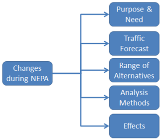
Changes during NEPA
What's the main concern?
The NEPA process takes time. Many parts of a NEPA analysis occur at different times. The reviewer should be aware of how new forecast information can affect previous decisions and to make sure the analysis is internally consistent. The figure below represents sections of an environmental document which may need to be revisited due to new information.
The question of analysis methods is potentially important: it may be appropriate to use simplified traffic forecasting tools such as trend analysis to prepare project traffic estimates in cases where most demand is generated outside the study area and the project itself is not anticipated to substantially affect local land use. If it is later found that the project might substantially influence land use, it may not be enough to adjust the traffic forecasts numerically: a new analysis approach that involves land use and travel demand forecasting may be necessary. Careful analysis of the project’s potential for land use effects early in the study will minimize such risks and ensure that adequate analysis methods are applied.
What’s the risk to the project?
Because these components of an environmental document are completed at different times and sometimes by different teams, there is a risk that they will contain incomplete or contradictory information. For example, one part of the NEPA document might conclude there will be no substantial land use effects whereas another part concludes there will be substantial land use effects. If there is internal inconsistency, then the NEPA analysis may create public confusion about the project and put the project at increased risk.
What do I need to ensure?
You should understand the timing of various components (analyses, technical reports, coordination or consultation efforts, and decisions) during the NEPA process. As additional information is generated (such as an indirect and cumulative effects technical report or new land use forecasts from the local planning group) you should look for ways the new information might influence previous analysis (such as a traffic forecast) and decisions (such as which alternatives meet the purpose of the project).
If you have new land use forecasting information you should consider the following questions:
- Is the information adequately documented?
- How might the new land use information affect the project’s traffic forecasting (if at all)?
- Did the traffic forecasters consider whether the traffic forecast needs to be updated?
- Did the forecasters document the reason for changing (or not changing) their forecast?
If you have new traffic forecasting information you should consider the following questions:
- Is the information adequately documented?
- How might it affect the project’s need?
- How might if affect the identification of reasonable alternatives and the identification of the preferred alternative?
- How might it influence any analysis methods?
- How might it change any effects analysis?
- Is there adequate documentation of these reconsiderations?
If you have other new information, consider:
- Does it relate to a land use forecast or traffic forecast for the project?
- Is there adequate documentation of how other elements of the study were reconsidered in light of the new information?
All of this information should either be:
- included in the environmental document (including appendices); or
- incorporated by reference to other documents that are included in the project file.
If the information cannot be found, the project is at risk. You should reach out to the Resource Center or Headquarters to determine an effective course of action to remedy the problem.
Reviewer Considerations
- A highway project will not always “induce” substantial land use changes. For example, transportation investments in corridors with established development patterns may not induce a substantial level of new development, whereas the extension of a highway that provides accessibility to undeveloped land may result in a stronger economic development response to access afforded by the project. Many factors may influence the attractiveness for land development, including land availability, access to municipal water/sewer, schools, or local zoning and taxation policies.
- If the effects analysis concludes there will be substantial land use changes as a result of implementing the project, the project’s traffic forecast should be checked for consistency, and may need to be revisited and updated based on this new land use information. If there are changes to land use forecasts, these should be appropriately evaluated to estimate their potential influence on traffic forecasts and estimates of other effects to ensure that the study’s conclusions are consistently supported and still valid.
- Just because new information becomes available, it does not mean the analysis and decision-making must change. However, each of the earlier analyses and conclusions should be evaluated to ensure that they remain consistent and valid.
Examples
Example #1 (potentially affecting the traffic forecast and the effects analysis):
The indirect effects analysis was completed a year after the project’s traffic forecast. The analysis suggested the project will substantially change the land development patterns. The updated land development patterns were not consistent with the land use forecast used to develop the project traffic forecast, so the traffic forecast was revised for the build alternatives. However, the effects of the revised traffic were not updated, and the project was at risk because the analysis of potential noise effects on nearby residential neighborhoods was not consistent with the new traffic estimate.
Example #2 (potentially affecting the traffic forecast):
The project’s traffic forecast relied on the MPO’s estimated Year 2035 population and employment data. Before the NEPA process was completed, the MPO updated its land use forecast to 2040, while recognizing an overall slowing of the growth rate. Because of a new forecast of population and employment, the project team revisited the build and no-build alternatives and concluded that travel demand along the project corridor would be considerably less. The alternatives were reevaluated based on the new information and a different preferred alternative (a less expensive arterial upgrade rather than a freeway) was identified, and a new set of traffic forecasts and effects analysis was prepared. Because the project team was in regular communication with the MPO, the downward revision to the future land use forecast was not a surprise, and the project team was well prepared to revise its earlier analyses.
Example #3 (potentially affecting the effects analysis):
During the effects analysis, the indirect effects analysis concluded, “a minimal chance of land use changing as a result of the project.” During the public involvement process, a stakeholder provided a third-party study concluding, “if you build the road, development will follow.” Because of this conflicting piece of information, the reviewer helped the project team ensure that the new information was incorporated in the project documents. The reviewer ensured that the new information was available to the land use and travel forecasters, that assumptions leading to the different indirect effects conclusions were systematically compared, that the indirect effects analysis was updated to account for the different assumptions and to justify the assumptions that were used, and that any changes in the indirect effects analysis were carried through consistently to the rest of the project’s effects analyses.
Example #4 (potentially affecting the traffic forecast):
The project’s traffic forecast relied on the MPO land use forecast. The MPO land use forecast relied on population control totals from the State demography agency. Since the project’s traffic forecast was developed, the State demographer revised the MPO population forecast downward. Because of the new input (population estimate from the State) to the MPO land use forecast, which is an input to the project’s traffic forecast, the reviewer helped to ensure the project’s traffic forecaster was aware of this new information. The traffic forecaster then considered how this new information would affect the project’s traffic forecast, the project’s traffic forecast was updated accordingly, and all of the project analyses and conclusions that depended on the traffic forecast were checked for consistency with the new information.
Example #5 (potentially affecting the traffic forecast and the Purpose & Need):
The project’s traffic forecast relied on the MPO land use forecast. The Purpose & Need relied on the project’s traffic forecast. The MPO land use forecast relied on population control totals from the State demography agency. Since the project’s traffic forecast was developed, the State demographer revised the MPO population forecast downward. Because of the new input (population estimate from the State) to the MPO land use forecast, which is an input to the project’s traffic forecast, new forecasts were prepared and because there was a significant traffic decrease in the project corridor, the reviewer ensured that the project need was still supported by the revised traffic forecast.
Where can I find more information on this topic?
Interim Guidance on the Application of Travel and Land Use Forecasting in NEPA, Sections 2.5.1 “Potential for Reevaluating Analysis,” and 2.5.2 “Consistency.”
Back to Table of Contents
Reevaluation After the Decision
What's the main concern?
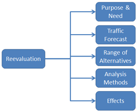
Although a NEPA decision (Record of Decision (ROD) or a Finding of No Significant Impact (FONSI)) may have occurred, FHWA regulations (23 CFR 771.129) require a reevaluation of the NEPA decision prior to the next FHWA major approval (23 CFR 771.129(c)). If the possibility of significant changes to the effects analysis is indicated due to substantively revised forecast inputs, such as new MPO land use forecasts or revised population and employment control totals, the EIS (or EA) should be comprehensively reviewed. If the estimates of effects will change significantly due to the altered forecasts, it may be necessary to prepare an EIS (if an EA was originally prepared) or a Supplemental EIS based on the new information.
The figure below depicts where new information might affect elements of NEPA during reevaluation:
What’s the risk to the project?
New information or changes in the project after the NEPA approval may indicate information in the original NEPA documents should be revisited. The decision may require reevaluation before it can serve as the basis for an FHWA action, such as a funding authorization. The consequences are similar to new information that may occur while the study is still underway, including the risk that the project will be challenged in court.
What do I need to ensure?
When you become aware of new information (for example, if the local planning agency has updated its land use forecast) after the signing of the FONSI or ROD, look for:
- ways the new information might influence previous analysis (such as a traffic forecast); and
- decisions (such as which alternatives meet the purpose of the project) that may be affected by the information. Ensure that the analysis and decisions are still supported.
If you have new land use forecasting information, you should consider the following questions:
- Is the information adequately documented?
- How might it affect the project’s traffic forecasting (if at all)?
- Did the traffic forecasters consider whether the traffic forecast needs to be updated (or not)?
- Did the forecasters document the reason for changing (or not) their forecast?
- Is there adequate documentation that the original NEPA decision is still valid (or not)?
If you have new traffic forecasting information, you should consider the following questions:
- Is the information adequately documented?
- How might it affect the project’s need?
- How might if affect the identification of a range of reasonable alternatives?
- How might it influence any analysis methods?
- How might it change any effects analysis?
- Is there adequate documentation of any of these reconsiderations?
- Is there adequate documentation that the original NEPA decision is still valid (or not)?
If you have other new information, you should consider the following questions:
- Does the information relate to a land use forecast or traffic forecast for the project?
- Is there adequate documentation of the reconsideration?
- Is there adequate documentation that the original NEPA decision is still valid (or not)?
Consider whether an EA or EIS must be supplemented, pursuant to 23 CFR 771.130:
- Does the new land use forecast result in a new, significant impact that was not evaluated in the EIS? (If so, you’ll need to supplement the EA or EIS.)
- Does the new traffic forecast result in a new, significant impact that was not evaluated in the EIS? (If so, you’ll need to supplement the EA or EIS.)
If the project is a CE and / or EA, consider the following questions:
- Does the new land use forecast result in a significant impact? (If so, an EIS will be needed.)
- Does the new traffic forecast result in a significant impact? (If so, an EIS will be needed.)
All of this information should either be:
- included in the environmental document (including appendices); or
- incorporated by reference to other documents that are included in the project file.
If the information cannot be found, the project is at risk. You should reach out to the Resource Center or Headquarters to determine an effective course of action to remedy the problem.
Reviewer Considerations
- It may be useful to encourage the project team to conduct sensitivity analyses with their analysis models prior to deciding whether the NEPA decision remains valid. A sensitivity analysis will systematically alter key inputs in the forecasting models to get a sense of how big a resulting change will occur in traffic and other project effects. If the revised forecasts show changes that are small enough not to alter the findings in the original NEPA decision, it may be possible to continue to rely on the original study. However, the sensitivity analysis and the conclusions drawn from it must be fully documented (including all assumptions and thresholds used to support those conclusions).
Examples
Example #1 (potentially affecting the traffic forecast):
An EIS was prepared for the project. The project’s traffic forecast relied on the MPO’s estimated Year 2035 population and employment data. After NEPA is completed, the MPO updates its land use forecast to 2040, while recognizing an overall increasing of the growth rate. Because of the new forecast of population and employment, the project team revisited the build and no-build alternatives and concluded that travel demand along the project corridor would be considerably greater than originally estimated. The new conditions were carefully evaluated in order to determine whether the project was still supported and that the analysis of effects remained adequate. The effects analysis concluded there were new, significant impacts, and a Supplemental EIS was prepared to account for them.
Example #2 (potentially affecting the traffic forecast):
An EIS was prepared for the project. The project’s traffic forecast relied on the MPO land use forecast. The MPO land use forecast relied on population control totals from the State demography agency. Since the project’s traffic forecast, the State demographer revised the MPO population forecast downward. Because of this new input (population estimate from the State) to the MPO land use forecast, which is an input to the project’s traffic forecast, the conclusions in the Final EIS were reevaluated based on the new information. Though some of the analyses were updated, careful review showed that the conclusions of the study were still supported, no new significant impacts were identified, and a Supplemental EIS was not required.
Example #3 (potentially affecting the traffic forecast and the Purpose & Need):
An EA was prepared for the project. The project’s traffic forecast relied on the MPO land use forecast. The Purpose & Need relied on the project’s traffic forecast. The MPO land use forecast relied on population control totals from the State demography agency. Since the FONSI was issued, the State demographer revised the MPO population forecast downward. Because of this new input (population estimate from the State) to the MPO land use forecast, which is an input to the project’s traffic forecast, the FONSI decision was reevaluated to ensure that it remained valid. The analysis concluded there were still not significant impacts. Therefore, the FONSI remained valid.
Example #4 (potentially affecting the traffic forecast, Purpose & Need, and Range of Alternatives):
An EIS was prepared for the project. The project’s traffic forecast relied on the MPO land use forecast. The Purpose & Need relied on the project’s traffic forecast. The MPO land use forecast relied on population control totals from the State demography agency. Since the project’s traffic forecast, the State demographer revised the MPO population forecast downward. The project analyses in the EIS were reviewed, and in this case, the changes were significant and required a Supplemental EIS. The SEIS updated the project’s Purpose & Need, and developed and analyzed a set of new, arterial-based alternatives that replaced the originally proposed freeway alternatives.
Where can I find more information on this topic?
Interim Guidance on the Application of Travel and Land Use Forecasting in NEPA, Sections 2.5.1 “Potential for Reevaluating Analysis,” and 2.5.2 “Consistency.”
_____________________________
1 This practice is consistent with Congress’s longstanding intent that “federally-funded highway and transit projects must flow from metropolitan and statewide transportation planning processes (pursuant to 23 U.S.C. 134-135 and 49 U.S.C. 5303-5306).” 23 CFR Pt. 450, Appendix A.

