
Using GIS Tools to Improve Project Delivery
State Departments of Transportation (DOTs) and other transportation agencies are increasingly exploring and utilizing tools that link technology with planning. As spatial data becomes more widely available, practitioners are capitalizing on the intersections between Geographic Information Systems (GIS) and required environmental review processes, to accelerate and improve the quality of environmental impact evaluations.
GIS is a collection of software, hardware, and data used to store, manipulate, analyze, and present geographically referenced information. The ability to consider a range of environmental impacts holistically is a valuable tool for expediting project delivery. GIS tools provide access to data that allows practitioners to consider important variables early in the planning process, ensuring that transportation decisions and discussions are driven by data. The Federal Highway Administration’s (FHWA) Geospatial Data Collaboration effort supports these practices and encourages the sharing of geospatial tools and technologies.
Data-Driven Decisionmaking Expedites Planning and Review Processes
Once GIS capabilities are in place, they significantly reduce the time agencies spend collecting, assembling, and managing data. To develop and utilize GIS tools, planners must first standardize geospatial data collection, integrate or consolidate the data into a common framework, and develop standards and common formats. Many agencies choose to build custom tools (e.g., screening tools, data libraries, or multi-agency decision support systems), but they may also emulate existing platforms, such as the Utah Department of Transportation’s (UDOT) UPlan.
UDOT’s UPlan Combines Data Sources for Improved Environmental Planning
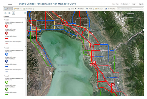
UPlan’s powerful analytical capabilities allow users to simultaneously measure a variety of environmental impacts. (Courtesy of UDOT)
UPlan is an interactive planning and analysis web application that contains a wide range of datasets, including environmental, natural resource, and planning data. Data in UPlan is compiled from a variety of sources and displayed spatially on an interactive map. Reports, websites, and public comments can be spatially linked, so all data associated with a project or study is visible in one place.
Local businesses, UDOT partners, and the public may also access the data used to create the dynamic maps and analytical tools found in UPlan. Users can download and access data within other applications, through UPlan’s robust data repository—UGate. Both UPlan and UGate are accessible via mobile device, making the tools even more practical and user-friendly.
UDOT utilizes UPlan to streamline its environmental decisionmaking through the Utah Planning and Environment Linkage (uPEL) Application, an approach developed by FHWA and modified for Utah. uPEL is a geographic planning tool that uses natural resource and demographic data to assess the impacts that a proposed transportation project may have on environmental and community resources. Potential impacts are assigned to one of three tiers and ranked in terms of resource sensitivity, indicating issues that would lengthen project and regulation time or require potential mitigation or extensive public engagement. Using a tiered system helps to determine which projects are most likely to lead to conflicts with stakeholders, time, and costs.
GIS Tools Improve Project Efficiency
Data management saves time.
Previously disconnected data sources are consolidated and collected into standardized frameworks, removing the need to travel or hire contractors for data collection.
Functionality simplifies processes.
Practitioners can view real-time data in an accessible, actionable format, allowing for faster analysis and documentation.
Collaboration strengthens outcomes.
Plans and projects can be synchronized among State agencies, local governments, Federal agencies, utility companies, and other stakeholders who may have additional data critical to the transportation planning process.
Transparency increases support.
Businesses, local government, and the public can access and share dynamic, responsive data and participate in the planning process.
GIS-Based Streamlining Spreads to Other States
Many States have adopted UPlan’s framework, adding their own data and customizing it to meet their specific needs. The American Association of State Highway and Transportation Officials (AASHTO) has also endorsed UPlan, championing its technology and encouraging State DOTs to adopt the UPlan framework through its AASHTO Innovation Initiative (AII).
The AII launched the Geospatial Online Transportation User Group, which provides ongoing support and development of comprehensive web-based GIS for transportation agencies. AASHTO also hosts an annual GIS conference where streamlining the National Environmental Policy Act review processes is a frequent topic.
Many States are now utilizing GIS to streamline environmental reviews and accelerate project delivery. Below are several examples of custom GIS initiatives and tactics that State DOTs have implemented:
Florida Department of Transportation (FDOT): FDOT works with the University of Florida to provide and use data in the University’s Florida Geographic Data Library, which includes important environmental and cultural information such as wetlands locations, archaeological sites, and endangered species habitat data.
Pennsylvania Department of Transportation (PennDOT): The Pennsylvania Historical and Museum Commission partnered with PennDOT to make archaeological and historic resource data from several decades more accessible. Through the creation of the Cultural Resources Geographic Information System, a map-based inventory of the historic and archaeological sites and surveys, users can instantly view records and data that previously required travel to the physical archives in Harrisburg, Pennsylvania.
Washington Department of Transportation (WSDOT): WSDOT’s Environmental GIS Workbench is a custom GIS application with over 700 layers of various types of environmental and natural resource data. Using Workbench, WSDOT staff can locate transportation projects and display environmental data for that location. This helps planners to flag potential environmental issues that will affect project planning.
Better Interagency Relationships, an Ancillary Benefit of Using GIS Tools
GIS tools enable more effective projects by facilitating highly efficient planning and documentation, and saving time and money through reliable, pre-established datasets and analyses. As web-based tools continue to grow in popularity, agency collaboration will also likely increase, reducing industry silos and encouraging shared data pools. This move towards open data also promotes open government, inviting the public to understand and view the data behind decisionmaking processes. The relationships built through these projects—both interagency and with the public—can ultimately lead to project benefits across departments, agencies, and States.
Contact Information
Mark Sarmiento
Office of Planning, Environment, and Realty
Federal Highway Administration
Mark.Sarmiento@dot.gov
(202) 366-4828
Becky Hjelm
GIS Manager
Utah Department of Transportation
BHjelm@utah.gov
(801) 386-4162
Successes in Stewardship is a Federal Highway Administration newsletter highlighting current environmental streamlining and stewardship practices from around the country. Click here to subscribe, or call (617) 494-3719 for more information.

