PEL
and Corridor Planning
State of the Practice Review of Planning and Environment Linkages Implementation in Corridor Planning
July 2014
← Back to PEL and Corridor Planning Report
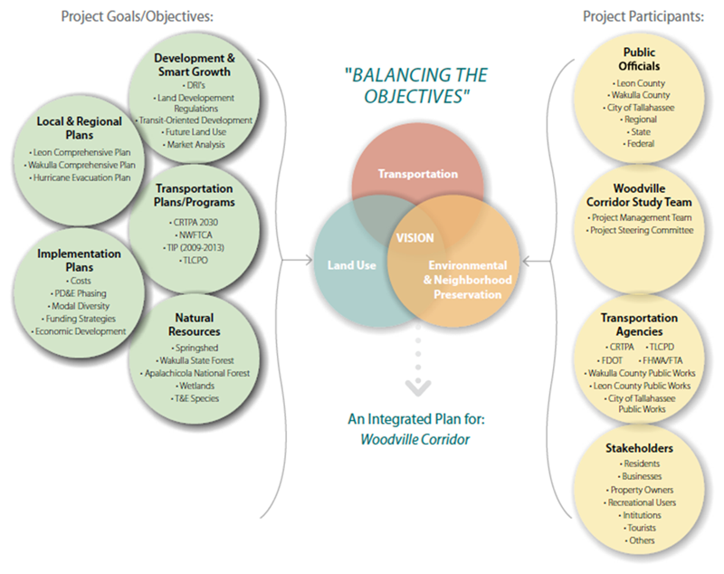
Figure 1: Balancing the Objectives, An Integrated Approach (Source: Woodville Highway South Corridor Study)
Extended image description
Graphic image from Florida’s Woodville Highway South Corridor Study titled “Balancing the Objectives: An Integrated Plan for Woodville Corridor.” The image is divided into three vertical sections: inputs on the left (Project Goals/Objectives) and the right (Project Participants) contribute to the Balanced Objectives in the middle.
The Project Goals/Objectives are:
- Development & Smart Growth
-
DRIs
- Land Development Regulations
- Transit-Oriented Development
- Future Land Use
- Market Analysis
- Local & Regional Plans
- Leon Comprehensive Plan
- Wakulla Comprehensive Plan
- Hurricane Evacuation Plan
- Transportation Plans/Programs
-
CRTPA
2030
-
NWFTCA
-
TIP
(2009-2013)
-
TLCPO
- Implementation Plans
- Costs
-
PD&E
Phasing
- Modal Diversity
- Funding Strategies
- Economic Development
- Natural Resources
- Springshed
- Wakulla State Forest
- Apalachicola National Forest
- Wetlands
-
T&E
Species
The Project Participants are:
- Public Officials
- Leon County
- Wakulla County
- City of Tallahassee
- Regional
- State
- Federal
- Woodville Corridor Study Team
- Project Management Team
- Project Steering Committee
- Transportation Agencies
- CRTPA
-
TLCPD
-
FDOT
-
FHWA/FTA
- Wakulla County Public Works
- Leon County Public Works
- City of Tallahassee Public Works
- Stakeholders
- Residents
- Businesses
- Property Owners
- Recreational Users
- Institutions
- Tourists
- Others
The three objectives (Transportation, Land Use, and Environmental & Neighborhood Preservation) are represented by three overlapping circles, whose intersection is labeled “Vison.”
← Back to PEL and Corridor Planning Report

