SHRP2 C19 Expediting Project Delivery
Case Studies Series
Expediting Project Delivery (C19) is a product developed under the Second Strategic Highway Research Program (SHRP2) to help transportation agencies deliver projects with greater efficiency and speed by encouraging the use of innovative approaches and early coordination with resource agencies, stakeholders, and the public. The product identifies 16 common constraints to efficient project delivery and recommends 24 strategies, organized into six themes, to expedite project delivery.
Expediting Project Delivery
The Expediting Project Delivery Strategies are organized into the following six themes. The main themes covered in this case study are in bold.
- Improve public involvement and support.
- Improve resource agency involvement and collaboration.
- Demonstrate real commitment to the project.
- Improve internal communication and coordination.
- Streamline decision making.
- Integrate across all phases of project delivery.
This product saves time by reducing project delays while also providing innovative approaches to improve transportation planning and decision making. This product allows agencies to anticipate where delays are expected to occur and to apply tested strategies to avoid or reduce delays during all phases of project development and delivery.
Maricopa Association of Governments (MAG)
This case study illustrates how the Maricopa Association of Governments (MAG), the regional planning agency for Maricopa County based in Phoenix, Arizona, applied two Expediting Project Delivery strategies to improve its transportation planning process.
Summary
Budget: MAG used $240,000 in SHRP2 Implementation Assistance Program (IAP) Lead Adopter funding from FHWA to work with members of the Western Regional Alliance (WRA) and other partner agencies (collectively referred to as partner agencies), to address strategies under the SHRP2 C19 Product, Expediting Project Delivery.
Process: MAG, along with partner agencies and other stakeholders, undertook three activities to help expedite transportation project delivery: 1) identifying transportation- and geographic information system (GIS)-related data through outreach in the Intermountain West (IMW) region; 2) developing the IMW Story Map, an interactive data tool for transportation planners; and 3) developing a model risk register, which analyzes risk levels associated with delivering a transportation project, to assess risks in the Interstate 11 (I-11) corridor.
Product: MAG created the IMW Story Map and a model risk register for the I-11 Corridor. This work helped to expand MAG’s existing cooperative efforts on an IMW transportation vision with various agencies throughout the IMW region.
Time Frame: MAG began the effort in April 2014 and concluded the effort in October 2016.
Challenges: MAG faced challenges to implementing C19 that included: data availability and differences in agency data classifications, and geographic diversity of partner agencies. Benefits of implementing C19 included increased understanding of data resources in the region, increased communication and improved relationships among partner agencies, and a transferable data collection process. MAG’s next steps are to continue to foster the dialogue among partner agencies and stakeholders and pursue economic analysis in transportation planning.
The IMW Region
The nine States in the IMW region are in the top 18 by land mass and comprise 934,916 square miles or 26% of the total land mass of the United States. The region contains:
- 30 million people, or 9.5% of the U.S. population.
- 545,000 miles or 13.3% of the nation’s public roads.
- >18,500 miles of freight railroad. >46,000 bridges, 37 border ports of entry, and 91 major airports.
- 48 MPOs.
- 46.4% of the region’s land is Federally-managed
Background
The IMW region contains large urban cities (e.g., Phoenix, Arizona and Denver, Colorado), surrounded by vast amounts of Federal, Tribal, and rural land. Due to recent population growth around these cities, the IMW region’s transportation infrastructure needs additional capacity improvements to accommodate the movement of people and goods. This requires coordination with agencies and stakeholders across political and State lines.
MAG applied for C19 funding to connect with WRA members and other partner agencies to discuss the issues facing the region, focus on long-term strategies for multimodal transportation and develop the IMW transportation vision. This connection will allow agencies to keep up with the growth in the region and to enhance economic opportunities. The WRA is an organization comprised of metropolitan planning organizations (MPOs) and transit organizations in five western cities that seeks to connect the region to 21st century global network. Fundamental goals of MAG’s project included building new relationships and strengthening existing ones, and creating awareness to expedite planning and environmental review of key transportation projects within the IMW region.
Product Implementation
MAG used the C19 IAP funding to:
- Identify IMW transportation- and GIS-related data resources through outreach to key stakeholders;
- Develop the IMW Story Map, an interactive data tool for transportation planners; and
- Develop a model risk register that planners can adapt for their particular transportation projects. The risk register analyzes risk levels associated with delivering a transportation project and expedites planning and environmental review.
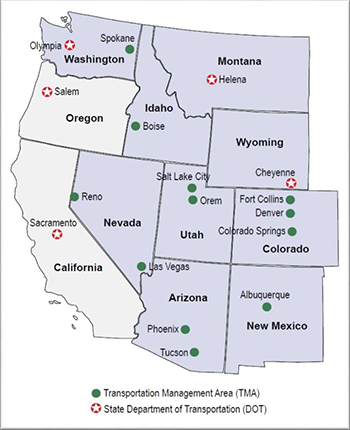
 Figure 1: IMW Region - a map of the IMW region, which is
shaded in purple. Source: MAG C19 Report
MAG began the effort in April 2014 when it contacted directors of MPOs, transportation management agencies (TMAs), and other stakeholder entities throughout the IMW to introduce the project. Shortly after, MAG held a kick-off teleconference among the directors to further discuss the project.
Identification of IMW Data Resources Through Outreach to Stakeholders
Beginning in August 2014, MAG focused on developing two GIS surveys for partner agencies to:
- Assess available GIS data resources and data sharing practices from partner agencies;
- Develop a common GIS vision/platform;
- Collaborate on data conflicts, data standards, and gaps; and
- Develop best methods for sharing data.
MAG received responses from 15 agencies, including 11 MPOs and 4 State DOTs.
On October 31, 2014, MAG and 16 of its stakeholders began webinar presentations on their GIS resources, which continued throughout the life of the project. The presentations helped to highlight relevant available resources and provide information to assist with the development of a data-sharing platform.
From January to March 2015, MAG conducted follow-up interviews to confirm data from survey responses. MAG then consolidated, analyzed, and assessed the responses and interviews, providing an understanding of the data resources by agency and for the IMW region as a whole. This extensive amount of data mining was useful for this project and can serve as a baseline for any further, relevant efforts.
Through MAG’s work identifying data resources and convening practitioners, stakeholders in the IWM region developed a network of GIS and technical professionals to exchange ideas on data issues impacting their respective agencies, highlight the tools each agency developed, and form recommendations for future data sharing efforts.
 Figure 2: C19 Project Timeline
Development of the IMW Story Map
After conducting the two GIS surveys and completing various interviews with stakeholders, MAG developed draft land use lookup tables for the IMW. These lookup tables were a significant step toward understanding the available data resources and aligning expectations of what could be accomplished with existing data shared by partner agencies.
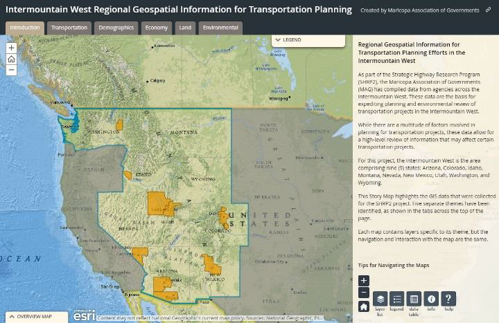
 Figure 3: IMW Story Map – a screenshot of the IMW Story Map viewer. Source: Intermountain West Regional Geospatial
Information for Transportation Planning Website
On August 27-28, 2015, 26 technical staff from 14 agencies convened at a key meeting in Denver, Colorado, to provide input and share information on the C19 project. At the meeting, MAG staff gave presentations on project data, growth patterns, and common data and mapping. MAG and the attendees storyboarded a proposed data viewer and provided input on aspects of it.
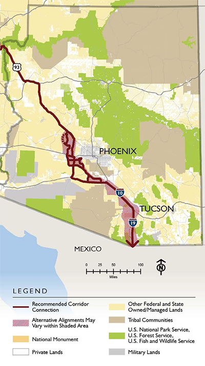
 Figure 4: I-11 and IWCS Recommended Corridor Alternatives.
Source: MAG C19 Report
Participants recommended that there be continued discussions and collaboration to determine next steps for this project’s data-sharing platform.
Based on feedback from the meeting attendees, MAG and the technical team realized creating a data platform was not feasible at the time due to the different data resources of the various stakeholders, their varying levels of interest in interconnectability, and the enormous scope of the project. MAG subsequently decided to create an IMW Story Map, which compiles data from its team partners, Federal agencies, other local and regional agencies across the IMW, and proprietary databases. The IMW Story Map interface provides a simple online viewer to display spatial data with a brief synopsis or analysis of the data and includes 26 data layers from 11 authoritative mapping services. These data allow for a high-level review of information that may affect certain transportation projects. Five separate themes were identified for inclusion in the IMW Story Map including Transportation, Demographics, Economy, Land, and Environmental.
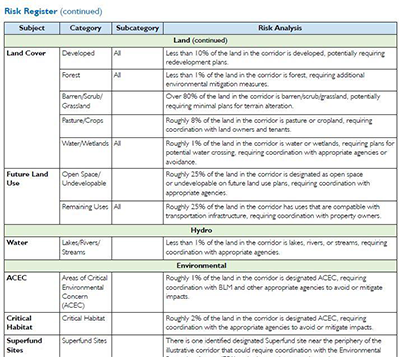
 Figure 5: Model Risk Register – a screenshot of part of the Model Risk
Register. Source: MAG C19 Report
MAG found significant benefits from the C19 project’s data coordination, such as agencies’ improved ability to visualize projects geospatially and identify their broader impacts. Ultimately, the IMW Story Map can be used as the basis of a larger data platform should the partner agencies pursue it.
Model Risk Register
The C19 funding also helped MAG develop a risk register for the I-11 corridor. The risk register bridged the gap between design and construction by identifying unseen risks and developing a framework for mitigation. MAG conducted informative interviews with the California DOT (Caltrans) and Colorado DOT (CDOT) on developing a risk register to provide additional background. All participating agencies were asked if they used risk registers and at the time, and Caltrans and CDOT had the most applicable experience to share with MAG. In further discussions with partner agencies, MAG discovered that most did not specifically use a risk register, but they do analyze and incorporate risk management in planning efforts. As such, the technical team decided the risk register would serve as a model for the broader IMW region that partner agencies could adapt to their specific projects.
Between the start of the project and the development of the risk register, the I-11 Tier 1 Environmental Impact Statement (EIS) process began on a portion of the I-11 and Intermountain West Corridor Study (IWCS) preferred corridor alignment between Nogales and Wickenburg, Arizona. In order to ensure that the C19 work did not impact the I-11 Tier 1 EIS study process in any way, MAG developed the risk register as a high-level tool providing an overview and qualitative measures of the risks.
Highlights from the I-11 risk register include:
- 25% of land in the corridor is owned by the Bureau of Land Management, and will need increased coordination on right-of-way acquisition. May have restrictions on potential access points and connections.
- Over 90% of land in the corridor slopes at 15% or less. While desirable from an engineering design perspective, it creates potential drainage and associated challenges.
- Over 80% of the land in the corridor is barren/scrub/grassland, potentially requiring minimal plans for terrain alteration.
- Roughly 3% of land in corridor is designated national park, making it highly unlikely ROW will be acquired. May have restrictions on location of freeway and access points.
The risk register categorizes risks and encourages practitioners to consider risks to a project from multiple angles. MAG hopes that the risk register will serve as a model for other agencies to identify and manage risk in project development going forward.
The development of the risk register, identification of data resources through outreach to stakeholders, and creation of the IMW Story MAP allowed MAG and partner agencies to see that by uniting, they can solve common problems, take an active role in addressing concerns of various stakeholders on regional issues that cross political jurisdictions, and shape the IMW transportation vision going forward.
Challenges to Implementation
While MAG faced some implementation challenges, these challenges were relatively minimal and easy for the agency to overcome.
- Challenge: Differences in agency data classifications and availability. While identifying data resources in the IMW area, MAG realized that each jurisdiction defines land use categories differently to satisfy its particular needs. Given the size of the IMW region, agencies used a great variety of categories. MAG recognized that the data classifications would need to be standardized to create a cohesive dataset for land use across the IMW region.
- Solution: Creation of land use codes and lookup table. MAG worked with the partner agencies to create a standardized set of land use codes for use in the IMW Story Map. MAG also created a lookup table for each agency to match existing and future land use categories using the agreed-upon land use codes in the IMW Story Map. This activity required considerable resources from each agency but was necessary to make the IMW Story Map a useful tool for transportation planners.
- Challenge: Geographic diversity and sheer number of agencies involved. The IWM region is large, and the various agencies were not concentrated in one area, but instead throughout a very large geographic region. The 20 plus agencies involved had various staffing levels and resources that could be dedicated to the project. This made it difficult for consistent participation and engagement from all agencies. It would have been ideal for all TMAs and State DOTs in the IMW region to participate in the project.
- Solution: Regular webinars and teleconferences. To allow for effective communication and sustained engagement, MAG relied on webinars and regular teleconferences to exchange information and ideas instead of in-person meetings. Throughout the life of the project, MAG hosted over 13 webinars that included multiple presentations from different stakeholders. In addition to the webinars, numerous teleconferences with various stakeholders occurred throughout the project. These teleconferences helped fill in knowledge gaps and allowed for the sharing of experiences and lessons learned, as well as provided input on the direction of the C19 project to the technical team. MAG also created a project website so that resources could be easily accessed and housed in a central location.
MAG was able to succeed in its C19 project by effectively communicating with the IMW region agencies and through stakeholder engagement.
Benefits
Several benefits have come out of MAG’s Expediting Project Delivery work, including the following.
- Increased understanding of data resources in the region. MAG’s outreach provided a thorough assessment of data resources in the IMW. The work helped define GIS data resources already available, identify existing resource gaps, and determine potential methods of filling those gaps in an efficient manner for the partner agencies. The data will improve agencies’ ability to visualize projects geospatially and identify their broader impacts going forward.
- Increased communication and improved relationships among partner agencies. MAG’s extensive outreach in the IMW region was unprecedented and drastically increased communication among agencies in the region. Agencies appreciated the opportunity to exchange information during the C19 project and expressed interest in continuing to communicate after its conclusion. The project also emphasized the importance of bringing the right agencies together early on and building or continuing to foster relationships. MAG noted that the engagement and involvement of partner agencies have been responsible for the project’s success in meeting its goals and priming the region for future collaboration. Having such involved partner agencies also assisted in the transfer of best practices and lessons learned to help agencies with their day-to-day work.
- Transferrable data collection process. MAG found the data collection process for the C19 project so successful, that it is now employing similar techniques for data collection on a business inventory with other MPO Directors in Arizona. MAG anticipates leveraging the C19 work in this new effort.
- Significant IMW detailed information developed. MAG found having IMW information such as general description of the region, existing IMW transportation resources and economic impacts of transportation infrastructure projects to be beneficial.
These benefits will have a lasting effect on improving MAG and partner agencies’ planning processes and increasing coordination among stakeholders in the IMW region.
Next Steps
Based on the experiences from its C19 project, MAG plans to apply lessons learned and engage in additional outreach with a smaller number of agencies, which will be more manageable and less resource-intensive. Using the geospatial data collected through the C19 effort, MAG will frame the delivery of goods and services through the transportation network in future planning efforts. MAG also aims to incorporate economic analysis into transportation planning, prioritization, and decision making going forward.
For the IMW corridor as a whole, MAG recognizes that it is important for partner agencies agencies and IMW region stakeholders to meet regularly to continue the dialogue on transportation needs and major projects in the region. MAG plans to work with the IMW stakeholder staff to continue to refine the IMW transportation vision and better understand short- and long-term, regionally significant transportation projects. MAG will coordinate a follow-up meeting with IMW policy directors to present the refined IMW transportation vision for further review and consideration.
Additionally, MAG hopes to work with its IMW partners to more fully align their resources to better share data, including existing and projected needs for transportation projects going forward. This data sharing will allow for continued benefits in the region, including improved economic development directly related to transportation improvements. If additional funding becomes available, MAG recommends developing and receiving feedback on a proof of concept tool to serve as a common GIS platform. Additional goals for the future include conducting a transportation corridor profile study to document current and future planning efforts; and, considering formalizing the relationship among the stakeholder agencies into a partnership similar to the I-95 Corridor Coalition.
For more information, contact:
Denise McClafferty
Regional Program Manager
Maricopa Association of Governments
DMcClafferty@azmag.gov
https://azmag.gov/Programs/Economic-Development/SHRP2-Expediting-Project-Delivery-Grant
David Williams
Environmental Protection Specialist
Federal Highway Administration
David.Williams@dot.gov
https://www.environment.fhwa.dot.gov/Env_initiatives/SHRP2.aspx

