Implementing Ecosystem Crediting
September 2014
Notice
This document is disseminated under the sponsorship of the U.S. Department of Transportation in the interest of information exchange. The U.S. Government assumes no liability for the use of the information contained in this document.
The U.S. Government does not endorse products or manufacturers. Trademarks or manufacturers’ names appear in this report only because they are considered essential to the objective of the document.
Quality Assurance Statement
The Federal Highway Administration (FHWA) provides high-quality information to serve Government, industry, and the public in a manner that promotes public understanding. Standards and policies are used to ensure and maximize the quality, objectivity, utility, and integrity of its information. FHWA periodically reviews quality issues and adjusts its programs and processes to ensure continuous quality improvement.
| 1. Report No. |
2. Government Accession No. |
3. Recipient’s Catalog No. |
4. Title and Subtitle
Implementing Ecosystem Crediting |
5. Report Date
September 2014 |
| 6. Performing Organization Code |
7. Author(s)
ICF International, Oregon State University, NatureServe, & Venner Consulting |
8. Performing Organization Report No. |
9. Performing Organization Name and Address
ICF International, Oregon State University, NatureServe, & Venner Consulting |
10. Work Unit No. (TRAIS) |
| 11. Contract or Grant No. |
12. Sponsoring Agency Name and Address
Federal Highway Administration
Office of Safety Research and Development
6300 Georgetown Pike
McLean, VA 22101*
|
13. Type of Report and Period Covered
Final Report |
| 14. Sponsoring Agency Code |
| 15. Supplementary Notes |
16. Abstract
Step 6 of the Integrated Ecological Framework (IEF) directs transportation agencies to “develop a consistent strategy and metrics to measure ecological impacts, restoration benefits, and long-term performance.” This report introduces the results of a study designed to both examine the obstacles preventing transportation agencies and metropolitan planning organizations (MPOs) from creating meaningful crediting strategies, and to describe methods and opportunities to develop these strategies. Key products of the study include four documents included as appendices. The first is a report on the status of ongoing crediting-related programs at 10 state Departments of Transportation (DOTs) and 10 MPOs, with provides recommendations for expanding their crediting. The second is the Framework 1 report, the Transportation Ecosystem Services Crediting Guide. This guide is designed to be a practical stepwise manual that assumes no prior experience with ecosystem crediting and describes the phases of developing a strategy: feasibility, convening, design, testing, agreement, operations, and adaptive management. The third is the Framework 2 report, Crediting and Valuation for DOTs with Complex Conditions, which reports on the challenges, innovations, and opportunities related to crediting and valuation in transportation in California. The last is a review of the literature and survey of practices, indicating that most compensatory mitigation is accounted for on an acreage basis without regard to the types, quantities, and qualities of ecosystem services provided.
|
17. Key Words
crediting, ecosystems, valuation in transportation |
18. Distribution Statement
No restrictions. This document is available to the public through the National Technical Information Service Alexandria, Virginia 22312 |
19. Security Classif.(of this report)
Unclassified |
20. Security Classif.(of this page)
Unclassified |
21. No. of Pages |
22. Price |
Reproduction of completed page authorized
Form DOT F 1700.7 (8-72)
Table of Contents
Introduction
This report is the final submitted deliverable for the Federal Highway Administration (FHWA) task order, “SHRP 2 C06B Step 6: Crediting System Implementation.” The goal of this project was to develop a strategy to help Department of Transportation (DOT) and metropolitan planning organization (MPO) staff through the process of creating or expanding Ecosystem Crediting Systems. The intention is for these crediting system implementation resources to contribute to better mitigation and restoration outcomes, and thus, better social, economic, and environmental outcomes across the U.S.
Objectives of this Report
The primary products of this effort are three separate documents providing guidance to DOTs and MPOs, each designed to stand on their own. This report provides an overarching background and description of the approach taken to develop these products, as well as a brief introduction to each of the three reports. This report provides descriptions of the framework development process, the project background, methods used, and information on how to use the frameworks. The report also describes the purpose of the different products and documents, how to access the different materials available, and expertise needed to develop a crediting program. Together, these materials are designed to provide the requested guidance related to ecosystem crediting strategies relevant to the transportation community.
Background
In 2008, Congress directed the U.S. Department of Agriculture (USDA) to facilitate the development of environmental markets and ensure the participation of America’s farmers, ranchers, and forest landowners. In 2011, the President’s Council of Advisors for Science and Technology wrote a report entitled, “Sustaining Environmental Capital: Protecting Society and the Economy.” The report stresses the importance to both society and the nation of properly valuing the nation’s air, water, forests, grasslands, and biodiversity, as well as the need to remove what they call, “perverse governmental incentives” currently in place.
The ability to measure and value environmental benefits (clean water, air, food, fiber, climate regulation) may help assure these services are maintained over time. Considering both the cost and benefits of ecosystem service values is one way to consider the value of both impacts and improvements to the environment in the same decision-space. As such, it can represent a new way for transportation agencies and regulatory agencies to address unavoidable losses and associated mitigation. Ecosystem credits also have the ability to improve the environmental benefits associated with mitigation and restoration while reducing the time and cost of project delivery.
Ecosystem Service Crediting in the Transportation Process
Ecosystem services measurement and crediting tools can help DOTs measure environmental impacts from transportation projects and benefits from mitigation investments, reducing transaction costs, improving environmental outcomes, and shortening the time needed to implement projects. An ecosystem crediting strategy is a regional or statewide system that supports the development and use of ecosystem credits by DOTs and MPOs. These include crediting systems that look at conservation and restoration priorities within an ecosystem-scale context agreed to under a multi-agency and stakeholder process addressing multiple resources (an Eco-Logical approach).
The valuation of environmental attributes and corresponding credits may be used at several points during the transportation planning process: in the regional planning process, in the system planning process, in corridor planning, in programming and in project development. These are detailed in Appendix C. At regional scales, valuation and crediting may consist of:
- establishing the linkages between impacts and corresponding ecological outcomes;
- establishing the credit-value system that allows for comparing among dissimilar ecological values and estimating total costs of credits; and
- establishing agreements about rules used to guide the use of valuation and credits in eventual project delivery.
At the corridor scale, valuation and crediting can tier from the regional system and consist of:
- comparing values among projects proposed along a single corridor;
- comparing values among corridors in a regional network;
- seeking agreement on corridor-specific value or credit tradeoffs among involved parties; and
- programming long-term actions along and among corridors based on credit-values and corresponding costs.
Incorporating the values of the environmental impacts early within transportation planning and analysis can better account for the benefits and costs that society may incur. By doing so, project programming decisions can be based partly on maximizing environmental benefits and accounting for environmental values that are lost and gained among various alternatives, an important advance in sustainable transportation planning. The project development stage requires comparing project alternatives in environmental analysis and permitting, benefits and values estimation, and cost estimates to:
- describe exactly the value change associated with each project alternative;
- describe the corresponding credit loss and gain from impacts and mitigation actions; and
- gain agreement among all parties involved that a particular action, bank, or mitigation package results in the greatest net value.
↑ Return to Table of Contents
Using Ecosystem Services to Generate Credits
Ecosystem service credits are essentially units of environmental benefit that draw equivalencies among non-like values. Credits are often proposed in planning and mitigating infrastructure development as a way to get ecologically-meaningful mitigation accomplished. An example of a credit is a hectare of habitat, or dollar equivalents of that habitat. Credits arise from valuing natural attributes (e.g., habitat types), patterns (e.g., distribution of habitat elements), and processes (e.g., nutrient cycling), and can be defined as the exchange currency for benefits and disbenefits when developing, mitigating (avoid, minimize, compensate), or restoring habitat.
Credits are a way to make valuation more concrete and visible in transportation planning, programming, construction, mitigation, and monitoring. In theory, credits are created through the conservation or high-quality restoration of naturally functioning ecosystems. They represent the quantification of things ranging from provision of clean water for community drinking supplies, to pollination of agricultural crops, to sequestering carbon to help mitigate climate change.
Using a crediting approach to mitigation requires methods and protocols to quantify units of environmental benefit (credits) or impact (debits), as well as a crediting framework in which regulatory agencies and stakeholders agree to a common set of standards and operating procedures that govern how credits and debits can be used to meet mitigation requirements. This allows planners to align mitigation objectives and more efficiently identify mitigation and restoration opportunities that address multiple ecosystem services. Accurately measured project impacts and mitigation site benefits can be more readily converted into credits.
Characterizing a watershed or ecosystem’s functions can be a first step to estimating ecosystem credits, and new tools are becoming available to do this (see New Federal Resources to Conduct Ecosystem Services Analysis). Quantifying impacts to functions as credits means that people can start talking in a similar language and understand benefits, disbenefits, and trade-offs. In siting and designing compensatory mitigation projects, it is necessary to assure the site will improve the overall condition of a larger hydrologic or ecologic unit or system and provide at least the important functions to be credited. To be functional, an accounting or credit system provides a way to both indicate relative or absolute effects or impact and to measure potential performance of credits, usually in the context of mitigation. When estimating the value of functions, such as for wetlands, the first step is to understand what characteristics of the resource, such as a wetland, can be valued, based on the functions, uses, and values, which in turn stem from different ecological processes (e.g., photosynthesis), characteristics (e.g., water depth), and structure (e.g., fauna and flora). Wetlands provide both services (e.g., flood control) and goods (e.g., edible fish) that have economic value. Monetary valuation methodology can create problems when addressing ecosystem attributes such as biodiversity, which can be very difficult to price and requires non-market valuation techniques.
Historically, many natural resource crediting systems have accounted for area impacted, as a way of counting the resource that does not require monetization or fiscal valuation of ecosystem services. An expert in this field, van Oosterzee (2014), suggested that using rule-based approaches at regional scales eases implementation of an ecosystem services approach, allowing a wider range of individual land-owners to opt-in because they can avoid part of the transaction cost (credit development). Regions and districts can develop plans at the region, corridor, and project level that tier from overall frameworks and ecoregional priorities.
↑ Return to Table of Contents
Benefits of an Ecosystem Services Crediting Approach
Crediting systems represent a formal, transparent, and systematic way to measure or estimate the equivalent costs and benefits of actions that affect a system. Ecosystem credits have known and predictable value, known and predictable appreciation or depreciation rates, and can be exchanged through financial or other transactions. They vary from simple trading systems, as outlined in the new Army Corps of Engineers rule for wetland function mitigation, to more complex systems addressing multiple ecosystem service types. Ecosystem services crediting can enable transportation agencies to take advantage of national, regional, and local biological information to identify more ecologically effective and efficient solutions for the DOT and environmental interests involved, whether in programmatic fashion or for particular projects.
When ecosystem services are identified and valued, they may be considered and accounted for in agency decision making. Accounting for such impacts and benefits helps the public see how they have been considered, a public benefit in its own right.
An ecosystem service crediting approach offers a different lens through which to view natural resources than traditional single-resource regulatory frameworks and can result in meaningful and beneficial changes in the way agencies measure and manage natural resources and engage and serve the public. Among the benefits are strengthened relationships with stakeholders and other partners, more comprehensive and transparent accounting of management impacts (both positive and negative), and increased opportunity for innovative and cost-effective management alternatives and improved ecological, economic, and social outcomes.
An ecosystem services crediting strategy can help agencies to work across resources and program areas. Such integration provides a more holistic picture of a management area, diminishes the potential that impacts (especially off-site or non-target impacts) “fall through the cracks,” and offers an opportunity to explicitly weigh trade-offs across resources.
The TRB research project SHRP C06A described many of the benefits individual agencies and environmental professionals and planners see from implementing ecosystem and watershed approaches. Likewise, ecosystem services measurement and crediting tools can assist the transportation planning and implementation process by improving the process of mitigating environmental impacts through:
- Reducing transaction costs
- Improving environmental outcomes
- Potentially shortening the time needed to implement projects
- Saving time and resources of transportation and natural resource staff
- Reducing uncertainty associated with a project and its environmental analysis
- Providing critical information for development of environmental performance measures
- Identifying ways to leverage existing mitigation resources and achieve resource agencies’ restoration/conservation goals or plans
- Transferring liability to a trained and responsible party for providing and maintaining the service
An ecosystem service approach to planning encourages managers to ask questions and evaluate impacts on a broader scale than occurs with traditional approaches. Consideration of interrelated goods and services, rather than a single or narrower list of individual resources, provides opportunities for more comprehensive priority setting, targeting of cost-effective approaches, and leveraging new sources of funding. Investments may be consolidated in conservation or mitigation banks or strategic conservation or restoration plans supported by in-lieu fees.
↑ Return to Table of Contents
Obstacles to Using an Ecosystem Services Crediting Approach
Understanding the steps involved in developing a crediting strategy has been particularly difficult for Departments of Transportation (DOTs) and metropolitan planning organizations (MPOs). To address this, the ICF team has attempted to develop frameworks tailored for various different circumstances and scenarios encountered by DOTs and many of the MPOs across the country. These were designed to address the varied barriers to implementing alternative mitigation, crediting, and programmatic agreements among DOTs and MPOs. This will enable the crediting approach to be more accessible and feasible for DOTs and MPOs, based on their concerns and expertise.
Ecosystem services crediting has often been difficult to initiate. Operationalizing an ecosystem services framework requires information about:
- Current landscape conditions and how they are changing
- Forecasts of how management activities will alter the time trajectory of landscape change in a context of likely natural disturbances and climate change
- What people value about the landscape, how much they value those things, and how their values might be changing
In addition to the benefits from ecosystem approaches, SHRP2 C06A investigated the barriers that planners and environmental professionals were encountering to implementation at their agencies. The project at hand took a closer look at issues, obstacles, and challenges particular to ecosystem service crediting in particular, and these are documented in Appendix A. A few trends were apparent after reviewing the literature. Multi-stakeholder processes to identify conservation priorities are increasingly frequent, and many regions have created something like a Regional Ecological Framework, although they may call it something else. While programmatic agreements are being used more often, the literature on these efforts typically includes no discussion of a credit system, much less a market, and no statement of how credits are defined and measured. It appears most compensatory mitigation is simply accounted for on an aerial basis (e.g., acres) without regard to the types, quantities, and qualities of ecosystem services provided. The literature review illustrated the challenges transportation agencies face in trying to negotiate the complexities of facilitating the creation of crediting systems and of using existing crediting systems to offset transportation project impacts (Anderson 2005, Colorado State University 2013, Kett 2001, Venner 2002, Womble & Doyle 2012). The literature review also demonstrated the lack of incentives facing landowners who are interested in producing and selling credits in many places (Hartwell et al. 2010, Kett 2011, LaRocco & Deal 2011, Scarlett & Boyd 2011).
In the state of the practice survey conducted for this project, most respondents thought it was “very important” to expand the development and use of ecosystem crediting strategies in their state or region and thought the most important missing piece was “methods and tools for calculating the value of ecosystem credits and debits.” Federal efforts are addressing this core challenge as well as the issues of single-resource versus more collaborative, multi-benefit (Eco-Logical or ecosystem-based) approaches. This report documents discusses the approaches, tools, methods, and guidance transportation agencies can use now to implement ecosystem services crediting.
An ecosystem crediting strategy is a more consistent, programmatic approach to measuring, tracking, approving, and acquiring multiple types of ecosystem credits to meet the needs for transportation projects. A crediting strategy can give transportation agencies the predictability they need to plan and implement projects, regulatory agencies and the public more certainty that conservation goals are being met, and everyone a more consistent way to track and account for debits and credits.
↑ Return to Table of Contents
Methodology & Introduction to Key Products
To support the development of frameworks for ecosystem service crediting, this FHWA project conducted a literature review, a review of the state of the practice in DOTs and MPOs across the country, and a content analysis of the major ecosystem crediting documents, focusing on those generated by federal agencies as well as those that describe steps, methods, or tools for implementing crediting programs. A spreadsheet with these resources is available upon request. In the state-of-the-practice survey, a majority of respondents said there were efforts underway to implement and/or use ecosystem crediting statewide or on a watershed scale, guided by landscape-scale, ecosystem-based conservation and restoration priorities.
For this project, three major documents were produced. The first is a description of the state of the practice in MPOs and DOTs across the country with some experience with crediting for wetlands, endangered species, or 303d issues, but lacking an integrated statewide program. Statewide or regional programs in Colorado, Florida, Maryland, Minnesota, Montana, Ohio, Oregon, and Washington were described, along with potential steps identified to help these states move to a more complete, multi-crediting system. The document was an effort to help these states move towards a multiservice crediting program, using the collaboration and planning developed in Steps 1-5 of the Integrated Ecological Framework (IEF) to create a viable crediting program. And it was hoped to help teach other states exploring crediting what had been done in different parts of the country.
The second document was Framework 1, created to provide a stepwise foundation for many state DOTs and MPOs across the country with limited experience in crediting and no ongoing extensive programs in the crediting and alternative mitigation area. This was created to be a guide with discrete and defined actions for agencies interested in crediting, and is called the “Transportation Ecosystem Services Crediting Guide.” The guide contains information on the steps agencies need to be following, things to be considered, and expertise needed.
Finally, Framework 2 addresses states with exceptionally complex issues and a large number of ongoing programs, especially those with local, regional, or statewide statutes that included crediting programs. The framework focuses on transportation crediting in California, which has the most complex array of regional programs, laws, and transportation conflicts.
Lastly, a number of outreach materials have been developed to help MPOs and DOTs better understand how to implement ecosystem services crediting strategies in the transportation arena. These include presentations describing the major products developed, and resources to direct agencies to important information needed to make progress.
↑ Return to Table of Contents
Transportation Ecosystem Crediting in Active States
As mentioned previously, the documents and outputs of the frameworks were designed to address the varied barriers to implementing alternative mitigation, crediting and programmatic agreements among DOTs and MPOs, to enable the crediting approach to be more accessible and feasible. “Creating Transportation Focused Ecosystem Crediting Frameworks in States with Active Ongoing Crediting or Mitigation Trading Programs or State Watershed Restoration Programs,” was designed to assist states and MPOs with ongoing crediting related programs and some involvement in the ecosystem services crediting arena, by recommending additional steps that could expand their programs. It was also designed to allow states considering crediting to evaluate programs from different states, to evaluate what is working in different places, and why.
At the outset of the project, the team believed that it might be possible to integrate efforts underway in successful programs, particularly the Maryland Watershed Resources Registry and the North Carolina Ecosystem Enhancement Program (EEP), to provide a model for DOTs in many states. However, it quickly became obvious that the structure of different state governments and the accessibility and partnerships between state governments and the regulatory agencies are too variable to allow a single method to work for all of these states. As a result, this report has developed background information and recommendations tailored for each of the states individually.
The North Carolina EEP has been successful because the state has a Department of Environment and Natural Resources (DENR) that was willing to take on the management and administration of a crediting program for NCDOT. The Maryland Watershed Resources Registry has succeeded because a group of regulators at EPA and the Army Corps of Engineers decided to create a tool for restoration and mitigation prioritization and analysis. The creators of the Watershed Registry are interested in attempting to implement watershed registries elsewhere in the U.S., with work underway in Pennsylvania. But to date it has only been successfully implemented in Maryland.
Therefore, the IEF team has chosen to provide descriptions of the ongoing crediting and crediting-related programs in each of the states and the selected MPOs with ongoing crediting programs, along with potential recommendations as to how a transportation-focused crediting strategy might be most simply or efficiently developed in each state or MPO. The assumption is that the individual recommendations will be able to take into account the primary services or impacts that the program may need to address in their crediting strategy, as well as the nature of their state government, and existing programs and laws in the state. The individual descriptions and recommendations provided are based on the assessment of the current state of the practice, and may be somewhat limited by restrictions of the requirements in the paperwork reduction act. However, updates to these draft recommendations based on reviews and additional information or from program and law changes are easily accommodated and anticipated as these states and MPOs review the document.
↑ Return to Table of Contents
Framework 1. The Transportation Ecosystem Crediting Strategy Guide
The guide is based on many years of experience, mostly from the northwest, to create and implement multiple service ecosystem services crediting programs, by the Willamette Partnership. The Willamette Partnership is a 501(c)3 nonprofit organization focused on developing markets based on detailed accounting procedures for multiple types of ecosystem service credits. It has worked to create science-based ecosystem service quantification methods in partnership with regulatory agencies and with agencies needing ecosystem credits. The process, called “Counting on the Environment,” is a multi-stakeholder agreement that uses a shared accounting system for quantifying impacts and benefits to ecosystems in a market-based and/or mitigation banking system.
For this project, the Counting on the Environment Process steps were modified to address the specific needs of transportation agencies. The initial Counting on the Environment steps were designed for crediting strategies to assist with any voluntary restoration, agricultural agreements, or ecosystem service credit trade, while this one is focused on regulated resources and the crediting needs of DOTs and MPOs. It is anticipated that as more transportation agencies develop crediting strategies and systems, additional transportation-specific tools and methods will become more widely available.
The Transportation Ecosystem Services Crediting guide was developed to be a practical manual that assumes no prior experience with ecosystem crediting. It is designed to help agencies without expertise in crediting and to support jurisdictions where limited crediting work has occurred. It focuses on developing a strategy to create and use credits. The guide includes a seven-step process: feasibility, convening, design, testing, agreement, operations, and adaptive management. For MPOs and DOTs, crediting and trading can be and usually is completed without addressing the more complicated issues related to valuation, which is the major focus of the more complex, Framework 2.
↑ Return to Table of Contents
Framework 2. Crediting and Valuation for DOTs with Complex Conditions
In California, a combination of factors, including the widespread distribution of endangered species, the presence of a state Environmental Quality Act (CEQA), and regional programmatic agreements has led to widespread local and regional consideration and in some cases implementation of ecosystem crediting. As a result, the state of California has been experimenting with different ways to bring ecosystem values earlier in decision making. This has taken two main forms. One is agreements between resource agencies and Caltrans about how to develop equivalent financial values for advance mitigation for projects. The other is investigation of valuation theories and methods that could be used in the complex decision environments that surround many plans and projects delivered in California. These approaches are compatible to some degree and in combination inform the series of steps presented here.
Ecosystem valuation and crediting are effective ways to meet requirements for decision making that supports sustainable transportation. Valuation and crediting is something that can be applied to ecosystems, transportation, economic, and social conditions and goals. Sustainable transportation is most readily achieved if these conditions are dealt with jointly, rather than piecemeal, or as if they were not all part of the decision-space. Ecosystem valuation is a process where equivalent financial or non-financial values are calculated for attributes, features, or processes in natural ecosystems.
The first step is to describe the amount of the ecosystem attribute or process in the decision space (e.g., a corridor plan); the second step is to describe goals/thresholds/values for the attributes or processes; the third step is to develop goals for transportation and other aspects of a decision space, and the fourth step is to normalize the values among disparate elements in the decision-space. This means that transportation concerns, such as mobility, can be compared to ecosystem concerns more readily. An optional, but common fifth step is to determine ranges of equivalent financial values for ecosystem attributes and processes, as well as for other elements in the decision-space. This allows calculation of costs associated with different actions.
↑ Return to Table of Contents
Conclusion
Building and operating an ecosystem crediting strategy is not simple; but it is achievable. While the process involves some significant challenges, the potential benefits in terms of predictability, certainty, consistency, and transparency can be impressive. A more integrated approach to tracking and communicating these outcomes across agencies, actions, ecosystems, and resources holds significant promise for a better and more effective approach to planning, implementing, and accounting for conservation and development actions.
These ecosystem crediting systems have been shown to be supportive of the Eco-Logical approach. Crediting system protocols and supporting tools must have mechanisms built in that facilitate:
- Coordinating across all stakeholders in a region or state.
- Focusing the creation of credits based on regional, ecosystem-based conservation and restoration priorities.
- Using the most current, quantifiable, and scientifically based methods when identifying, calculating, and monitoring ecosystem credits.
Kagan and Gaines (2013) concluded that building a crediting system with broad buy-in requires MPOs and DOTs to work with the conservation and regulatory community to establish goals and methods to measure ecosystem impacts and to protect, restore, and rehabilitate important areas, rather than focusing on permit streamlining. If MPOs and DOTs can develop a comprehensive ecosystem services crediting strategy, environmental values can be more thoroughly incorporated into all their planning activities.
↑ Return to Table of Contents
References
Anderson, M. 2005. “Enhancing wetlands and watersheds using wetland banking, land trusts, and preservation within transportation mitigation: An analysis of the North Carolina Ecosystem Enhancement Program.” https://www.defenders.org/sites/default/files/publications/enhancing_wetlands_and_watersheds_using_wetlands_banking_land_trusts
and_preservation_within_transportation_mitigation.pdf.
Colorado State University. 2013. SHRP 2 Capacity Project C21A: Pilot Test of the Ecological Approaches to Environmental Protection Developed in Capacity Research Projects C06A and C06B, Transportation Research Board. https://www.trb.org/Publications/Blurbs/169560.aspx
Hartwell, R., Aylward, B., Lurie, S., Duncan, S. and Van Dis, K. 2010. Ecosystem Service Market Development: The Role and Opportunity for Finance. Bullitt Foundation. https://www.ecosystemmarketplace.com/resources/ecosystem-service-market-development-the-role-and-opportunity-for-finance/
Kagan, J.S. and L.J. Gaines. 2013. Methods to develop a crediting strategy for transportation and metropolitan planning agencies. White Paper produced for the TRB. Institute for Natural Resources, Oregon State University, Corvallis, OR. 23 pp. https://pdxscholar.library.pdx.edu/naturalresources_pub/2/
Kett, H. 2011. Can The Bay Bank Help Save Family Farms. Ecosystem Marketplace website. https://www.ecosystemmarketplace.com/articles/can-the-bay-bank-help-save-family-farms/
LaRocco, G. and Deal, R. 2011. Giving Credit Where Credit Is Due: Increasing Landowner Compensation for Ecosystem. United States Department of Agriculture, Forest Service Pacific Northwest Research Station. General Technical Report PNW-GTR-842. https://www.fs.usda.gov/pnw/publications/giving-credit-where-credit-due-increasing-landowner-compensation-ecosystem-services
PCAST. 2011. Sustaining environmental capital: protecting society and the economy. Executive Office of the President. 145 pp. https://obamawhitehouse.archives.gov/sites/default/files/microsites/ostp/pcast_sustaining_environmental_capital_report.pdf
Pichancourt, J-B., J. Firn, I. Chades, and T.G. Martin. 2014. Growing biodiverse carbon-rich forests. Global Change Biology. 20, 382-393.
Scarlett, Lynn and Boyd, James, March 2011. Ecosystem Services: Quantification, Policy Applications, and Current Federal Capabilities, RFF DP 11-13, https://papers.ssrn.com/sol3/papers.cfm?abstract_id=1794242
van Oesterzee, P. 2014. The integration of biodiversity and climate change: A contextual assessment of the carbon farming initiative. Ecological Management and Restoration. 13(3): 238-244. doi: 10.1111/emr.12001.
Venner, M. 2002. Habitat Approach to Streamlining Section 7: Colorado’s Department of Trnasportation’s Shortgrass Prairie Initiative. Transportation Research Record 1792, Paper No. 02-3904. https://trid.trb.org/view/726668
Womble, P. and M.W. Doyle. February 2012. “The Geography of Trading Ecosystem Services: A Case Study of Wetland and Stream Compensatory Mitigation Markets.” Harvard Environmental Law Review 36(1).
↑ Return to Table of Contents
Appendix A: Creating Transportation Focused Ecosystem Crediting Frameworks in States with Active Ongoing Crediting or Mitigation Trading Programs or State Watershed Restoration Programs
Table of Contents
Introduction
In 2008, Congress directed the U.S. Department of Agriculture (USDA) to facilitate the development of environmental markets and ensure the participation of America’s farmers, ranchers, and forest landowners. In 2011, the President’s Council of Advisors for Science and Technology wrote a report entitled, “Sustaining environmental capital: protecting society and the economy.” The report stresses the importance to both society, and the nation, of properly valuing the nation’s air, water, forests, grasslands and biodiversity, as well as the need to remove what they call, “perverse governmental incentives” currently in place.
The ability to measure and value environmental benefits (clean water, air, food, fiber, climate regulation) may help assure these benefits are maintained over time. Considering both the cost and benefits of ecosystem service is a way to consider the value of both impacts and improvements to the environment in the same decision-space. As such it can represent a new way for transportation agencies and regulatory agencies to address unavoidable impacts and associated mitigation. Ecosystem credits also have the ability to improve the environmental benefits associated with mitigation and restoration, while reducing the time and cost of project delivery.
Crediting systems are a formal, transparent, and systematic way to measure or estimate the equivalent costs and benefits of actions that affect a system. Ecosystem credits have known and predictable value, known and predictable appreciation or depreciation rates, and can be exchanged through financial or other transactions (Kagan et al., in press). They vary from simple trading systems, as outlined in the new U.S. Army Corps of Engineers (USACE) rule for wetland function mitigation, to more complex systems addressing multiple ecosystem service types such as habitat, species, water quality and carbon. Ecosystem services crediting can enable transportation agencies to take advantage of national, regional, and local biological information to identify more ecologically effective and efficient solutions for the department of transportation and environmental interests involved, whether in programmatic fashion or for particular projects.
Developing a crediting strategy has been particularly difficult for DOTs and metropolitan planning organizations (MPOs). To address this, the ICF team has developed three frameworks tailored for various circumstances and scenarios that DOTs and many MPOs across the country might encounter, and to help overcome the barriers to implementing alternative mitigation, crediting and programmatic agreements. These frameworks enable the crediting approach to be more accessible and feasible for DOTs and MPOs, based on where they are with their available information and the dominant resources of concern.
Framework 1, “Transportation Ecosystem Services Crediting Guide,” provides stepwise, discrete, and defined actions for transportation agencies that are interested in crediting but have limited experience in crediting and no ongoing extensive programs in the crediting and alternative mitigation area. A second framework, Framework 2, is for DOTs and MPOs with more experience with crediting for wetlands, endangered species or Clean Water Act 303(d) issues, but lacking an integrated statewide program. This will help these states and MPOs to move toward a crediting program that addresses multiple ecosystem services (multi-service crediting program) using the collaboration and planning processes developed in Steps 1-5 of the Integrated Ecological Framework (IEF) to create a viable crediting program. Finally, Framework 3 is being developed for states with exceptionally complex issues and a large number of ongoing programs, especially those with local, regional or statewide statutes that included crediting programs.
It is difficult to design guidance that addresses a single step (Step 6) in the nine-step IEF without some unsubstantiated assumptions about which parts of the previous steps have been completed. Some of aspects of the other IEF steps need to be considered anew when implementing an ecosystem crediting strategy (Step 6). As a result, there will appear to be some duplication of other IEF steps in the Step 6 guidelines. An example of this relates to Step 1 in the IEF, which is “Build and strengthen collaborative partnerships and shared vision/values.” This first step is critical to start the process, both of creating an IEF and of designing a crediting strategy. The parties that would need to be involved would overlap, but for the crediting process, the key stakeholders would likely be different.
Considerations of avoidance and minimization of impacts is another example of early IEF step context that needs to be considered when implementing Step 6. Mentioned in each of Steps 3, 4, and 5 of the IEF, demonstrating avoidance and minimization is essential to introduce any type of crediting strategy for regulated resources, since regulators must be convinced these are considered before evaluating mitigation or crediting impacts. The crediting system allows transportation decisions that avoid and minimize harm to be addressed in terms of the minimization of ecological and fiscal costs, but this is only possible when avoidance and minimization have been completed. Environmental performance measures provide a potentially valuable tool for assuring avoidance and minimization always are applied and prioritized, which can help in engaging regulators in developing crediting systems for public trust resources.
↑ Return to Table of Contents, Appendix A
↑ Return to Table of Contents, Report
Developing a Transportation Crediting Strategy for Advanced States
The assessment of the current state of the practice in transportation crediting has shown that the existing programs are too variable to identify a single methodology or set of steps that will work for all the states that are already involved in crediting. For the states with ongoing programs evaluated as part of this research, differences were largely based on these factors:
- The structure of different state governments, especially regarding their natural resources agencies and the state regulatory authorities. Some states have large Departments of Natural Resources, while others have these authorities split between many agencies.
- The ability of states to develop interagency agreements and authorities between different natural resource agencies, as well as between these agencies and transportation agencies and MPOs. This varies based on agency structure and the willingness of individuals in the agencies to look for innovative solutions.
- The accessibility of the federal regulatory agencies to state agencies, the ease of creating partnerships between state governments and the regulatory agencies, and the acceptability of ecosystem crediting by regulators or funders.
- The availability of acceptable NGO partners with crediting experience to MPOs and DOTs in each of the states.
As a result, this framework report focuses on descriptions of the current status of programs in the states and selected MPOs with existing crediting systems, and provides guidance as to how a transportation-focused crediting strategy might be most simply or efficiently developed in each of them. Other states can take these programs and recommendations into consideration as their nascent crediting system matures or as they work to advance existing systems.
The assumption behind the design of this framework is that the individual recommendations will be able to most efficiently take into account the primary services or impacts that the program may need to address in their crediting strategy; as well as the nature of their state government, and existing programs and laws in the state. The individual descriptions and recommendations provided are based on the assessment of the current state of the practice (ICF 2014). These recommendations are not comprehensive, and it is anticipated they will evolve as more DOTs and MPOs evaluate available crediting strategies, test the Transportation Crediting Guide, and become more involved with the Eco-Logical process.
↑ Return to Table of Contents, Appendix A
↑ Return to Table of Contents, Report
States with Ongoing Ecosystem Crediting Related Programs
Colorado
Colorado has developed many pieces that could serve as the foundation of a successful ecosystem services crediting strategy. There is robust data on priority conservation and mitigation areas across the state to inform the most important locations for species and habitats. There are strong partnerships across federal and state agencies, and private organizations involved in transportation, land management, and environmental conservation. In addition, a regional crediting effort was developed that is available to inform similar work in other regions of the state. A recent analysis on the status of crediting efforts across the state was completed in 2012. Most importantly, there is interest by several transportation agencies and organizations, as well as key conservation and crediting exchange partners in the state, in developing an ecosystem crediting system.
In 2000, the FHWA Colorado Division took the lead in a collaborative project with the Colorado Department of Transportation (CDOT), the Colorado Natural Heritage Program (CNHP), The Nature Conservancy (TNC) and the U.S. Fish and Wildlife Service (USFWS) to preserve one of the most imperiled ecosystems in North America – the shortgrass prairie, with over 100 declining species, including species that are listed, proposed, and candidates under the ESA. CDOT, the USFWS, and several other public and private resource organizations developed an advanced mitigation, crediting, and conservation banking process. A Memorandum of Understanding (MOU) was developed between all the parties involved to ensure the process continued over time. Under the MOU guidelines, CDOT would get 20 years of mitigation at that time’s land prices, and USFWS could save time through less project-by-project reviews. It was planned for an outside land broker to be used to purchase land (National Policy Consensus Center 2003).
Although the shortgrass prairie conservation initiative developed collaboration, scientific, and institutional processes, the approach has not been replicated in other ecosystems in the state. Some components that were included in the MOU that can be used to expand crediting efforts in Colorado are listed below.
- Large-scale conservation and mitigation areas approved by the U.S. Fish and Wildlife Service (USFWS) allows CDOT to purchase real property interests in these areas from willing sellers with the expectation that project-specific federal-aid reimbursements occur as the credits are used.
- Subsequent agreements can be executed detailing the administration, management, and monitoring for the acquired property interests.
- Process for prioritizing species for banking that includes screening using a “three-parameter approach” considering
- if a species was considered likely to be federally listed in the next 20 years,
- if a species occurs within a zone of impact from CDOT highways, and
- if the species could benefit from a land conservation and management approach.
- Section 7 programmatic consultations can be guided by language in the MOU.
In 2012, under a SHRP 2 C21 project, Colorado State University (2012) tested the use of the SHRP 2 C06 Integrated Ecological Framework (IEF) for integrating conservation into transportation planning and project development. As part of this effort, the research team conducted an ecosystem service crediting assessment to address:
- what ecosystem services are most likely to be impacted (positively or negatively) by transportation projects,
- whether banks or other markets exist for these affected ecosystem services, and
- if there are markets needed for the affected areas can we adopt approaches used in other regions of Colorado.
The study determined that payments for ecosystem services (PES) offer possible solutions to offset ecosystem impacts. The study identified relevant types of services were wetland and stream mitigation banking and conservation banking. Since CDOT has already been involved in the creation of public-private conservation efforts in Colorado, the use of banking or joint conservation for wetland, stream, and species can inform the appropriateness and approach needed in using banking to offset impacts. The report pointed out an emerging opportunity in the form of proactive or “pre-compliance banking” where the banking focuses on candidate or other imperiled species that are not yet listed but are in danger of being listed.
Potential Recommendations for Creating a Transportation-Focused Crediting Strategy
At this point, in spite of the ongoing work, it may most expeditious for CDOT and the MPOs to use Framework 1 to guide the development of a crediting strategy, since none of the work was focused on creating a multi-resource crediting system. In any case, to build on existing programs, CDOT will need to do the following:
- Identify who should develop and manage the crediting strategy to bring together the available information and expertise outlined above and create a statewide crediting strategy partnership;
- CDOT and MPOs in Colorado can create or expand crediting systems by utilizing current, if limited banks, and by partnering with other crediting efforts going on in the state including habitat crediting systems related to energy development; or
- CDOT could partner with entities in Colorado currently working on habitat crediting systems related to energy development, including the Colorado Conservation Exchange’s program and/or the Colorado Habitat Exchange. This will acquire “technical knowledge and expertise to assist with ecosystem-based mitigation for transportation projects, and/or become part of one or both of these exchanges as a buyer or a seller.”
↑ Return to Table of Contents, Appendix A
↑ Return to Table of Contents, Report
Florida
While Florida DOT does not have a traditional ecosystem services crediting program, they do have one of the most advanced and long-running web-based decision support systems (DSS) to speed project delivery. The Department of Transportation’s Efficient Transportation Decision Making (ETDM) web-based permitting system is an award winning web-based tool designed to streamline the process of planning and implementing transportation projects. ETDM is overseen by FDOT’s Environmental Technical Advisory Team, which assures the system represent the diverse stakeholder needs. Over the last ten years since its implementation, it has been shown to be remarkably effective in shortening the time for permits and project implementation (Roaza 2007). As such, it continues to be a model for many other states.
However, because of the programmatic agreements needed to build the system and assure it is functional, the DSS may actually create barriers to taking advantage of the additional ecosystem services provided by a more ecoregionally-based mitigation approach. One of the most direct costs of implementing transportation projects is the cost in both staff and delays related to the acquisition of the necessary permits. Florida’s ETDM significantly reduces these costs by building decisions and priorities and programmatic agreements into their system. However, there are no real incentives for FDOT to keep the ETDM up-to-date with new information and conservation priorities developed by the Florida Fish and Wildlife Commission (FWC) or the Florida Natural Areas Inventory; potentially, updates might require review of existing programmatic agreements. To a very great extent, it is up to the regulatory partners (Department of Environmental Protection (DEP), FWC, and the USFWS) to create incentives.
In particular, the integration of ETDM with DEP’s Mitigation Program, requires that Florida DEP make any policy changes before FDOT could consider implementing changes. However, to create the interagency agreements needed to build the ETDM, or any other programmatic measures, it is necessary to complete complex and intense negotiations with the regulatory community, which also takes both time and money (Venner et al. 2010). Many view the benefits in speed and cost of transportation project implementation over the benefits of developing these, and almost any programmatic regulatory agreement, particularly if mitigation is involved (Achterman et al. 2011).
Currently, ETDM remains a very effective tool for FDOT. While the initial costs of implementing a program may eventually limit its long-term effectiveness and expandability, the costs required to include a crediting system into the program are probably not all that high. The greatest need would be to expand the existing species agreements built into the system with new programs addressing the main Clean Water Act issues in Florida. This would require the involvement and interest of Florida’s Department of Environmental Protection, which at this time may be too heavily focused on their internal key issues to be willing to participate.
Potential Recommendations for Creating a Transportation-Focused Crediting Strategy
The greatest barrier is lack of any perceived need for a transportation-focused crediting strategy, as well as the fact that the state has a group of established, although perhaps not model wetlands banks. Stormwater issues, the Everglades restoration, and general freshwater concerns, make planning for water quality and wetlands strategies particularly complex. If FDOT or the partner agencies chose to pursue a strategy, the partners and expertise are certainly available within the state, which may have done more advanced conservation planning in state government than any other state in the country. The following recommendations may facilitate creation of a multiple services crediting program:
- Develop a wetlands mitigation strategy with a set of priority sites for mitigation, using the Florida Forever datasets developed by Florida State University integrated with information from the Wildlife Conservation Strategy. Identify areas where wetlands restoration and mitigation can provide benefits towards watershed and groundwater protection, endangered species habitat, important natural areas, and clean water benefits. This would best be done as a partnership between FNAI and FDEP.
- Alternatively, explore the development of a statewide aquatic habitat restoration and conservation plan that addressed the Everglades restoration, regional and local aquifer protection, critical endangered species aquatic habitats, and wetlands statewide.
- Alternatively, if neither 1 nor 2 above can be done due to regulatory agency concerns, consider the development of a similar partnership or program as the Virginia Aquatic Resources Trust Fund. This could include both wetland and Endangered Species Act unavoidable impacts from transportation and infrastructure. The Nature Conservancy or other potential NGO partners are likely available to work with FDEP if there is interest; or
- Explore parts of the Ecosystem Crediting Manual to see if it will assist the state.
↑ Return to Table of Contents, Appendix A
↑ Return to Table of Contents, Report
Maryland
As described in the Ecosystem Services and Transportation white paper (Kagan and Gaines 2013), there are a number of ongoing programs in Maryland, which provide the information, partnership and some of the tools needed to develop a crediting framework. Initially, most of these were regional projects covering specific areas, such as the Chesapeake Bay, or pilot projects covering a few watersheds. However, over the last few years, a pilot watershed project, the Watershed Resources Registry (WRR), has been completed for the state, and adopted by Maryland State Highway Administration (SHA) as well as the other state and federal regulatory and natural resources agencies.
This program includes a statewide set of prioritized spatial data compiled by the Army Corps of Engineers (USACE) and EPA that describe the significance of the different resources (Bryson et al. 2010). Because these data were developed by the primary Clean Water Act regulatory agencies, the WRR was accepted for statewide planning in the regulatory framework. A list of the partner agencies includes all of the relevant state and federal agencies: Maryland Department of Natural Resources (DNR), Maryland Department of the Environment, Maryland State Highway Administration, Maryland Department of Planning (Planning), US Fish and Wildlife Service, Maryland Environmental Service, USACE, US Environmental Protection Agency, and the Federal Highway Administration. The WRR also has a functional Watershed Resources Application website allowing the pubic and decision-makers to access the data and view various priorities for conservation and restoration.
In addition to the WRR, the state created state agency partnerships between SHA, DNR, Planning, Agriculture and the Governor’s Office to create a Smart, Green and Growing program which outlines state priorities via Greenprint, a statewide ecological areas prioritization plan, along with efforts to restore habitats, address stormwater and other related programs. The information from Greenprint and the Smart, Green and Growing program appears to have been included in the most recent Watershed Resources Registry analysis. These efforts generally reflect those required to provide the first steps of a crediting framework, which can significantly reduce the cost of implementing a crediting strategy.
Lastly, The Chesapeake Bay restoration effort has led to the creation of an ecosystem services crediting nonprofit called the Bay Bank. This group was established primarily to provide opportunities for private landowners to take advantage of ecosystem service crediting opportunities. However, many of the critical tools that are part of an overall crediting strategy are available. It is quite possible the Bay Bank would be very interested in managing some or all of a transportation focused crediting system for Maryland, for a cost that could be rolled into the exchange.
Potential Recommendations for Creating a Transportation-Focused Crediting Strategy
The only major deterrent to the creation of a crediting strategy for SHA would be the formal adoption of the Watershed Resources Registry as a mitigation strategy. All of the needed components for a crediting strategy addressing water quality, wetlands, and endangered species are available. The Bay Bank has incorporated many of the tools developed by the Willamette Partnership and others for measuring service losses and gains. To create an ecosystem services crediting strategy, Maryland SHA would need to:
- Decide who should manage the crediting strategy. The Bay Bank and Pinchot may be willing to develop the tools for measurement and registering credits, but may be too expensive or unwilling to focus on the DOT’s primary mitigation needs. Maryland DNR may also be willing to create a program based on the Watershed Resources Registry. Such a public agency partnership might create a less expensive alternative, akin to the partnerships the SHA already has in place with the Departments of Agriculture and Corrections. USACE would likely still assess and track available credits and debits through RIBITs;
- Define service areas for the critical mitigation needs: wetlands, stream water quality and threatened and endangered (T&E) species;
- Use the Watershed Resources Registry agreement and framework as a mitigation agreement; and
- Evaluate the potential to include stormwater watershed impacts into the crediting system.
↑ Return to Table of Contents, Appendix A
↑ Return to Table of Contents, Report
Minnesota
While Minnesota has several innovative plans, tools, and regulations in place that support incorporating ecosystem service considerations into compensatory mitigation site selection and design, there has been no attempt to create a crediting strategy. The Department of Natural Resources includes both the Minnesota Natural Heritage Program and Minnesota’s fish and wildlife management programs, which encompass many progressive initiatives. The Minnesota DNR does not include the state’s pollution control or environmental protection agency though, which is managed by the Minnesota Pollution Control Agency.
In 2009, several state agencies joined together to release a unified Wetland Restoration Strategy. Ecosystem services values are a central component of the strategy, though the strategy does not provide specific methods to incorporate these values into mitigation site selection. Minnesota has also completed a Restorable Wetlands Inventory (RWI) in the state’s prairie pothole region and uses GIS terrain analysis in the remainder of the state to identify restorable wetlands. The RWI is a collaborative effort between numerous state, federal, and local partners to map drained wetlands based on country soil survey hydric soils data, USDA Farm Service Agency compliance slides, USGS topographic maps, and National Wetlands Inventory (NWI) maps. However, RWI and the other efforts to prioritize wetlands for restoration do not explicitly incorporate ecosystem service benefits (Minnesota Board of Water and Soil Resources 2009).
Minnesota also has a comprehensive freshwater wetland permitting program that explicitly encourages the selection of compensation sites based on landscape-scale consideration of watershed needs and ecosystem functions. Much like the 2008 Federal Compensatory Mitigation Rule, Minnesota’s wetland regulations specify that compensation projects must consider “landscape position, habitat requirements, development and habitat loss trends, sources of watershed impairment, protection and maintenance of upland resources and riparian areas, and provide a suite of functions” (Minnesota Wetland Conservation Act 2010). The regulations also specify upland buffer requirements for all wetland replacement projects. Finally, Minnesota requires that wetland compensation follow detailed siting procedures based on an impact’s minor watershed, major watershed, county, bank service area, and metropolitan area; these siting requirements vary based on the percent of pre‐settlement wetlands intact in a county/watershed. Minnesota’s regulations support selection of higher-quality compensatory wetlands by explicitly requiring consideration of a suite of landscape features that influence wetland function and by promoting offsets that occur in high-need watersheds or counties (Minnesota Wetland Conservation Act 2010).
Minnesota also has in place a state-specific wetland rapid assessment method (MnRAM) that allows for more detailed field-based measures of a wetland’s functional and economic value. MnRAM allows regulators to provide subjective ratings of a compensatory wetland’s value for ecosystem services such as flood and stormwater storage, downstream water quality protection, shoreline protection, habitat value, and recreational and commercial uses. MnRAM is utilized both in assessing potential wetland compensatory mitigation sites and in subsequent evaluation of mitigation sites for regulatory compliance with performance standards. The main wetland restoration prioritization tools and methods used in Minnesota (i.e., the Wetland Restoration Strategy and state regulations), however, seek to guide wetland protection and restoration projects to previously drained wetlands and do not specifically institute more detailed consideration of specific ecosystem functions or services that can be evaluated using MnRAM (Fennessy et al., 2004).
Lastly, Minnesota DNR has developed a watershed health assessment framework and web portal that integrates hydrology, geomorphology, biology, and water quality data across the state which could be used as a tool for a crediting framework.
Potential Recommendations for Creating a Transportation-Focused Crediting Strategy
Minnesota’s Pollution Control Agency is participating in research to develop a watershed approach to stormwater management, working with MnDOT on trials in a few cities. This is an ambitious project, and it is possible that developing agreements to create a crediting system to deal with water quality, wetlands and T&E species might be too complex at this time. This is especially true if the program was to be established in state government based on current agency relationships. Given the significant head start Minnesota DNR has with wetlands and endangered species information and regulations, it seems most straightforward to create a multiple crediting program with DNR to address wetlands and listed species mitigation. This requires a two-agency partnership between DNR and MnDOT, and could be modeled after the NCEEP program, the Willamette Partnership Program, or the Maryland Watershed Resources Registry. Steps to include:
- Decide who should manage the crediting strategy. Given the size of Minnesota DNR, it is likely that the agency may want to create a crediting program within the agency or chose a contractor to develop the program;
- Building on the extensive program already created for wetlands, the state would need to define service areas for the critical mitigation needs for endangered species and develop any needed agreements with the U.S. Fish and Wildlife Service;
- Evaluate the potential feasibility of using the Watershed Health Assessment Framework web portal as a tool for a crediting framework; and
- Evaluate the long-term potential to include the Minnesota Pollution Control Agency’s stormwater watershed impacts into the crediting system.
↑ Return to Table of Contents, Appendix A
↑ Return to Table of Contents, Report
North Carolina
North Carolina has implemented an Ecosystem Enhancement Program (EEP) that is entirely funded by the NC Department of Transportation (NCDOT). The program is administered by the Department of Environment and Natural Resources (DENR) and works with local governments and watershed groups throughout the state to establish restoration and mitigation priorities, creating the equivalent of a statewide programmatic for Clean Water Act issues. This is possible because DENR also administers the state’s water quality program. In 2001, NCDOT reported that 55 percent of its transportation developments were delayed by wetland mitigation requirements, but after ramping up streamlined transportation planning and mitigation through EEP, there were no delays in Transportation Improvement Projects associated with EEP (Venner 2010).
The EEP program is a partnership between NCDOT and DENR that functions for both wetlands and stream and river impacts. Using a watershed framework, NCEEP addresses the ecosystem services provided by wetlands, rivers and streams. This is a perfect example of a statewide crediting system, and functions as an overall model for other states working to develop a crediting system under the IEF and Eco-Logical frameworks.
Potential Recommendations for Creating a Transportation-Focused Crediting Strategy
NCEEP is a transportation-focused crediting strategy due to its original funding and development by NCDOT. To address a wider range of ecosystem services, NCEEP could be expanded from its current restriction to Clean Water Act mitigation crediting to include ESA crediting. The fact that the North Carolina Natural Heritage Program is part of the NCDENR means the EEP staff has access to T&E Species information and state priorities. However, since the NC Fish and Wildlife Agency, overseen by the NC Wildlife Resources Commission, is a separate agency, including species banks and programmatic agreements could require more than one interagency agreement. This could conceivably be a barrier to creating an overall, multiple services crediting strategy. To move forward, North Carolina would need to:
- Develop agreements with the U.S. Fish and Wildlife Service and the NC Wildlife Resources Commission to allow for a programmatic agreement related to transportation impacts for endangered species, and determine if the watershed service areas established for the current implementation of the EEP would work for the primary ESA potential impacts; and
- Develop agreements between NCDENR and the T&E regulatory agencies to allow NCDENR’s EEP program to implement the programmatic for T&E species as they implement the wetlands and stream program; or
- Identify a way to create a separate system for species which takes advantage of and informs the EEP work.
↑ Return to Table of Contents, Appendix A
↑ Return to Table of Contents, Report
Ohio
Ohio has several efforts underway to account for and compensate for ecosystem impacts, but the state lacks an integrated, multi-service ecosystem crediting strategy. Several quantification tools already exist that are specific to the state. These include the Qualitative Habitat Evaluation Index (QHEI); Headwater Habitat Evaluation Index (HHEI); Vegetative Index of Biotic Integrity (VIBI); Amphibian Index of Biotic Integrity (AmphIBI); Ohio Rapid Assessment Method (ORAM); and Ohio DNR Load Reduction Spreadsheet.
Ohio has an active mitigation banking program and an emerging In-Lieu Fee program. The Ohio Stream and Wetland In-Lieu Fee Mitigation Program has been under development by The Nature Conservancy with support from the Ohio Water Development Authority (The Nature Conservancy 2012). TNC is establishing accounting procedures for generating and transacting credits to compensate for impacts permitted by the Corps and Ohio EPA. This program has statewide coverage with service areas and priority compensation areas identified using a watershed-based approach. In addition, the U.S. Fish and Wildlife Service (USFWS) is currently working to develop endangered species conservation banks, with one currently in development, to offset impacts to federally threatened and endangered species. The USFWS works with the Ohio DOT to establish and use “pooled mitigation areas,” developed to offset impacts from a single project but with surplus acreage that can be credited for use on future projects.
For point-source water quality pollutants, the Electric Power Research Institute has been developing the Ohio River Basin Water Quality Trading Project. This is a voluntary market-based system offering credits for nitrogen and phosphorous that has been designed to meet Clean Water Act (NPDES) permit requirements. This new program has just conducted pilot trading of “stewardship credits” which are not tied to permits, and has just launched a credit registry. While this project may not coincide with the needs of Ohio DOT, the extensive stakeholder involvement and resulting agreements, tools, and crediting platform developed could be leveraged by Ohio DOT as they develop an ecosystem crediting strategy.
Potential Recommendations for Creating a Transportation-Focused Crediting Strategy
It is unclear if the significant work underway in Ohio is far enough along to infer that using the Framework 1 is the best strategy for Ohio DOT. However, some specific recommendations include:
- Ohio DOT has an online Mitigation Inventory, a useful, map-based tool providing extensive information on the location and project documents for all Ohio DOT mitigation projects including compensation for wetland, stream, and Indiana bat impacts. This tool could be modified to serve as part of the crediting strategy.
- Ohio federal regulators suggested that for Ohio DOT to develop a crediting strategy for regulated resources using the current structure for aquatic resources, the Interagency Review Team (IRT) model seems to work well. Such teams are headed by the Cincinnati Division Office of the USACE, seems to work well, in spite of the fact that Ohio has four USACE districts covering the state. The team is comprised of staff from USACE, USFWS, Ohio EPA, and Ohio DNR. A similar team could be developed for conservation banking, if and when development of those banks becomes more mainstream. USFWS is likely the best choice for the leadership role of an IRT for species banks, or perhaps leadership could be co-chaired by USFWS and the DNR Division of Wildlife.
↑ Return to Table of Contents, Appendix A
↑ Return to Table of Contents, Report
Oregon
The program for addressing ecosystem services at the Oregon Department of Transportation (Oregon DOT) is summarized by Achterman and Mauger (2010). The latter documents their most successful effort at a large-scale programmatic agreement with over a billion dollars of bridge repair and replacement work across the state, called the Oregon Bridge Delivery Program, created by the Oregon Transportation Investment Act (OTIA). The project involved a mixture of environmental performance measures, inventories, and data development for all regulated resources, and programmatic agreements dealing with the potential listed species and Clean Water Act impacts created by the program. The OTIA Bridge Delivery Program continues to function, and is one of the most successful programs in streamlining project delivery as well as lowering costs while improving environmental outcomes. Oregon DOT and other regulatory partners considered expanding the program to address all transportation projects, but the partners decided projects vary too much to allow for the development of a discrete set of the needed environmental performance measures, as well as limitations in the data, and programmatic agreements across the state.
As a result, Oregon DOT has been participating in the development of the overall crediting system under the Willamette Partnership. This ecosystem crediting approach is focused on creating information, tools and partnerships needed to integrate the economic values of ecosystem services into multiple regulatory programs requiring compensatory mitigation. The quantification methods and associated crediting protocols are designed to measure the functions and values associated with improvements and impacts to separate ecosystem services. Several site-based calculation methods have already been approved by state and federal regulators, including those for salmon, prairie, wetlands (the Oregon Rapid Wetland Assessment Protocol, or ORWAP), and water temperature. The Willamette Partnership is currently working with Oregon DOT and Oregon Department of Fish and Wildlife to develop the quantification tools and protocols in order to pilot a mitigation banking approach to meeting fish passage requirements for Oregon DOT projects.
The Willamette Partnership’s General Crediting Protocol provides the rules for using the ecosystem service accounting system. In Oregon, it references priority areas for ecological improvements to salmonoid habitat, prairie habitat, wetland habitat, and water temperature impairments. The Partnership identifies priority rivers and streams for improved salmon habitat based on National Marine Fisheries Service (NMFS) data, priorities for investment in prairie habitat and thermal pollution mitigation based on Willamette Basin Synthesis Map, and priorities for wetland mitigation based on the wetland priorities identified in the Synthesis Map, in areas surrounded by high‐function wetlands as determined by ORWAP, or in wetland complexes with the highest restoration/mitigation scores in the newly developed state wetlands coverage (Willamette Partnership 2009).
The wetlands regulatory community in Oregon has been working to change the wetland compensatory mitigation program to make it functionally based, and to allow for improved mitigation and restoration outcomes. EPA has been coordinating this activity, working with INR and The Wetlands Conservancy, in partnership with the Army Corps of Engineers (USACE) and Oregon’s Department of State Lands, the state’s wetlands regulatory agency. This team is funding the development of tools such as the Wetlands Restoration Planning Tool that helps users identify the most appropriate sites and wetland types to target for restoration. This same group of regulators is also working to integrate wetlands and stream mitigation and restoration rules and strategies. While this will not be completed for a few years, the integrated stream and wetland functions can provide an important framework for a broader crediting strategy.
Potential Recommendations for Creating a Transportation-Focused Crediting Strategy
Oregon DOT’s Chief Environmental Officer and Environmental Section Manager has created a state interagency coordination team to evaluate methods for integrating Eco-Logical into their regular planning and project development work. This team is entirely state agency staff and largely has been focused on identifying information and information needs. Oregon DOT also is addressing a legislative mandate from 2009 to develop and implement environmental performance measures. Because of the diversity of ongoing efforts, and the uncertainty related to completion timeframes, some potential alternatives are suggested, which include:
- Work with the Willamette Partnership to create a statewide, transportation-focused crediting system and with INR and interested nonprofits to design a statewide mitigation restoration strategy; and/or
- Complete the statewide environmental performance measures focused on key regulated resource impacts (T&E species, wetlands, and water quality), and work with key regulators within the USACE, NOAA Fisheries, USFWS, EPA, DEQ, and DSL to design an OTIA Bridge Project. For example, mitigation and crediting strategy for the areas in Oregon where most transportation projects are likely to occur: the Willamette Valley, Rogue Valley, Bend and the Oregon Coast; or
- Evaluate the potential feasibility of implementing a statewide program modeled after either the Maryland Watershed Resources Registry or the NCEEP, in partnership with the Oregon Watershed Enhancement Board; or
- Develop independent mitigation and crediting strategies for listed fish, listed wildlife and plants, stormwater, wetlands and streams, working with the key partners in each area, and attempt to integrate these into a single crediting strategy.
↑ Return to Table of Contents, Appendix A
↑ Return to Table of Contents, Report
Texas
The Texas Department of Transportation (TxDOT) is involved in a few wetland banks (Anderson Tract, Coastal Bottomlands and Blue Elbow Swamp), which they expect to serve the three regions for more than 15 years, saving time and money by providing a more efficient and effective permitting process, while preserving forests for both wildlife and recreation. The Army Corps of Engineers (USACE) has authorized the Legacy Land Trust to sponsor an in-lieu fee program in the state. Legacy Land Trust is a community-sponsored NGO working in southern Montgomery County and north Harris County. Aside from these projects, there are no state sponsored crediting programs.
Much of the Eco-Logical planning work in Texas has been done by the three large MPOs: Houston – Galveston Area Council (H-GAC), the North Central Texas Council of Governments (NCTCOG, covering Dallas and Fort Worth) and the Capital Area Metropolitan Planning Organization (CAMPO). All three of these MPOs have participated in the Eco-Logical program, and all have participated in the development of some form of a Regional Ecological Framework (REF). While none of these have specifically created a crediting framework, they each have started the process of evaluating restoration and mitigation decisions. NCTCOG has done this through their planning and environmental linkages program, tied to their Transportation Resource Agency Consultation and Environmental Streamlining meetings. H-GAC has completed most of the Eco-Logical steps, including identifying conservation priorities; although these may not have been tied into mitigation objectives, nor has a crediting strategy been identified.
Potential Recommendations for Creating a Transportation-Focused Crediting Strategy
Identifying a statewide set of priorities, or expanding mitigation banks and crediting programs across the state while addressing ESA and CWA issues may not be the best way for Texas to proceed. Since much of the Eco-Logical focused planning has occurred within the three large MPOs, creating strategies within the MPOs and integrating them to address areas outside their boundaries may be the best way to proceed. Specific ideas include:
- Develop a similar partnership or program to the Aquatic Resources Trust Fund to address Endangered Species Act unavoidable impacts from transportation and infrastructure.
- Use the data and partnerships developed by the three large MPOs in their Eco-Logical planning work to implement a Watershed Resources Registry. EPA and the USACE have indicated an interest in expanding the program to other regions, and if Endangered Species Act information could be included, this might be a powerful tool for the MPOs; or
- Evaluate the use of the Transportation Crediting Manual to establish a statewide program.
↑ Return to Table of Contents, Appendix A
↑ Return to Table of Contents, Report
Virginia
The Virginia Department of Transportation (VDOT) has helped to create and fund the Virginia Aquatic Resources Trust Fund, a cooperative project administered by The Nature Conservancy (TNC) of Virginia in partnership with the Virginia Department of Environmental Quality and the Norfolk District of the U.S. Army Corps of Engineers. To date, over $42 million has been spent on mitigation and restoration through the program, which addresses wetland and stream impacts.
Since much of coastal Virginia is located with the Chesapeake Bay, the state has access to the tools and information developed by the ecosystem services crediting nonprofit called the Bay Bank. As noted in the Maryland discussion, the program was established primarily to provide opportunities for private landowners to take advantage of voluntary ecosystem service crediting opportunities. These are often USDA programs with 10-year easements associated with the funding, so they are not protected in perpetuity, which makes permanent tracking of the credits essential. While many of the critical tools that are part of an overall crediting strategy are available through this resource, it may not be as useful as a potential crediting program managed in Virginia based on government and regulatory structure, given the success of the Aquatic Resources Trust Fund.
The U.S. Highway 460 project has created the potential for some larger-scale restoration and mitigation planning for other resources, including at least several hundred acres of wetlands. The project has also created interest in addressing forest losses from the transportation and energy development projects that are increasing in the state. Despite expanding infrastructure, there are no current programs to implement species crediting statewide.
Potential Recommendations for Creating a Transportation-Focused Crediting Strategy
The Aquatic Resources Trust Fund serves as a successful system to address many of the most pressing Clean Water Act regulatory issues facing VDOT. The following recommendations may facilitate creation of a multiple services crediting program:
- Evaluate the potential to include stormwater watershed impacts into the Aquatic Resources crediting system based on new research from Maryland and Minnesota;
- Develop a similar partnership or program to the Aquatic Resources Trust Fund to address Endangered Species Act unavoidable impacts from transportation and infrastructure. TNC and the Department of Conservation and Recreation (DCR) in partnership with the U.S. Fish and Wildlife Service and the Virginia Department of Game and Inland Fisheries are candidates to develop and manage this program. DCR’s Natural Heritage Division has created a number of tools and data products that can support both this effort and the Aquatic Resources Trust Fund;
- If an ESA crediting program can be created, explore methods to integrate the restoration and mitigation site selection and credits of the two programs, to potentially provide greater and compounding overall ecological and financial benefits; and
- Explore parts of the Ecosystem Crediting Manual to see if it will assist the state.
↑ Return to Table of Contents, Appendix A
↑ Return to Table of Contents, Report
Washington
The Washington Wetlands Rating System incorporates an assessment of “value” of a specific wetland; i.e., a characterization as to what degree the wetland’s position in the landscape will allow it to perform a specific function. The Rating System also incorporates an evaluation of wetlands based on their sensitivity to disturbance, rarity, the functions they provide, and whether the functions can be replaced. The emphasis is on identifying those wetlands where replicability is low or difficult, that are sensitive to adjacent disturbance, that are rare in the landscape, that perform many functions well, and that are important in maintaining biodiversity. The rating system does not try to establish the economic values present in a wetland and does not replace a full assessment of wetland functions that may be necessary to plan and monitor a project of compensatory mitigation. The Wetland Rating System is a rapid assessment method that may be a useful tool in helping identify priority areas for conservation as carried out in earlier steps of the IEF; the rating system has contributed to the development of extensive wetland mitigation banking programs across the state. The Washington State Department of Ecology is currently in the process of updating Washington State Wetland Rating Systems. At the request of the legislature, the Washington Department of Ecology has also developed a Water Quality Trading/Offset Framework, which is currently in review.
There are a few counties in which species conservation banks have been started. In Thurston County, there are a few species conservation banks operated by Wildlands, Inc., and the Thurston MPO is working with the Willamette Partnership to develop a crediting system for remnant grasslands and the three endangered species they support. Whatcom County is also working with the Willamette Partnership’s “Counting on the Environment” system as a model to build a regional marketplace for ecosystem service credits.
Potential Recommendations for Creating a Transportation-Focused Crediting Strategy
Washington may struggle to integrate interests of the Department of Ecology, the Department of Fish and Wildlife, the state’s Salmon Recovery Fund Board, and local governments. Some recommendations as to ways to consider creating a multiple services crediting program are:
- Use the Willamette Partnership models in Whatcom and Thurston Counties as a model for a statewide program;
- Define service areas for the critical mitigation needs: wetlands, stream water quality and endangered species; and
- Evaluate the potential to include stormwater watershed impacts into the crediting system.
↑ Return to Table of Contents, Appendix A
↑ Return to Table of Contents, Report
Metropolitan Planning Organizations (MPOs)
As part of this project, eight MPOs were identified as having interest or experience related to the Integrated Ecological Framework, SHRP C06 or Eco-Logical. Many of these have participated in research or received grant funding to work on these projects. As part of the Crediting project, recommendations for both state DOTs and MPOs were to be developed. The majority of MPOs do not have active transportation focused crediting systems underway, and as a result, these agencies are most likely to follow the steps included in the Transportation Crediting Manual. MPOs located in states such as North Carolina, Minnesota, Maryland, Oregon and Virginia where ongoing state crediting-related projects are underway can proceed by using the methodology proposed for the state in Framework 2. However, some MPOs may have more involvement in Eco-Logical projects than are ongoing in the state, in which case creating a crediting system to meet their needs will be the best choice. A brief description with recommendations for the eight selected MPOs is included below.
Atlanta Regional Commission (ARC)
The Atlanta Regional Commission (ARC) is the regional planning and intergovernmental coordination agency for the 10-county area including Cherokee, Clayton, Cobb, DeKalb, Douglas, Fayette, Fulton, Gwinnett, Henry and Rockdale counties, as well as the City of Atlanta. It is a good example of a large, urban MPO. ARC has been involved in developing wetland and stream mitigation programs in partnership with the U.S. Army Corps of Engineers that can take advantage of programmatic tools and crediting strategies. In addition, the University of Georgia has developed some wetland and stream restoration prioritizations, and the USFWS is working to establish some species banks within the state. However, according to the information gathered in the state of the practice analysis, there appears to be little awareness related to the availability of other programs. There may be potential for species and water quality crediting in addition to the stream and wetland credits, if ARC is interested in developing a multiple credit type strategy.
Charlottesville – Albemarle Metropolitan Planning Organization (TJPDC)
The Charlottesville – Albemarle MPO is part of the Thomas Jefferson Planning District Commission (TJPDC), covering the town of Charlottesville and the greater Albemarle County area. The TJPDC undertook an FHWA-funded Eco-Logical project and the MPO is familiar with the integrated ecological framework concept, although most credit trading has come through the Virginia Aquatic Resources Trust Fund. Given the credit type needs that TJPDC is likely to face, it is most realistic for the MPO to continue to participate in the state trust fund and work with the state to promote the development of a few crucial species crediting programs.
East – West Gateway Council of Governments (EW Gateway COG)
Representing St. Louis, Missouri and a 4,500 square mile area including Franklin, Jefferson, St. Charles, and St. Louis counties in Missouri as well as Madison, Monroe, and St. Clair counties in Illinois, this is one of two multi-state Councils of Governments considered in this research. This multiple-state dynamic creates the additional complication of dealing with different regulators and differing state agency governmental structures. The East–West Gateway COG also participated in a pilot project related to Eco-Logical with respect to planning but did not develop a crediting program. The agency has expressed an interest in evaluating a wetland or other Clean Water Act regulatory crediting strategy. The state of Missouri has some extensive wetlands data and expertise at the Missouri Resources Assessment Program (MoRAP) and a detailed statewide aquatic classification and map developed as a National Gap Analysis Pilot. It is not clear that these information resources are available for the Illinois portions of the MPO though. Given the multiple-state nature of the program, it is recommended that that the COG consider working with an NGO or partner with crediting experience to develop a multi-state, multi-credit strategy.
Houston-Galveston Area Council (H-GAC)
H-GAC covers one of the fastest growing metropolitan areas in the U.S., including Houston, Galveston, and 13 counties, including Austin, Brazoria, Chambers, Colorado, Fort Bend, Galveston, Harris, Liberty, Matagorda, Montgomery, Walker, Waller, and Wharton. There are more than 100 member cities in the region, extending to the Mexican border and including the coastal barrier islands and communities. H-GAC participated in the FHWA’s Eco-logical grant program, working to develop their version of an Integrated Ecological Framework. They included mitigation planning and have defined needs to address wetlands and water quality impacts, but no crediting strategies are in development. Given the variation between the programs underway by the other large MPOs in Texas covering the Austin and Dallas areas, the best choice for H-GAC is to use the Transportation Crediting Manual to develop a strategy specific to H-GAC, or to find a partner, like the Willamette Partnership, the Pinchot Institute, or Earth Economics to help develop a strategy for them.
Lane Council of Governments (LCOG)
Lane COG is a small MPO covering the city of Eugene and Lane County, Oregon. It has extensive GIS capacity and experience in dealing with mitigation for species, wetlands and streams. Also, it has an unusual partner in the Eugene Water and Electric Board (EWEB), which has been working for the last 5 years to develop a crediting strategy to address water quality and ESA issues. EWEB has been developing multiple ecosystem services measurement and functional assessments for streams across the area, which could easily provide the basis for a crediting strategy. Because they exist in the Willamette Valley, integrating that work with the Willamette Partnerships’ Counting on the Environment program is the simplest way to proceed.
Ohio-Kentucky-Indiana Regional Council of Governments (OKI)
OKI is another multi-state COGs identified; the region is centered on Cincinnati but includes parts of Ohio, Kentucky and Indiana. OKI was involved in the state’s In-Lieu-Fee program to address wetland and stream impacts. The area is included in the Ohio Water Quality exchange organized by the power companies. However, given the multi-state nature of the organization, and the limited ability to integrate the different ongoing programs, using the Transportation Crediting Manual and designing a strategy that will address their water quality, wetland and species impacts is the most reasonable.
Pikes Peak Area Council of Governments (PPACG)
Covering the greater Colorado Springs area, the PPACG has participated in multiple SHRP2 projects to test the Integrated Ecological Framework, developed a Regional Ecological Framework (REF), and is testing alternative mitigation plans. As part of this effort, PPACG developed the data needed for decisions related to avoidance and minimization and a framework designed to address the varied barriers to implementing alternative mitigation, with a focus initially on the listed Preble’s meadow jumping mouse. PPACG has a grant to develop an Advanced Integrated Regional Mitigation Plan, and the COG has a performance measurement framework with ecosystem goals measured in acres, for “minimizing environmental impacts” and also for “improving, protecting and mitigating impacts of critical habitat and connecting corridors suitable for threatened, endangered, and imperiled species.” The latter measures:
- Acres of habitat corridors for threatened, endangered, and imperiled species impacted and not mitigated
- Ratio of Acres Replaced/Purchased for Mitigation to Acres Impacted
Because of their experience with the IEF, the MPO is well suited to creating a crediting program to address wetlands, species and stream impacts. To build on their work and experience, PPACG could either develop a strategy with the Transportation Crediting Guide or choose an experienced partner to work with them to develop a strategy.
Rogue Valley Council of Governments (RVCOG)
RVCOG covers the Bear Creek Watershed Area in Jackson County in southwestern Oregon, including the cities of Medford and Ashland, and the many surrounding rural towns. The area is one of the fastest growing in the state, and almost all infrastructure projects have the potential to impact the many threatened and endangered species and sensitive wetlands and stream habitats present. RVCOG was one of the SHRP2 C21 grantees funded to evaluate the IEF. RVCOG also has participated in the development of a set of wetland – species banks established by the Oregon Department of State Lands with assistance from the Willamette Partnership. The C21 project allowed for the development of complex information regarding the area’s significant natural resources, as well as the communities’ views and priorities. The crediting strategy builds on the Willamette Partnership’s tools, and continued expansion of the strategy would likely continue in this direction.
San Diego Association of Governments (SANDAG)
SANDAG may have the greatest density of regulatory conflicts of any jurisdiction in the country. The area has also regionally generated bonds and revenue for both transportation and environmental mitigation. In tandem, SANDAG is very advanced in developing conservation strategies, alternative mitigation, programmatic agreements and crediting legislation. Because of past investments and legislation, SANDAG currently has little flexibility to develop an alternate program that might include other resources such as wetlands and water quality; SANDAG’s programs are species and habitat focused, and the US Army Corps of Engineers declined to get involved in the regional conservation strategy. Any recommendations for more advanced crediting programs will be included in Framework 3.
Thurston Regional Planning Council (TRPC)
Covering the town of Olympia and the southern Puget Sound area in Washington, the area represents the southern and most rural end of the greater Seattle – Tacoma metropolitan area. As described in the Washington State section, TRPC has been involved in some species conservation banks operated by Wildlands, Inc., and is working with the Willamette Partnership to develop a crediting system for remnant grasslands and the three endangered species the grasslands support. The MPO also is involved in wetland and stream crediting programs through the Washington Department of Ecology. Currently, TRPC is likely to continue to build crediting strategies for the different regulatory needs, although the wetland, water quality and species tools available through programs in the northwest allow them to create an integrated crediting strategy.
↑ Return to Table of Contents, Appendix A
↑ Return to Table of Contents, Report
Conclusions
Surprisingly diverse arrays of methods to create ecosystem service crediting strategies are in development across the country. Many could be adopted for transportation-specific needs or are designed with transportation agencies in mind. The examples appear to run the spectrum between a fully functioning system for a few services in North Carolina, to total reliance on existing, limited partnerships established by others.
Despite the interest from Congress and the USDA’s Office of Environmental Markets, there have not been very many implementation examples of statewide, multiple-service crediting programs. Most of the research underway in the ecosystem services area has focused on creating more widespread environmental markets and on addressing the needs of land management agencies and agricultural restoration programs.
In general, the crediting strategies most relevant to transportation agencies have focused on addressing unavoidable wetland, stream, and species impacts, which tend to be administered under different parts of the regulatory agencies. USACE and USFWS do make provisions for stacked crediting, but the regulatory agency structures within each state or MPO jurisdiction can still be critical factors in designing a crediting program. The importance of the relationships that exist within different agencies and between agencies in a state are illustrated by the fact that the most effective programs were created as a result of intentional building of interagency relationships and strategies that addressed multi-party interests, often requiring the right people in the right places.
Transportation agencies have a large pool of potential partners that can provide assistance with the development of crediting strategies. An increasing number of NGO organizations, ranging from large conservation organizations such as The Nature Conservancy, to small ecosystem services crediting focused nonprofits like the Willamette Partnership, the Bay Bank, and Earth Economics have expertise and the resources to help transportation agencies develop crediting strategies.
The state and regional initiatives documented in Framework 2 are intended to help transportation agencies think about different aspects of the IEF that could support an ecosystem crediting strategy, and in combination with Framework 1 assist in the implementing of those ideas. Although transportation agency directors and managers often struggle to get the support to cover the initial costs of developing and implementing the crediting strategy due to the lack of cost-benefit studies of these programs, it is clear that a functional crediting strategy, like a well implemented mitigation strategy, can provide significant cost savings with improved environmental benefits.
↑ Return to Table of Contents, Appendix A
↑ Return to Table of Contents, Report
Literature Cited
Achterman, G.L. and R. Mauger. 2010. The State and Regional Role in Developing Ecosystem Service Markets. Duke Environmental Law and Policy Forum. Volume 20, Number 2. Online: https://scholarship.law.duke.edu/delpf/all_issues.html
Achterman, G.L., L.J. Gaines, and J.S. Kagan. 2011. Ecological Assessment Process and Credit System for Highway Capacity Projects. Transportation Research Record: Journal of the Transportation Research Board, No. 2233, pp. 128-134. Transportation Research Board of the National Academies, Washington, D.C. DOI: 10.3141/2233-15.
Bryson, E., R. Spagnolo, M. Hoffmann, and W. Seib. 2010. “Achieving Ecosystem Health Using a Watershed Approach: The Watershed Resources Registry Pilot Project in Southwestern Maryland.” National Wetlands Newsletter. 32(3): 8-11, 27.
Colorado State University. 2013. SHRP2 Capacity Project C21A: Pilot Test of the Ecological Approaches to Environmental Protection Developed in Capacity Research Projects C06A and C06B, Transportation Research Board. https://www.trb.org/Main/Blurbs/169560.aspx
Fennessy, M.S., A.D. Jacobs, and M.E. Kentula. 2004. “Review of Rapid Methods for Assessing Wetland Condition.” U.S. Environmental Protection Agency: Washington, DC. EPA/620/R-04/009. https://cfpub.epa.gov/si/si_public_record_report.cfm?Lab=NHEERL&dirEntryId=99746
Kagan, J.S., F.M. Shilling, and L.J. Gaines. In Press. Valuation and Crediting Approaches for Transportation and Metropolitan Planning Agencies. Transportation Research Record: Journal of the Transportation Research Board, National Academies of Sciences, Washington, D.C.
Kagan, J.S. and L.J. Gaines. 2013. Methods to Develop a Crediting Strategy for Transportation and Metropolitan Planning Agencies: White Paper. Institute for Natural Resources, produced for Federal Highway Administration. Oregon State University Library, Corvallis, OR. 19 pp. https://ir.library.oregonstate.edu/concern/technical_reports/9g54xp293?locale=en.
Minnesota Board of Water and Soil Resources. 2009. “Wetlands Restoration Strategy: A Framework for Prioritizing Efforts in Minnesota.” https://bwsr.state.mn.us/sites/default/files/2019-01/Wetland_Regulatory_MN_Wetlands_Restoration_Strategy_2009.pdf
National Policy Consensus Center. 2003. Shortgrass Prairie Case Study. This case was adapted from Colorado Memorandum of Agreement. Other sources include Shortgrass Prairie –2003 FHWA Environmental Excellence Awards Entry and Successes in Streamlining Newsletter, December 001.
Roaza, R. 2007. “Efficient Transportation Decision Public Web Site: Bridging the Gap between Transportation Planning and the Public.” Proceedings of the 2007 International Conference on Ecology and Transportation. Eds. C. Leroy Irwin, Debra Nelson, and K.P. McDermott. Raleigh, NC: Center for Transportation and the Environment, NC State University.
The Nature Conservancy’s Ohio Stream and Wetland In-Lieu-Fee Mitigation Program Prospectus. 9/28/2012. 46 pp. https://www.lrp.usace.army.mil/Portals/72/docs/regulatory/publicnotices/TNC_Final_Prospectus_OH_Stream_Wetland_%20ILF_092812.pdf.pdf
Venner, M. 2010. “The Case for an Ecosystem Approach to Transportation Decision Making: A More Effective and Efficient Environmental Review & Permitting Process.”
Willamette Partnership. 2009. Ecosystem Credit Accounting Pilot General Crediting Protocol: Willamette Basin Version 1.1. Willamette Partnership, Hillsboro, OR.
Citation: Kagan, J.S., R. Fiegener, S. Howie and M. Venner. 2014. Framework 2: Creating Transportation Focused Ecosystem Crediting Frameworks in States with Active Ongoing Crediting or Mitigation Trading Programs or State Watershed Restoration Programs. ICF Incorporated, LCC, Fairfax, VA. 27 pp.
↑ Return to Table of Contents, Appendix A
↑ Return to Table of Contents, Report
Appendix B: The Transportation Ecosystem Crediting Strategy Guide
Framework 1
July 2014
Table of Contents
Acknowledgements
This report is based on previous work undertaken by Willamette Partnership, Pinchot Institute for Conservation, and World Resources Institute developing guidelines for water quality trading programs in the United States.
Willamette Partnership. (2012). In-It-Together: A How-To Reference for Building Point-Nonpoint Water Quality Trading Programs. Willamette Partnership, Portland, OR
https://willamettepartnership.org/wp-content/uploads/2014/09/In-It-Together-Part-2_2012-07-30.pdf
Executive Summary
An ecosystem crediting strategy is a more consistent, programmatic approach to measuring, tracking, approving, and acquiring multiple kinds of ecosystem credits that can be used to offset the impacts of transportation projects. A crediting strategy can help provide:
Figure i. Key phases in building and operating a crediting strategy
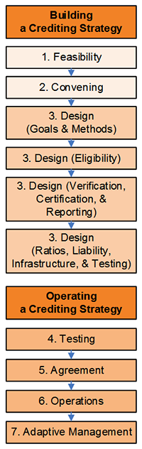
- Predictability in planning and implementing projects;
- Certainty that conservation goals are being met; and
- A more consistent way to track and account for conservation and development activities.
A transportation agency needs to understand the feasibility of expanding, adapting, or building a new ecosystem crediting strategy. A crediting strategy may not make sense for a transportation agency with simple, limited, or one-off effects on ecosystem services. Assessing feasibility will weigh what credit types are needed and when, what other ecosystem services should be tracked and communicated, who needs to approve credit purchases, and whether credits are available. Before building a new crediting strategy, a feasibility assessment helps consider whether the demand for credits, policy context, scientific information, supply of creditable projects, and support and participation of local leaders will be sufficient to make the strategy work.
A large part of building an ecosystem crediting strategy is managing for various forms of risk. The ecological, economic, and social systems transportation agencies work in are often dynamic. Uncertainty exists in how to measure the ecological benefits of restoration, the cumulative effects of small impacts, and how mitigation projects will perform over time. Over the course of planning and constructing transportation projects, and implementing credit projects, regulations and rules can change, staff can come and go, and other project elements change. An ecosystem crediting strategy can help clarify the sources of these risks, and put tools and processes in place to manage them.
Past efforts to build and operate crediting strategies helped identify a concise set of phases to ensure that the sequence of work and stakeholder engagement is effective and efficient. Those phases are summarized in Figure i. below. The rest of the document is structured to walk transportation agencies through each phase.
Feasibility: Making sure there is adequate demand and supply for credits to justify an ecosystem crediting strategy, and ensuring the science, policy, and people can be in place to successfully operate a crediting strategy.
Convening: Understanding which stakeholders need to be involved and when, what roles they might play, and what process is needed to reach agreement on an ecosystem crediting strategy.
Design: Building the crediting strategy to clarify goals and tools to quantify ecosystem credits, set rules for which projects can generate credits and which projects can use credits, and how to confirm and track the performance of credit projects over time.
Testing: Taking the quantification methods and other elements of a crediting strategy out for a trial run prior to full agreement and implementation.
Agreement: The process and form of agreement needed from regulatory agencies and other stakeholders to use a crediting strategy.
Operations: Setting up a governance structure to oversee the crediting strategy and establishing a process to price and purchase credits. Operations also include providing the documents and training for the people generating and using credits.
Adaptive Management: A structured process for improving a crediting strategy so it runs efficiently, is using the best available science, and is meeting the goals of the transportation agency and stakeholders.
Building and operating an ecosystem crediting strategy is not always simple, but it is doable. The elements described in this document are intended to help new crediting strategies build on past efforts and get a head start toward success.
↑ Return to Table of Contents, Appendix B
↑ Return to Table of Contents, Report
Preface
The Integrated Ecological Framework (IEF) is a tool to integrate conservation planning and transportation planning for Departments of Transportation and Metropolitan Planning Organizations. IEF Step 6 proposes the development of a crediting strategy, which allows agencies to use a programmatic approach to measuring impacts and mitigation, including tracking, approving, and acquiring multiple types of ecosystem credits that can be used to offset the impacts of transportation projects. Ecosystem credits can be generated from mitigation and conservation banks, funding set-asides, land grants, in-lieu fee programs and many other examples. Credits are established to provide ecological protection more broadly than specific to a project site. A crediting strategy can provide transportation agencies with the predictability needed to plan and implement projects, regulatory agencies and the public with more certainty that conservation goals are being met, and overall a more consistent way to track and account for conservation-based debits and credits.
Credits and Debits Defined
For this document, an ecosystem credit is a unit of ecological benefit measured in terms meaningful to potential buyers who need to offset impacts (debits), or who want to quantify and track the ecological benefit of their investments. A credit can be a bundled set of services from a particular ecosystem (e.g., an acre wetland credit), or a single service (e.g., a pound of phosphorous reduction credit).
Transportation agencies building a crediting strategy need not start from scratch. Based on experience developing credit accounting protocols for both regulated and non-regulated but important resources, a basic framework of processes and tools has been identified that can be adapted to address local issues, geography and political needs. The framework, described in this guide, includes:
- Evaluating the feasibility of a program,
- Convening the right group of stakeholders,
- Designing the crediting strategy itself,
- Securing some form of approval from regulatory agencies,
- Pilot testing and then implementing the strategy, and
- Setting up an adaptive management approach that will allow for improvements and fine tuning along the way.
This guide is a resource for building a crediting strategy. It is essentially a manual for new or emerging programs that outlines how to move through the phases of crediting strategy development and provides milestones within each phase that will help strategy designers identify and plan for the resources and work required to walk through the process. The guide will help transportation agencies and MPOs building new crediting strategies to reduce program start-up time, increase efficiency, and build the base of trust necessary to locally adapt and implement the Integrated Ecological Framework.
↑ Return to Table of Contents, Appendix B
↑ Return to Table of Contents, Report
I. What Is an Ecosystem Crediting Strategy and Why Build One?
An ecosystem crediting strategy is a more consistent, programmatic approach to measuring, tracking, approving, and acquiring multiple types of ecosystem credits that can be used to offset the impacts of transportation projects. A strategy can also be a structured way to evaluate different alternatives for mitigating unavoidable ecosystem impacts.
In an ideal world, agencies and stakeholders work together to develop an integrated crediting strategy for multiple natural resources across an entire state. In reality, however, key pieces of a functioning strategy are absent in most places. In those cases, transportation agencies need to decide whether to do the best with what they have, borrow elements of a crediting strategy from elsewhere, or develop elements of a strategy specific to their needs. There are pros and cons to all of these approaches.
A functioning crediting strategy will generally need four major components:
- Quantification tools: The models and methods needed to quantify impacts to ecosystem services from development actions (debits) and to quantify benefits to those services from conservation actions (credits). Quantification tools need some level of calibration for local conditions and approval from applicable regulatory agencies. Tools can be as simple as a set of crediting ratios or mitigation site performance standards, or can involve complex hydrologic and water quality modeling.
- Protocol for creating and tracking credits: A crediting protocol defines the criteria for which impacts are eligible to purchase credits, what mitigation projects can generate credits, and how credits should be tracked and accounted for over time as they are bought, sold and/or retired.
- Regulatory approval process: Most crediting strategies will be focused on meeting regulatory requirements, and therefore will require approval from appropriate regulatory agencies. In almost all cases, that approval will be formal, memorialized through some type of written agreement between regulatory and transportation agencies. Approvals may be more or less formal, may be a multi-agency agreement, or could take the form of standard operating procedures within individual agencies to improve consistent use of a crediting strategy.
- Credit procurement process: A crediting strategy will also need to define the different ways a transportation agency might secure the credits they need. This could include creating credits themselves (i.e., permittee-responsible mitigation), working with contractors to implement projects, and/or purchasing credits from a mitigation bank or in-lieu fee program. Each procurement strategy works well under different conditions.
Throughout this guide, callout boxes present key milestones and considerations that local groups should aim and plan for when developing crediting strategies. These considerations include approaches that have been successful in one or many current programs and will help groups to budget the time and resources needed to complete each phase of developing a crediting strategy.
Groups building crediting strategies often underestimate
- the time and the resources required to assess feasibility and convene the right stakeholders; and
- the resources required for ongoing operations and adaptation of the crediting strategy.
Whether designing a complex program for multiple buyers or sellers, or putting together a deal between one buyer and one seller, the same basic steps are generally repeated for crediting strategies throughout the country. Each of the following phases requires attention depending on the specific needs and characteristics of a watershed:
Feasibility: Making sure there is adequate demand and supply for credit to justify an ecosystem crediting strategy; and ensuring the science, policy, and people can be in place to successfully operate a crediting strategy.
Convening: Some of the most important work in building a crediting strategy comes in convening and preparing the right group of stakeholders necessary for creating and operating the strategy.
Design: The design phase turns a feasible opportunity into a reality. Important aspects of this phase include building the science to connect environmental benefits to unavoidable transportation impacts, and creating the policy to shape who can buy credits from whom and how.
AgreementA strategy needs some level of stakeholder agreement to move from the design phase to becoming a fully active strategy with actual credit transactions. In almost all cases, that approval will be formal, memorialized through some type of written agreement (e.g., a Memorandum of Agreement) between regulatory and transportation agencies to ensure solid legal and policy footing for use of a crediting strategy.
Testing: Elements of the strategy might need to be tested prior to use. This could include repeatability and sensitivity testing of quantification methods, as well as gathering and synthesizing stakeholder input.
Operations: Often, most energy is focused on strategy design, but operating a successful strategy over time requires flexibility, careful planning, a range of skill sets, and potentially different groups of stakeholders. The Operations phase might include rolling out a pilot version of the strategy’s quantification methods and protocol documents, identifying a Strategy Administrator to see projects through the credit issuance process, and maintaining and improving the strategy over time.
Adaptive Management: No strategy is perfect; every strategy will need adjustments, particularly in the first few years of operation. Successful strategies include structured ways in their design to gather lessons learned, catalog needed improvements, and make regular adjustments on a predictable schedule.
Figure 1.1 describes some of the key phases and associated milestones in building and operating an ecosystem crediting strategy. The sections below provide detail on each of these phases and milestones.
Figure 1.1: The phases and milestones for building and operating an ecosystem crediting strategy
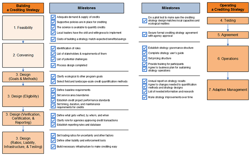
508-compliant HTML representation of this image →
↑ Return to Table of Contents, Appendix B
↑ Return to Table of Contents, Report
II. Phase 1: Feasibility—Is a Crediting Strategy the Best Approach?

An ecosystem crediting strategy will not be the best approach for every situation. Assessing feasibility lets a transportation agency understand if a crediting strategy makes sense, and then lay the groundwork for successfully building and operating a strategy. Much of building a crediting strategy involves navigating through inconsistencies in existing policy, uncertainty in science, and the different perspectives of multiple stakeholders. Successful navigation through these issues can inform how other community-based approaches (e.g., targeted landowner incentives or coordinated land use practices) to conservation might work.
Significant time and resources have been expended building and testing crediting strategies throughout the U.S. (see Framework 2), giving rise to the program elements and process steps necessary to develop a successful strategy. While there are many common aspects, the place-based nature of ecosystem crediting requires significant customization to suit the economics, environmental conditions, and political context of the location or jurisdiction within which the strategy is being implemented. The challenge for transportation agencies and their stakeholders is to move through those process steps efficiently while managing diverse needs and goals, understanding sophisticated scientific concepts, and assessing the economics needed to make crediting transactions work.
The Pikes Peak Area Council of Governments (https://www.ppacg.org) in the Colorado Springs area of Colorado is developing an Advanced Integrated Regional Mitigation Plan to address mitigation requirements related to the Endangered Species Act. The COG has a performance measurement framework with ecosystem goals measured in acres, for “minimizing environmental impacts” and also for “improving, protecting and mitigating impacts of critical habitat and connecting corridors suitable for threatened, endangered, and imperiled species.” The framework supports the measurement of habitat impacts (debits) and benefits (credits). In addition to the ESA, Clean Water Act regulations present an opportunity to develop a similar approach to mitigation requirements for impacts to water quality, wetlands, streams.
One of the first tasks for transportation agencies embarking on the development of a crediting strategy is an assessment to determine which of the four strategy components have already been used in their geography for the ecosystem services of interest.
Assessment of existing crediting strategies requires an understanding of:
What credit types are needed and when? Determining what credit types (e.g., wetland function, endangered species, water quality) are needed will help focus the search for applicable crediting strategies. Many components for crediting strategies have been built for single ecosystems, and many for specific states, species, or watersheds. For example, North Carolina’s Ecosystem Enhancement Program works for multiple credit types, but may not be immediately transferrable to the Southwest. A credit quantification method measuring prairie dog impacts will need to be adapted to quantify impacts to pocket gophers.
The timing of when each credit type is needed is also important. If credits are needed within 3 months to complete a project, the range of options to meet that need will be different than if credits are required in 12-24 months. Finally, understanding the approximate quantities of each credit type can help determine how much effort to put into borrowing and adapting a crediting strategy versus building one. For example, if an interchange project is likely to need credit for a localized endangered species that is very unlikely to occur elsewhere on the transportation system, it might be more straightforward to mitigate for that impact at the project scale rather than include that credit type in a programmatic crediting strategy.
Are ecosystem services established for other reasons? In addition to purchasing credits, there may be ecosystem service benefits or impacts a transportation agency wants to highlight for other reasons beyond mitigating regulated impacts. For example, possible new stormwater or other water quality rules may drive an interest in tracking how stream mitigation projects improve water storage and delay, nutrient reductions, etc. Agency or state climate strategies may create an interest in tracking and communicating the carbon sequestration value of wetland mitigation projects. Tracking other ecosystem services can be an important way to build a case for lower project risk, or communicate to the public about the broader value of transportation projects. Note that tracking ecosystem services outside the regulatory arena may demand a different standard for approvals of crediting strategy components.
Who needs to approve or agree to the purchase of credits? If there are existing components of a crediting strategy in place, specific approval from regulatory agencies to use those components in an agency-specific crediting strategy may still be required. For example, or county may have a Habitat Conservation Plan (HCP) in place with an associated crediting strategy, but specific approval from USFWS may still be needed to use or adapt that HCP for state transportation mitigation purposes.
Are credits available in the right service area? Even if all the regulatory approvals and crediting strategies are in place, there still need to be the right types of credits available in the right service area. Regulatory agency staff should understand where mitigation and conservation banks are available, and whether in-lieu fee programs are an option. In many cases, the right type and quantity of credits are not immediately available, but could quickly come online if providers knew there was a need.
If you have determined that there are existing credits or crediting strategies to build upon, Section 2.1 outlines how to use and adapt those strategies for your specific objective. If you determine there is a need to build new crediting strategies, Section 2.2 Assessing the Feasibility of Building a New Crediting Strategy, describes those steps in detail.
↑ Return to Table of Contents, Appendix B
↑ Return to Table of Contents, Report
2.1. Using and Adapting Existing Strategies
Using existing crediting strategies makes sense whenever possible—especially when they are fully developed for the credit types and geographies of interest. Using existing strategies can reduce start-up time, re-invest in strategies that already have some stakeholder buy-in, and help improve consistency if many groups are using the same or similar strategies.
Yet, there are sometimes reasons not to use existing strategies. In many cases, existing strategies are incomplete (e.g., a wetland crediting strategy exists, but an endangered species crediting strategy does not) and it can be a challenge to get a regulatory agency to approve the crediting strategy of a different agency. It can also be difficult for a federal agency in one region to approve a crediting strategy from the same agency in a different region. In these cases, it can be easier and faster to build or re-build a crediting strategy using the lessons from the existing strategies. Existing strategies may also not incorporate the latest information on conservation goals and priorities, and could therefore be inconsistent with the information developed under IEF Steps 1 and 2.
More than likely, existing strategies will need some adaptation to local needs. The same kinds of questions need to be applied when adapting a strategy. Do stakeholders support existing strategies? How applicable are the scientific assumptions and data built into the crediting strategy to be adapted? Are there other barriers to adapting a crediting strategy that make it easier to build something new?
↑ Return to Table of Contents, Appendix B
↑ Return to Table of Contents, Report
2.2. Assessing the Feasibility of Building a New Crediting Strategy
Part of assessing existing strategies will be the identification of what is missing. The next steps can help figure out what level of effort will be required to fill those gaps, who should fill them, and which gaps to fill first. A feasibility assessment can be rapid and simple or go much deeper depending on how much information a transportation agency needs in order to make decisions on a crediting strategy. Components of a feasibility assessment include the determination of:
Thinking Through Feasibility in Colorado
http://www.cnhp.colostate.edu/download/
documents/2012/C21_finalreport_august2012.pdf
In 2012, Colorado State University tested the use of the SHRP 2 C06 Integrated Ecological Framework (IEF) for integrating conservation into transportation planning and project development. As part of this effort, the research team conducted an ecosystem service crediting assessment to address:
- What ecosystem services are most likely to be impacted (positively or negatively) by transportation projects,
- Whether banks or other markets exist for these affected ecosystem services, and
- If there are markets needed for the affected areas can we adopt approaches used in other regions of Colorado (Kagan et al, 2014).
-
Is there adequate demand? There are two types of credit demand: potential and actual. Potential demand can be estimated based on total projected impacts. Actual demand is often less than potential demand because of onsite avoidance and minimization, change or delay in project implementation, and other operational factors that reduce the total credit demand. Getting to actual demand might involve talking with other staff within the transportation agency or initiating early conversations with regulatory agencies.
It is assumed that a transportation agency knows the type, timing, quantity, and location of credit demand. This information is important for designing regulatory approval processes and establishing timelines for completing a crediting strategy. In some cases a transportation agency’s demand alone may be enough to justify building a programmatic crediting strategy. In others, demand for credits from other sources may bolster that need or effort.
Some relatively quick ways to understand demand for ecosystem service credits include:
- Review Clean Water Act 404 permitting activity in the last 5 years for target watersheds;
- Identify new TMDLs or statewide water quality limits, and the likely changes needed within NPDES permits (municipal, industrial, and MS4) needed to comply with those limits;
- Review existing Endangered Species Act consultations and/or HCPs for target regions;
- Consider other localized mitigation requirements that might generate demand for credits; and
- Explore growth estimates to project where future infrastructure and development needs might also result in impacts that would create demand for credits.
-
Are supportive policies are in place for crediting? Ecosystem crediting to meet compliance needs for a transportation agency will not work without support from regulators at the federal, state, and local levels. During the feasibility stage, it is necessary to secure some indication from these agencies that they support the concept of crediting, and that they are willing to participate in crediting strategy design. This includes confirmation that the required legal authorities for crediting are in place where they exist. It can be helpful if those building the crediting strategy work with agency staff to explore existing authorities to see what is “allowed,” what needs “further exploration,” and what is “not allowed.” Without agency support, credit buyers and sellers will be hesitant to invest.
At the state level, agencies may have statutes, regulations, policy, or guidance governing crediting. These policies provide a legal foundation to issue permits with crediting provisions. The clearer those rules and guidance are, the more predictable crediting will be.
-
Does the science exist to support quantification of credits? Science informs the development of a crediting strategy in several ways. First and foremost, it helps shape the overall environmental goals and objectives of a crediting strategy. Science is also used to quantify potential credits from land management activities in terms that allow potential buyers to compare crediting to other compliance alternatives.
From a trust and transparency perspective, there is great value in having consistent methods for quantifying credits. Quantification methods can include models (both simple and complex), standardized best management practices (BMPs) or crediting ratios, and use of best professional judgment. Crediting strategy design costs are greatly reduced if these quantification methods are already available and require minimal adaptation as developing new quantification methods can consume a large percentage of the budget and time available for strategy design.
This guide assumes that previous steps in the IEF process have identified most of the science required to quantify credits. Some of the characteristics of site-level credit quantification tools are provided below. The following points are adapted from Measuring Up (Willamette Partnership, 2011).
Good credit quantification methods should:
- Incorporate the landscape context of site (e.g., location in a priority conservation area, potential threats, connectivity, patch size, etc.);
- Be valid (e.g., repeatable, sensitive, accurate, and transparent);
- Be practical, economical, and easy to use; and
- Be applicable at different scales (e.g., a 1-acre wetland or a 10,000-acre sagebrush steppe).
A good method should be linked to outcomes and incentivize the kinds of actions that will lead to a region’s overall ecological goals. Ideally, methods can give information about both specific elements of an ecosystem as well as its whole. For example, a stream function assessment methodology might give one score for overall stream function, but generate individual scores for the geomorphological, biological, hydrological, and chemical functions of a stream.
A catalogue of potential quantification methods that:
- quantify environmental impacts and benefits at the site level, and
- quantify the effect of actions to the broader landscape or watershed can be identified early on.
That list of potential methods should specify any validation, calibration, or other adjustments needed to adapt methods for local use. Regulatory agencies may have already selected methods that they will require. Experience shows that there is a strong tendency with local groups to want to build methods from scratch for their local situation. The feasibility assessment should question whether that customization is necessary, especially for transportation agencies that need tools state- or region-wide. Building from existing work can reduce costs and increase consistency across programs.
-
Is There Adequate Credit Supply? For a crediting strategy to be effective there needs to be an adequate supply, or potential supply of credits in the right place and time to meet credit demand. Credit supply can come from nearly anyone conserving, enhancing, or restoring ecological value. Some potential sources of supply include:
- Landowners installing habitat or water quality best management practices;
- Mitigation banks;
- Nonprofits or private firms implementing restoration on contract with transportation agencies;
- Transportation agencies acquiring habitat to protect or doing restoration; and
- Anyone else who is generating ecological benefit above and beyond what would have occurred if not for the possibility of creating credits.
In general, there may be 1-3 years of lag time from when demand levels are definite to when supply is available. For example, it may take the equivalent of a planting season to recruit a farmer to commit to generating stream or wetland credits, then a year to get regulatory approval of a mitigation bank, and then six months to implement eligible restoration activities. A feasibility assessment should look closely at the timing of when supply can be available compared with key benchmarks for when buyers need to have credits in hand.
North Carolina Ecosystem Enhancement Program (EEP)
https://files.nc.gov/ncdeq/Water%20Quality/Planning/BPU/BPU/Lumber/Lumber%20Plan/2010%20Plan/Chapter%2011%20-%20EEP.pdf
The EEP was established in 2003 primarily to help NC Department of Transportation (NCDOT) meet its Clean Water Act 404 requirements for wetlands and stream mitigation. EEP is a cooperative effort between the Army Corps, NC Department of Environment and Natural Resources, and NCDOT. The program engages public and private partners to provide mitigation, and has expanded so other developers can use the program to meet its mitigation needs. The EEP now also supports water quality crediting.
To assess supply, transportation agencies need to know:
- The types of conservation actions and landscapes that can meet their credit demand (See IEF Steps 4-5). Similar to demand, there is a difference between potential and actual credit supply. IEF Steps 4-5 provide methods to assess potential supply—the places with important natural resource value and estimates for potential acreages and credit types available;
- How many credits are currently available in existing projects and mitigation banks;
- Since most transportation projects involve permanent ecological impacts, mitigation will often require long-term assurances and protection. A feasibility assessment should evaluate the patterns of land ownership and how willing people are to provide access to land for mitigation;
- Information on land values and credit prices; and
- Availability of third parties (e.g., mitigation bankers, local governments, or conservation districts) to provide technical assistance and/or aggregate credits to deliver as a package.
-
Are there local leaders with the capacity, skill, and willingness to help implement a crediting strategy? It is rare that a transportation agency or individual regulatory agencies will be able to implement all aspects of a crediting strategy by themselves across their entire service territory. Local stakeholder organizations and inter-agency cooperation can play an important role in designing a strategy, interfacing with regulatory agencies, delivering credits, and operating other parts of a crediting strategy. Part of assessing feasibility includes identifying stakeholders and defining roles stakeholders might play during convening, crediting strategy design, and strategy operations. Vaguely defined roles create uncertainty, which can slow strategy design and implementation. It is important to establish early on who will act as the local convener, who will lead crediting strategy design, and who will be responsible for administering the crediting strategy later on. Each of those roles requires different skills sets:
- Conveners need to have strong process and facilitation skills and legitimacy in the eyes of multiple stakeholders, with the ability to effectively bring stakeholders together.
- Crediting strategy designers need to have an expert technical understanding of ecosystem dynamics and relevant regulations (e.g., Clean Water Act and Endangered Species Act), as well as process skills that will help local stakeholders articulate a vision for the crediting strategy, prepare stakeholders for required decisions, and complete the design process in a timely manner.
- Strategy administrators need the administrative skills and legitimacy to sustain operations of a crediting strategy, which includes understanding of existing policies and regulations, risks and liabilities associated with administering credit transactions, and the ability to sustain trust from stakeholders.
One or more organizations may fill these leadership roles, but having “champions” to help crediting strategies move through various hurdles is critical. A state regulatory agency and/or transportation agency can be a good leader as long as transportation, environmental groups, and other key stakeholders trust agency staff. In some instances, a non-profit organization or a coalition of organizations could effectively fill the leadership role. Finding those leaders might involve determining who has regulatory authorities, which groups have a trustworthy public profile, which organizations have staff with experience bringing stakeholders together, and which organizations other key stakeholders point to as leaders in the field. Separating the financial side of transactions (e.g., buyers, sellers, and their agents) from the oversight roles (e.g., regulatory agencies, verifiers, strategy administrators) can help avoid potential conflicts of interest.
Milestone - Feasibility Assessment
Identification of potential quantification methods; identification of strategy leaders; assessment of demand and supply; and assessment of agency interest and support. With this information, the group is prepared for the convening work ahead.
↑ Return to Table of Contents, Appendix B
↑ Return to Table of Contents, Report
III. Phase 2: Convening Process for a Crediting Strategy

The reality of ecosystem crediting is that many credit transactions and/or permits can be challenged. As a result, both regulatory agency and broad stakeholder support is important. A successful process to build a crediting strategy depends on the right stakeholders fulfilling the right roles and on cultivating crediting champions during the process itself. Face time spent with each stakeholder before and during convening can help refine process design, flag issues for conversation, and build each stakeholder’s ownership of the process and resulting decisions (Emerson et. al., 2003). The questions below are examples of ones that can be asked and then revisited/reinforced during the convening phase.
Questions to Answer as Part of a Convening Report
- What should a crediting strategy do? What should it not do?
- In two years, how will it be determined successful or not?
- Who should be part of the discussion and when?
- What do stakeholders need to participate effectively and reach agreement?
- What is the right process for accomplishing those goals?
A convening report that captures this information provides a good reference point for strategy designers down the road. Documentation of the effort should be transparent and inclusive. The end product of the convening phase should be a workplan that articulates who will be involved, what their respective roles and responsibilities will be, and what the crediting strategy needs from each stakeholder. This workplan should map out at least the first year of crediting strategy operations.
Before meetings begin, each stakeholder should have an understanding of the goals of the crediting strategy, how the process can benefit them, as well as other stakeholders’ interests and motivations for participating. White papers can be used to brief stakeholders on these details prior to the first group meeting. Because regulatory agencies will need to approve all or portions of a crediting strategy, they will also need to be involved throughout this process. Including regulatory agencies will help ensure consistency with existing interpretations of state and federal statutes, rule, guidance, and standard operating procedures. Early engagement with agencies might also identify needed changes to agency policies or practices to ensure the crediting strategy works as desired.
Ultimately, the collaborative process should 1) build direct relationships between buyers and sellers of credits, 2) enable business and environmental interests to have candid conversations about, for example, overall goals for their watershed, 3) safeguard the interests of the broader community and people not directly involved in the process, and 4) ease organizational adoption of agreements made by the stakeholder group. Some excellent guidance exists on the principles and practice of collaborative decision-making.1
3.1. Who Should Be Involved?
Interagency Review Teams
The 2008 Compensatory Mitigation Rule (U.S. EPA/US ACE 2008) calls for interagency review teams (IRTs) to review mitigation proposals.
Many U.S. Army Corps Districts have established IRTs. A convening report can assess whether the IRT group can help build and operate a crediting strategy, or whether broader stakeholder involvement is needed.
Different phases of designing a crediting strategy will involve different groups. Essential groups usually include representatives from state/tribal regulatory agencies, local representatives of federal regulatory agencies, other credit buyers, credit sellers, environmental groups, and technical experts on ecosystem dynamics, farm practices, etc. The convening process helps strike the balance between inclusion of key stakeholders and keeping a group to a manageable size. Not everyone needs to be involved in every decision. Criteria to consider when drafting a list of individuals within those organizations include:
- Which agency issues permits, and who else has to say ‘yes’ to a crediting strategy (e.g., who will be signing agreements)?
- What resources/skills does the organization/individual bring, and where are those best used?
- Is the individual in the organization positioned as a liaison to check details with technical staff, but also able to present policy decisions to directors?
- Does the organization/individual have the availability and financial resources to participate effectively in collaborative settings?
- Is the organization or individual trusted by others? Trust is not simple to evaluate, but can come out through interviews. Some questions around trust might include, who really considers the interests of others when they make decisions, who consistently follows through on their commitments, or who works really well in collaborative settings?
Not all stakeholders need to be involved in all parts of strategy design. Good process design will provide multiple opportunities for participation, but will ask appropriate questions of the right groups of people. For example, it may not make sense for a group of policy leaders to review the methods to quantify credits, or for hydrologists to develop the mechanisms to determine credit prices.
↑ Return to Table of Contents, Appendix B
↑ Return to Table of Contents, Report
Willamette Partnership’s General Crediting Protocol
https://willamettepartnership.org/general-crediting-protocol/
In 2008, with funding from the Natural Resources Conservation Service, Willamette Partnership began convening work on their General Crediting Protocol. The objective was to bring together all the federal and state agencies who write or comment on permits, environmental groups, potential buyers of ecosystem services, and potential sellers together in a room to agree on a common set of metrics and protocols to govern a regional ecosystem market.
Willamette Partnership spent more than three months interviewing potential stakeholders, carefully constructing process elements, and developing agendas for meetings. When the stakeholders first met as a group in 2009, the Partnership knew the issues for each individual, could articulate decision points needed at each meeting, and clarify the ultimate outcome at the end of the process in eight months.
3.2. What Do You Need from Stakeholders?
Before stakeholders begin actively meeting, they should have a clear set of expectations in terms of their role in the process, as well as what their role might be in a crediting strategy going forward. This includes being clear on the number of meetings and time commitments expected. If the crediting strategy agreement will be requesting formal approval and signatures from stakeholders, people should know that early on.
Meetings need an agenda and purpose. Meetings will be most effective when strategy designers can clearly communicate exactly what is being asked of the group as a whole and have a schedule looking ahead to future decisions/requests, ensuring that group members have time to communicate with their technical staff and directors as necessary.
Some examples of what a crediting strategy might need from some stakeholders:
- Regulatory agencies: Regulatory clarity and formal approval and use of a crediting strategy if appropriate;
- Buyers and Sellers: Assurance the crediting strategy meets their needs and commitment to purchase or supply credits using the crediting strategy if appropriate; and
- Technical experts: Assurance that the crediting strategy provides real, verifiable credit transactions that do not compromise environmental quality.
- Broader stakeholders: A recognition that crediting strategy decisions and processes are transparent and responsive to stakeholder interests.
↑ Return to Table of Contents, Appendix B
↑ Return to Table of Contents, Report
3.3. How Do You Deal with Process Adversity?
With the diversity of stakeholders involved in developing a crediting strategy, some level of conflict can be expected, either from within the stakeholder working group or external to the stakeholder group. These internal and external challenges can be handled much more easily if they are anticipated and planned for early on in the process. Below are some common challenges experienced by crediting strategies with some ideas on how to prevent or deal with them.
Internal process challenges: It is common for stakeholders from different agencies, with different mandates and different expectations, to have misconceptions about how crediting strategies work and about the roles of various stakeholders. The convening phase can help reduce these misconceptions through individual conversations with various stakeholders outside of group settings.
Issues often arise when groups are getting down to the final stages of reaching agreement, where implications of engaging in crediting and associated responsibilities start to become real. If individuals have been minimally engaged and have not been part of the decisions made by the group, the last meeting is likely where they will raise objections or put up roadblocks. To avoid this scenario, it is essential to clearly outline the level of commitment required to be involved in the process, get clear commitments upfront from stakeholders, and hold them to their commitment.
External process challenges: Challenges that come from sources external to the process are more difficult to manage. A stakeholder who was left out of the working group can end up being a vocal critic of either the process or the outcomes. It is important to ensure that there is a venue or mechanism to acknowledge the ideas or issues being raised by people who are not part of the initial stakeholder group. This can be a planned series of presentations, question and answer sessions, or thinking ahead about how to add people to the stakeholder group mid-process, if necessary. Public access to the project (e.g., a project website) increases transparency and can help mediate critics.
Another challenge can come from changes in key agency or other stakeholder staff. This requires that:
- a new person be brought up to speed on the technical details and decisions already made, and
- the convener/organizing group ensures a smooth transition as a new person enters a group process already underway.
As a group goes about designing a crediting strategy, they should always have their ear to the ground for signs of changing economic, political, or legal conditions that may be relevant to their work (e.g. an election, lawsuit, or bankruptcy of a key buyer). This means building relationships with individuals in regulatory agencies and with local and state government officials that can provide some advance indication as well as guidance for what the changing conditions mean.
Potential Stakeholder Groups to Guide Design of a Crediting Strategy
Strategy Design Team (Strategy Designers): A lead team that oversees all strategy design elements and day-to-day activities. A team will be most effective when they have relevant policy knowledge, good working relationships with each stakeholder, excellent process and project management skills, and nearly full time dedication to the project. This role is best filled by respected staff of transportation agencies, regulatory agencies, or third parties, who are able to build trust, discuss stakeholder concerns in confidence, remain stable in changing political climates, and nimbly adapt to stakeholder needs. A consultant hired with public funds may also fill this role.
Stakeholder Working Group: The key group that forms and approves the details of the crediting strategy. This group is broadly representative of local stakeholders, but not too large to manage (e.g., about 10-30 members). Working Group members must be in a position to act as a liaison to the organizations they represent—ideally, in a middle position close enough to check details with their technical staff, but also able to present policy decisions to organizational directors.
Most importantly, Working Group members should be their organization’s representative with the best working relationships with other members of the Working Group and Strategy Designers. With larger stakeholder groups, it will likely be important to create a small executive committee, or a Coordinating Team, of the few (e.g., 4-8) most engaged Working Group members that reviews work between meetings, guides Strategy Designers, and helps move decisions along.
Coordinating Team members should have availability to meet regularly and spend significant time working as a group and reaching out to other stakeholders. This group can identify and articulate potential directions and decision points for the larger Working Group. Work includes drafting briefing papers and organizing project tasks and Working Group meeting agendas.
Technical Groups: Small groups that make detailed recommendations to the whole Working Group (e.g., credit quantification methods, finance, setting trading ratios, or software tools). Technical Group members can be both Working Group members and outside stakeholders with the best working knowledge of the technical task at hand. “Technical” is not just limited to science expertise. It can include expertise on pricing and financing, process improvement, etc.
Policy Group: If necessary, organizational policy leaders that can be convened to adopt decisions or provide direction to the Working Group. The policy group or the Working Group might also help resolve conflicts.
Milestone - Convening
Understanding by all participants of the scope and scale of the project and the commitments needed to secure approval and move the crediting strategy design into operation. With this information, the group is prepared for the substantive design work ahead.
↑ Return to Table of Contents, Appendix B
↑ Return to Table of Contents, Report
IV. Phase 3: Designing a Crediting Strategy

All the work completed to assess feasibility and convene the right stakeholders sets the stage for successful crediting strategy design. The substantive work of design includes confirming environmental goals, developing methods to quantify credits, creating a protocol of policy assurances and crediting rules, implementing pilots to test the strategy design, adapting to new data and needs, and finally, transitioning to strategy implementation.
Forms of Uncertainty to Address in a Credit Issuance Process
“Will crediting help achieve environmental goals” is a question full of uncertainty. Reducing risk and uncertainty is so essential, that this report treats many parts of a credit issuance process as tools to deal with uncertainty. Several forms of uncertainty exist including:
- Substantive uncertainty comes from limited scientific understanding of how ecosystems work and what it takes to improve them. For example, will a buffer strip reduce nutrient loads by 30%?
- Strategic uncertainty is generated by interactions among multiple stakeholders. Will stakeholders participate in good faith? Will a mitigation banker go out of business, or will a farmer maintain a BMP for 10 years?
- Institutional uncertainty stems from changing regulations and ways those rules are interpreted. Will a lawsuit change the definition of baseline requirements?
Uncertainty generates risk (including the perception of risk), which can keep buyers, sellers, and other parties from embracing a crediting strategy, increase credit prices or transaction costs, or otherwise keep a strategy from meeting its goals.
Ideally, previous IEF Steps 1 and 2 have clarified goals for a crediting strategy. It may be important as part of design to reinforce or reiterate those goals. Shared goals provide both a foundation and touchstone that make design decisions easier. Similarly IEF Steps 4 and 5 should have identified methods to quantify credits and debits. The relevant regulatory agencies will need to have accepted the use of selected methods within the crediting strategy. If quantification methods have not yet been selected, crediting strategy design leads may establish a technical group of interested stakeholder group members and outside technical experts to evaluate and guide the details of a specific quantification method.
A credit issuance process is the backbone of a crediting strategy. Design elements woven through a credit issuance process screen crediting projects for eligibility, adjust credit quantities with trading ratios, verifies that credits are real, keeps track of transactions, and provides for ongoing monitoring and assurances that credits provide ecological value over time. Reducing various forms of risk and uncertainty is a major emphasis of a credit issuance process.
4.1. Weaving Design Elements into a Credit Issuance Process
A credit issuance process helps inform all aspects of a crediting strategy and helps designers make tradeoffs and integrative decisions about where best to address different forms of uncertainty and risk present in crediting. The credit issuance process should incorporate the following elements:
- Eligibility screens to ensure a seller is eligible to produce the type of credits required prior to generating those credits and to get higher quality projects,
- Trading ratios,
- Performance, financial assurance, verification, and registration standards to ensure promised environmental benefits are achieved, and
- Contracts and insurance.
Building a credit issuance process can be done in three steps:
- Establish key elements of the credit issuance process: These are largely the same across different credit types and geographies. Elements include sellers determining their eligibility for generating credits, calculating environmental benefits, applying trading ratios, verifying to confirm accurate credit quantities, registering credits, selling credits, and finally settling into long-term monitoring and stewardship.
- Analyze sources of risk and weave risk management throughout the credit issuance process: Within each of the credit issuance elements above, there are different ways to address risk and uncertainty. Stakeholders will need to discuss which risk management tools best manage the risks they are most concerned about given the resources they have.
- Finalize a Crediting Protocol and other Documentation: A crediting protocol is a core document combining the chosen quantification methods with a credit issuance process in a complete protocol for creating, buying, selling, and tracking credits. Other documents might include manuals on applying methods, protocols for credit verification, monitoring frameworks, etc. (See Appendix B for a full list).
Development of a credit issuance process is necessarily a highly collaborative effort between strategy designers and stakeholders. In its entirety (see Figure 4.1), a design that deals comprehensively with risk builds confidence in all parties that the crediting strategy will achieve environmental goals as well as meet state and federal laws.
4.1.1. Eligibility Requirements
Eligibility criteria determine who can buy credits and who can sell credits. They also can define when credits can be sold (e.g., after meeting pre-established performance standards) and where credits can be sold (e.g., only to buyers within a service area). Eligibility criteria act as an early filter to make sure appropriate projects are generating credits and appropriate trades are occurring. Setting the level of eligibility is likely to be an iterative process, reflecting conservation objectives and market conditions.
Ideally, a crediting strategy would include an eligibility checklist that potential credit sellers can fill out, and be provided with some formal notification of eligibility before sellers invest too much time and money into developing their credit projects. An eligibility notice in response to getting a eligibility checklist from sellers gives them assurances to that they are able to generate some level of credit (see Appendix A for sample eligibility forms).
Preconditions to Purchasing Credits for Buyers
Transportation agencies and other buyers must take steps to avoid and minimize impacts prior to purchasing credits. Each permitting agency may interpret the mitigation hierarchy slightly differently. It is important to understand what other requirements must be met onsite for a given project prior to purchasing credits. These requirements are referred to as “baseline.” Baseline requirements can come from explicit regulatory requirements or from additional measures needed as part of a crediting strategy that go above and beyond regulatory requirements.
In some cases (e.g., stormwater crediting), transportation agencies may also need to demonstrate there are not localized impacts or “hotspots” caused by projects offset with credits purchased elsewhere. In addition, only some types of impacts or pollutants may be eligible to access a crediting strategy. Other impacts will need to be addressed onsite.
Figure 4.1. Design elements for each stage of the credit issuance process
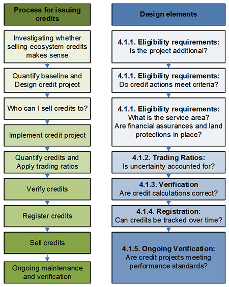
Preconditions for Generating Credits for Sellers
Not all land uses, ownerships, or conservation actions will be eligible to generate credits. A crediting strategy can facilitate approval of credit-generating projects by creating a pre-approved list of eligible project types for credits. For each project type (e.g., habitat enhancement, habitat preservation, or on-farm BMPs), there can be guidelines to fast-track approval of credits. Those guidelines can include:
- Criteria for site selection;
- Design standards to ensure quality implementation; and
- Maintenance and monitoring standards to ensure performance.
In some cases, these guidelines might already exist. For example, USDA Natural Resources Conservation Service has developed standards for many on-farm BMPs, DOTs and local governments have standards for stormwater BMPs, and many states have developed criteria for wetland mitigation.
Defining baseline requirements for credit-generating projects can be complex. There are several components to a seller’s baseline:
- Regulatory requirements with affirmative obligations (e.g., 100-ft setback requirements from streams);
- Broad regulatory obligations (e.g., requirement for a nutrient management plan); and
- Ecological improvements required to meet crediting strategy or other goals (e.g., contribution toward meeting TMDL nonpoint Load Allocations; implementation of BMPs to improve habitat as part of a Candidate Conservation Agreement with Assurances).
There are a lot of ways to set and express baseline requirements, but a crediting strategy should set clear expectations for which conservation actions are “additional” and can provide credit. Setting baselines should also identify timelines for when baseline obligations need to be met.
Finally, some funding sources may challenge a project’s ability to generate credits. Some states and some funding sources limit the ability to use public funds dedicated to conservation for mitigation. For example, projects funded by the Wetlands Reserve Program cannot create wetland mitigation credits in most instances. A crediting strategy will need to identify how public funds dedicated to conservation can or cannot be used to generate credits.
Trading or Service Areas
A crediting strategy should define eligibility for trades by defining trading areas or service areas. A trading or service area defines the geographic region where trading can occur and makes it clear to strategy participants which buyers and sellers can conduct trades with each other. Service areas can be based on watersheds, ecoregions, or other geographic areas and are often defined in regulatory documents guiding mitigation policy.
Setting a service area requires a balance between different factors. Of primary consideration is the ecological boundary within which it would be appropriate to offset an impact. For wetlands, stream function and water quality impacts, this may be the watershed or basin level; for terrestrial habitat impacts, it may be the ecoregion. Economic conditions are also important. Will there be enough buyers and sellers in a trading area to support trades? For trading to be economically feasible, there needs to be enough supply and demand of credits. Ecological considerations tend to push trading or service areas to be smaller while economic considerations push them to be larger (Womble and Doyle 2012). Political jurisdictions and preferences may also shape service areas. Groups designing or advising design of the crediting strategy for example may want to incentivize investment in their local community and not too far away from their infrastructure or facilities.
Challenges may arise in trading that occurs across state lines (i.e., in watersheds that cross those boundaries). U.S.EPA supports interstate water quality trading under Section 103a of the Clean Water Act that directs U.S.EPA to encourage cooperative activities by the states (U.S.EPA, 2007). Yet, interstate trading requires multiple state agencies to agree to common design elements, which can be challenging. States may also need to explicitly allow for impacts in their state to be offset with improvements in other states.
Timing and duration of credits
Different types of ecosystem credits behave differently. Generally, habitat credits are used to offset permanent impacts to habitat. Water quality credits are often used to offset an annual or seasonal discharge of pollution. As a result, each credit type has different characteristics. A crediting strategy will need to clarify how long credits are good for (credit lifespan) and what actions or conditions constitute the start of a credit lifespan. Some simple rules of thumb include:
- The credit lifespan should match the duration of the impact (e.g., a permanent credit for a permanent impact; an annual credit for an annual loading of pollution);
- Credits should not be issued until a verifiable action has been taken to create an ecological benefit (e.g., recording a conservation easement, getting a restoration plan approved, implementing on-farm BMPs, etc.); and
- Temporal credits creating benefit of one time period (e.g., in Spring 2014) should generally not be used to offset temporal impacts in another time period (e.g., Spring 2016), because this makes it difficult to value the equivalency of the benefits.
Some credit types can also be released in phases as performance standards are met. Performance standards for projects generating credits establish the ecological targets that need to be met prior to credit release. Performance standards should also help determine if project conditions are on track to support and deliver the ecosystem benefits consistent with the estimated credit amount. Ideally, clear performance standards and design specifications have been set early in the crediting strategy design to help save time and money. A sample phased credit release might look like:
- Phase I: Release X% on signing of a crediting instrument;
- Phase II: Release X% as major ecosystem enhancements are complete;
- Phase III: Release X% as interim performance standards are met; and
- Phase IV: Hold back X% until all performance standards have been met and all stewardship elements are in place.
Stewardship and maintenance requirements
There are very few credit-generating actions that will not require some level of stewardship and ongoing maintenance to provide promised ecological benefits—particularly in a world of invasive species and climate change. A crediting strategy should include an overall stewardship plan, and individual projects can either reference this plan and/or provide more project-specific details. Elements of a stewardship plan include:
- Who will do the near-term maintenance, and who will take over long-term stewardship;
- Stewardship cost estimates and a plan for providing those funds;
- If endowments are needed, the timing of when funds will be contributed, assumptions about return on investment, and descriptions for using interest and principal funds; and
- Contingency plans if projects do not meet performance standards either because of force majeure events or because of inadequate maintenance.
4.1.2. Trading Ratios
Trading ratios are discounts:
- applied to the total possible credits from a project, and
- applied to the total issued credits setting aside a portion held in reserve.
Ratios are used to account for uncertainty, dynamic ecological processes, and risk. Depending on a crediting strategy’s quantification method and other mechanisms to deal with risk, there may be more or less need to address uncertainty with trading ratios. Ratios are not always based on extensive analysis, but they should be based soundly in science and solid information. Ratios need to be defensible. A crediting strategy’s analysis of ratios should address the following questions:
- Do credit quantification methods adequately address a credit-generating project’s landscape context and processes relative to the impact site (e.g., attenuation of pollution through the watershed or habitat connectivity)? If yes, ratios may not be needed;
- Does the transaction require translating between different credit types (e.g., between phosphorous and sediment or between wetland and stream)? If no, may not need to address with ratios;
- How much uncertainty is there in current quantification methods, likely success of projects, and the ability of participants to follow through on their agreements? If very low, may not need to address with ratios;
- Is there a need to hold credits in “reserve” to manage risk of project failure? If no, may not need to address with ratios; and
- Is there a need to demonstrate net environmental gain? If no, may not need ratios.
Overall, many crediting strategies are trying to answer these questions within quantification methods or other protocol elements, leaving fewer issues to be addressed by trading ratios. Crediting strategies may choose to lump considerations into a single trading ratio or keep ratios separate. Either way, the total ratio should ensure a ratio greater than 1:1 (e.g., for every acre of habitat lost, at least one acre of habitat is gained). This rule of thumb acknowledges the certainty of loss with most impacts and the uncertainty of ecological gains for most crediting projects.
4.1.3. Verification and Certification Rules
Verification
Credits that are traded only have value if participants - buyers, regulators, sellers, and the public - are confident that sites are achieving the proposed environmental benefits. To this end, verification answers two general questions:
- Are project developers (sellers) complying with crediting strategy rules and procedures, and
- Is the site achieving performance standards established by the strategy?
A crediting strategy needs to clarify when and how often verification occurs (e.g., after as-built conditions are established and annually over the length of the credit contract). The first, full verification of a project confirms that the correct methodology is being used to calculate credits and that project conditions meet the minimum quality standards. Initial verification also confirms that credit calculations are accurate within some allowable margin of error (e.g., within +/- 15% in the case of Willamette Partnership programs) and might also confirm the information used to determine a project’s eligibility. In subsequent years, verification confirms that installed practices are constructed as designed and that maintenance is occurring as scheduled. Ongoing verification might include some combination of monitoring report review and field visits.
Verification can be conducted by agency staff, independent third parties, or by the buyers and sellers themselves, and it can vary in frequency, intensity, and information reviewed. In general verifiers should be familiar with the credit calculation methods and crediting protocols. Who verifies a project is an important consideration. Several strategies have used third party entities such as soil and water conservation districts or nonprofit organizations as verifiers. There needs to be clear guidance for identifying and avoiding conflicts of interest for those who act as verifiers. Ideally verifiers are accredited, trained, and included in ongoing updates to crediting strategy rules and tools.
Another important element of verification is a clear dispute resolution clause in case verifiers and buyers or sellers cannot agree on credit estimates.
Certification
Certification is the final review step before credits are issued. During certification a regulatory agency or other credit strategy administrator confirms that all documentation is complete and accurate. In some cases regulatory agencies may need to certify every credit- generating project. In those cases, verification and certification may be blended into the same process.
Agency involvement is important in this final stage, but state agencies may choose to approve the overall crediting strategy rather than individual projects. With certification in hand, a seller is ready to make trades.
4.1.4. Registration, Reporting, and Tracking
RIBITS
(https://www.lrl.usace.army.mil/Missions/Regulatory/Mitigation/RIBITS.aspx)
The US Army Corps of Engineers, US Fish and Wildlife Service, and now National Marine Fisheries Service will use the Regulatory In lieu fee and Bank Information Tracking System (RIBITS) to track all credits generated from mitigation and conservation banks. Not all credit types (e.g., water quality) are currently supported by RIBITS.
For a crediting strategy to work, a central database, or interconnected databases to track performance and transactions in a centralized way is needed. Several strategies are using a specific form of database called a registry. A registry facilitates a number of important tasks for a crediting strategy including project registration, credit issuance, credit serialization, and transfer of credits between accounts. It also provides a public view of the strategy. Some strategies may have low enough trading volume that a simpler database may suffice.
Standardization of reporting and tracking tasks increases the transparency and overall credibility of a strategy by ensuring that credits are only sold once. There is a balance between full transparency and privacy for landowners. Strategy participants and the public need to know projects performing as designed, and they need to know a contract is in place for the maintenance and monitoring of ecological conditions. They do not necessarily need to know the terms of that contract or all details of a project. The central database can keep public and private versions of documents, so long as the strategy has a clear policy on confidential information.
4.1.5. Liability, Enforcement, and Other Forms of Risk Management
Crediting strategies need to be clear on what happens if something goes wrong and who is liable. Liability rules will be different for different credit types. For wetland and conservation banking, buyers have the ability to transfer their permit’s mitigation liability to credit sellers. For water quality credits, the transportation agency will retain permit liability to offset their pollution load in many cases. As a result, a crediting strategy may need a combination of regulatory and contract liability tools to manage the different types of credits a transportation agency needs.
As part of stewardship, crediting strategies will have defined contingency plans if particular projects fail, but there are also ways to manage these risks programmatically.
A reserve pool is a centralized cache of issued credits intended to cover risks in the market; it can be drawn upon to compensate for unexpected project failure associated with force majeure (catastrophic acts of nature) or other conditions beyond the control of a project developer or manager; however, it is not intended to insulate project managers from inadequate planning or project implementation. The reserve pool is built up by applying a reserve ratio to the total credits generated from projects, often between 10 to 20 percent. Designers of a crediting strategy need to determine when reserve ratios are applied in the credit generation process, at what level, and what conditions or circumstances must exist for the reserve pool to be accessed.
Compliance schedules and true-up periods can also be used to minimize risk associated with using a crediting strategy to achieve regulatory compliance. Meeting mitigation requirements for impacts usually does not happen all at once. A compliance schedule can be used to determine how many credits are required to meet performance standards at various stages of a project and track through reporting and monitoring activities that those targets are being met. In cases where credit needs cannot be exactly determined in advance, a “true-up” period can be used as a brief period of time after a certain date where permittees can purchase additional credits to meet requirements without being out of compliance.
The Ohio River Basin Water Quality Trading Program(https://wqt.epri.com/) is working to develop water quality credits for nitrogen and phosphorous that meet the standards and requirements of Clean Water Act (NPDES) permits. In addition to piloting the trade of “stewardship credits,” the program has recently launched a credit registry that tracks certified credits from creation to sale to retirement. Stakeholder involvement, resulting agreements, tools, and crediting platform that have been developed are all key components of program design for an ecosystem crediting strategy.
4.1.6. Packaging a Strategy that Manages Risk
A crediting strategy should create a predictable system of rules for participants to avoid inappropriate trades, incentivize the types of projects that create the greatest environmental improvements, and deliver on the promises sellers make to buyers. The risk management elements of the strategy need to be shaped and endorsed by regulatory agencies, buyers, sellers, and other stakeholders.
The strategy should be complete, but not burdensome. It should improve on existing approaches while targeting the highest priority risk factors and incentives that stakeholders want to capture.
4.2. Establish Infrastructure (Marketplace, Registry, Calculator, etc.)
Infrastructure to implement and operate a crediting strategy is essential important. Below are some of the standard infrastructure elements associated with crediting strategies. Groups should review existing materials that have been developed by other strategies and fully explore the range of existing tools and platforms that are available online in order to save on both start up time and costs. Regulatory agencies may need to approve the infrastructure elements that operationalize the crediting strategy.
Important infrastructure elements include:
- Calculator/quantification method(s): A tool that quantifies environmental improvements. The calculator automates a quantification to transform the results of management practices at a specific site into actual ecological benefits or credits that can then be used for mitigation.
- Standard forms: Contract templates, verification documentation, etc.
- Transaction process: This could be as simple as a memo on who to notify when credits are bought and sold, or as sophisticated as an online exchange platform for buying and selling credits.
- Reporting database: A system that facilitates the management (i.e., registration, verification, issuance, serialization, tracking, buying, selling, and retiring) of credits.
Milestone - Four Project Design Elements
- Goals and methods: Clarify goals, select quantification methods;
- Eligibility: Define baseline requirements, establish performance standards;
- Verification, Certification and Reporting: Define what gets verified, by whom, and when; establish reporting rules; and
- Ratios, Liability, and Infrastructure: Set trading ratios; define liability and enforcement tools; build necessary infrastructure to make crediting easy.
↑ Return to Table of Contents, Appendix B
↑ Return to Table of Contents, Report
V. Phase 4: Testing Strategy Components

Do a Reality Check on Your Design with Local Capacities, Economic Needs, and Needs of Buyers
Throughout the process, credit calculation, and policy guidelines must be checked against local capacity, economic realities, and business needs. For example, do quantification methods perform as anticipated (i.e., are they rapid, highly repeatable, and accurate)? Similarly, simple methods of accounting for risk may yield greater participation in the strategy (Hosterman, 2008).
Early pilot projects can provide a base of data and early lessons before a crediting strategy is rolled out on a broader scale. Pilot projects can range from “mock” transactions where the strategy is used, but not tied to an actual permitted project. A true pilot test, however, needs a completed transaction between a real buyer and seller with full agreement from the necessary regulatory agencies. Those real transactions in the first year or two inform what changes need to be made to credit calculation techniques and policy guidelines in order to support greater volumes of transactions.
Milestone - Testing the Crediting Strategy
Conduct pilot testing to ensure the crediting strategy design matches local capacities/ecological realities.
↑ Return to Table of Contents, Appendix B
↑ Return to Table of Contents, Report
VI. Phase 5: Agreement

By this stage in the development of a crediting strategy, stakeholders will have invested significant hours and dollars in design. Several strategies in the U.S. have had the design phase completed only to have changes in political leadership at state agencies, lawsuits filed (e.g., against a TMDL), or other external shocks that keep trades from occurring. A formal agreement among stakeholders can help reinforce broad support for the crediting strategy.
The most effective agreements have regulatory agency director-level and field-level staff support. A written agreement signed by the directors of each organization represented in the stakeholder group can be a powerful tool during operations. If stakeholders are in regular contact with policy leads in their organizations regarding the process and its progress, enough trust may exist for smooth approval. Strategy design leads should expect to budget time to accompany or support stakeholders in regular meetings to brief their policy level decision-makers, especially before asking for agreement.
The agreement is stronger with full support of all stakeholders, but some groups may not be ready to sign a formal agreement. At a minimum, key but hesitant stakeholders should confirm that they can live with piloting the crediting strategy for a specific time period even without their signature. Asking for a formal, signed agreement from stakeholders and directors inevitably leads to a more thorough review of the draft agreement and can generate last-minute concerns. Notifying stakeholders and their directors exactly when and what they will be expected to sign as early as possible can help avoid snags and disruptions. Yet, some stakeholders may need a lot of discussion time before they are willing to think about a formal agreement.
Table 6.1. Possible forms of a crediting strategy agreement
| Agreement form |
Pros |
Cons |
| Informal Statement |
Does not change existing agency authorities and provides flexibility for implementing a crediting strategy. Can also be quicker to get signatures. |
Does not have the weight of an agency action, so may provide less certainty in the face of changing staff or agency leadership. Informal statements are often less specific too. |
| Memorandum of Understanding |
One step up in formality. MOU’s can be important ways to coordinate actions across agencies whose authorities are quite different (e.g., Corps and USFWS). |
It may be unclear whether an MOU constitutes an agency action, and what the legal implications of that grey area might be for the defensibility of an MOU. |
| Programmatic permit or consultation |
Provides regulatory certainty to the transportation agency on both processes and criteria tied to a crediting strategy. |
Programmatics can often take a long time to negotiate and put in place. It may not be worth that effort for a small number of crediting projects. It may also be difficult to align programmatics across multiple agencies, resources, and ecosystem services. |
| Multi-agency programmatic |
Provides coordinated regulatory certainty. |
May be too difficult to negotiate coordination of authorities and agency processes. |
Milestone - Secure Crediting Strategy Agreement
Secure formal crediting strategy agreement with agency approval.
↑ Return to Table of Contents, Appendix B
↑ Return to Table of Contents, Report
VII. Phase 6: Operations

Implementing and operating a crediting strategy means rolling out a first version of the strategy’s quantification methods and protocols, identifying an Administrator to see projects through the credit issuance process, and adaptively managing to resolve conflicts and address new needs. The relationships built during the design phase can help keep transaction costs low and operating efficiency high.
Relationships and understanding gained though the design process will also be valuable in implementation, especially at first when only a handful of people understand how the crediting strategy works and must champion it within their organizations. Agencies can encourage regulated entities to use the market to meet permits, and permittees can implement innovative compliance strategies that would be risky without the trust, relationships, and good will built though the process of developing the crediting strategy.
7.1. Governance
Every crediting strategy needs some form of ongoing governance once it begins generating transactions. An Administrator is needed to approve and coordinate trades. This Administrator might be a state regulatory agency, a third party (e.g., a soil and water conservation district), or a committee of organizations; the position can be funded by fees from credit sales, grants, or public funds. The Administrator performs the day-to-day functions that ensure a crediting strategy operates efficiently and in accordance with approved standards. A governing body can oversee operations and make official decisions to improve the strategy on an annual basis.
7.2. Transaction Roles and Process
No matter how well written a strategy’s protocols and documentation is, participants still need a step- by-step description of how the transaction process works and which organizations will take on responsibility for which process. There are several different functions that are part of administrating a crediting strategy. These include:
- Site Selection & Eligibility: This phase provides an opportunity for administrators to review how projects meet eligibility criteria and provide technical commentary on project design. This stage provides a screen to minimize investment and expenditures on the part of market participants for projects that, for one reason or another, may not be eligible to generate credits.
- Credit Verification & Certification: Verification is an essential component that provides assurance to regulators and to the public that the ecosystem benefits generated by projects/restoration actions are real. Independent verification should be conducted by professional, third parties or by the lead agency overseeing a specific credit type. Verification methodologies may differ depending on the strategy. Typically, this process confirms project eligibility, pre-project and post-project calculations, and that the project was implemented to meet any applicable quality standards. The last stage of verification includes any formal letters of credit certification or release needed from agencies.
- Credit Registration & Issuance: Once a project has been verified, a package of information is sent to an online registry. The package is reviewed for completeness before credits are issued. Project participants will need an account with the registry provider, to which credits are issued. Upon issuance, credits become visible to the public and are tracked with a unique serial number.
- Ongoing Verification, Tracking and Transfer of Credits: Regular verification of all credits for the entire crediting period. Ongoing review of monitoring reports is used to determine if performance standards are being met and to trigger phased credit releases, where applicable.
Within a crediting strategy, there are several roles that need to be filled. These roles can be filled by a transportation agency, a regulatory agency, a third part, or some combination of all three.
Table 7.2. Roles in implementing a crediting strategy
| Role |
Description |
| Credit Strategy Administrator |
Organization responsible for ongoing crediting strategy operations and oversight. |
| Implementer |
Group that signs contracts with credit generators and sells credits to buyers. |
| Buyers |
Transportation agencies, commercial firms, government agencies, utilities or philanthropic organizations that purchase credits from the implementer or directly from the landowner. |
| Sellers |
Landowners who have entered into agreements with either an Implementer or directly with a commercial firm, utility or agency with the intent of generating and selling credits. |
| Regulating Agency |
Government branch responsible for enforcing internal or external policy that brings Buyers into compliance with environmental statues. |
| Credit Strategy Designer |
Group responsible for ensuring metrics and protocols are developed, as well as overseeing stakeholder engagement. |
↑ Return to Table of Contents, Appendix B
↑ Return to Table of Contents, Report
7.3. Pricing and Transaction Costs
Many crediting strategies jump quickly into how the pricing of credits will work, exploring options like reverse auctions and other innovative approaches. Those discussions can consume a lot of time, especially if the design elements that define which conservation benefits or mitigation credits being traded and how transactions will work are not in place. There are two basic approaches to pricing credits:
- A fixed price for all credits, and
- Letting negotiations and the market determine prices.
Each has pros and cons. There are also a number of transaction costs involved in credit trading (e.g. brokerage costs, verification, registration, ongoing monitoring, maintaining a strategy’s credit calculators and updated protocols, etc.) that need to be understood and estimated.
Finally, there is a timing element to pricing. Buyers usually purchase credits on an annual cycle, so landowners and aggregators will likely get paid on annual cycles. In some cases, landowners may get larger payments upfront to increase participation. The sections below discuss different pricing models and how to estimate/control transaction costs.
7.3.1. Pricing
There are several different credit pricing models that can be used by a crediting strategy. These include:
- Negotiated pricing: Most often, prices are negotiated directly between a credit buyer and seller. Negotiation lets both parties discover the sales terms that make sense to them. If a crediting strategy anticipates a high volume of transactions (i.e., a lot of buyers and sellers transacting regularly), bilateral price negotiations can have high transaction costs. The following pricing strategies provide some more structure if needed.
- Fixed pricing: Fixed prices provide a standard price per credit for all sellers. The price is usually set by either the transportation agency or with stakeholders via the crediting strategy. Fixed prices are predictable, making it easier compare costs of using credits to other technology or management alternatives. This can reduce a lot of transaction costs. It also promotes equity among sellers, ensuring that farmer Jack does not get a better deal than farmer Joe for the same conservation actions. Yet, fixing the “right” price can be difficult, and fixed prices miss the opportunity for competition among sellers to generate lower prices. Private mitigation bankers may prefer the opportunity to compete on pricing. If a crediting strategy chooses a fixed- price approach, there needs to be a mechanism for adjusting prices on a regular cycle (e.g. every two years) based on feedback on cost of implementing and maintaining conservation actions and on willingness to pay.
- Auction pricing: Reverse auctions, where buyers request bids for selling credits, are common across several programs, especially water quality trading programs. Auction pricing works will when several buyers and sellers will participate in a crediting strategy, and the timing of credit supply and demand is fairly regular and concentrated (e.g., transactions occur once or twice a year). Auctions may not make sense if transaction volume is small or transactions occur throughout the year or in unpredictable volumes.
- Market pricing: In theory, market pricing gets closest to an optimal price because lots of buyers and sellers trade back and forth, creating information about the right price. The challenge is that market pricing requires a large enough volume of transactions to arrive at the market price. Generally, auction pricing is a simpler way to start for most crediting strategies wanting to use variable forms of pricing.
Packaging credits for sale
The forum for buying credits also differs across programs. In water quality trading programs, point sources may buy from a clearinghouse, which has packaged up bundles of credits for point sources to buy (e.g., Ohio’s Great Miami program). A crediting strategy might also buy from aggregators via a contract to provide credits (e.g., The Freshwater Trust in Oregon’s Rogue River program, Forest Carbon Partners in California’s carbon market). Buyers might also go directly to landowners to purchase credits or create internal capacity to generate credits to meet their needs (e.g., Clean Water Services in Oregon’s Tualatin River program).
7.3.2. Transaction Costs for Sellers
As sellers work to identify the credit price, they need to think about recovering transaction costs described above. Some of those transaction costs include:
- Cost of getting to baseline: Depending on rules, sellers may need to reduce some percentage of impact prior to being able to sell credits. This creates a cost.
- Opportunity costs: There are opportunity costs to creating mitigation (e.g., taking riparian land out of production, lowering yields from reducing fertilizer, fixing farm management for long contracts, etc.).
- Recruitment costs: Landowners will need to be recruited and signed up, and it takes time to market credits to potential buyers.
- Land protection and/or rental payments: Most transportation projects will need to purchase credits with long-term or permanent protection. For BMPs like riparian forest restoration, credit prices might include the cost to rent land for 5-20 years. Either way, there are costs to negotiating this protections and providing compensation for land protection.
- Planning/Site preparation: Once a contract is signed, projects need to be designed, equipment may need to be purchased, and the site may need to be prepared.
- Construction: This can be one of the costlier parts of implementation, but it is often one of the most predictable in terms of budget and timing.
- Maintenance: Projects need to be maintained, from anywhere from 5-20 years to in perpetuity depending on the credit type. Those costs plus a contingency for events like flood or fire can be significant, but are critical to achieving actual environmental improvements. Budgeting adequately for maintenance is a shift from many current conservation practices.
- Monitoring/Verification: Most strategies will require some kind of annual compliance monitoring and verification. Regulatory agencies may not be able to store and make available all this information. A crediting strategy will need to decide whether the transportation agency, regulatory agency, or a third party stores and maintains this information.
- Registration: There are likely to be costs to register and transfer credits.
- Risk & Profit: Buying and selling credits involves risk. No one party should assume all of this risk without compensation. If buyers retain all risk for performance of projects, there may be little room to pay landowners as much. The more risk a landowner is willing to take for performance, the greater the potential for higher payments.
7.3.3. Administrative Costs
Administrators need an approach for financing the ongoing operations of the strategy, especially when there are likely to be few transactions in the first few years of operation. Administrative costs include:
- Outreach and education: Administrators will need to do a lot of outreach informing different stakeholders about the strategy, answering questions, and problem-solving. This also includes providing training to strategy participants.
- Reviewing project eligibility: There is generally a screen for whether a given project is eligible. For simple projects, this can take minutes. For more complex projects with multiple funding sources, an eligibility screen can take several days or longer. Strategy rules can also shape the cost of eligibility review.
- Accrediting and assigning verifiers: Administrators need to have trained verifiers ready and available. Buyers or sellers pay for the costs of verification.
- Reviewing verification reports and other project materials: In preparing to certify credits, administrators will need time to review documents, ask questions of their verifiers, and interact with other regulating agencies.
- Updating protocols and credit calculators: In the first few years of operations, there will be regular updates to tools and designs based on information coming in from early transactions. Updates should occur on a scheduled basis, but incorporating new information takes time.
In the Willamette Partnership’s program to date, most administrative costs have been covered by grant sources. This is not sustainable over the long-term and transaction fees applied to each credit will likely come to represent a small portion of the total cost of administration in most cases. Each administrator should have a business plan in place early on, so they can sustain their operations over time.
↑ Return to Table of Contents, Appendix B
↑ Return to Table of Contents, Report
7.4. Elements of Transaction Agreements
Generally, transactions will have two types of agreements:
- one between whoever is creating the impact and the supplier of credits, and
- where aggregators or clearinghouses are involved, an agreement between the landowner and the aggregator.
Templates for each type of contract can be provided by strategies and can ease negotiation costs for these agreements. In general, the simpler the contract, and the more consistent the contract with what buyers and sellers are used to seeing, the better. Below are some minimum items necessary for each contract:
Buyer to Seller
- Quantity of credits to be purchased at a price per credit
- Boundary conditions on where credits can be produced
- Benchmarks for timing of credit delivery and payments
- Actions to be taken in case seller fails to deliver credits
- Standard language for termination, dispute resolution, insurance, and indemnification
Aggregator/Banker to Landowner
- Amount and timing of payments
- Length of contract
- Landowner and aggregator responsibilities for maintaining projects
- Clear assignment of ownership of credits to Aggregator
- Permission to regularly inspect projects
- Standard language for termination, dispute resolution, insurance, and indemnification
- Compliance with applicable federal, state, and local requirements
7.5. Training/Capacity Building
Crediting strategies have a lot of moving parts and bring together many people from different backgrounds. As such, there will need to be some level of training and capacity building to prepare buyers, sellers, agencies, and third parties to interact efficiently. To operate a crediting strategy, administrators need to have a basic understanding of the rules and regulations governing mitigation requirements (i.e. Clean Water Act, Endangered Species Act, state regulations governing water quality and aquatic and terrestrial habitat and species), as well as issues related to stormwater/development, wastewater technology and business constraints. Buyers need to understand the risks and liabilities of purchasing credits. Sellers providing credits need to understand how to apply the credit calculators to estimate the environmental benefits of projects. Verifiers need to understand both the credit calculations and their role in confirming benefits.
Trust, transparency, and policy support for the crediting strategy are also important to maintain. This often means an annual meeting of stakeholders to check in on results, and other regulator communications. During the design phase, only a small subset of stakeholders may be involved. As a strategy moves into operations, it is important to expand that network of people involved via meetings, presentations, email, website, etc. This is particularly important for regulatory agencies, project engineering firms, and environmental group staff who might not be as involved in the day-to-day operations of trading.
Milestone – Begin Credit Strategy Operations
This process includes:
- Establishing a governance structure;
- Complete a “user’s guide;”
- Set pricing structure;
- Provide training for participants; and
- Determining project’s business plan.
↑ Return to Table of Contents, Appendix B
↑ Return to Table of Contents, Report
VIII. Phase 7: Adaptive Management

Figure 8.1 Program Improvement Cycle (courtesy of Environmental Incentives)
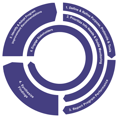
8.1. Monitoring
No one designs a perfect crediting strategy in the first years of operation, and very few have designed robust mechanisms for adaptive management and monitoring of projects (Selman et. al., 2009). For the most part, crediting strategies are new in concept and represent a small fraction of the total conservation or development activity in a region. As such, monitoring and a well-defined adaptive management program can go a long way toward continual improvement in a crediting strategy as well as mitigating risk associated with a new approach.
To be effective, a crediting strategy requires a process for collecting, evaluating and integrating verification and site-level monitoring reports into a high-level analysis that is ideally linked to monitoring at the watershed level. There also needs to be a mechanism for incorporating new quantification methods as they are developed over time.
Adaptive management can help a strategy respond to lessons learned and feedback generated by market activity and new science. It should take place on a predictable schedule using a transparent process to update credit calculation methodologies and revise market rules. As elements of the strategy are revised, existing credit contracts must be honored so that participants have certainty that meeting pre-established performance standards will continue to keep them in good standing.
Adaptive management cycles that are transparent and fixed for a specific period of time provide flexibility to allow for learning as well as predictability, allowing for significant investments with a higher degree of certainty regarding return on investment. As examples, the Lake Tahoe Lake Clarity Trading Program for water quality and the Klamath Tracking and Accounting Program both use a standard adaptive management framework to improve their programs (see Figure 8.1).
Milestone – Ongoing Adaptive Management
The process of adaptive management includes the following:
- Annual report: creating an annual strategy report;
- Periodically assess quantification: determine whether changes are required for quantification systems;
- Research and reporting: creating lists of needed information and reports; and
- Ongoing Improvement: continue to implement strategy improvements over time.
↑ Return to Table of Contents, Appendix B
↑ Return to Table of Contents, Report
IX. Conclusions
Building and operating an ecosystem crediting strategy is not simple, but it is doable. The elements described in this document are intended to help new crediting strategies build on past efforts and get a head start toward success.
While the process involves some significant challenges, the potential benefits in terms of predictability, certainty, consistency, and transparency can be impressive. A more integrated approach to tracking and communicating these outcomes across agencies, actions, ecosystems, and resources holds significant promise for a better and more effective approach to planning, implementing, and accounting for conservation and development actions.
Table 9.1 To build, or not to build, a crediting strategy?
| Advantages of a crediting strategy |
Challenges of a crediting strategy |
| More predictable timing to plan and implement transportation projects |
Often involves multiple stakeholders, which can make agreement challenging |
| Greater certainty that environmental goals are being met |
More programmatic approaches can involve more “what if” scenarios that can take resources to address |
| A consistent way to track for cumulative benefits and impacts tied to conservation and development actions |
A crediting strategy may not generate savings for impacts to resource types that occur only once or twice |
| Provides a common platform for multiple partners to implement mitigation priorities |
Organizing multiple partners can be complex |
| Can make it easier to incorporate the best available science and efficient technology adaptively over time |
Every project is somewhat unique, making it difficult to implement a programmatic approach |
↑ Return to Table of Contents, Appendix B
↑ Return to Table of Contents, Report
X. References
Carpenter, S.L., and Kennedy, W.J.D. (2001). Managing Public Disputes: A Practical Guide for Government, Business, and Citizens’ Groups. San Francisco: Jossey-Bass.
Cohen, J. (1997). “Procedure and Substance in Deliberative Democracy.” In J. Bohman and W. Rehg (Eds.), Deliberative Democracy: Essays on Reason and Politics. (pp. 405 – 437). Cambridge, MA: MIT Press.
Dukes, E.F., and Firehock, K. (2001). Collaboration: A guide for environmental advocates. Charlottesville, VA: University of Virginia. https://intersector.com/resource/collaboration-guide-environmental-advocates/
Emerson, K., Nabatchi, T., O’Leary, R., and Stephens, J. (2003). “The Challenges of Environmental Conflict Resolution.” R. O’Leary and L.B. Bingham (Eds.), The Promise and Performance of Environmental Conflict Resolution. Washington, DC: Resources for the Future.
Fisher, R., and Ury, W. (1983). Getting to Yes: Negotiating Agreement without Giving in. London: Penguin Books.
Gray, B. (1989). Collaborating: Finding common ground for multiparty problems. San Francisco, CA: Jossey-Bass.
Hosterman, H. (2009). Practitioner’s Working Group: White Paper 2. Hillsboro, OR: Willamette Partnership.
Innes, J.E. (2004). Consensus Building: Clarification for the Critics. Planning Theory, 3, 5-20.
Kagan, J.S., R. Fiegener, S. Howie, and M. Venner. 2014. Framework 2: Creating Transportation Focused Ecosystem Crediting Frameworks in States with Active Ongoing Crediting or Mitigation Trading Programs or State Watershed Restoration Programs. ICF Incorporated, LCC, Fairfax, VA. 23 pp.
O’Leary, R., and Bingham, L.B. (Eds). (2003). The Promise and Performance of Environmental Conflict Resolution. Washington, DC: Resources for the Future.
Ozawa, C.P. (1991). Recasting Science: Consensual Procedures in Public Policy Making. Boulder, CO: Westview.
Selman, M., Branosky, E., and Jones, C. (2009). Water Quality Trading Programs: An International Overview. World Resources Institute. Washington, D.C.
Susskind, L., and Cruikshank, J. (1987). Breaking the Impasse: Consensual Approaches to Resolving Public Disputes. Basic Books, Inc.
U.S. Environmental Protection Agency. (2007). Water Quality Trading Toolkit for Permit Writers (EPA 833-R-07-004). Washington, DC: https://www.epa.gov/npdes/water-quality-trading-toolkit-permit-writers.
U.S. Environmental Protection Agency /U.S. Army Corps of Engineers. (2008). Compensatory Mitigation for Losses of Aquatic Resources: Final Rule. Federal Register 73(70) 2008. Washington, DC: https://www.epa.gov/cwa-404/background-about-compensatory-mitigation-requirements-under-cwa-section-404
Willamette Partnership. (2011). Measuring Up: Synchronizing Biodiversity Measurement Systems for Markets and Other Incentive Programs. Willamette Partnership. https://willamettepartnership.org/biodiversity-measurement-for-markets-incentive-programs/
Womble, P. and M. Doyle. 2012. The Geography of Trading Ecosystem Services: A Case Study of Wetland and Stream Compensatory Mitigation Markets. Harvard Environmental Law Review. Vol. 36, pp. 230-296.
Wondolleck, J.M., and Yaffee, S.L. (2000). Making Collaboration Work: Lessons from Innovation in Natural Resource Management. Washington, DC: Island Press.
Yankelovich, D. (1999). The Magic of Dialogue: Transforming Conflict into Cooperation. Simon and Schuster.
↑ Return to Table of Contents, Appendix B
↑ Return to Table of Contents, Report
XI. Example Eligibility Checklist
Ecosystem Credit Accounting System
Version 1.1
Last updated May 1, 2013
Date submitted:
Project Information
- Project Name: _______________________________
Service Area Name
- Service Area Type (e.g., USGS HUC4, TNC Ecoregion): _______________________________
Project Location
- Latitude/longitude: _______________________________
- Estimated Area (acres/hectares): _______________________________
- Estimated Linear Feet of Stream: _______________________________
Project Developer
- Organization: _______________________________
- Contact person: _______________________________
- Title: _______________________________
- Phone/Email: _______________________________
How to use this checklist
Credit Validation is an initial screen of a project’s eligibility to generate credits in the Ecosystem Credit Accounting System (ECAS). The Validation Checklist (Checklist) is meant to be completed early in the project development process so that the Willamette Partnership can give a preliminary determination of eligibility before significant project investments are made.
This Checklist should be filled out by the Project Developer or a party acting on their behalf that is highly familiar with the proposed project. Questions in the Checklist are designed to determine whether the project will meet ECAS eligibility requirements, as described in the relevant General Crediting Protocol (GCP) (noted in 1a). Please use the space provided to describe any circumstances that affect the answer. Complete and correct information is required for the Willamette Partnership to accurately evaluate project eligibility. Please note that this document will be made public for projects that are successfully verified and registered.
The Willamette Partnership’s review and validation of the project at this stage is only a preliminary determination of the project’s eligibility to generate credits. The type, quantity, and final approval of credits are confirmed in later phases. Contact the Willamette Partnership (info@willamettepartnership.org) for assistance with the Checklist.
Eligibility Checklist
1. Credit Types
Indicate all credit types that the Project Developer seeks to generate, the validation lead entity for each credit type, and whether that credit will be compliance-grade or voluntary. For more detail on generating credits, please reference the GCP version noted in 1a.
- Which protocol and version will be used to generate credits?
Enter current protocol name and version unless an earlier version should apply (e.g. General Crediting Protocol version 1.1)
| Credit Categories |
Credit Types
(check all that apply) |
Quantification Method
and Version |
Validation Lead |
Compliance
Grade |
Voluntary |
| Aquatic Habitat |
 Salmon habitat Salmon habitat |
|
|
|
|
| Wetland habitat |
|
|
|
|
| Upland Habitat |
Oak woodland habitat |
|
|
|
|
| Upland prairie/Fender’s blue butterfly habitat |
|
|
|
|
| Water Quality |
Water temperature |
|
|
|
|
| Nitrogen |
|
|
|
|
| Phosphorus |
|
|
|
|
| Other |
Other 1: _______________ |
|
|
|
|
| Other 2: _______________ |
|
|
|
|
Project Description and Timeline
- Provide a brief summary (approx. 50 – 200 words) that Willamette Partnership can use (if needed) to describe the project:
Including but not limited to project location, credit type(s) being sought, anticipated credit-generating activities, pre-project and anticipated post-project conditions, timeline for project implementation.
1. ____________________________________________________________
2. ____________________________________________________________
3. Types of project activities that will be used to generate credits (check all that apply)
| Credit Categories |
Credit Types
(check all that apply) |
Credit Generating Project Activities
(check all that will generate credits) |
| Aquatic Habitat |
Salmon habitat |
- Plant native vegetation
- Restore and create wetland hydrology
- Restore channel geomorphology
- Fish passage barrier removal
- In-stream: Large wood placement
- Protect existing habitat
- Improve function of an existing habitat
- Restore habitat functions
- Other: _______________
|
| Wetland habitat |
- Protect existing habitat
- Improve function of an existing habitat
- Restore habitat functions
- Other: _______________
|
| Upland Habitat |
Oak woodland habitat |
- Protect existing habitat
- Improve function of an existing habitat
- Restore habitat functions
- Other: _______________
|
| Upland prairie/Fender’s blue butterfly habitat |
- Protect existing habitat
- Improve function of an existing habitat
- Restore habitat functions
- Other: _______________
|
| Water Quality |
Water temperature |
- Active riparian restoration
- Other: _______________
|
| Nitrogen |
- Fencing/animal exclusion
- Cover crop
- Crop rotation
- Conservation tillage
- Nutrient management
- Filter strips
- Other: _______________
|
| Phosphorus |
- Fencing/animal exclusion
- Cover crop
- Crop rotation
- Conservation tillage
- Nutrient management
- Filter strips
- Other: _______________
|
| Other |
_______________ |
|
4. Ownership
- Have you reviewed and confirmed ownership of the property where the project will take place? YES NO
Check all that have been reviewed:
- Copy of property deed
- Review of county assessor records
- Title search
- Other:
- Did the property review identify any ownership disputes, conflicting uses, liens, easements, or other items that would potentially disqualify the project from generating credits?
YES NO
If “yes,” please provide separate documentation describing the items and whether they can be resolved prior to project implementation.
- How will ownership of the credits generated from this project be documented between the property owner(s) and Project Developer?
Check the applicable form of document:
- Property lease, recorded with the county
- Property lease, unrecorded
- Access agreement
- Easement, permanent
- Easement, term of years
- Other:
- Has the property been sold or ownership transferred within the last 10 years? YES NO
Describe changes to land ownership in the last 10 years
5. Additionality
- Has the proposed project been reviewed for compliance with all applicable federal, state, and local laws? YES NO
Where existing laws, rules, and regulations are applicable to the project, describe actions taken to comply.
Check all that have been reviewed:
- County ordinances
- Local ordinances (City/Unincorporated areas)
- State law (e.g., Oregon Forest Practices Act); list: _______________
- State guidance; list: _______________
- Federal law; list: _______________
- Federal guidance; list: _______________
Water quality:
- TMDL
- Oregon Agricultural WQMP
- State water quality rules
- Other: _______________
- Does the scope of the credit-generating activities on the property meet and exceed any requirements under Section 5(a) or other standard practices (i.e., “business as usual”) given the applicable land use type, entity, or industry on site? YES NO
As necessary, describe how the project activities exceed standard practice for landuse and management on the project site.
- Were public dollars dedicated to conservation2 used to fund any portion of the credit-generating activity? YES NO
If “yes,” please list the name of the funder, amount (if known), term of the agreement, and use of the funds (particularly any uses that would otherwise qualify as a credit-generating BMP).
- Have previous conservation actions or restoration activities been attempted on the site within the last 10 years? YES NO
If “yes,” please list the name of the funder, term of the agreement, use of the funds, expected outcome, and current condition of the project activities. If previous activities were unsuccessful, please provide a) justification that the activities qualify as having failed; b) relevant factors for failiure; and c) measures that will be taken to avoid similar challenges during the current project.
- Have the agreement(s) and on-site activities expired or been terminated? YES NO
- Are there ongoing obligations under the agreement(s) that require an entity to perform, maintain, or monitor the same types of project activities checked in Section 3? (If “yes,” please contact the Willamette Partnership before completing the rest of this form, as your proposed project may not be additional.) YES NO
- Have any credits been previously generated or sold on the property? YES NO
Describe any previous credits generated on the site and how those actions and areas relate to the current project activities.
- To the best of your knowledge, have any significant portions of the site’s natural land cover been converted or undergone significant ecological change (e.g., wetlands fill, vegetation removal) in the last 10 years? If “yes,” describe the activities and the federal, state, or local environmental or development permit procured. YES NO
Describe significant changes to natural land cover or ecological condition in the last 10 years.
Describe any permits required for actions including, but not limited to development, enhancement, or land use change.
6. Stewardship
- Will the agreement listed in Section 4(c) prohibit incompatible property uses for the life of the credit? YES NO
- If your answer is “no” to Section 6(a), how will incompatible property uses that may impact credits be restricted? YES NO
Notes/Comments as necessary
7. Project Suitability
- Does the project manager have past experience with this type of restoration? YES NO
Notes/Comments as necessary
- Will the project design meet all applicable ECAS minimum quality standards? YES NO
Describe components of the project concept relevant to meeting minimum quality standards and project performance standards.
8. Documentation
- Does the project require agency pre-approvals (e.g., county or city development permit, ODFW review of restoration plan)? If so, describe the necessary permits and/or approvals needed to complete the project. YES NO
Notes/Comments as necessary
- If so, have agency pre-approvals been secured? YES NO
Notes/Comments as necessary
Please attach documentation to support the Checklist. Required and optional documents are listed below. (Note: documents that are optional for Validation may be required for Verification.) Descriptions of these document types can be found at the end of the checklist, see the Willamette Partnership website for links to available document templates (https://willamettepartnership.org/resources/ecas/). Where final or signed versions of documentation are not available, please include labeled drafts. Final versions will be required and reviewed during Verification. Unless required by law or regulatory requirements, documents submitted during Validation will not be shared or made publicly available without consent from the Project Developer.
[Sample] Attestation:
I attest that this information is true to the best of my ability and is consistent with Ecosystem Credit Accounting System’s General Crediting Protocol Version Willamette Basin and Verification Protocol Version Willamette Basin for the Willamette Basin basin.
_____________________________________________________________
[Signature Line]
_____________________________________________________________
[Printed Name]
_____________________________________________________________
[Project Developer, if different from printed name]
_____________________________________________________________
[Date]
* In most cases, draft documents are acceptable at Validation. Full proof of ownership and rights to credits will be required and reviewed at verification.
** It is understood that during the implementation phase, project specifics are likely to change and new information will become available. Upon seeking verification, as-built conditions should be provided in the As-Built Project Design Document.
↑ Return to Table of Contents, Appendix B
↑ Return to Table of Contents, Report
| Document Type |
Description |
| Proof of Ownership |
Confirmation of the legal ownership of the property on which project activities will take place. |
| Project Map |
Delineates the project site, indicating where project activities and any relevant geographic context. For users of Version 2.0, additional information is available in the Protocol Appendix for the relevant credit type. |
| Project Design |
Describes the intended project activities, considerations, and timelines, demonstrates that minimum quality standards will be met. |
| Proof of Rights to Credits |
Document confirming the Project Developer has legal title to the credits to be issued for the project. This could include an easement, legal agreement, legal opinion, deed restriction, letter of intent, contract or other form clearly stating who owns the underlying land and who has rights to own and sell credits generated from the project. |
| Project Protection Documents |
Confirms that the project site will be legally protected from development actions and alterations impacting the performance of credits for the life of the credit. Project Protection Agreements may be the same as Proof of Rights to Credits. |
| Accounting Area Map |
Delineates subareas for which accounting of credits will be linked (accounting units). Accounting units cannot overlap. |
| Service Area Map |
Delineates area within which the credits will be tracked, or, from compliance credits, the area in which they can be sold. |
| Wetland delineations |
Establishes the location and size of a wetland for the purposes of federal, state and local regulations. |
| Monitoring Plan |
Describes how monitoring will be conducted over the life of the credit to ensure project success and the attainment of project performance standards in the ECAS. The Stewardship and Monitoring Plans may be combined. |
| Stewardship Plan |
Describes the Project Developer’s intent for project maintenance including the designation of stewardship responsibility, cost estimates, anticipated activities, and management of stewardship funds. The Stewardship and Monitoring Plans may be combined. Stewardship will also include proof of financial assurances, such as performance bonds, if required as part of a crediting strategy. |
| Agency Pre-Approvals |
Where applicable, confirmation of agency approval to proceed. This may be an approved prospectus, bank, letter or other form. |
| Bank Prospectus |
Where necessary, detailed description of proposed mitigation bank that has undergone review and comment from the Interagency Review Team to assess technical feasibility of the bank development and operations. |
| Bank Agreement |
Where necessary, the formal agreement between the Project Developers and agencies establishing liability, performance standards, management and monitoring requirements, and the terms of bank credit approval. |
↑ Return to Table of Contents, Appendix B
↑ Return to Table of Contents, Report
Appendix C: Crediting and Valuation for DOTs with Complex Conditions
Framework 2
State Departments of Transportation (DOT) have been grappling with ways to develop credits and equivalent actions taken that impact or benefit ecosystems. This report describes approaches that California has experimented with. It also describes an approach that could be useful for DOTs with similarly complex ecosystem and regulatory contexts for project delivery.
Contents
1 Summary
Ecosystem valuation and crediting are effective ways to meet requirements for decision-making that supports sustainable transportation. Valuation and crediting is something that can be applied to ecosystem, transportation, economic, and social conditions and goals. Sustainable transportation is most readily achieved if these conditions are dealt with jointly, rather than piece meal, or as if they were not all part of the decision-space. Ecosystem valuation is a process where equivalent financial or non-financial values are calculated for attributes, features, or processes in natural ecosystems, based on social and other goals for these ecosystems.
The first step is to describe the amount of the ecosystem attribute or process in the decision space (e.g., a corridor plan). The second step is to describe goals/thresholds/values for the attributes or processes. The third step is to develop goals and objectives for transportation and other aspects of a decision space. And the fourth step is to normalize the values among the variable elements in the decision-space. This means that transportation concerns, such as mobility, can be compared to ecosystem concerns more readily. An optional, but common fifth step is to determine ranges of equivalent financial values for ecosystem attributes and processes, as well as for other elements in the decision-space. This allows calculation of costs associated with different actions.
We use California as the primary example in this exercise, because California has been experimenting with different ways to bring ecosystem values earlier in decision-making. This has taken two main forms. One is agreements between resource agencies and Caltrans about how to develop equivalent financial and other values for advance mitigation for projects: the Regional Advance Mitigation Program (RAMP) and the Statewide Advance Mitigation Initiative (SAMI). The other is investigation of valuation theories and methods that could be used in the complex decision environments that surround many plans and projects delivered in California. These approaches are compatible to some degree and in combination inform the series of steps presented here.
↑ Return to Table of Contents, Appendix C
↑ Return to Table of Contents, Report
2 What Is an Ecosystem Crediting Strategy? And Why Build One?
Ecosystem crediting involves several critical steps. The first is understanding what it is for, the second is figuring out who is involved, the third is describing how credits will be established, and the fourth is learning from implementation of the crediting system. The term valuation is often used to describe the process of ascribing value to natural and human components of a system, which underlies developing credits for impacting, protecting, or restoring/improving these components. Just as valuing consumer products is somewhat subjective, valuing ecosystem attributes is also somewhat subjective. For example, the Endangered Species Act theoretically protects all species equally, whereas in reality certain taxonomic groups (e.g., salmon and bald eagles) may receive greater political and financial investments than others because they are more highly valued by society for economic or aesthetic reasons. Although it is challenging to see how valuation could be used to inform infrastructural development decisions, almost all of these decisions happen because of expressed or hidden values, so this informing is already happening. Credits are one way to make valuation more concrete and visible in transportation planning, programming, construction, mitigation, and monitoring.
Ecosystem credits arise from valuing natural attributes (e.g., habitat types), patterns (e.g., distribution of habitat elements), and processes (e.g., nutrient cycling). Credits can be defined as the exchange currency for benefits and dis-benefits when developing, mitigating (avoid, minimize, compensate), or restoring habitat. For example, if a highway department wants to evaluate a change to an alignment to provide more capacity, it could choose a path that minimizes loss and fragmentation of habitat. This choice could affect practicability of the alignment relative to other choices, but would also result in credits for “doing the right thing” which can be quantified as the avoided net loss of habitat value or area. Although these credits should not be transferable to other projects, they are one way for the agency to describe to stakeholders and decision-makers how it is trying to minimize its footprint. The remaining credit loss or impact of the alignment could be mitigated through compensatory mitigation. Because the habitat loss and fragmentation will have been quantified, the equivalent value in this example could be expressed in area of habitat loss, or impacts to species movement.
Strategic use of valuation and credits for ecosystem impacts can help in discussions both within transportation agencies (among divisions and disciplines) and between transportation agencies, regulatory agencies, and third party stakeholders interested in ecosystem protection and restoration. Involvement of these entities early in planning and during design, permitting and programming can help everyone get on the same page as to what is being impacted, what can be done to minimize or avoid impacts, and what can be done to try to compensate for the impacts. Quantifying impacts as credits means that people can start talking in a similar language and understand benefits, dis-benefits, and trade-offs.
The sections below describe valuation in more detail and how standard valuation methods tie to environmental analysis requirements that state Departments of Transportation must meet while developing plans and projects.
2.1 Economic Valuation of Environmental Attributes
Many decisions related to transportation infrastructure are based on economic considerations. Valuation is a useful method to apply to transportation decision-making that must meet multiple needs. For example, valuation helps inform decisions related to regional planning networks (spatially connected elements) and temporally connected sequences of projects that are efficient relative to goals (e.g., have high total benefits). The valuation method also allows for comparisons among project or route alternatives to minimize impacts and maximize total benefits. Also valuation information facilitates the development of mitigation alternatives (avoid, minimize or compensate) and cost estimates. Finally, valuation results may be integrated into a Regional Transportation Plan (RTP) analysis that sets a policy framework for corridor and project-level decision-making.
Economic worth is one way to characterize value. Economic values are based on people’s preferences and choices, as well as market conditions for goods and services with marketable value. Various methods have been developed to value changes in environmental assets. Revealed preference methods are based on the observed behaviors of individuals, i.e., the financial choices individuals make. Examples of revealed preference methods include hedonics, recreation demand, averting behavior models and market price methods. Stated preference methods are based on surveys where people are asked about the value they place on goods, services and amenities in hypothetical situations. The two main groups of stated preference methods are contingent valuation approaches and conjoint analysis (also referred to as choice modeling). Both of these techniques involve construction of a simulated market or simulated reference points. If time and budget constrain carrying out an original valuation study, the benefit transfer method is often used. The benefit transfer method involves using previously-estimated values of environmental attributes in a new study. Examples of valuation and guidance for the appropriate use of environmental impacts analysis and valuation can be found in Bateman et al. (2002); Champ et al. (2003); the U.S. Environmental Protection Agency (EPA) (2000); EPA Science Advisory Board (EPA SAB) (2009); Freeman III (1993); and the National Research Council (NRC) (2005).
2.2 Framework to Valuate Environmental Attributes
International organizations and government agencies provide guidelines and frameworks about incorporating environmental values in the decision-making process, for example: EPA (2000), Asian Development Bank (ADB) (1996), United Nations Environment Programme (1995), and Organization for Economic Co-operation and Development (OECD) (1989, 1994, 1995). More recently, various academic and other organizations have developed and tested methods for valuing and providing credit for environmental improvements useful in conservation and mitigation planning and implementation. Much of this work has been in relation to carbon crediting systems, which may be one of the most extensive and well-investigated. For example, Pichancourt et al. (2014) developed and tested a model for optimizing the carbon stocking and biodiversity richness in forests across a range of climate types. Because plant functional diversity does not always correlate with total carbon stock, an optimum condition may exist that provides the best combined condition for both and thus for earning carbon credits and biodiversity credits in a given forest. This is similar to the transportation planning problem of finding the optimal combination of transportation and ecosystem services.
Based on this existing guidance, a framework that can be used to support a valuation approach for environmental conditions in the transportation planning process is proposed. The framework contains a flow for the valuation process and basic steps for estimating valuations of environmental attributes. Similar to most human activities, infrastructure development, operation and maintenance activities affect the environment to different degrees and at different spatial and temporal scales. The focus of the framework is how to account for the environmental impacts and their economic value early in the planning process. Valuation of environmental impacts generally involves the following steps:
- identifying potential impacts;
- screening and categorizing the impacts;
- quantifying the impacts; and
- valuate the impacts.
These values are then turned into credits associated with benefits and dis-benefits (impacts) and incorporated into the overall project (plan or program) analysis.
2.3 Federal Guidance
The Safe, Accountable, Flexible, Efficient Transportation Equity Act: A Legacy for Users (SAFETEA-LU) of 2005 placed more emphasis on consideration of environmental issues and avoidance of impacts early in the transportation planning and decision-making process. Specifically, Section 6001 contained provisions mandating two aspects of the development of long-range transportation plans, one of the earliest stages of the process. First, plans must include a discussion of environmental mitigation activities (including avoidance, minimization, and compensation for impacts). Also, agencies must hold consultations with state, tribal, and local agencies for land use management, natural resources, environmental protection, conservation and historic preservation. Section 6002 established mechanisms for increasing efficiency in the environmental review process. It requires that participating agencies and the public be involved early in the review process. The formal consultation requirements established in these provisions facilitate the incorporation of the results of transportation planning into the National Environmental Policy Act (NEPA) environmental review process (U.S. Congress, 2007). Early participation in transportation planning provides environmental, regulatory and resource agencies better insight into the needs and objectives of the transportation plan. It also provides an important opportunity for environmental, regulatory, and resource agency concerns, such as those related to permit applications, to be addressed early in the process (U.S. Congress, 2007).
Although the statutes call for the consideration of environmental impacts and mitigation needs early in the transportation planning process, they did not define how planners can effectively engage in early environmental evaluation. The challenge of evaluating environmental impacts is partly because environmental attributes and processes tend to be “non-market goods,” in that they are not bought or sold directly in the market and do not have observable monetary values. In order to consider both environmental and economic benefits and costs at the same decision point, it is important to put them on the same scale to ease comparisons. One way to do this is to convert changes in environmental conditions and processes to monetary values. Fiscal valuation of environmental attributes is often used in cost-benefit analysis (CBA). Although CBA has been used extensively in the U.S. as a project evaluation method, most transportation investment projects do not explicitly estimate the valuations for environmental attributes, even though the impacts on human well-being, and therefore implicit monetary value, may be quite large. Fiscal valuation also is fraught with the uncertainties and variation associated with coming up with monetary equivalents for things as varied as air quality impacts, wetland protection, wildlife movement, and traffic noise and light effects. Because quantification of impacts is required before calculating fiscal equivalencies, we recommend converting impacts to a non-fiscal value equivalent, which can then compared to similarly-converted benefits valuation.
↑ Return to Table of Contents, Appendix C
↑ Return to Table of Contents, Report
3 Crediting and Valuation in California
State agencies in California have relied on two primary projects to define crediting and valuation for use in planning:
- the Regional Advance Mitigation Planning (RAMP) and the State Advanced Mitigation Initiative (SAMI); and
- Caltrans’ valuation approach.
3.1 SAMI
SAMI is a program of Caltrans to experiment with planning and carrying out mitigation in advance of project construction. The planning and assessment phase of advanced mitigation is typically considered to be a regional activity, but coordinated at the state scale, potentially through agreements with state and federal wildlife agencies. In 2011, Caltrans signed a memorandum of understanding (MOU) regarding SAMI with California Department of Fish and Game (now Fish and Wildlife), US Army Corps of Engineers, the US Environmental Protection Agency, the US Fish and Wildlife Service, and the National Marine Fisheries Service (Caltrans, 2011). The MOU states that the purpose of the agreement is to establish “a mutual framework for coordinated review concerning development of an Initiative in California by Caltrans and California Department of Fish and Wildlife for advance mitigation and conservation planning for planned transportation projects at a landscape scale.” The Initiative is designed to support collaborative conservation and compensatory mitigation planning to “simplify and clarify the process for Caltrans, save agency staff time, reduce the cost of evaluating a mitigation/conservation proposal, and simplify oversight….”
Although the initiative is described as “mitigation” (which usually is defined as avoidance, minimization, and/or compensation) it primarily targets off-site, compensatory mitigation as a method of conservation. The preferred “mitigation/conservation methods” are currently undefined and will be developed and approved by the MOU signatories. The discretionary use of the MOU, or other agreements by the participating agencies, is intended to keep the process voluntary. However, the lack of developed methods challenges its utility.
Further, despite the involvement of permitting agencies and the University of California in the development of this initiative, several areas of risk remain:
- While predictability will increase, there is no evidence that costs to Caltrans will be reduced and if they are, which aspect of costs will be impacted. For example, reduction in costs for conservation could reduce conservation effectiveness.
- In spite of involvement of landscape ecologists at the University of California in the Initiative, there is no evidence that coordinated offset mitigation at the landscape scale actually results in greater conservation outcomes. Although the idea makes sense and has received support among conservation planners and scientists, it is experimental and failure of the approach at the proposed scales could result in significant liability to responsible parties and potentially greater rates of species listing and endangerment.
- The MOU states clearly that the terms of the agreement do not abrogate the agencies of further responsibility under applicable laws. This means that even if agreements between Caltrans and permitting agencies are signed under the aegis of the MOU, or in general, there is no guarantee that further conservation actions will not be required when projects are built. While this provision enables many agencies to sign the agreement whereas they would not otherwise be able to do so, the agreement is essentially an understanding among willing individuals. Legally, the provision could be invoked and subsequently reduce many of the benefits (assurances, reduced costs) of the approach.
Despite the drawbacks of the approach as developed, there are positive elements about SAMI that could be used to inform valuation and crediting strategies for sustainable transportation planning. Early discussions between Caltrans and environmental permitting agencies mean that problems can be averted before they arise. This can occur at the region, corridor, or project scale. Assessing regional ecological conditions in advance of transportation planning is always wise, because it helps to avoid and minimize impacts to natural systems, as well as accounting for what may be impacted. Finally, negative publicity and litigation are less likely to arise if Caltrans can demonstrate that they investigated the ecological settings around target highways and understand and can mitigate impacts.
3.2 RAMP
The Regional Advance Mitigation Planning program (hereafter RAMP) is an inter-agency plan and agreement about mitigation of environmental harm from infrastructural development (Caltrans, 2011; California Department of Water Resources, 2012). Although the title of RAMP implies that it deals with all mitigation (avoidance, minimization, and compensation), it is limited to compensatory mitigation. RAMP is intended to be consistent with the Environmental Stewardship Policy of the California Department of Water Resources, promulgated in 2010, which is intended to improve consideration of environmental benefits as an important outcome of project development. RAMP is also intended to support Caltrans’ use of Eco-Logical, which the agency understands as integrating “ecological benefits into project planning as early as possible.”
One problem with RAMP is that it inappropriately merges the conservation of habitats and species, with compensatory mitigation. There is little evidence in the scientific literature that this is possible and results in ecological benefits, even for regulated species and habitats. While the goal of RAMP was to use regulatory mitigation funds in the most efficient way to achieve conservation objectives, past research from a similar program in North Carolina (BenDor 2009), indicates that the desired results have not been forthcoming. RAMP also assumes that by combining mitigation actions in space and time into a few large, early actions, better conservation outcomes will result. This idea has not been generally tested. In practice, mitigation banks area often not very successful at achieving meaningful conservation, possibly because they are often not located in areas that have been identified in regional conservation strategies. Finally, one inducement that is used to get infrastructure agency participation is the idea that early mitigation actions will not need to be modified by the time the impact (built-project) occurs, which at this point has not been proven to be true.
On the positive side, the program does encourage consideration of impacts across appropriately large areas and inclusion of regulators and infrastructure agencies early in planning. Environmental conditions and transportation projects would be mapped at regional assessment scales. This would theoretically lead to estimation of impacts and location of mitigation actions within the assessment region. The program would have a finance plan, steering and regional advisory committees, and a program manager.
In conclusion, RAMP and SAMI contain good examples of procedures that infrastructure agencies could use to plan ahead for environmental impacts and mitigation, but how this is done matters. By transparently accounting for all impacts and benefits of transportation system plans and projects and by providing a mechanism for comparing the impacts and benefits (credits), agencies can articulate why particular decisions were made, why the costs associated with design and alignment are necessary, and provide a framework for evaluating the results of decisions to inform later decision-making. Valuation and crediting are the best way to formalize and describe how impacts and benefits can be compared and why particular build and mitigation actions were taken.
3.3 Caltrans Valuation Approach
In response to an increasing realization that it would be helpful to consider environmental conditions in the same decision space as economic and cost considerations, Caltrans collaborated with UC Davis scientists to develop the approach: “Economic Valuation of Environmental Conditions and Attributes” (http://ice.ucdavis.edu/project/economic_valuation_environmental_conditions; Lee et al., 2010). The approach was based on two primary principles:
- that valuation is founded on attachment of social and regulatory value to quantifiable environmental and transportation conditions and attributes, and
- that there is a variety of tools to attach fiscal equivalents to environmental attributes.
Although the approach could be used to inform development of RAMP and SAMI, the primary difference between this approach and these other programs is that the approach was developed to inform transportation planning in general, not just mitigation planning. The primary thesis of the approach was that incorporation of environmental information early in planning would improve ecological outcomes and that one way to do this was to transform environmental and other information into a common economic “language.”
The basis for this common language is in normalization of raw parameters (e.g., number of affected animals; vehicle-miles traveled) in a decision-space to a common scale. In this case, scale is not referring to geographic extent (e.g., region) or resolution; examples of common scales are equivalent geographic size (acres), or monetary equivalents. This requires understanding the end-points and governing rules for the scale. The end-points are most simply defined as undesirable conditions and desirable conditions. For example, a common un-desirable condition is declines in endangered species or their habitat while, the desirable condition would be recovery of the same endangered species. The governing rules for the normalization scale include:
- establishing the nature of the relationship between the parameter value (e.g., acres of some habitat type) and its normalized value, which could be step-wise or continuous, and
- establishing the function that allows conversion of the native parameter value and the normalized value, which could be a “credit” (e.g., a linear 1:1 relationship).
There are many considerations that come into play in defining the end-points of the normalization scale and the function that allows conversion of parameter values to normalized value. This approach has been used in a wide range of projects in California, including most recently the California Water Plan Update 2013 and the California Forest and Rangelands Assessment 2015 Update.
↑ Return to Table of Contents, Appendix C
↑ Return to Table of Contents, Report
4 Recommended Crediting and Valuation Framework III
The recommended approach to valuation and crediting in Framework III is based on the founding principles that social and regulatory values and thresholds drive which environmental conditions are considered important for decision-making and that credits can be expressed in both fiscal and non-fiscal forms.
Valuation and crediting steps:
- Step 1: Identify the types and degrees (per type) of potential impact;
- Step 2: Calculate the relative value of the harm, compared to reference and other conditions;
- Step 3: Calculate the benefits to the regulated systems from particular design or alignment decisions;
- Step 4: Translate impacts and benefits associated with transportation decisions into a common scale to allow comparison.
4.1 Founding Principles
In order to carry out valuation and crediting for transportation, it is important to first identify why valuation and crediting is important. From a process point of view, one way to identify the reasons for valuation and crediting is to consult with stakeholders to find out what regulated and unregulated conditions are considered to be most important to them in the region or study area. Another way to identify reasons is to examine regulated or potentially regulated environmental attributes or processes. Following identification of valued conditions, it is important to also define the thresholds of concern (e.g., recovery of a listed species, or restoration of a particular habitat). Finally, it is important to quantify the benefits and impacts of proposed actions (projects) and systems of projects (in regional plans). These impacts and benefits can then be translated into credits that can inform decisions about projects and associated mitigation.
4.2 Valuation Approach
The proposed valuation approach in Framework III includes identifying conditions and impacts of concern in the transportation decision-space, quantifying impacts to identified conditions, and estimating equivalent value for the impacts. These impacts are determined by comparing the “with project” and the “without project” impacts related to the baseline information for environmental conditions available in a region or corridor.
After the impacts are identified, impact screening helps to decide how different types of impacts can be evaluated. For example, will the impact be mitigated? Can the impacts be quantified and monetized? Are the impacts relatively small? The EPA SAB (2009, p. 74) suggests that potential impacts can be categorized into the following five categories:
- Category 1: Effects that can be assessed and monetized using available ecological models and appropriate economic valuation methods, including benefits transfer.
- Category 2: Effects that cannot be monetized, but that can be quantified in biophysical terms using available ecological models and for which some indicators of economic benefits exist.
- Category 3: Effects that can be quantified in biophysical terms but for which no indicators of economic benefits exist.
- Category 4: Effects that can be qualitatively described and generally related to benefits based on available ecological and social science, even if they cannot be quantified.
- Category 5: Effects that are likely to generate important non-economic values.
If an impact is to be mitigated (avoided, minimized, or compensated), it should be assessed quantitatively, and the mitigation costs should be included in the regional transportation plan, corridor plan, or project’s overall analysis. It is important to note however, that mitigation costs are not the same as economic values. Mitigation costs may be based on straightforward engineering calculations or actual expenditures. The economic values of changes in environmental attributes are derived from measuring the effects of these changes in human welfare. If an impact is not mitigated, and it can be assessed quantitatively and monetized, economic values of those impacts are incorporated into the overall project (or program) analysis. If an impact cannot be quantified or if an impact is likely to generate important non-economic values, the impact should be describe qualitatively. The Asian Development Bank (ADB) (1996) suggests that if the individual and cumulative impacts are relatively small, they may not warrant further evaluation.
Impact quantification requires data on potential risks, geographical and temporal extents of the impacts and severity. It is important to be able to show a relationship between an impact and a quantifiable well-being or ecological outcome at an appropriate scale. However, a “correspondence problem” can arise if the “object” of preferences does not correspond to the physical measure of the environmental change (Bateman et al., 2002). Bateman et al. (2002) provide an example of this with physical data for water quality to illustrate the correspondence problem with the statement: ‘a reduction of X tons in biochemical oxygen demand (BOD)’ in a river. Individuals do not have measurable preferences for BOD. They have preferences for water quality. Therefore, it is also important to express the physical data in a form that is suitable for monetization in an economic valuation study.
If impacts are measurable, the next step is to value the impacts. A way to think about this is the example of describing the ecological value of an impact to an endangered species. Horne et al. (2011) investigated the habitat value of patches of different sizes and distributions for maintaining Golden-cheeked warblers at Fort Hood, TX. They found that no single set of rules could be developed for patch value and thus no guidance for mitigation for habitat loss for the species could be provided. They cautioned that their “results point out the risk of assigning conservation value by relying on professional judgment or incomplete knowledge to estimate metapopulation parameters or habitat quality.” Estimating the value of environmental changes may depend on incomplete knowledge, which has meant that values often range widely and that conservative approaches that cover a range of conditions may help to reduce conflict.
Valuing impacts can be understood to have economic meaning; and different valuation methods are available to value non-markets goods and services, usually in terms of financial cost. Litman (2009) provides an extensive literature review on the costs of environmental impacts from the transportation sector including air pollution, greenhouse gas emissions, noise, land use, water pollution and waste disposal. However, not all impacts can be evaluated by using economic valuation methods. A review by Delucchi and McCubbin (2010) shows that only congestion delays, accidents, air pollution, climate change and noise impacts have good cost estimates in road transportation.
The next step in the framework is to incorporate the values of the affected environmental processes and attributes, and conduct a qualitative analysis of those non-measurable impacts into the overall transportation plan, project or corridor analysis. There are potential evaluation-scale effects on the process (project, corridor, and region) – it may be desirable to develop different flows of valuation process and decision-process for each scale. Both natural (e.g., watershed, ecosystem) and jurisdictional (e.g., district, county) scales can be used to frame the flow of the valuation process and to determine appropriate scales of analysis.
4.3 Crediting Approach
The proposed crediting approach in Framework III has three sequential components:
- Calculating relative impacts and credits,
- Calculating fiscal equivalents for mitigation actions to reduce or offset impacts, and
- Estimating the relative benefits and dis-benefits (impacts) of different proposed actions.
4.3.1 Using Credits to Calculate and Compare Relative Impacts

Figure 1. Comparison of relative impact to a valued ecological attribute between two theoretical settings alongside a highway.
Impact is an important concept in environmental assessments associated with transportation decision-making. Impact refers to the total change an action (e.g., highway widening) induces in a target process or attribute (e.g., wildlife species population). Relative impact refers to the degree of change within a closed assessment area (e.g., within 1 km of either side of a highway segment). For example, if a project was likely to affect three acres of wetland near the highway (Figure 1), it would matter whether this represented 10% (Figure 1A) or 30% (Figure 1B) of the wetlands within the study area. Although relative impact does not replace total impact as an important concept in environmental analysis, it does help to understand the relative importance of alternative actions within a study area.
In this case, credits could be defined as equivalent to relative (%) impact of alternative actions. This is different from using credits defined as equivalent to impacted area (acres), or degree of impairment within the affected area. So, for this example, alternatives would be considered based on their relative impacts on valued attributes/processes within the assessment area and credits would be based on this relative impact, rather than total impact, which is not a relative concept. One alternative (A) might impact 1% of the wetland area by completely developing it. Another alternative (B) might not directly remove wetland area, but might reduce function of 10% of the wetland area by 50% (e.g., by affecting hydrologic processes). Credits might be determined as: 1 credit = % affected area X degree of impact. So, for A: 1% X 100% = 1 credit and for B: 10% X 50% = 5 credits. In this case, these credits need to be made up by some other action, so represent a “negative-credit.” A related calculation could also be carried out where wetland area (acres) times degree of impact (reduced function) could be used to calculate total impact.
A more real example comes from a study of California tiger salamanders, an endangered species (Searcy, 2011). In this case, the author measured dispersal of salamanders from natal ponds and developed a model for dispersal useful in population dynamics. The model was used to calculate the mitigation needed for a landfill expansion project that would take salamander breeding habitat and compared this to the mitigation required by the US Fish and Wildlife Service (USFWS), which was based on purchase of a parcel of land containing salamander habitat as compensation. Habitat protected through this compensatory mitigation approach was defined as credits and non-compensated loss of habitat was defined as deficits. They found that the functional compensation of new breeding habitat required by the USFWS was 30% of what should have been required biologically, meaning that only 30% of required credits were earned through compensatory land purchase. The lesson here was that credits should be defined by environmental outcomes, not just area of land.
4.3.2 Using Credits to Calculate Fiscal Equivalents for Mitigation
The most common understanding of the term “credit” when applied to development impacts is as an offsetting device for some kind of harm, or input to the environment (e.g., carbon credits). Usually these are developed as devices that can be given a fiscal equivalent, which is true of ecosystem credits in this Framework. The preceding steps to developing a fiscal equivalent for a credit are:
- Understanding the type and quantity of impact,
- Understanding the importance of the impact relative to social and regulatory norms, and
- Describing the thresholds and/or targets which are used to quantify a credit.
One simplistic way that credits are developed is take the quantity of impact and define a credit as the equivalent quantity that must be reduced. For example, if an acre of wetland is developed, then a new acre with identical function must be constructed. This approach only suits compensatory mitigation and cases where there is no questioning of equivalencies among wetland areas and where new wetland construction is possible, and where avoidance and minimization are not needed types of mitigation. For more complex cases where compensatory mitigation is either not possible, or is likely to be challenged in court, credits may need to be developed to rationalize costs associated with lower impact projects.
The road effect zone (REZ; Forman et al., 2003) is a geographic description and quantification of the impacts of roads and highways on the surrounding landscape. The land area affected by specific types of impacts can be quantified and the equivalent values for the impacted environmental conditions calculated. There are several ways to calculate fiscal equivalents described in section 2.1. There are also many fiscal equivalents in the literature, summarized in Appendix B of the Caltrans Valuation Approach. Although these change with time and specific planning area, they provide an idea of the relative fiscal value and range in values that society puts on specific environmental components (e.g., salmon ranges from $28 to $138/salmon-year, 2006 $). Based on the technical and scientific literature, the Victoria Transport Policy Institute (2009) developed a guidebook of costs associated with a wide range of transportation impacts (see Appendix 1 for examples). Most of these are related to things like health impacts from air quality impairment (e.g., CAN$317,000/ton PM2.5), and land-use impacts from vehicles (e.g., $0.067/VMT). Because the actual monetary value can vary considerably among regions and over time, developing equivalent credit values is best done by planning regions and used within fixed time frames for subsequent corridor and project planning.
The value of using credits as exchange units between impact quantification and mitigation cost calculations is primarily because the same unit can be used across many types of units that differ fundamentally in their native units (e.g., tons, hectares, number of individual animals). In each case, the credit can be defined as the contribution of the quantified impact on meeting desired conditions, or degrading conditions away from target or reference conditions. In this way, credits for air quality will mean the same thing as credits for impacts to wildlife. The equivalent monetary value for credits can then be calculated. As transportation projects cause conditions to approach desired or undesired target conditions, the cost of the each unit of change may change non-linearly. By understanding this rate of change, credits can also be developed so that they mean the same thing across a wide range of environmental conditions. For example, the public’s willingness to pay for individual salmon may depend on whether or not the salmon are endangered, in which case the equivalent value may be very high, or a very healthy population, in which case the equivalent cost may be low and roughly the same as the retail value of the fish. The rate of change between these ends of the spectrum is unlikely to change linearly, especially as fish become more endangered. By taking into account the rate of change function in credit development, phenomena like rarity can be controlled for.
4.3.3 Using Credits to Compare Alternatives
Comparing the relative benefits and dis-benefits of different transportation alternatives is part of most decisions about proposing, programming, designing, building, and mitigating most transportation projects. Comparing the benefits/dis-benefits across project domains (e.g., air quality, habitat loss) is not often carried out, though this would no doubt help support most such decisions. Valuation and credits are one method that could be used to formalize comparisons among alternatives, as well as prioritize mitigation actions.
The crediting method described here is presented as an example representing a common type of decision associated with large urban and near-urban projects where highway travel, congestion relief, light rail travel, air quality, habitat impacts, and community impacts are all important domains in decision-making. The method relies on clear statements of goals/policies about travel modes, habitat protection/restoration, air quality improvement, travel time, and transportation system impacts. In the example (Table 1), desired and undesired conditions are expressed as targets against which current or proposed conditions are compared. Credits are calculated based on departure from these desired and undesired targets. No change in condition receives zero credits. Identity to the undesired target = -100 credits. Identity to the desired target = +100 credits. For example, under average annual daily travel (AADT) for Alternative A, the desired target is for a 20,000 AADT reduction for the highway and the undesired target is a 40,000 AADT increase. The predicted volume for this alternative is a 20,000 AADT increase. This is equivalent to -50 credits because a 20,000 increase is half of the undesired target of a 40,000 AADT increase. As a reminder, a 40,000 AADT increase would equal -100 credits. All domains are considered equally important and thus equally weighted. Credits are calculated for each domain within each alternative as well as the total credits for each alternative.
Table 1. Example of using credits to compare among alternatives including structural and modal changes.
| Alternative |
Domain |
Desired Target |
Undesired Target |
Credits |
Total |
| A. Lane addition; 20,000 AADT increase; short term 5% reduction in travel time, then 5% increase; 10% increase in air pollutants; 40 acres (2%) habitat consumption; 1,200 acres impacted area (60%, traffic noise) |
AADT |
20,000 reduction |
40,000 increase |
-50 |
-230 |
| Congestion |
20% reduction travel time |
20% increase travel time |
0 |
| Air quality |
10% reduction |
10% increase |
-100 |
| Habitat |
10% increase |
10% decrease |
-20 |
| Impact area |
0% increase |
100% increase |
-60 |
| B. Light rail system augmentation; 10,000 AADT decrease; long-term 10% reduction in travel time; 5% reduction in air pollutants; zero acres habitat consumption; 400 acres impacted area (20%, LRT noise) |
AADT |
20,000 reduction |
40,000 increase |
+50 |
+130 |
| Congestion |
20% reduction travel time |
20% increase travel time |
+50 |
| Air quality |
10% reduction |
10% increase |
+50 |
| Habitat |
10% increase |
10% decrease |
0 |
| Impact area |
0% increase |
100% increase |
-20 |
| C. No action; 15,000 AADT increase; 15% increase in travel time; 7.5% increase in air pollutants; zero acres habitat consumption; 900 acres impacted area (45%, traffic noise) |
AADT |
20,000 reduction |
40,000 increase |
-38 |
-233 |
| Congestion |
20% reduction travel time |
20% increase travel time |
-75 |
| Air quality |
10% reduction |
10% increase |
-75 |
| Habitat |
10% increase |
10% decrease |
0 |
| Impact area |
0% increase |
100% increase |
-45 |
In this example, alternative A is a typical highway expansion project to increase capacity, alternative B uses light rail improvements to both decreases current trips and to accommodate expected trip increases, and alternative C is a no-build alternative, but recognizes that some changes will continue (e.g., in trip increases). In this example, the build and no-build alternatives have similar credit values, but differ in the number of credits across domains. Assuming that domains were equally weighted and also assuming that costs of each of alternative A and B were similar, comparing total credits would appear to make alternative B the obvious choice.
Although many alternative comparisons generated by transportation agencies (e.g., Caltrans) are limited by number of alternatives, this approach could help expand the discussion about domains within alternatives and potentially result in new alternatives.
Because this approach normalizes conditions within all domains to explicit targets for the domains, the credit values are quantitative representations of conditions within each domain. They therefore have concrete accounting value beyond assisting with comparison among alternatives.
4.4 Decision Boundaries and Spaces
Transportation decisions occur at multiple scales and interface with a variety of stakeholder and regulatory concerns. Specific valuation and crediting actions will vary at these different scales. Regional transportation plans ideally articulate aggregated system-wide changes that will improve traffic flows and meet changing mobility needs. They are often developed by Metropolitan Planning Organizations (MPO) in collaboration among local and state transportation and land-use agencies and usually require mitigation of impacts to natural systems and human communities. Corridor management plans cover highway corridors and spatially function as an intermediary between regional plans and project development. Individual projects are contained within and programmed according to regional or corridor needs.
Developing a tiered approach to plan and implement valuation and crediting is likely to be the most cost-effective approach. In the parallel world of carbon credits, project-by-project assessments of credits means that very few forest land-owners can develop and sell credits. An expert in this field, van Oosterzee (2014) has suggested that using rule-based approaches at regional scales would allow a wider range of individual land-owners to opt-in because they could avoid part of the transaction cost (credit development). The analogy in transportation would be the SAMI and RAMP types of approaches in California, with the addition that region-based rules and crediting schemes, quality control, and performance-monitoring would need to take place to ensure that the desired outcomes are achieved. In this case, state-scale entities would work with regional or district transportation agencies to develop regionally-appropriate valuation and credit systems. Regions and districts would develop plans at the region, corridor, and project level that tiered from this overall framework.
4.4.1 Regional Transportation Plans
Regions are appropriate scales at which to analyze certain impacts from transportation systems (e.g., ecoregional biodiversity and air quality). Through MPOs, regions and regional plans provide institutional frameworks for analysis, decision-making, and programming (Handy, 2010). They are also suitable scales of analysis for almost all surface transportation related impacts and benefits. They are also excellent scales for planning transportation systems as networks of inter-connecting modes and infrastructures.
Currently, the air quality impacts of the RTP are analyzed as a part of the conformity process under federal requirements, but other environmental impacts are not typically analyzed. MPOs can valuate environmental attributes at the early scenario planning stage to guide the selection of the preferred development scenario for the region. In addition, valuation of environmental conditions and impacts could be used in selecting transportation projects to be included in the long-range RTP and in evaluating alternative transportation system plans. Similarly, crediting actions can be accomplished efficiently at the regional scale, by:
- Identifying and quantifying types and degrees of impacts and benefits,
- Defining credits that are equivalent to impacts and benefits, and
- Describing how credit equivalencies could be used to choose among projects and/or inform mitigation planning.
An MPO also develops the Regional Transportation Improvement Program (RTIP) to implement projects and programs listed in the RTP. The RTIP serves as a MPO’s request to the state’s transportation commission for projects to be funded through the state’s transportation funding program. Valuation of environmental conditions and impacts could be considered in the prioritization of projects for the RTIP.
4.4.2 Corridor Management Plans
Transportation agencies, such as California Department of Transportation (Caltrans) Districts, conduct system planning, and establish long-term corridor plans. The corridor scale implicitly includes the project scale and is a sub-unit of the regional and district scales. Planning for the corridor scale may also provide an important vehicle for reducing the harm from these impacts, an opportunity to remediate current harm and mitigate (avoid, minimize) future harm. The corridor scale also provides an opportunity to organize more multi-disciplinary planning that looks at the whole range of mobility improvements, along with long-term operations and maintenance and the environment and human communities.
Valuation and crediting in corridor planning could be tiered from similar processes at the region scale. Specific impacts and benefits at the corridor scale help to make the valuation/crediting at the region scale more concrete. So far, there has been no significant attempt to include environmental effects of transportation planning at the corridor scale in the various corridor level plans. Environmental impacts are generally dealt with at the individual project scale. However, when considered as a whole, a corridor’s use and modification may have important consequences for surrounding natural and human communities. For example, a single interstate corridor may be the primary contributor of fine particles, NOx, polycyclic aromatic hydrocarbons (PAHs), metals, ozone, and other pollutants to surrounding landscapes and neighborhoods. It may also pose the primary barrier to wildlife movement and contributor to wildlife mortality from wildlife-vehicle collision in adjacent natural areas.
Applying the analysis in the proposed framework in the corridor level planning stage can guide the later selection of which strategies will be developed into improvement projects and will be allocated funding in the RTP process. The analysis could lead to selection and prioritization of those strategies (later projects) that avoid or minimize harm to the environment. This is very early in the process and would be most effective in avoiding impacts.
4.4.3 Project Development
At the project initiation phase of the project development stage, many transportation agencies prepare a project study report, which includes a need and purpose statement, project alternatives, environmental determination and environmental issues, and funding and cost estimates. The information in the environmental determination and environmental issues section includes brief descriptions of the known inventory of environmental attributes and environmental issues, identification of existing known hazardous material/waste sites adjacent to the proposed project, and descriptions the anticipated type of environmental documents for compliance with the NEPA and the California Environmental Quality Act (CEQA).
Valuation of environmental attributes could be used at this stage to evaluate the potential environmental impacts associated with each project alternatives, and to better estimate the mitigation costs of environmental impacts. If considerations of environmental attributes were anticipated by conducting valuation in earlier planning phases, this process will be streamlined and projected estimates can be refined. Credits could be calculated for specific impacts and benefits associated with projects, using the rules and guidelines developed at the corridor and region planning scales.
Use of Environmental Valuation at the Programming Stage
At the programming stage, state decision-making entities (such as the state transportation commission) require transportation agencies to provide a quantitative and/or qualitative evaluation of its RTIP or the Interregional Transportation Improvement Program (ITIP), and to comment on each of the performance indicators and performance measures, including the return on investment/lifecycle, before they are submitted to the CTC for incorporation into the State Transportation Improvement Program (STIP) (see CTC 2009). Caltrans uses California Life-Cycle Benefit/Cost Analysis Model (Cal-B/C) to evaluate the return on investment/lifecycle required by the CTC. The benefit categories in the Cal-B/C model includes travel time savings, vehicle operating cost savings, safety benefits (cost savings from avoiding accidents) and emissions reductions. All cost categories include direct project costs, mitigation costs, and transit agency cost savings.
Currently, the Cal-B/C model does not estimate valuations for most of the environmental impacts, and it is not required to do so under the principal environmental and transportation laws, including CEQA, NEPA, and Endangered Species Act (ESA), that govern the required assessments. However, SAFETEA-LU includes several provisions (specifically, Section 6001) intended to enhance the consideration of environmental issues and impacts within the transportation planning process. Incorporating the values of the environmental impacts within Cal-B/C at the time of analysis can better account for the benefits and costs that the society may incur. By doing so, project programming decisions would be based partly on maximizing environmental benefits and accounting for environmental values that are lost and gained among various alternatives, an important advance in sustainable transportation planning.
4.4.4 Geographic Space
Transportation infrastructure decisions impact and involve human community and ecosystem processes and attributes at various scales. At the finest scale, portions of the alignment itself, individual projects may enhance (e.g., expanded aquatic crossing for wildlife and fish) or damage valued ecosystem attributes. Projects at this scale require project initiation documents (PIDs) and some level of environmental analysis. At a coarser grain/larger extent, there may be multiple coordinated projects along a transportation corridor, sometimes described within a multi-year corridor management plan (CMP). At this scale, impacts will occur at the project scale and at a larger extent, well beyond the right-of-way. At the regional scale, regional transportation plans (RTPs) contain many project descriptions, multiple corridors, and extend for several decades. At this scale, impacts occur at finer/smaller scales, as well as at ecosystem, or multiple-ecosystems scale.
The scale of impact from transportation operations and projects has been characterized in the literature as the Road Effect Zone (Forman et al., 2003). This is the area of the landscape where natural (or human community) processes and attributes are affected in some way. Credits are best developed at this scale since this is the scale of impacts.
4.4.5 Stakeholder Concerns
Stakeholders are people who have a stake in the outcome of a process or decision. Who the stakeholders are and their level of organization may vary across the geographic and planning scales. The concerns are also likely to vary according to the type and impact of the project, or group of projects.
Concerns relevant to crediting can be elicited in two ways. One is a scoping exercise, involving stakeholders in identifying the issues and impacts that people and organizations are most concerned about. The second is involving stakeholders in quantifying the impact and developing equivalent values and credits for the impacts. Although individual stakeholders may not be qualified to develop the values and credits used, they are an important source of information about opportunities, constraints, and value systems that come into play in particular regions where decisions about transportation corridors are made.
4.4.6 Regulatory Concerns
Most crediting programs are driven by concerns about particular natural processes, species, or habitat types. In the simplest case, mitigation of harm to regulated habitat is required to be an equivalent area of habitat somewhere off-site. Harm is usually calculated as the infrastructure footprint, plus additional area impacted during construction, or indirectly impacted by the infrastructure. Ecological harm is often discussed, but is usually not calculated or valued based on traffic noise propagation, stormwater runoff, interruption of stream processes, inhibition of wildlife movement, or other known impacts of traffic and highways on ecosystems.
Building a sustainable transportation system requires understanding and planning for the integration of both societal concerns about impacted systems and the modification of transportation decisions to provide for the best ecological outcome. In order to achieve the best outcome, it is necessary to account for the impacts and benefits that can be predicted from “building out” particular plans and decisions. This accounting is best done with a common scale for the disparate types of impacts and benefits. Although the common scale is often monetary, this is not suitable for regulated systems because of the large amount of variation in equivalent monetary values for natural features in the literature that stem from natural variation, dissimilar social values for the same system among regions and populations, and changes in these values and land values with time. This variation will plague any attempts by transportation agencies to ensure that mitigation costs will stay relatively fixed between a plan and project construction. In the case of regulated systems, it is best to make decisions based on credits for impacts and benefits that are based on the relative value of systems that are impacted or receiving benefits. Although these values and credits will have their own uncertainty and variation, it will always be less than the equivalent monetary value because calculating equivalent monetary value introduces a new source of variation and uncertainty.
4.4.7 Knowledge and Capacity
Although the underlying principles of valuing things and giving/selling credit are familiar, the valuation and crediting process in transportation is new for most people. It is unlikely that enough will be known about a particular natural system, or society’s value for the systems, to fully inform crediting. However, the likelihood of making good decisions about the systems and crediting increases the more knowledge is gained and the more knowledgeable people are included.
Many decisions about transportation facilities are made by engineers and project managers, while much of the knowledge needed to carry out valuation and crediting originates in economics, ecology, social sciences, and planning. The ability of the transportation agency to make robust crediting decisions will therefore rest on a good relationship between the people knowledgeable about valuation and crediting and the people responsible for implementing projects and credits. It is very likely that planning staff will help form that relationship as they are already responsible for relating with staff from multiple divisions within a DOT to plan and program transportation projects.
4.5 Decision Documentation
TCR
The Transportation Concept Report (TCR) is a long-range planning document that describes the current characteristics of the transportation corridor and establishes a twenty-year planning concept. The TCR defines the California Department of Transportation’s (Caltrans) goal for the development of the transportation corridor (the Route concept) in terms of level of service (LOS) and type of facilities to provide this LOS, and broadly identifies the improvements needed to reach those goals. Facility information (e.g., roadway widths, number of lanes) contained in the TCR represents a preliminary planning approach to identifying candidate improvements and to determining estimated costs. All information in TCR documents is subject to revision as conditions change and new information is obtained. Consequently, the nature and the size of identified improvements may change as they move through the project development stages. Final determinations are made at the time of project planning and design.
PID
Generally, Project Initiation Documents include:
- Review and study of geological hazards, utilities, and environmental constraints.
- Development and analysis of potential project alternatives.
- Studies of the effects of potential project alternatives on traffic, noise, scenic resources, habitat and wildlife, community impacts, water quality, hazardous waste, cultural resources, air quality, and floodplains.
- Preparation of preliminary geotechnical, structural, storm water, and construction cost estimates and reports.
- Application for permits from numerous state and federal regulatory agencies.
- Partial design of project alternatives, and preparation of design and engineering reports.
In recent years, Caltrans, the CTC, and local agencies have had concerns that much of the information included in a typical PID is often unnecessary for at least some projects. This is because PIDs are produced at an early stage when many features of a project’s scope, schedule, and funding cannot be accurately determined. In addition, many of the studies and reports prepared for a PID must be repeated during the environmental review stage of a project in order to comply with state and federal environmental requirements.
In order to address these concerns, Caltrans began efforts in 2008-09 to streamline its process for developing and reviewing PIDs. The primary result of these efforts was the development of a shorter version of a PID for projects likely to require an extensive environmental review, called a Project Study Report-Project Development Stage. This is intended to provide just enough information for the project to advance to the environmental stage by estimating the work that would be required by Caltrans to complete or oversee the environmental review of a project. Caltrans staff indicates that they have also developed a template for a streamlined PID for projects not likely to require extensive environmental review.
(LAO website; https://lao.ca.gov/Recommendations/Details/572; accessed 4/3/2014)
Project Development Workflow laid out here: https://dot.ca.gov/programs/design/manual-project-development-procedures-manual-pdpm
PIDs follow a workflow laid out here: https://dot.ca.gov/-/media/dot-media/programs/design/documents/pdpm-chapters.pdf
4.6 Relationship to Cost-Benefit Analysis
Although this paper develops a framework for incorporating valuation of environmental conditions into impact and cost-accounting more fully in transportation planning, it should be acknowledged that cost-benefit-analysis (CBA) is neither necessary nor sufficient for making effective corridor or regional transportation choices. Ethical considerations, such as impacts on disadvantaged communities, public preferences, and institutional constraints may be considered alongside valuation and crediting-based assessments. Alternatively, existing tools may prove insufficient for any credible valuation in a particular context, motivating the use of alternative methods.
In general however, CBA provides a powerful structure for synthesizing and comparing disparate information and as such can serve to enhance “the process and, hence, the outcome of policy analysis” (Arrow et al., 1996, p. 201). Of course, since the focus of CBA is to characterize net social benefits, the approach should increase the efficiency of transportation decisions and the likelihood that the decisions result in a more sustainable system. While CBA encourages consideration of this economic “bottom line,” the value of conducting a formal analysis extends beyond this simple metric. CBA can inform questions of equity by identifying the probable winners and losers of decisions, characterize the effect of uncertainty on estimates of welfare and provide a structure to understand the value of new information (Hahn and Dudley, 2007; Raiffa, 1970; Stokey et al., 1978). The framework can highlight important shortcomings in current understanding and make it easier to perceive the degree of sensitivity of results to assumptions and uncertainties (Viscusi and Hamilton, 1999), and identify priorities for collecting better information.
↑ Return to Table of Contents, Appendix C
↑ Return to Table of Contents, Report
5 Citations
ADB (Asian Development Bank), 1996. Economic Evaluation of Environmental Impacts: A Workbook. Part 1 and 2. Asian Development Bank, Manila, Philippines.
Arrow, K.J., Cropper, M., Eads, G.C., Hahn, R.W., Lave, L.B., Noll, R.G., Portney, P.R., Russell, M., Schmalensee, R., Smith, V.K., Stavins, R.N., 1996. Is there a role for benefit-cost analysis in environmental, health, and safety regulation? Science 272(5259), 221-222.
Bateman, I.J., Caron, R.T., Day, B., Hanemann, M., Hanley, N., Hett, T., Jones-Lee, M., Loomes, G., Mourato, S., Ozdemiroglu, E., Pearce OBE, D.W., Sugden, R., Swanson, J., 2002. Economic valuation with stated preference techniques – A manual. U. K. Department of Transportation. Edward Elgar, Cheltenham, U. K.
BenDor, T., J. Sholtes, and M.W. Doyle. 2009. Landscape characteristics of a stream and wetland mitigation banking program. Ecological Applications 19(8).
Caltrans, 1990. Memorandum of understanding between California Department of Transportation and the California Department of Fish and Game. Pp. 14.
Caltrans. 1991. Planning guidelines for standard approaches to mitigation site monitoring and maintenance. Pp. 5.
Caltrans. 2009. Memorandum of understanding between California Department of Transportation and US Army Corps of Engineers and US Department of Agriculture Forest Service. Pp. 8
Caltrans. 2011. Memorandum of understanding between California Department of Transportation, California Department of Fish and Game, US Army Corps of Engineers, South Pacific Division, US Environmental Agency, US Fish and Wildlife Service, and the National Marine Fisheries Service regarding establishment of statewide advance mitigation initiative for California Department of Transportation projects throughout the state of California. Pp. 11
California Department of Water Resources. 2012. Draft statewide framework for regional advance mitigation planning in California. Prepared for California Department of Water Resources by the Regional Advance Mitigation Planning Work Group and AECOM. Pp. 158
Champ, P., Boyle, K., Brown, T.C., 2003. A Primer on nonmarket valuation. Kluwer Academic Publishers, Boston.
CTC (California Transportation Commission), 2009. STIP Guidelines Draft.
Delucchi, M.A., McCubbin, D.R., 2010. External costs of transport in the U.S., In: de Palma, A., Lindsy, R., Quinet, E., Vickerman, R. (Eds.), Handbook of Transport Economics. Edward Elgar Publishing Ltd.
EPA SAB (EPA Science Advisory Board), 2009. Valuing the protection of ecological systems and services.
EPA (U.S. Environmental Protection Agency), 2000. Guidelines for preparing economic analyses.
Freeman III, A.M., 1993. The measurement of environmental and resource values: theory and methods. Resources For the Future, Washington, DC.
Hahn, R.W., Dudley, P.M., 2007. How Well Does the U.S. Government Do Benefit-Cost Analysis? Review of Environmental Economics and Policy 1, 192-211.
Handy, S., 2010. Transportation-Land Use Coordination in the Austin Region: Keys to Making it Happen. University of California Davis
Horne, J.S., K.M. Strickler, and M. Alldredge. 2011. Identifying the importance of patch-specific changes in habitat to metapopulation viability of an endangered songbird. Ecological Applications. 21(7): 2478-2486.
Litman, T.A., 2009. Transportation cost and benefit analysis. Report of the Victoria Transport Policy Institute.
NRC (National Research Council), 2005. Valuing Ecosystem Service. The National Academies Press, Washington, D.C.
OECD (Organization for Economic Co-operation and Development), 1989. Environmental policy benefits: Monetary valuation. OECD, Paris.
OECD (Organization for Economic Co-operation and Development), 1995. The economic appraisal of environmental projects and policies: A practical guide. OECD, Paris.
Pichancourt, J-B., J. Firn, I. Chades, and T.G. Martin. 2014. Growing biodiverse carbon-rich forests. Global Change Biology. 20, 382-393.
Raiffa, H., 1970. Decision analysis: Introductory lectures on choices under uncertainty. Addison-Wesley, Reading, MA.
SAB. 2009. Valuing the protection of ecological systems and services. A report of the EPA Science Advisory Board. Pp. 138
Searcy, C.A. 2011. Conservation and landscape ecology of California tiger salamanders. Ph.D. dissertation, University of California, Davis. Pp. 86.
Stokey, E., Zeckhauser, R., Smith, V.K., 1978. A primer for policy analysis. W. W. Norton, New York.
United Nations Environment Programme. 1995. Chapter 12: Economic values on biodiversity, Global biodiversity assessment. Cambridge University Press, Cambridge, U.K.
U.S. Congress, 2007. Title 23 CFR §450 Appendix A.
Van Oesterzee, P. 2014. The integration of biodiversity and climate change: A contextual assessment of the carbon farming initiative. Ecological Management and Restoration. 13(3): 238-244. doi: 10.1111/emr.12001.
Viscusi, W.K., Hamilton, J.T., 1999. Are risk regulators rational? The American Economic Review 89(4), 1010-1027.
Victoria Transport Policy Institute. 2009. Transportation cost and benefit analysis: Techniques, estimates and implications (https://www.vtpi.org/tca/, accessed July 14, 2014).
Wolfe, D.W., K.B. Hays, S.I. Farrell, and S. Baggett. 2012. Regional credit market for species conservation: Developing the Fort Hood recovery credit system. Wildlife Society Bulletin 36(3): 423-431.
Site this document as:
Shilling, F.M. 2014. Crediting and Valuation for DOTs with Complex Conditions. ICF Incorporated, LCC, Fairfax, VA. 30 pp.
↑ Return to Table of Contents, Appendix C
↑ Return to Table of Contents, Report
Estimated Costs of Transportation Impacts
The tables below were drawn from the Transportation Cost and Benefit Analysis: Techniques, Estimates and Implications of the Victoria Transportation Policy Institute (2009). The values are in USD, Euros, and Canadian $ and are for the year indicated, or estimated for 2007. Summary tables of costs are provided for four types of impacts: water pollution, land conversion, traffic noise, and air pollution.
| Water Pollution Costs |
| Publication |
Costs |
Cost Value |
2007 USD |
| Bray & Tisato (1998) |
Pollution |
$0.002 Aust. (1996) |
$0.003/mile |
| Peter Bein (1997) |
Pollution & Hydrologic |
$0.02 Canadian/km* |
$0.03/mile |
| Delucchi (2000) |
Oil Pollution – US/yr. |
$0.4 – $1.5 billion (1991) |
$0.06 – $2.3 billion |
| Chernick & Caverhill (1989) |
Tanker spills |
$0.10 – $0.47 per gallon of imported crude oil |
$0.17 – $0.79 per gallon |
| Douglass Lee (1995) |
Oil spills |
$2 billion/yr |
$2.7 billion/yr |
| Murray and Ulrich (1976) |
US road salt impacts |
$4.7 billion/yr (1993) |
$6.7 billion/yr |
| Nixon & Saphores (2007) |
Leaking tank clean up in US |
$0.8 – $2.1 billion/yr over 10 years |
$0.8 – $2.1 billion/yr |
| Highway runoff control in US |
$2.9 – $15.6 billion/yr over 20 years |
$2.9 – $15.6 billion/yr |
| Project Clean Water (2002) |
US stormwater management fees |
$3.13 – $76.78 per 1000 sq ft/yr |
$3.60 – $88.30 per 1000 sq ft/yr |
| Washington DOT (1992) |
Stormwater quality and flood control |
$75 – $220 million/yr |
$111 – $326 million/yr |
| Environment Canada (2006) |
Compensation for road salt contamination |
$10,000 Canadian per well per year |
$9,083 Canadian per well per year |
| Land-Conversion Costs (1994 CA$/hectare) |
| Land-Use Categories |
Wetlands |
Pristine Wildland/
Urban Greenspace |
Second Growth |
Pasture/Farmland |
Settlement/Buffer |
Pavement |
| Wetlands |
0 |
-20,000 |
-40,000 |
-60,000 |
-80,000 |
-100,000 |
| Pristine Wildland/Urban Greenspace |
20,000 |
0 |
-20,000 |
-40,000 |
-60,000 |
-80,000 |
| Second Growth Forest |
40,000 |
20,000 |
0 |
-20,000 |
-40,000 |
-60,000 |
| Pasture/Farmland |
60,000 |
40,000 |
20,000 |
0 |
-20,000 |
-40,000 |
| Settlement/Buffer |
80,000 |
60,000 |
40,000 |
20,000 |
0 |
-20,000 |
| Pavement |
100,000 |
80,000 |
60,000 |
40,000 |
20,000 |
0 |
| Noise Costs |
| Publication |
Costs |
Cost Value (USD) |
2007 USD/VMT |
FHWA (1997)
Urban highways |
Automobile |
median values 0.11 |
0.001 |
| Pickup and Van |
0.1 |
0.001 |
| Bus |
1.72 |
0.022 |
| Combination Trucks |
3.73 |
0.048 |
| All Vehicles |
0.24 |
0.003 |
CE Delft (2008)
Urban roads |
Car (Day) |
0.76 |
0.014 |
| Car (Night) |
1.39 |
0.025 |
| Motorcycle (Day) |
1.53 |
0.027 |
| Motorcycle (Night) |
1.53 |
0.027 |
| Bus (Day) |
3.81 |
0.068 |
| Bus (Night) |
6.95 |
0.124 |
| Heavy Truck (Day) |
7.01 |
0.125 |
| Heavy Truck (Night) |
12.78 |
0.228 |
| Air Pollution Costs |
| Publication |
Costs |
Cost Value |
2007 USD/VMT |
| CE Delft (2008) |
Urban car |
0.0017 – 0.0024 €/km (2000) |
0.003 – 0.004 |
| Urban truck |
0.106 – 0.234 €/km |
0.189 – 0.417 |
| Delucchi et al. (1996) |
Light gasoline vehicle |
0.008 – 0.129 (1990 USD/VMT) |
0.013 – 0.205 |
| Heavy diesel truck |
0.054 – 1.233 |
0.086 – 1.960 |
| Eyre et al. (1997) |
Gasoline urban |
0.030 (1996 USD/VMT) |
0.04 |
| Diesel urban |
0.074 |
0.098 |
| FHWA (1997) |
Cars |
0.011 (USD/VMT) |
0.015 |
| Pickups/vans |
0.026 |
0.034 |
| Diesel trucks |
0.039 |
0.051 |
| 2007 USD/ton |
| AEA Technology (2005) |
NH3/ton (EU) |
€ 19.75 (2005) |
$29,061 |
| NOx |
€ 7,800 |
$10,293 |
| PM2.5 |
€ 48,000 |
$63,339 |
| SO2 |
€ 10,325 |
$13,624 |
| VOCs |
€ 1,813 |
$2,392 |
| RWDI (2006) |
PM2.5/ton |
$317,000 (2005 CAN$) |
$277,359 |
| O3 |
$1,739 |
$1,522 |
| Wang, Santini & Warinner (1994) |
NOx |
$4,826 (1989 USD) |
$8,059 |
| ROG |
$2,419 |
$4,040 |
| PM10 |
$6,508 |
$10,868 |
| SOx |
$2,906 |
$4,853 |
↑ Return to Table of Contents, Appendix C
↑ Return to Table of Contents, Report
Applicable Planning Guidance in California
Federal
Moving Ahead for Progress in the 21st Century Act (MAP-21), P.L. 112-141, was signed into law in July 2012. This act will provide funding for surface transportation programs for Fiscal Year (FY) 2013/14. MAP-21 is the first long-term highway authorization bill enacted since 2005. MAP-21 creates a streamlined, performance-based, and multimodal program to address the many challenges facing the U.S. transportation system. These challenges include improving safety, improving and/or maintaining infrastructure condition, reducing traffic congestion, improving efficiency of the system and freight movement, protecting the environment, and reducing delays in project delivery.
Federal Transportation Improvement Program (FTIP) – All federally funded projects, and regionally significant projects vis-à-vis air quality (regardless of funding), must be listed in the FTIP, per federal law. A project is not eligible to be programmed in the FTIP until it is programmed in the State Transportation Improvement Program (STIP) or in the State Highway Operations and Protection Program (SHOPP). Other types of funding (Federal Demonstration, Congestion Mitigation and Air Quality (CMAQ), Transportation Enhancement Activities (TEA), or Surface Transportation Program (STP)) must be federally approved before the projects can be included in the FTIP.
State
California Transportation Plan (CTP) – The California Transportation Plan 2035 focuses on plans, policies, and processes that address the provisions of MAP 21. It is a statewide, long-range transportation policy plan that provides for the movement of people, goods, services, and information. The CTP offers a blueprint to guide future transportation decisions and investments that will ensure California’s ability to compete globally, provide safe and effective mobility for all persons, better link transportation and land use decisions, improve air quality, and reduce petroleum energy consumption. An update of the CTP is currently underway and is expected to be finalized in 2015.
Interregional Transportation Strategic Plan (ITSP) – The Interregional Transportation Strategic Plan (ITSP) provides guidance for the identification and prioritization of interregional State highway projects with regard to the statutorily-identified Interregional Road System (IRRS) and interregional transportation modes, including intercity passenger rail. The IRRS serves interregional movement of people and goods. The ITSP is the counterpart to the Regional Transportation Plans prepared by the Regional Transportation Planning Agencies in California. Caltrans finalized an update of the ITSP in October 2013.
State Transportation Improvement Program (STIP) – The State Transportation Improvement Program (STIP) is a multi-year capital improvement program of transportation projects on and off the State Highway System, funded with revenues from the Transportation Investment Fund and other funding sources. The California Transportation Commission (CTC) biennially adopts and submits to the Legislature and Governor a STIP. The STIP is a resource management document to assist state and local entities to plan and implement transportation improvements and to utilize available resources in a cost-effective manner.
Interregional Transportation Improvement Program (ITIP) – The Interregional Transportation Improvement Program (ITIP) is a State-funding program. Caltrans nominates and the California Transportation Commission approves a listing of interregional highway and rail projects for 25 percent of the funds to be programmed in the STIP (the other 75% are Regional Improvement Program funds). The purpose of the ITIP is to improve interregional mobility for people and goods in the State of California. As an interregional program the ITIP is focused on increasing the throughput for highway and rail corridors of strategic importance outside the urbanized areas of the state. The ITIP compliments regional congestion reduction activities focused within the urbanized areas of the State. A sound transportation network between, and connecting, urbanized areas, ports, and borders is vital to the State’s economic vitality.
State Highway Operation and Protection Program (SHOPP) – Caltrans prepares the SHOPP for the expenditure of transportation funds for improvements necessary to preserve and protect the State Highway System. The SHOPP is a four-year funding program. SHOPP projects are limited to capital improvements relative to maintenance, safety, and rehabilitation of State highways and bridges.
Senate Bill (SB) 45 (1997) – California’s Senate Bill 45 stipulates that the State will nominate transportation improvements that facilitate the movement of people and goods between the State’s transportation regions as well as to and through the State. The State is responsible for developing highway system performance standards, that will accommodate interregional travel demand, and specifying corridor facility concepts that improve interregional travel on the State Highway System. The corridor concepts included in Transportation Concept Reports reflect the State’s vision regarding System accommodation of interregional, regional and local travel needs.
Senate Bill 375 – California’s 2008 Senate Bill 375 requires each of the State’s 18 metropolitan areas to reduce greenhouse gas (GHG) emissions from cars and light trucks. It also states that each region must develop a Sustainable Communities Strategy (SCS) that promotes compact, mixed-use commercial and residential development that is walkable and bikeable and close to mass transit, jobs, schools, shopping, parks, recreation and other amenities.
California Interregional Blueprint (CIB) – The California Interregional Blueprint informs and enhances the State’s transportation planning process. Similar to requirements for regional transportation plans under Senate Bill 375, Senate Bill 391 requires the State’s long-range transportation plan to meet California’s climate change goals under Assembly Bill 32. In response to these statutes, Caltrans prepared a State-level transportation blueprint to inform CTP 2040 and articulate the State’s vision for an integrated, multi-modal interregional transportation system that complements regional transportation plans and land use visions. The CIB will integrate the State’s long-range multi-modal plans and Caltrans-sponsored programs to enhance our ability to plan for and monitor the transportation system as a whole, while meeting the GHG-reduction targets resulting from SB 375.
California Strategic Growth Plan – The Governor and Legislature have initiated the first phase of a comprehensive Strategic Growth Plan to address California’s critical infrastructure needs over the next 20 years. California faces over $500 billion in infrastructure needs to meet the demands of a population expected to increase by 23 percent over the next two decades. In November 2006, the voters approved the first installment of that 20-year vision to rebuild California by authorizing a series of general obligation bonds totaling $42.7 billion.
District System Management Plan (DSMP) – The District System Management Plan (DSMP) is a long-range (20 year) strategic and policy planning document that presents the long range goals, policies, and programs the district intends to follow in maintaining, managing, and developing the transportation system. It serves as a resource for informing federal, state, regional, and local agencies, and the public and private sector of the plans the district intends to follow in its partnership role with local and regional agencies.
Goods Movement Action Plan (GMAP) – The Goods Movement Action Plan (GMAP) was issued by the California Business, Transportation and Housing Agency (Agency) and the California Environmental Protection Agency (Cal EPA) in two phases in 2005 and 2007. It was a major milestone in statewide policy and planning for freight transportation, trade corridors, and related air quality issues. The GMAP helped guide project selection for the allocation of funds under the $2 billion Trade Corridors Improvement Fund (TCIF) program, authorized by the voter-approved Highway Safety, Traffic Reduction, Air Quality and Port Security Bond Act of 2006 (Proposition 1B). An update of the GMAP, the California Freight Mobility Plan, is currently underway.
Caltrans Deputy Directive 64 R1: Complete Streets – Integrating the Transportation System – Caltrans fully considers the needs of non-motorized travelers (including pedestrians, bicyclists and persons with disabilities) in all programming, planning, maintenance, construction, operations and project development activities and products. The intent is to plan for multimodal transportation facilities.
State Assembly Bill 32 - Global Warming Solutions Act – This bill requires the State’s greenhouse gas emissions to be reduced to 1990 levels by the year 2020. Caltrans’ strategy to reduce global warming emissions has two elements. The first is to make transportation systems more efficient through operational improvements. The second is to integrate emission reduction measures into the planning, development, operations and maintenance of transportation elements.
Caltrans - Climate Action Plan – Greenhouse gas (GHG) emissions and the related subject of global climate change are emerging as critical issues for the transportation community. The California Department of Transportation (Caltrans) recognizes the significance of cleaner, more energy efficient transportation. On June 1, 2005 the State established climate change emissions reduction targets for California which lead to development of the Climate Action Program. This program highlights reducing congestion and improving efficiency of transportation systems through smart land use, operational improvements, and Intelligent Transportation Systems (objectives of the State’s Strategic Growth Plan). The Climate Action Plan approach also includes institutionalizing energy efficiency and GHG emission reduction measures and technology into planning, project development, operations, and maintenance of transportation facilities, fleets, buildings, and equipment.
Corridor Mobility Improvement Account (CMIA) – The California Transportation Commission adopted the $4.5 billion Corridor Mobility Improvement Account (CMIA) program, the first commitment of funds from the $19.9 billion transportation infrastructure bond approved by California voters as Proposition 1B in November 2006. The statewide CMIA program includes nearly $1.3 billion in Bay Area projects, plus an additional commitment of $405 million through the State Highway Operations and Protection Program (SHOPP) for replacement of Doyle Drive in San Francisco. This brings the total amount programmed for Bay Area transportation projects to roughly $1.7 billion.
Corridor System Management Plans (CSMP) – CSMPs were developed for corridors that received funding from the Corridor Mobility Improvement Account (CMIA). They were required by the California Transportation Commission per resolution adopted in 2007 stating that “…the Commission expects Caltrans and regional agencies to preserve the mobility gains of urban corridor capacity improvements over time that will be described in Corridor System Management Plans (CSMPs).” The CSMPs incorporate detailed operational analysis into corridor planning through performance assessments, analysis and evaluation, leading to recommendations of system management strategies for a corridor.
Trade Corridors Improvement Fund (TCIF) – In November 2006, voters approved Proposition 1B, a roughly $20 billion Transportation Bond. It established the Trade Corridors Improvement Fund that included a total of $3.1 billion for goods movement-related programs, of which $2 billion was set aside for infrastructure improvements statewide.
Freeway Performance Initiative (FPI) – This is the Metropolitan Transportation Commission’s effort to improve the operations, safety and management of the Bay Area’s freeway network by deploying system management strategies, completing the HOV lane system, addressing regional freight issues, and closing key freeway infrastructure gaps.
Region
Regional Transportation Improvement Program (RTIP) – The Regional Transportation Improvement Program is a sub-element of the State Transportation Improvement Program (STIP). The Metropolitan Transportation Commission is responsible for developing regional project priorities for the RTIP for the nine counties of the Bay Area. The biennial RTIP is then submitted to the California Transportation Commission for inclusion in the STIP.
↑ Return to Table of Contents, Appendix C
↑ Return to Table of Contents, Report
Appendix D. Literature Review
January 2014
Table of Contents
Introduction to the Project
This report is the first submittal under Task 2 of the Federal Highway Administration (FHWA) task order, “SHRP 2 C06B Step 6: Crediting System Implementation.” The goal of this project is to develop a strategy to help Department of Transportation (DOT) and Metropolitan Planning Organization (MPO) staff through the process of creating or expanding Ecosystem Crediting Systems (herein after ECS). The intention is for these crediting system implementation resources to contribute to better mitigation and restoration outcomes, and thus, better social, economic and environmental outcomes across the U.S.
The project will provide recommendations on how to address obstacles, challenges, and barriers associated with establishing crediting approaches; and will create implementation frameworks that address the range of conditions that can exist within a state or region. Key implementation resources and a recommended training approach to introduce the products to transportation and natural resource practitioners will be developed.
For the purposes of this report the ECS is defined as a regional or state-wide system that supports the development and use of ecosystem credits by DOTs and MPOs. These include crediting systems that are guided by the Eco-Logical (Brown 2006) concepts, and can generally be characterized as systems that look at conservation and restoration priorities within an ecosystem-scale context agreed to under a multi-stakeholder process, address multiple resources, and operate using standard and defensible guidelines and protocols. The credits under these types of systems will typically be developed for actions that avoid, minimize, or fully compensate for the loss of ecosystem structure, composition, or function. Simple crediting systems that focus on single credit types will also be considered for their potential to be expanded to more closely meet Eco-Logical objectives. The project will focus specifically on ECSs that address the primary regulatory barriers to mitigation and sources of potential crediting: endangered species, water quality, water quantity, and wetlands. For this project, since carbon credits are not currently regulated in the U.S. and are not a place-based form of compensation relevant to transportation agencies, they were not addressed, although it is anticipated that it would be straightforward to include carbon into any ECS frameworks developed. Storm-water related crediting is being addressed by separate transportation funded research projects.
↑ Return to Table of Contents, Appendix D
↑ Return to Table of Contents, Report
Purpose of the Task
The literature on ecosystem services is broad and extensive. The purpose of this literature review was to document on-the-ground implementations of ECSs that are relevant to transportation practitioners, and assist them in efficiently and effectively working with natural resources practitioners to develop ECSs. The ‘A’ category below – literature primarily focused on ecosystem crediting programs that are being applied in the transportation or infrastructure arena – was the body of literature documented in this report.
- Literature primarily focused on ecosystem crediting programs that are being applied in the transportation or infrastructure arena
- Literature primarily focused on ecosystem crediting that is theoretical or policy oriented
- Literature primarily focused on ecosystem metrics or valuation needed for quantitatively-based crediting programs
- Literature primarily focused on regional ecological frameworks (REFs) or other progressive approaches to mitigation that will inform a crediting program
Previous publications establish that:
- progressive approaches to mitigation can result in significantly improved social, economic, and environmental outcomes (ELI at al. 2011a, ELI et al. 2011b),
- effective quantification of ecosystem services, that result from mitigation, support the development of ecosystem credits (ELI et al. 2011a, ELI et al. 2011b), and
- ecosystem crediting systems support progressive approaches to mitigation (Achterman et al. 2011, ELI et al. 2010a, Institute for Natural Resources et al. 2010, Willamette Partnership 2009).
This literature review focuses on identifying any transportation- or infrastructure-related efforts to test or implement regional or statewide ECS that use the Eco-Logical concepts to achieve more effective conservation through transportation mitigation outcomes. Our team scoured the literature so that we could document ideas and methods being used to develop, improve, or expand an ecosystem-focused crediting system, and also document the types of challenges and obstacles being faced and ways they were overcome.
The project team will use the information gathered in this literature review to complete the next phase of the project that includes a survey of some of the key individuals involved in thinking about or implementing ECSs, and ‘filling in the blanks’ of information not available in the literature. The literature review and survey results will allow us to further formulate our thinking about how to best develop the ECS implementation frameworks and strategies so that they build on what has worked and address the barriers that practitioners are still facing.
There are many organizations like A Community on Ecosystem Service (ACES), Resources for the Future, National Ecosystem Services Partnership, and International Ecosystem Services Partnership, along with many U.S. federal agency programs in the Department of Agriculture, Department of Interior, and Department of Commerce, as well as the White House President’s Council of Advisors on Science and Technology (PCAST) that are contributing to building the community of practice, policies, science, tools, methods, and protocols that support ECSs. The work of these agencies and organizations are critical to moving the discussion on ecosystem services and accounting forward along with the policies, guidance and rules that are the drivers and key to successful implementation of ECSs as was envisioned in Eco-Logical. We will outline in more detail the role of these organizations in the final project report.
Following this introduction is a brief description of the approach used to carry out the literature review, along with a summary of key findings that resulted from the research; Innovative practices that were identified and will inform the frameworks developed under this project are included; and finally, a bibliography of all literature reviewed is provided.
↑ Return to Table of Contents, Appendix D
↑ Return to Table of Contents, Report
Methodology
This literature review builds on the work completed under the National Cooperative Highway Research Program (NCHRP) 25-25, Task 67 project which demonstrated the economic, social and environmental benefits of using a “progressive” approach to mitigation (Eliot 1985, Race 1985, Erwin 1990, Race and Fonseca 1996). As stated in the NCHRP final report (ELI et al 2011a) “Progressive approaches to compensatory mitigation are those that seek to use a strategic, analytic approach to compensation site design and selection that relies on a robust analysis of a suite of data on the watershed/landscape in which the compensatory mitigation project is being proposed.” In addition, a cost-benefit focused report prepared under this same NCHRP project (ELI et al 2011b) described the most effective approaches and tools that could be used to quantify the ecosystem services that result from a progressive approach to mitigation, and how this quantification could support the development of ecosystem crediting systems and ultimately provide more effective mitigation outcomes.
This literature review also builds on research conducted in developing Oregon State University’s (OSU’s) “White Paper on Ecosystem Crediting” and the development of Ecosystem Commons (Kagan & Gaines 2013), and focuses on identifying publications that document any methods that transportation, natural resource, and infrastructure development practitioners have tested or utilized in creating an ECS.
The project team started by incorporating relevant literature from the analyses described above (SHRP 2 C06 and NCHRP 25-25, Task 67), and then reviewed conservation, transportation and economic journals, websites of national and local regulatory agencies, transportation agencies, and conservation organizations involved in ecosystem services and crediting. The full set of journals, websites, and other resources are listed in the bibliography. Particularly useful sources for information about implementation of ECSs were the FHWA, Transportation Research Board, Ecosystem Marketplace, Willamette Partnership, and Ecosystem Commons websites.
↑ Return to Table of Contents, Appendix D
↑ Return to Table of Contents, Report
Summary
In reviewing the literature, it became clear that a majority of the publication and case studies looked primarily at policies, protocols and tools that support an ecosystem crediting system, but not on the process of developing the crediting system itself. Those that did examine the process of creating a crediting system were generally not directly relevant to transportation practitioners.
Some of the most recent efforts to implement Eco-Logical were funded by FHWA under Eco-Logical program grants and by the TRB under their Capacity Program implementation grants. A review of these projects uncovered that most of these efforts did not focus on crediting but rather on developing more progressive mitigation programs which provide essential groundwork needed to create a good crediting system. That is not surprising given the complexity of ecosystem crediting and how it interacts with the regulatory and institutional frameworks which are also complex.
The literature review illustrated the challenges transportation agencies face in trying to negotiate the complexities of facilitating the creation of crediting systems and of using existing crediting systems to offset transportation project impacts (Anderson 2005, CSU 2013, FHWA 2013, Kett 2001, Venner 2002, WVU 2013, Womble 2012). The literature review also demonstrates the lack of incentives facing landowners who are interested in producing and selling credits (Hartwell et al 2010, Kett 2011, LaRocco & Deal 2011, Scarlett & Boyd 2011).
Much of the literature points to the need for an agency or organization to facilitate and support efforts within a region or state in creating an ECS. This facilitating body must ensure that the appropriate stakeholders and experts who can represent the different aspects of creating and sustaining ECSs are involved. These different aspects or steps needed to create an ECS include validating a crediting project, calculating the value of a credit, registering a credit, selling a credit, and ensuring that all these processes mesh with state and federal rules and practices (Willamette Partnership 2009). This coordination body or agency could serve a region or state, or even multiple states, and ensure that the crediting system processes follow an Eco-Logical approach, are scientifically and legally valid, effective, standardly applied and documented, and bring in the latest research and best expertise in the various aspects of ecosystem creating systems.
A few trends are apparent after reviewing the literature. Multi-stakeholder processes to identify conservation priorities are increasingly frequent, and many regions have created something like a Regional Ecological Framework, although they may call it something else. Mitigation banks and in-lieu fee programs are increasingly used over permittee-responsible mitigation, which should result in higher-quality projects that deliver greater ecological benefit. Programmatic agreements are being used more often, as is advanced mitigation, which should streamline project permitting. What remains difficult to ascertain is the ecological effectiveness of compensatory mitigation efforts. Often there is no discussion of a credit system, much less a market, and no statement of how credits are defined and measured. It appears most compensatory mitigation is simply accounted for on an aerial basis (e.g. acres) without regard to the types, quantities, and qualities of ecosystem services provided.
The Willamette Partnership and Bay Bank websites along with other websites that support ecosystem crediting systems illustrate the components of ecosystem crediting that need to be considered.
- How much and what type of ecosystem markets are needed to offset impacts (i.e., meet mitigation needs)?
- Where are landowners that can meet these ecosystem credit demands, and how do we create incentives that will facilitate the creation of these credits?
- How do we validate that credit producers? How do we show how the ecosystem services flow to beneficiaries?
- How do we calculate credits and debits?
- How do we verify credits?
- How do we advertise and track credits so that they are available to buyers (registration)?
- How do we ensure a solid sale and transfer process?
- How do we monitor ecosystem credits to ensure that the services are sustained over time?
In addition, the SHRP 2 C06 research showed that to make these ecosystem crediting systems supportive of the Eco-Logical approach the crediting system protocols and supporting tools must have mechanisms built in that facilitate:
- coordination across all stakeholders in a region or state,
- focus on creating credits are based on regional, ecosystem-based conservation and restoration priorities, and
- use of the most current, quantifiable, and scientifically based methods when identifying, calculating, and monitoring ecosystem credits.
The literature review made it clear that there are no currently existing ECS as envisioned in Step 6 of the IEF, and that there are very few more limited crediting systems in existence that support transportation mitigation needs. The development of a number of ecosystem service measuring and valuing tools, such as ARIES (Artificial Intelligence for Ecosystem Services), the National Capitol Project’s InVEST, and Parametrix’s Ecometrix initially appeared to hold promise as the basis for a transportation focused ECS, but this has not been the case. Most of the ecosystem-crediting related efforts in the transportation arena are in the discussion or planning phase. Some efforts include the development of ecosystem services data that could feed into a crediting system. While others have started single resource systems that are too limited in geographic scope or resource type to be useful in meeting transportation mitigation needs in a region or state. It is likely that some efforts exist which have not been documented or which were not discovered; and many of the efforts we found in publication form did not document in detail the methods, protocols, challenges and lessons learned. So it is expected that the survey results under the next phase of Task 2 will provide additional information about challenges and ideas that can be used to develop the ECS frameworks. In fact, the information that was uncovered during the literature review will help target the surveys we conduct, including who we survey and what kind of information we will gather.
Below is a summary of the benefits and lessons learned, and challenges encountered that we document in more detail in the “Innovative Practices” section. Many of these echo findings from the SHRP 2 C06 research.
Benefits and Lessons Learned
- Supporting MOUs that outline the roles of each agency or organization, and at least identify general protocols, can help ensure the sustainability of the system over time.
- ECSs that support transportation mitigation needs provide time and resource savings of transportation and natural resource staff.
- ECSs support regulatory agencies securing a certain amount of conservation areas.
- ECSs help overcome contracting and financial protocols within transportation agencies that make it challenging “to manage and fund one collective mitigation site for multiple transportation projects.” (FHWA Eco-Logical Grant Program Projects 2013)
- ECSs open up opportunities for expanded collaboration, so even a single credit system can expand to include additional kinds of credits and/or additional crediting areas across the state.
Challenges encountered
- It is difficult for regulatory agencies to refocus from reactive project-level needs to pro-active ECS planning needs.
- Institutional resistance to change.
- Extensive agency coordination is required to get the program established.
- If an impacted resource is irreplaceable then mitigation is difficult.
- Process of ranking the values of ecosystem services do not always lead to tradable credits.
- If transportation agencies invest in credits up front but fail to develop sufficient projects to utilize these credits (depending on how the funding mechanism is set up), this can exhaust available funds or increase costs.
- Limits in the geographic extent or resource types included in a crediting system can impede its ability to be viable and effective for meeting mitigation needs.
- Lack of the right kind of data or an integrated toolkit needed to conduct analyses necessary for developing an ECS.
↑ Return to Table of Contents, Appendix D
↑ Return to Table of Contents, Report
Innovative Practices and Identified Challenges to Inform the Frameworks
The most relevant attributes of the key literature we found pertinent to the intersection of ecosystem crediting systems and transportation projects are presented in this section. The next phase of our project will involve assessing the state of practice of crediting systems for all states and several MPOs. Those below comprise the subset that have some experience and have published literature describing their program.
California
Title: Highway 37 Stewardship Study: California Pilot Test of the Ecological Approaches to Environmental Protection Developed in Capacity Research Projects C06A and C06B
Citations:
Road Ecology Center & Department of Environmental Science and Policy, University of California. 2013. SHRP 2 Capacity Project C21C: California Pilot Test of the Ecological Approaches to Environmental Protection Developed in Capacity Research Projects C06A and C06B, Transportation Research Board.
https://hwy37.ucdavis.edu/
Summary & Outcomes: This SHRP 2 Capacity Project 21C pilot was conducted in 2011-12 by the UC Davis Road Ecology Center in partnership with Caltrans and local conservation districts and a land trust. The project tested IEF steps 1-6 in an environmentally-sensitive corridor with extensive wetlands and agricultural lands, and where sea-level rise and flooding are of particular concern. Two approaches were taken to developing the basis for a crediting strategy: measuring stated preferences and measuring transportation impacts. Each was an attempt to discover values and calculate weights that might be used in a crediting system. Several methods of valuation were evaluated and dismissed, such as monetary valuation, contingent valuation, and benefits transfer, which were deemed too variable and not reliable.
Geographic area: San Pablo Bay, northern San Francisco Bay
Type of credit: A comprehensive valuation approach was used with credits defined as incremental actions meeting transportation, conservation, and other goals.
Units used: N/A
Regulatory or other drivers: Clean Water Act (CWA), Endangered Species Act (ESA), other federal and state regulations
Stage of development: The pilot made extensive considerations of how to assemble a crediting system but did not develop one.
Lessons learned: Agreement among stakeholders of project time frames is essential and must be established at the beginning of the process. Regulatory agencies are better prepared to react to project-level information than big-picture planning issues.
Challenges encountered: The project site is a nationally-important estuary with irreplaceable ecological value, which makes the concept of compensatory mitigation difficult. Monetary valuation measures were dismissed. Rankings of values provided insights but did not lend themselves to a tradable credit.
Key partners or leaders: UC Davis Road Ecology Center, Caltrans, Sonoma Ecology Center, Sonoma Land Trust, Southern Sonoma County Resource Conservation District (RCD, Napa County RCD
Key tools: CTAPP website; Road Effect Zone model, stakeholder surveys
Comments: This project struggled to come up with a crediting program and documents many challenges encountered, primarily around valuation.
Colorado
Title: Shortgrass Prairie Initiative
Citations:
National Policy Consensus Center. 2003. Colorado’s Shortgrass Prairie Initiative. Colorado Shortgrass Prairie Case Study.
Venner, M. 2002. Habitat Approach to Streamlining Section 7: Colorado’s Department of Transportation’s Shortgrass Prairie Initiative. Transportation Research Record 1792, Paper No. 02-3904.
Summary & Outcomes: In 2000, a very unique partnership began in an effort to preserve one of the most imperiled ecosystems in North America – the shortgrass prairie. Over 100 declining species occur on the prairie including species that are listed, proposed and candidate under the ESA. Colorado’s Department of Transportation (CDOT) partnered with the U.S Fish and Wildlife Service (USFWS) and several other public and private resource organizations to examine these species and develop an advanced mitigation, crediting, and conservation banking process. The following components that were included in the memorandum of understanding (MOU) could be used to expand crediting efforts in Colorado or be a model for creating a new crediting system in other states.
- “Large scale conservation/mitigation areas” were selected by a panel of experts and, once approved by USFWS, CDOT could purchase real property interests in these areas from “willing sellers” with the expectation that reimbursements would come through Federal-aid projects as the credits are used.
- “Subsequent agreements could be executed detailing the administration, management, and reporting/monitoring for the acquired property interests, in accordance with applicable state and federal laws.”
- Process for prioritizing among the list of over 100 species for banking included a screening process using a “three-parameter approach” that considered “1) whether the species was considered likely to be listed under the ESA in the next 20 years, 2) whether the species occurs within a zone of impact from CDOT highways, and 3) whether the species could benefit from a conservation/ mitigation banking approach.” A final list of 36 species was chosen, including 3 listed species.
- Section 7 programmatic consultation was supported and guidance given in the MOU by stating that the USFWS was in support of a programmatic consultation process and stipulating that this process would incorporate and be accomplished through “best practices in design and maintenance and through purchase and management of priority habitat for conservation.”
Geographic area: Eastern Plains of Colorado
Type of credit: Habitat Services
Units used: Acres = ½ acre of mitigation per one acre of impact ratio was developed knowing that some of the affected areas would be highly degraded and the areas targeted for mitigation would be areas of high conservation value. (Venner, 2002)
Regulatory or other drivers: ESA
Stage of development: The collaboration and scientific and institutional processes were developed. The process leveraged The Nature Conservancy’s landowner relationships and ability to manage mitigation sites. CDOT contracted with the Colorado Natural Heritage for initial analysis and post-purchase annual monitoring.
Lessons learned: The MOU provided institutional ‘glue’ to ensure the process continues during staff turnover. Under the MOU guidelines CDOT would get 20 years of mitigation at today’s land prices, and FWS could save time through fewer and less intensive project-by-project reviews. USFWS also gained a certain amount of pre-set conservation, regardless of how and whether CDOT actually proceeded with their projected level of investment or planned projects. An outside land broker was used in place of a DOT purchasing land. (National Policy Consensus Center 2003)
Challenges encountered: At the time of the project, CDOT and FHWA did not have ready ways to perform ecological analysis in planning, but the habitat approach presented a practicable way to do so. The FHWA and DOT staff involved figured out a mechanism, based on EPA’s revolving fund approach, that had been used for advance wetland mitigation by the DOT in Washington State, as a model for funding advance mitigation. A weakness of this approach is that the CDOT investment in the large shortgrass prairie purchase basically exhausted and thus stalled the revolving nature of the fund (until the fund could be used/replenished by project mitigation needs). Since projects set up to use the funds were not yet available, CDOT performed the mitigation programmatically, using a third-party, non-profit conservation contractor.
Key partners or leaders: FHWA Colorado Division (lead), CDOT, USFWS, Colorado Department of Natural Resources, Colorado Division of Wildlife, The Nature Conservancy, Colorado Natural Heritage Program
Key tools: MOU can be found at: http://environment.fhwa.dot.gov/env_initiatives/eco-logical/COmoa.aspx
Comments: It was noted in the SHRP 2 Capacity Project C21A described below, that the approach taken in the shortgrass prairie initiative has not been repeated in other regions of Colorado. (CSU 2013) The shortgrass prairie was a more homogeneous environment than the more mountain, valley, and desert portions of the remainder of the state. Other unique circumstances, including CDOT and FHWA staff and a recent TNC strategic conservation plan and contacts there were leveraged at the time may have assisted completion of the project. (CSU 2013) Additional information on this effort could be a target for the second phase of Task 2 when we do surveys to gather additional information.
Title: SHRP 2 Capacity Project C21A: Pilot Test of the Ecological Approaches to Environmental Protection Developed in Capacity Research Projects C06A and C06B
Citations:
Colorado State University. 2013. SHRP 2 Capacity Project C21A: Pilot Test of the Ecological Approaches to Environmental Protection Developed in Capacity Research Projects C06A and C06B, Transportation Research Board.
https://www.trb.org/Publications/Blurbs/169560.aspx
Summary & Outcomes: This project was led by Colorado State University, and basically was testing the use of the Integrated Ecological Framework (IEF) developed under the SHRP 2 C06 project for integrating conservation into transportation planning and project development. The CSU research team had several research questions they proposed to address, and there were two questions that related directly to ecosystem crediting.
- How might credit markets be employed to achieve conservation objectives?
- What perceptions of natural resource values, credit markets, mitigation opportunities, and ecosystem services are held by travelers within project areas?
The project included an ecosystem service assessment to address:
- what ecosystem services are most likely to be impacted (positively or negatively) by transportation projects,
- do banks or other markets exist for these affected ecosystem services, and
- if there are markets needed for the affected areas can we adopt approaches used in other regions of Colorado?
They used expert input, stakeholder listening sessions, literature reviews and ecological data provide by the Colorado Natural Heritage Program to identify ecosystem services likely to be impacted.
Payments for ecosystem services (PES) was a focus of possible solutions to offset ecosystem impacts, and it was proposed that the two most relevant types of PES are wetland and stream mitigation banking and conservation banking. They looked at speciesbanking.com and RIBITS (both were found to provide incomplete data on available banks). Speciesbanking.com confirmed that two wetland and stream banks existed in the study area. In addition, it was identified that only one conservation bank (established in 2003) existed in the state of Colorado at that time, and it was created to offset impacts to the Preble’s Meadow Jumping Mouse. To date no credits from this bank have been utilized, and only 25.3 acres existed at the time of the investigation. RIBITS (US Army Corps of Engineers’ (USACE’s) Regulatory In-lieu fee and Bank Information Tracking System) provided information for two additional banks not in speciesbanking.com. Another wetland bank was discovered in the course of the research that was not in either the RIBITS or speciesbanking.com system. In addition, there were voluntary, incentive-based carbon crediting programs available for the study area through the Chicago Climate Exchange (now Climate Action Reserve) but since these markets are not regulatory driven they were not considered for implementation. The creation of conservation easements was considered since there can be payments directly from land trusts and in some cases federal and state tax incentives. Several land trusts in the area were identified. And lastly, various programs through the Farm Bill were considered as a source for mitigation activities including the Wildlife Habitat Incentive Program, the Farm and Ranch Lands Protection Program, the Environmental Quality Incentives Program and the Conservation Stewardship program.
The report and CDOT’s shortgrass prairie approach pointed out an emerging opportunity in the form of proactive and “pre-compliance banking” where the banking focuses on species that are not yet listed but are likely to be listed. The purpose is to avoid or forestall listing and motivate investments in restoration and protection of candidate species in a way that “provides those involved in the mitigation activities with assurances that species credits generated and purchase would be recognized if the species gets listed and compliance becomes required.”(CSU, 2013) The other, most developed, example of this was for the gopher tortoise. The idea has also been explored in Colorado for sage grouse.
It was recommended that transportation planners in Colorado have the option to utilize existing banks or participate in the development of new ones, but that existing wetland and stream banks were probably the most accessible route. It was noted that the small number and limited geographic extent of existing banks could reduce the ability for it to be the only solution. CDOT would likely need to use its experience to create new banks.
The report recommends utilizing information from the US Department of Agriculture’s (USDA’s) Office of Environmental Markets and best practices guidance developed by the Willamette Partnership to inform the development of water quality and biodiversity crediting protocols and metrics.
One suggestion was to create a list of organizations that are already working on habitat crediting systems related to energy development in the state, and could serve as potential partners to CDOT. Another suggestion was to partner with the U.S. Forest Service in their efforts to improve forest health through watershed stewardship investments. Lastly, it was suggested that CDOT could partner with the Colorado Conservation Exchange, which is working on payments for ecosystem services, in order to get “technical knowledge and expertise that could assist with ecosystem-based mitigation for transportation projects.&*rdquo; (CSU 2013)
Geographic area: The portion of CDOT Region 1 that follows the I-70 corridor from Summit County in the west to the Kansas border in the east.
Type of credit: Provisioning, Habitat, Regulating (carbon), and Cultural Services (all these services are proposed only)
Units used: None established to date since this report included recommendations on options for utilizing or expanding ecosystem-based crediting systems.
Regulatory or other drivers: ESA, CWA
Stage of development: Proposal stage only.
Lessons learned: Many opportunities exist for CDOT to create or expand crediting systems either by utilizing current banks and/or by partnering with other crediting efforts going on in the state. CDOT may consider exploring an emerging opportunity in the form of proactive and pre-compliance banking.
Challenges encountered: None yet. Although it was expressed in the research that the lack of conservation banks or limited geographic range of some of these banks would likely drive the need to expand or create new banks.
Key partners or leaders: CSU’s Colorado Natural Heritage Program, FHWA, CDOT
Key tools: Ecosystem Marketplace’s speciesbanking.com, RIBITS, Climate Action Reserve
Comments: Josh Goldstein who was then working for Human Dimensions of Natural Resources, but is now at The Nature Conservancy wrote the Ecosystem Services section of this C21A report, and should be interviewed during the interview stage of Task 2.
Florida
Title: Florida Everglades Ecosystem Services Assessment Tool
Citations:
Searle, B. and Cox, S. 2009 The State of Ecosystem Services. The Bridgespan Group.
Summary & Outcomes: In the report titled, “The State of Ecosystem Services” (The Bridgespan Group 2009), the US Geological Survey (USGS) and Dade County Florida were reported to be working on decision-making tools that assess the impact of development on the ecosystem services in the Everglades, evaluate trade-offs between conservation areas versus potential areas of development, and assign inferred values of specific ecosystems or services. These results can then be compared to commercial or residential development values.
Geographic area: Florida Everglades
Type of credit: Not specified but at least includes Habitat and Provisioning Services
Units used: Not specified.
Regulatory or other drivers: ESA, CWA
Stage of development: Tool development only.
Lessons learned: None specified although a comment was made that the analysis was subjective.
Challenges encountered: None specified.
Key partners or leaders: USGS, Dade County Florida
Key tools: Name of Tool described above. No tool name was provided.
Comments: The details of this effort were not found. Only a summary was provided in this larger report by The Bridgespan Group, 2009.
Maryland/Chesapeake Bay Area
Title: The Bay Bank
Kett, H. 2001. Can the Bay Bank Help Save Family Farms? Ecosystems Marketplace
https://www.ecosystemmarketplace.com/articles/can-the-bay-bank-help-save-family-farms/
Sprague, E. and Price, W. “Bay Bank & LandServer: Moving Markets to Protect Ecosystems of the Chesapeake Bay Region.” Alliance for the Chesapeake Bay and Pinchot Institute for Conservation.
https://d18lev1ok5leia.cloudfront.net/chesapeakebay/documents/bay_bank_ls.pdf
Summary & Outcomes: The Bay Bank is a system designed to connect landowners with credit-trading markets that support restoration of the Chesapeake Bay area. A primary focus of the Bay Bank is to get private land owners to adopt land management practices that would generate ecosystem service credits and Voluntary Habitat Credits under The Bay Bank model.
Geographic area: Chesapeake Bay area
Type of credit: Provisioning and Habitat Services
Units used: Variable depending on the type of credit. Credits types include carbon sequestration, water quality protection, forest conservation, habitat conservation and traditional conservation programs. There is use of regulatory and voluntary demand analysis with technical assistance from the Environmental Law Institute, and it appears that they use different expert organizations and agencies to develop crediting protocols and credit calculation methodologies but no specific documentation on this was identified.
Regulatory or other drivers: CWA, ESA, Forest Conservation Act, creating incentives for landowners
Stage of development: Actively developed and in use.
Lessons learned: Partnerships must be formed between service providers and landowners within a region or watershed so that landowners can get guidance in the development of land management practices and negotiating with potential buyers. Even though The Bay Bank online tools help bring a lot of this information to landowners, there is still a need for additional technical assistance. The Bay Bank has learned that they must do outreach and work with stakeholders in the region to create these partnerships. (Henna, K. 2001)
Challenges encountered: The Bay Bank continues to build the supply side of credits, but since these are voluntary habitat credits it is challenging to create a robust enough demand for the credits – an essential component for the bank to succeed. Most of the landowners in the Chesapeake Bay areas are private (farms and forested lands) and many do not know about the bank and, if they participate, can be intimidated by the complexity of buying and selling credits.
Key partners or leaders: A broad range of federal and state regulatory and land management agencies, and non-profit conservation organizations. The Bay Bank is managed by The Pinchot Institute for Conservation and Sustainable Solutions, LLC.
Key tools: The Bay Bank uses several tools including LandServer that assesses crediting options for a landowner, a tool that helps landowners develop a crediting plan (Service Provider Matching), a tool that matches a seller with a buyer (Bay Bank Marketplace), and the Markit Environmental Registry to track credits and other market-based investments.
Comments: Many publications that summarized transportation efforts to implement crediting mention concern about ensuring that credits developed are tracked properly so that they can be applied in the future, thus the use of a tool like the Markit Environmental Registry could be explored to meet this need. In addition the various tools lead land owners, service providers, and buyers through the process of creating, buying and selling ecosystem credits, and facilitating partnership – all critical components to creating successful regional and state-wide crediting systems.
Missouri
Title: An Eco-Logical Approach to Transportation Planning in the Kansas City Region
Citations:
Federal Highways Administration. Environmental Toolkit. Online
https://www.environment.fhwa.dot.gov/env_initiatives/eco-logical.aspx
Summary & Outcomes: Under the Eco-Logical Grant Program the Mid-America Regional Council (MARC) completed the development of a framework and action plan for the Greater Kansas City region. The plan included “formalized collaboration with regional partners, creation of a regional mitigation strategy, and alignment of transportation decision making with a regional sustainability vision.” As part of their next steps, they hope to use small-area studies to demonstrate application of the Eco-Logical approach at a local, rather than regional, scale. In addition they plan to develop ecosystem services data.
Geographic area: Greater Kansas City Region
Type of credit: None specified.
Units used: None specified.
Regulatory or other drivers: None specified.
Stage of development: Planning the development of ecosystem services data.
Lessons learned: None specified.
Challenges encountered: None specified.
Key partners or leaders: MARC
Key tools: None specified.
Comments: Although it is only in the planning stages, it is important to watch efforts like this to begin developing ecosystem services data that could support the development of an ecosystem crediting strategy.
North Carolina
Title: North Carolina Ecosystem Enhancement Program
Citations:
Anderson, M. 2005. “Enhancing wetlands and watersheds using wetland banking, land trusts, and preservation within transportation mitigation: An analysis of the North Carolina Ecosystem Enhancement Program.”
https://defenders.org/sites/default/files/publications/enhancing_wetlands_and_watersheds_using_wetlands_banking_land_trusts_and_preservation_within_transportation_mitigation.pdf
enhancing_wetlands_and_watersheds_using_wetlands_banking,_land_trusts,_and_preservation_within_transportation_mitigation.pdf
NCDENR. 2013. “N.C. Ecosystem Enhancement Program”
https://deq.nc.gov/about/divisions/mitigation-services
North Carolina Ecosystem Enhancement Program. 2010. “EEP River Basin Restoration Priority Methodology.”
https://deq.nc.gov/about/divisions/mitigation-services/dms-planning/watershed-planning-documents
Summary & Outcomes: In 2003 North Carolina established the Ecosystem Enhancement Program (EEP) as a statewide mitigation effort for impacts to streams and wetlands. The key players are the North Carolina Department of Transportation (NCDOT), North Carolina Department of Environment and Natural Resources (NCDENR), and USACE. Credits are available for streams, riparian buffers, riparian wetland, non-riparian wetland, and coastal wetland. A nutrient offset program is also available. EEP functions as an IN-LIEU FEE program with NCDENR as sponsor. EEP provides advance mitigation at sites using a watershed approach. Key to EEP’s success is the partnership between NCDOT and NCDENR. NCDOT creates a predictable demand for credits and provides funding. NCDENR has the support of stakeholders through local watershed planning to provide ecologically-valuable mitigation. The state has also chosen to use requests for proposals to seek private providers of credits, although it often provides credits through in-house projects. EEP outsources all design, construction, and monitoring activities to support local businesses.
Geographic area: Statewide
Type of credit: stream, wetland, buffer, nutrient
Units used: square feet (buffer), linear feet (stream), acre (wetland), pound (nutrient)
Regulatory or other drivers: CWA, State regulations
Stage of development: EEP is well established and fully functional. As of November 2012 EEP boasted over 580 projects statewide; 630 miles of streams and 30,000 acres of wetlands conserved or enhanced; 4,000 partners served; $500 million in contract awards to the private sector; and zero NCDOT projects delayed due to lack of mitigation since 2003.
Lessons learned: Essential to EEP’s success has been strong commitments from agency leadership, supported by frequent communication among players and outreach to stakeholders. Up-front costs for assembling the program and providing advanced mitigation are high, and a large capital investment is essential. NCDOT & NCDENR agree it is best to have EEP housed within the Department of Environment, not the Department of Transportation. This allows each agency to focus on their core mission and increases trust.
Challenges encountered: Before EEP was established NCDOT and NCDENR had a more adversarial relationship. Building trust has been a primary challenge. EEP has fundamentally changed the way NCDOT finances mitigation and has required large up-front payments from NCDOT. There was significant resistance to change. Maintaining abundant and transparent communication is essential but a challenge.
Key partners or leaders: NCDENR, NCDOT, USACE, FHWA
Key tools: Local Watershed Plans, River Basin Restoration Priority Plans
Comments: While the primary client of EEP is NCDOT, and their abundance of projects has been essential to the program’s success, it is noteworthy that EEP serves private needs as well by selling credits to any willing buyer.
New York
Title: Upper Susquehanna River Basin In-Lieu Fee Program
Citations:
Federal Highway Administration. Environmental Review Toolkit. Online
https://www.environment.fhwa.dot.gov/env_initiatives/eco-logical.aspx
Summary & Outcomes: The Tioga County Soil and Water Conservation District (TCSWCD) was funded under the Eco-Logical Grant Program to work with the New York FHWA Division Office and New York State DOT (NYSDOT) staff in the development of a Regional Ecological Framework (REF) to assist planners in improving conservation and mitigation decisions in the Susquehanna Basin and the Finger Lakes-Lake Ontario Basin.
The team created the REF using an online mapping tool created specifically for use by NYSDOT, and the Upper Susquehanna Coalition (USC) used data from the REF to develop the region’s first IN-LIEU FEE program for the Susquehanna River watershed.
The REF plus input from a multi-agency team guided the selection of high-priority mitigation sites in the watershed. The IN-LIEU FEE program supports the purchase of credits that can target restoration activities at the selected high-priority mitigation sites in order to mitigate impacts from multiple transportation projects at once.
Geographic area: Susquehanna River Watershed
Type of credit: Provisioning and Habitat Services
Units used: Unknown.
Regulatory or other drivers: CWA, ESA
Stage of development: IN-LIEU FEE has been created.
Lessons learned: The IN-LIEU FEE program help overcome contracting and financial protocols within transportation agencies that make it challenging “to manage and fund one collective mitigation site for multiple transportation projects.”
Challenges encountered: Specific contracting and financial protocols of transportation agencies. These protocols can make it difficult for transportation agencies to manage and fund one collective mitigation site for multiple transportation projects.
Key partners or leaders: Tioga County Soil and Water Conservation District (TCSWCD), New York FHWA Division Office, New York State DOT (NYSDOT), Upper Susquehanna Coalition (USC)
Key tools: NYSDOT online mapping
Comments: In the second phase of Task 2 it would be helpful to survey agencies involved in the development and use of this IN-LIEU FEE to see if they think it could be expanded to additional watersheds in the state.
Title: New York City Water Quality Market
Citation:
Environmental Protection Agency, Region 2. 2000. Assessing New York City’s Watershed Protection Program: The 1997 Filtration Avoidance Determination Mid-Course Review for the Catskill/Delaware Water Supply Watershed.
https://archive.epa.gov/region02/water/nycshed/web/pdf/fadmidrev.pdf
Kenny, A. Ecosystem Services in the New York City Watershed. The Ecosystem Marketplace website. Last accessed on December 18, 2013.
https://www.ecosystemmarketplace.com/articles/ecosystem-services-in-the-new-york-city-watershed-1969-12-31-2/
Summary & Outcomes: The water supply for New York City is a watershed 2000 square miles in size and consisting of a network of reservoirs and aqueducts. Due to its undeveloped nature, this watershed has very high quality water. When the Safe Drinking Water Act mandated all major surface-water systems filter their water or demonstrate that they could protect the watershed supplying the water, a grand effort to protect the watershed ensued. They did a cost analyses that demonstrated that a combination of actions to protect the watershed would be less costly and more effective in maintaining the high water quality than building a water filtration system. The watershed preservation efforts included improving sewer and septic systems in combination with purchasing key lands in the watershed to prevent development that could contribute to the degradation of the lands and waters. According to an article on the Ecosystems Marketplace website, “The City’s daring promise to save taxpayer dollars by underwriting the environment proved accurate, according to a recent audit.” The City spent around $1.5 billion in watershed protection projects with an estimated $167 million expenditures per year, and a filtration plant would have cost $6 billion to build, and $250 million per year in maintenance (Kenny, A., 2013). EPA has given the project ‘high marks on interim report cards. In addition to initial and long-term savings, the watershed conservation investments have created a water quality market in the area. The Catskill Watershed Corporation director says rural New Yorkers in the region have become water exporters, and the watershed agreement has boosted the upstate economy via ecotourism, new work associated with septic system and waste water treatment plant improvements and storm-water protection measures, and payments provided to landowners to keep forests undeveloped.
Al Appleton, the former Director of New York City’s Water and Sewer System, states that this watershed agreement and protection effort has already established that “ecosystem services not only produce superior environmental and social results, it produces them far more cheaply than traditional environmental strategies.” (Kenny, A., 2013)
Geographic area: New York City Watershed
Type of credit: Provisioning and Habitat Services
Units used: None yet since formal crediting process still needs to be developed
Regulatory or other drivers: CWA, Safe Drinking Water Act, local county phosphorus offset program
Stage of development: First stage completed, ongoing maintenance actions required
Lessons learned: None yet related to ecosystem crediting
Challenges encountered: None yet related to ecosystem crediting
Key partners or leaders: New York Department of Environmental Conservation, Watershed Protection and Partnership Council, Natural Resources Defense Council
Key tools: None identified
Comments: The watershed protection agreement and protection effort is a model that at least 140 cities across the U.S. are considering emulating. There could be a role for transportation agencies to participate in efforts like this that could result in the development of regional ecosystem markets. This could be achieved by contributing to the creation of conservation easements and funding land purchases that help meet transportation-related mitigation requirements while also contributing to complimentary water quality goals and to the overall improvement of regional ecosystems and watersheds. For example, water quality was a huge issue identified in the West Virginia C21D project and some of the lessons learned from NY could be examined for application in West Virginia in combination with species mitigation needs. So, although no formal crediting markets were created under this effort, the MOU and efforts could easily be expanded to include a more formal crediting mechanism that would improve the quantification and monitoring of conservation actions.
Oregon
Title: Oregon Bridge Delivery Program
Citations:
Gaines, L. & S. Lurie. 2007. Innovation in environmental streamlining and project delivery: Oregon State bridge delivery program. Final report to Oregon Department of Transportation.
Oregon Department of Transportation. 2011. “OTIA III State Bridge Delivery Program.”
https://www.oregon.gov/ODOT/Programs/TDD%20Documents/Construction-Waste-Management-Program-Sustainability-ROI-2015.pdf
Summary & Outcomes: In 2003 Oregon DOT (ODOT) began an effort to repair or replace over 300 bridges. Anticipating many unavoidable impacts, ODOT entered into an agreement with the Mitigation and Conservation Bank Review Team to develop a Comprehensive Mitigation/Conservation Strategy. This team, including representatives from six state and six federal regulatory agencies, established a programmatic approach that developed four state-owned conservation banks to offset anticipated impacts, as well as additional future impacts. Performance standards were developed by the team to address the over two dozen regulatory requirements of state and federal laws, including CWA and ESA.
Geographic area: Throughout Oregon
Type of credit: wetland/water, ESA, and general wildlife/habitat impacts
Units used: Habitat Value, derived from a common methodology at both impact and mitigation sites
Regulatory or other drivers: NEPA, ESA, CWA, Wild & Scenic Rivers Act, Marine Mammal Protection Act, Migratory Bird Treaty Act, among other Federal and several state regulations
Stage of development: The original slate of transportation improvements is nearly complete as of December 2013. The compensatory mitigation program will continue to provide credits to future ODOT projects for perhaps 20 years.
Lessons learned: Early and frequent communication among this diverse team was key to streamlining permitting as well as improving project delivery through better understanding of ecological goals and requirements.
Challenges encountered: As with all innovative approaches, an early challenge encountered was institutional resistance to change. Trust had to be established among stakeholders that this effort would deliver positive outcomes ecologically and economically. Extensive agency coordination was required to get the program established.
Key partners or leaders: ODOT contracted with Oregon Bridge Delivery Partners, a joint venture of HDR and Fluor, to provide program management.
Key tools: Frequent meetings, transparency, advance planning
Comments: The crediting system is essentially permittee-responsible mitigation, but carried out on a very large scale through a programmatic approach.
West Virginia
Title: SHRP 2 Capacity Project C21D: West Virginia’s Division of Highways’ Roadmap to a Watershed Approach for Maximizing Ecological Lift through Compensatory Mitigation Activities
Citation:
West Virginia University Environmental Research Center. 2013. SHRP 2 Capacity Project C21D: West Virginia Division of Highways’ Roadmap to a Watershed Approach for Maximizing Ecological Lift through Compensatory Mitigation Activities. Transportation Research Board.
Summary & Outcomes: The goal of this project was to assess potential, including cumulative, ecological impacts in areas along Coalfields Expressway and King Coal Highway in southern West Virginia, in order to avoid and minimize the most imperiled resources, and achieve the most “meaningful ecological lift” when mitigation activities are unavoidable.
The project reports document the assessment, including the use of various datasets, tools, modeling and other analytical methods, and provided recommendations on next steps and future analyses. The West Virginia University led research team focused on the use of data, methods and tools that are either developed or utilized by the regulatory agencies thus increasing the likelihood that their approach would have ‘buy-in’ by these agencies. They documented the use of several tools and methods in order follow the recommendations in the Integrated Ecological Framework (IEF) including a cumulative impacts assessment, downstream/offsite impact assessment, development of credit value based on water quality, aquatic health and hydrologic function, and an ecological integrity assessment. In addition, the analyses included a method that provided information on how localized mitigation activities affect the overall watershed.
The report included a chapter titled “An Alternative Approach to Watershed-Based Mitigation in West Virginia,” that details several ideas for incorporating the use of ecosystem crediting systems into their ecosystem-based mitigation approach although it was not clear whether these various approaches were vetted with the local transportation and regulatory agencies.
The recommendations they suggest include the creation of a Highway Ecological Endowment Fund to finance chemical treatments to improve overall water quality in waterways, generating mitigation credits by replacing hanging culverts that impede fish passage, a home buyout program for areas under repetitive flooding stress, and the use of In-lieu fee programs.
Geographic area: Areas along Coalfields Expressway and King Coal Highway in southern West Virginia
Type of credit: Provisioning and Habitat Services
Units used: None provided.
Regulatory or other drivers: CWA, ESA
Stage of ECS development: Proposed ideas.
Lessons learned: N/A since no crediting system was implemented
Challenges encountered: Lack of an integrated tool that can conduct the various types of analyses needed to conduct an integrated ecosystem-based assessment, mitigation and crediting analyses. Lack of coordination and therefore transfer of policies, best management practices and recommendations between agencies and contractors.
Key partners or leaders: West Virginia University Environmental Research Center, West Virginia Department of Environmental Protection, U.S. EPA, Natural Resource Conservation Service, U.S. Army Corps of Engineers, and US Fish and Wildlife Service, WV Division of Highways, WV Division of Natural Resources
Key tools: West Virginia Stream and Wetland Valuation Metric (WVSWVM)
Comments: The analyses generated a lot of information and recommendations that could be utilized in the planning and implementation of an ecosystem crediting system in a multi-stakeholder/agency context that included experts in natural resources, transportation, environmental regulations and ecosystem services.
↑ Return to Table of Contents, Appendix D
↑ Return to Table of Contents, Report
Bibliography
Achterman, G.L., L.J. Gaines, and J.S. Kagan. In press. “An Ecological Assessment Process and Credits System for Highway Capacity Projects.” Transportation Research Record, Journal of Transportation Research Board, No. 2125. Washington, DC: Transportation Research Board of the National Academies.
Anderson, M. 2005. “Enhancing wetlands and watersheds using wetland banking, land trusts, and preservation within transportation mitigation: An analysis of the North Carolina Ecosystem Enhancement Program.”
https://defenders.org/sites/default/files/publications/enhancing_wetlands_and_watersheds_using_wetlands_banking_land_trusts_and_preservation_within_transportation_mitigation.pdf.
Andreas, Barbara K., John J. Mack, and James S. McCormac. 2004. Floristic Quality Assessment Index (FQAI) for vascular plants and mosses for the State of Ohio. Ohio Environmental Protection Agency, Division of Surface Water, Wetland Ecology Group, Columbus, Ohio. 219 p.
Arrow, Kenneth, Robert Solow, Paul Portney, E. E. Leamer, R. Radner, and H. Schuman. 1993. “Report of the NOAA Panel on Contingent Valuation.” Federal Register, 58(10): 4601-4614.
Artificial Intelligence for Ecosystem Services. “Home.” (Last visited April 25, 2011.)
Bagstad K. J., D. J. Semmens, S. Waage, R. Winthrop. 2013. A Comparative Assessment of Decision-Support Tools for Ecosystem Services Quantification and Valuation. Ecosystem Services. 5:27-39.
Bagstad, K.J., Semmens, Darius, Winthrop, Rob, Jaworski, Delilah, and Larson, Joel, 2012, Ecosystem services valuation to support decision making on public lands—A case study of the San Pedro River watershed, Arizona: U.S. Geological Survey Scientific Investigations Report 2012-5251, 93 p.
BenDor, T, N. Brozovic, and V. Pallathucheril. 2007. “Assessing the Socioeconomic Impacts of Wetland Mitigation in the Chicago Region.” Journal of the American Planning Association, 73(3): 263-282.
Bernstein, C.L. and J.K. King. 2009. “Using a Watershed Approach to Manage Resources Within Jurisdiction of the US Army Corps of Engineers, Savannah District Regulatory Program.” In Proceedings of the 2009 Georgia Water Resources Conference. Athens, GA: University of Georgia.
Bin, O. and S. Polasky. 2005. “Evidence on the Amenity Value of Wetlands in a Rural Setting.” Journal of Agricultural and Applied Economics, 37:3, 589-602.
Bockstael, N.E. 1996. “Modeling Economics and Ecology: The Importance of a Spatial Perspective.” American Journal of Agricultural Economics, 78: 1168.
Boyd, J, A. Krupnick, and J. Mazurek. 1998. “Intel’s XL Permit: A Framework for Evaluation.” Discussion Paper 98-11. Washington, DC: Resources for the Future.
Boyd, J. and L. Wainger. 2003. “Measuring Ecosystem Service Benefits: The Use of Landscape Analysis to Evaluate Environmental Trades and Compensation.” Washington, DC: Resources for the Future. https://media.rff.org/archive/files/sharepoint/WorkImages/Download/RFF-DP-02-63.pdf.
Boyd, J., and Krupnick, A. 2009. “The Definition and Choice of Environmental Commodities for Nonmarket Valuation.” Resources for the Future Discussion Paper, 09-35, Washington DC.
Brooks, C., R. Powell, and R. Schuchman. “Wetland Impacts - MTRI Wetland Mitigation Site Selection Synthesis Report.” U.S. Department of Transportation. (Last visited April 25, 2011.)
Brown, J.W. 2006. “Eco-logical: An ecosystem approach to developing infrastructure projects.” Cambridge, MA: U.S. Department of Transportation.
https://www.environment.fhwa.dot.gov/env_initiatives/eco-logical.aspx.
Bryson, E., Spagnolo, R., Hoffman, M., and Seib, W. 2010. “Achieving Ecosystem Health Using a Watershed Approach: The Watershed Resources Registry Pilot Project in Southwestern Maryland.” National Wetlands Newsletter, 32(3): 8-11.
Bulluck, J. 2010. “Virginia’s Mitigation Catalog Pilot.” Presentation to Transportation Research Board C06 Workshop, September 2010, Denver, CO.
https://www.dcr.virginia.gov/natural-heritage/vaconviswater.
Burhkard, B., F. Kroll, S. Nedkov, and F. Muller. 2012. Mapping ecosystem service supply, demand, and budgets. Ecological Indicators. 21(2012): 17-29.
Carson, Richard, Nicholas Flores, and Norman Meade. 2001. “Contingent Valuation: Controversies and Evidence.” Environmental and Resource Economics, 19:173-210.
Chapman, D. and W.M. Hanemann. 2001. “Environmental Damages in Court: the American Trader Case.” The Law and Economics of the Environment. Ed. Anthony Heyes. Northampton, MA: Edward Elgar Publishing, Inc.
Cooley, David and Olander, Lydia. February. Stacking Ecosystem Services Payments: Risks and Solutions. Environmental Law Reporter 2012 42 ELR 10150.
https://nicholasinstitute.duke.edu/sites/default/files/publications/stacking-ecosystem-services-payments-journal-paper.pdf
Correll, D.L., T.E. Jordan and D.E. Weller. 1992. “Nutrient Flux in a Landscape: Effects of Coastal Land Use and Terrestrial Community Mosaic on Nutrient Transport to Coastal Waters.” Estuaries and Coasts, 15: 4, 431-442.
Costanza, R., R. d’Arge, R. deGroot, S. Farberk, M. Grasso, B. Hannon, K. Limburg, S. Naeem, R.V. O’Neill, J. Paruelo, R.G. Raskin, P. Sutton and Marjan van den Belt. 1997. “The value of the world’s ecosystem services and natural capital.” Nature. 387:253-260.
Cox, J., R. Kautz, M. MacLaughlin and T. Gilbert. 1994. Closing the gaps in Florida’s wildlife habitat conservation system. Tallahassee, FL: Office of Environmental Services, Florida Game and Fresh Water Fish Commission.
Daily, G., and P. Matson. 2008. “Ecosystem Services: From Theory to Implementation.” Proceedings of the National Academy of Sciences of the United States, 105:28, 9455-9456.
Defenders of Wildlife. 1998. Oregon’s Living Landscape: Strategies and Opportunities to Conserve Biodiversity. Oregon Biodiversity Project. Defenders of Wildlife. QH76.5.07078.
Demissie, M. and A. Khan. 1993. “Influence of Wetlands on Streamflow in Illinois.” Champaign, IL: Illinois State Water Survey, Hydrology Division.
Doss, C. and S. Taff. 1996. “The Influence of Wetland Type and Wetland Proximity on Residential Property Values.” Journal of Agricultural and Resource Economics, 10: 261-270.
Drechsler, M. and F. Watzold. 2009. “Applying tradable permits to biodiversity conservation: Effects of space-dependent conservation benefits and cost heterogeneity on habitat allocation.” Ecological Economics. 68(4): 1083-1092.
Dunne, T. and Leopold, L. 1978. Water in Environmental Planning. New York: W.H. Freeman and Company.
Ecological Economics. 2006. Special Issue: Environmental Benefits Transfer: Methods, Applications, and New Directions. Ecological Economics, 60: 2.
Electric Power Research Institute. “Ohio River Basin Trading Project.” (Last visited April 27, 2011.)
https://wqt.epri.com/.
Engel, S., S. Pagiola, and S. Wunder. 2008. “Designing payments for environmental services in theory and practice: An overview of the issues.” Ecological Economics. 65(4): 663-674.
Environmental Law Institute. 2007. “Mitigation of Impacts to Fish and Wildlife Habitat: Estimating Costs and Identifying Opportunities.” Washington, DC: The Environmental Law Institute. https://www.eli.org/sites/default/files/eli-pubs/d17_16.pdf.
Environmental Protection Agency, Science Advisory Board. 2009. Valuing the Protection of Ecological Systems and Services. EPA-SAB-09-012.
Erickson, G, M. Jewell, and R. Gerson. California Statewide Advanced Mitigation Initiative (SAMI) Regional Advance Mitigation Planning. Paper presented at the Transportation Research Board Symposium on Integration of Conservation, Highway Planning and Environmental Permitting, September 14-16, Boulder, CO.
Erwin, K.L. 1991. “An evaluation of wetland mitigation in the South Florida Water Management District.” In National Research Council. 2001. Compensating for Wetland Losses Under the Clean Water Act. Washington, DC: National Academy Press.
Fennessy, M.S. 1997. “A Functional Assessment of Mitigation Projects in Ohio: Comparisons with natural systems.” Columbus, OH: Ohio Environmental Protection Agency, Division of Surface Water. https://www.semanticscholar.org/paper/A-Functional-Assessment-of-Mitigation-Wetlands-in-Fennessy/8f24938e4ce4cabb40c770fa1a0bb69cc0e1520f.
Fennessy, M.S., A.D. Jacobs, and M.E. Kentula. 2004a. “Review of Rapid Methods for Assessing Wetland Condition.” Corvalis, OR: U.S. Environmental Protection Agency.
https://cfpub.epa.gov/si/si_public_record_report.cfm?Lab=NHEERL&dirEntryId=99746.
Fennessy, M.S., J.J. Mack, A. Rokosch, M. Knapp, and M. Micacchion. 2004b. “Biogeochemical and Hydrological Investigations of Natural and Mitigation Wetlands.” Ohio EPA Technical Report, WET/2004-5.
https://www.semanticscholar.org/paper/Biogeochemical-and-hydrological-investigations-of-Fennessy/9f339ac4112361fce8580f72c64668cbb6078ab5.
Flather, C.H. and J.R. Sauer. 1996. “Using Landscape Ecology to Test Hypotheses about Large-Scale Abundance Patterns in Migratory Bird.” Ecology, 77(1): 28-35.
Florida Department of Transportation. 2009. Florida’s ETDM Process: Progress Report #4.
https://www.fdot.gov/environment/pubs/etdm/etdmmanual.shtm.
Florida Legislature, Office of Program Policy Analysis and Government Accountability (FL OPPAGA). 2000. “Policy Review: Wetland Mitigation.” Tallahassee, FL: Department of Environmental Protection and the Water Management District.
https://oppaga.fl.gov/Products/ReportDetail?rn=99-40.
FNAI. 2010. Florida Forever Conservation Needs Assessment Overview Maps. Florida Natural Areas Inventory, FSU. Last assessed online 1/08/2011.
https://floridadep.gov/lands/environmental-services/content/florida-forever.
Fox, Jessica, Gardner, Royal C., and Maki, Todd. Stacking Opportunities and Risks in Environmental Credit Markets, Environmental Law Reporter 2011 41 ELR 10122.
Freeman, A.M. 1993. The Measurement of Environmental and Resource Values: Theory and Methods. Washington DC: Resources for the Future.
Gamble, D.L. and W.J. Mitsch. 2007. “Hydroperiods of created and natural vernal pools in central Ohio: A comparison of depth and duration of inundation.” Wetlands Ecology and Management, 17(4): 385-395.
https://kb.osu.edu/bitstream/handle/1811/24105/(05)%206.01%20Vernal%20pool.pdf;sequence=1.
Gardner, R.H., R.V. O’Neill, and M.G. Turner. 1993. “Ecological Implications of Landscape Fragmentation, in Humans as Components of Ecosystems: Subtle Human Effects and the Ecology of Populated Areas.” Humans as components of Ecosystems. Eds. S.T.A. Pickett and M.J. McDonnell. New York, NY: Springer-Verlag.
Ginsberg, B. S., and C. Cummis. 1996. “EPA’s Project XL: A Paradigm for Promising Regulatory Reform.” Environmental Law Reporter, 26: 10057-10060. Washington, DC: Environmental Law Institute.
Green, A., P. Lokani, S. Sheppard, J. Almany, S. Keu, J. Aitsi, J. Warku Karvon, R. Hamilton, and G. Lipsett-Moore. 2007. Scientific Design of a Resilient Network of Marine Protected Areas: Kimbe Bay, West New Britain, Papua New Guinea TNC Pacific Island Countries Report No. 2/07. South Brisbane: The Nature Conservancy, Indio-Pacific Resource Centre.
Gustafson, E.J. 1998. “Quantifying Landscape Spatial Pattern: What Is the State of the Art?” Ecosystems, 1: 143-56.
Gutrich, J.J., K.J. Taylor, and M.S. Fennessy. 2009. “Restoration of vegetation communities of created depressional marshes in Ohio and Colorado (USA): The importance of initial effort for mitigation success.” Ecological Engineering, 35: 351-368.
Hardy, A.R., T. Burch and C. James. 2007. “Developing the ‘Integrated Transportation and Ecological Enhancements for Montana’ (ITEEM) process: Applying the eco-logical approach.” In: C.L. Irwin, D. Nelson, and K.P. McDermott (eds.) Proceedings of the 2007 International Conference on Ecology and Transportation. Raleigh, NC: Center for Transportation and the Environment, North Carolina State University.
Hulse, D., S. Gregory, and J. Baker, Editors. 2002. “Willamette River Basin Atlas: Trajectories of Environmental and Ecological Change.” Corvallis, OR: Oregon State University Press.
Institute for Natural Resources, NatureServe, Parametrix, and CH2M Hill. SHRP 2 Final Report C06B: Development of an Ecological Assessment Process and Credits System for Enhancements to Highway Capacity. 2010. Transportation Research Board of the National Academies, Washington, D.C.
Kalwinski, L.A. and D. Millsap. Undated. Ohio Comprehensive Wildlife Conservation Strategy: From Planning to Implementation. Accessed online on 1/9/2011 at: http://wildlife.ohiodnr.gov/ohioswap (no longer available). University of California, Santa Barbara, CA.
Kane, D. “EBX is paid twice for wetlands work.” Raleigh News & Observer, December 8, 2009. Accessed May 5, 2011. https://restorationsystems.com/press-rs-in-the-news/ebx-is-paid-twice-for-wetlands-work/.
Kagan, J. 2010. “Methodology for Developing a Parcel-based Wetland Restoration, Mitigation, and Conservation Catalog: A Virginia Pilot.” Paper presented at the Transportation Research Board Symposium on Integration of Conservation, Highway Planning and Environmental Permitting. September 14-16, Boulder, CO.
Kentula, M.E., S.E. Gwin, and S.M. Pierson. 2004. “Tracking Changes in Wetlands with Urbanization: Sixteen Years of Experience in Portland, Oregon, USA.” Wetlands, 24(4): 734-743.
Kettlewell, C.I., V. Bouchard, D. Porej, M. Micacchion J.J. Mack, D. White, and L. Fay. 2008. “An assessment of wetland impacts and compensatory mitigation in the Cuyahoga River Watershed, Ohio, USA.” Wetlands, 28(1): 57-67.
https://link.springer.com/article/10.1672/07-01.1.
Kiesecker, J.M., H. Copeland, A. Pocewicz, B. McKenney. 2009. “Development by design: Blending landscape-level planning with mitigation hierarchy.” Frontiers in Ecology and the Environment. 8: 261-66.
Kirchhoff, S., B. Colby, and T. LaFrance. 1997. “Evaluating the Performance of Benefit Transfer: An Empirical Inquiry.” Journal of Environmental Economics and Management, 35: 75-93.
Kline, J., M. Mazzotta, T. Spies, and M. Harmon. 2012. Applying the ecosystem services concept to public lands management. Agricultural and Resource Economics Review. 42(1): 139-158.
Knapp, M. 2006. “Investigations of invertebrate communities in wetlands in the Huron/Erie Lake Plains Ecoregion and Mitigation Banks.” An addendum to: “Integrated Wetland Assessment Program. Part 8: Initial development of wetland invertebrate community index for Ohio.” Ohio EPA Technical Report WET/2006-3. Ohio Environmental Protection Agency, Division of Surface Water, Ecological Assessment Section: Columbus, Ohio.
https://epa.ohio.gov/static/Portals/35/wetlands/Part8_Addendum_InvertReport06.pdf.
Kopp, Raymond J., Pommerehne, W. and Schwarz, N., eds. 1997. Determining the Value of Non-Marketed Goods. Boston, MA: Kluwer Academic Publishers.
Kopp, Raymond J., and V. Kerry Smith, eds. 1995. Valuing Natural Assets. Washington, DC: Resources for the Future.
Kramer, Elizabeth A. and Carpenedo, Steven. 2009. A Statewide Approach for Identifying Potential Areas for Wetland Restoration and Mitigation Banking in Georgia: An Ecosystem Function Approach, Proceedings of the 2009 Georgia Water Resources Conference, held April 27–29, 2009, at the University of Georgia.
https://smartech.gatech.edu/handle/1853/46994
Kremen, C. and R.S. Ostfeld. 2005. “A call to ecologists: measuring, analyzing, and managing ecosystem services.” Frontiers in Ecology and the Environment. 3(10):540-548.
Kumar, P., E. Brondizio, F. Gatzweiler, J. Gowdy, D. de Groot, U. Pascual, B. Reyers, and P. Sukhdev. 2013. The economics of ecosystem services: from local analysis to national policies. Current Opinion in Environmental Sustainability. 5: 78-86.
Loomis, J. and R. Rosenberger. 2006. “Reducing Barriers in Future Benefit Transfers: Needed Improvements in Primary Study Design and Reporting.” Ecological Economics, 60:343-350.
Loomis, J.B. and D.S. White. 1996. “Economic benefits of rare and endangered species: summary and meta-analysis.” Ecological Economics. 18(3): 197-206.
Louis Berger & Associates, Inc. with the BSC Group. 1997. “Costs for Wetland Creation and Restoration Projects in the Glaciated Northeast.” Prepared for the U.S. Environmental Protection Agency, Region I, Boston, Mass.
Lowe, G., D. Walker, and B. Hatchitt. 1989. “Evaluating manmade wetlands as compensation for the loss of existing wetlands in the St. Johns River Water Management District.”
http://images.library.wisc.edu/EcoNatRes/EFacs/Wetlands/Wetlands16/reference/econatres.wetlands16.glowe.pdf.
Lowrence, R., L.S. Altier, J.D. Newbold, R.R. Schnable, P.M. Groffman, J.M. Denver, D.L. Correll, J.W. Gilliam, J.L. Robinson, R.B. Brinsfield, K.W. Staver, W. Lucas, and A.H. Todd. 1997. “Water Quality Functions of Riparian Forest Buffer Systems in the Chesapeake Bay Watershed.” Environmental Management, 21(5): 687-712.
Mack, J.J. 2001. Ohio Rapid Assessment Method for Wetlands v.5.0, User’s Manual and Scoring Forms. Ohio EPA Technical Report WET/2001-1. Ohio Environmental Protection Agency, Division of Surface Water, 401/Wetland Ecology Unit, Columbus, OH.
Mack, J.J. and M. Micacchion. 2006. “Ecological Assessment of Ohio Mitigation Banks: Vegetation, Amphibians, Hydrology, Soils.” Ohio EPA Technical Report WET/2006-1. Columbus, OH: Ohio Environmental Protection Agency, Division of Surface Water, Wetland Ecology Group.
https://epa.ohio.gov/static/Portals/35/wetlands/Bank_Report_Ohio_Final.pdf.
Mahan, B., S. Polasky, and R. Adams. 2000. “Valuing Urban Wetlands: A Property Price Approach.” Land Economics, 76:1, 100-113.
Mitsch, W.J., and J.G. Gosselink. 2007. Wetlands, 4th ed. New York, NY: John Wiley & Sons, Inc.
McConnell, Kenneth. 1992. “On-Site Time in the Demand for Recreation.” American Journal of Agricultural Economics, 74: 918.
Minnesota Board of Water and Soil Resources. “Table of wetland bank purchase transactions by Major Watershed for 2005-08.”
Minnesota Board of Water and Soil Resources. 2009. “Wetland Banking Fee Policy.”
https://bwsr.state.mn.us/wetland-bank-guidance-and-information.
Minnesota Board of Water and Soil Resources. 2009. “Wetlands Restoration Strategy: A Framework for Prioritizing Efforts in Minnesota.”
https://bwsr.state.mn.us/sites/default/files/2019-01/Wetland_Regulatory_MN_Wetlands_Restoration_Strategy_2009.pdf.
Minnesota Board of Water and Soil Resources. 2010. “Wetland Functional Assessment/MnRAM.”
https://bwsr.state.mn.us/sites/default/files/2018-12/WETLANDS_Function_MnRAM_Text_Version.pdf.
Minnesota Wetland Conservation Act Regulations, 8420.0522, Subparts 5, 6, & 7. 2010.
https://www.revisor.mn.gov/rules/8420/full.
Mitsch, W.J. and J.G. Gosselink. 2000. “The value of wetlands: importance of scale and landscape setting.” Ecological Economics. 35(1): 25-33.
Murcia, C. 1995. “Edge effects in fragmented forests: implications for conservation.” Trends in Ecology and Evolution. 10(2): 58-62.
National Academy of Public Administration (NAPA). 1997. Excellence, Leadership, and the Intel Corporation: A Study of EPA’s Project XL in Resolving the Paradox of Environmental Protection. Washington, D.C.: NAPA.
National Cooperative Highway Research Program (NCHRP). October 2010a. “Task 1: Literature Review and Interviews.” Project 25-25, Task 67. Optimizing Conservation and Improving Mitigation Cost/Benefit.
National Cooperative Highway Research Program (NCHRP). December 2010b. “Task 2: Evaluation and Selection of Approaches.” Project 25-25, Task 67. Optimizing Conservation and Improving Mitigation Cost/Benefit.
National Cooperative Highway Research Program (NCHRP). January 2011. “Task 3: Comparison of the Ecological and Economic Outcomes of Traditional vs. Programmatic, Multi-Resource Based Approach.” Project 25‐25, Task 67. Optimizing Conservation and Improving Mitigation Cost/Benefit.
National Research Council. 2001. “Compensating for Wetland Losses Under the Clean Water Act.” Washington, DC: National Academy Press.
Natural Capital Project(a). “Home.” (Last visited April 27, 2011.)
https://naturalcapitalproject.stanford.edu/.
Natural Capital Project(b). “InVEST: Integrated Valuation of Ecosystem Services and Tradeoffs.” (Last visited April 25, 2011.)
https://naturalcapitalproject.stanford.edu/
Natural Value Initiative.
NatureServe. 2011. NatureServe website, last accessed 1/8/11.
https://www.natureserve.org/
Nelson, E., G. Mendoza, J. Regetz, S. Polasky, H. Tallis, D.R. Cameron, K.M. Chan, G.C. Daily, J. Goldstein, P.M. Kareiva, E. Lonsdorf, R. Naidoo, T.H. Ricketts, and M.R. Shaw. 2009. “Modeling multiple ecosystem services, biodiversity conservation, commodity production, and tradeoffs at landscape scales.” Frontiers in Ecology and the Environment, 7: 4-11.
https://www.uvm.edu/giee/pubpdfs/Nelson_2009_Frontiers_in_Ecology_and_Environment.pdf.
Newell, Richard G., and Robert N. Stavins. 2000. “Abatement-Cost Heterogeneity and Anticipated Savings from Market-Based Environmental Policies.” Discussion Paper E-2000-01. Cambridge, MA: Kennedy School of Government, Harvard University.
Nielsen, E.M. and J.S. Kagan. 2011. “Delineation and mapping of riparian areas in the Willamette Valley using LiDAR imagery.” Report to The Nature Conservancy. Portland, OR: Institute for Natural Resources, Portland State University.
North Carolina Ecosystem Enhancement Program. “How Does the N.C. Ecosystem Enhancement Program Determine Priority Watersheds for Stream and Wetland Projects?” (Last visited April 25, 2011.)
https://files.nc.gov/ncdeq/Mitigation%20Services/Watershed_Planning/Planning_Guidance_Docs/LWP_Planning_Manual_COMPLETE%20Version1_20120808.pdf.
North Carolina Ecosystem Enhancement Program. 2010. “EEP River Basin Restoration Priority Methodology.”
Noss, R.F. 1990. “Indicators for Monitoring Biodiversity: A Hierarchical Approach.” Conservation Biology, 4 (4): 355-64.
Noss, R. F., C. Carroll, K. Vance-Borland, and G. Wuerthner. 2002. “A multicriteria assessment of the irreplaceability and vulnerability of sites in the Greater Yellowstone Ecosystem.” Conservation Biology, 16: 895-908.
Ohio Department of Natural Resource, Division of Wildlife. Undated. “Ohio Comprehensive Wildlife Conservation Strategy.”
https://ohiodnr.gov/discover-and-learn/safety-conservation/about-ODNR/wildlife.
Oregon Department of Transportation. 2008. “Environmental Programmatic Permitting: Benefit/Cost Analysis.” Salem, OR: Oregon Department of Transportation.
Oregon Department of Transportation. 2011. “OTIA III State Bridge Delivery Program.” (Last viewed January 8, 2011.)
https://escholarship.org/uc/item/7613p2s1.
Oregon State University. 2010. Oregon Wetlands Explorer website. Last accessed 12/23/2010. (https://oregonexplorer.info/).
Oregon State University. 2011. Envision website. Last accessed 1/8/11.
http://envision.bioe.orst.edu/.
Parrett, C., Melcher, N.B., and James, R.W., Jr. 1993. “Flood Discharges in the Upper Mississippi River Basin.” U.S. Geological Survey Circular 1120-A.
Pereira, H. M., Leadley, P. W., Proença, V., Alkemade, R., Scharlemann, J. P. W., FernandezManjarrés, J. F., Walpole, M. (2010). Scenarios for global biodiversity in the 21st century. Science, 330, 1496-1501. doi: 10.1126/science.1196624
Pinchot Institute for Conservation. “The Bay Bank: A Marketplace of Opportunity.” (Last visited April 27, 2011.) No longer available.
Polasky, S., E. Nelson, J. Camm, B. Csuti, P. Fackler, E. Lonsdorff, C. Montgomery, D. White, J. Arthur, B. Garber-Yonts, R. Haight, J. Kagan, A. Starfield, and C. Tobalske. 2008. “Where to put things? Spatial land management to sustain biodiversity and economic returns.” Biological Conservation, 141: 1505-1524.
Porej, D. 2003. “An Inventory of Ohio Wetland Compensatory Mitigation.” Columbus, OH: Ohio Environmental Protection Agency, Division of Surface Water, Wetland Ecology Group.
https://epa.ohio.gov/static/Portals/35/wetlands/WetlandMitigationInventory_Nov2003.pdf.
Porej, D. 2004. “Faunal Aspects of Wetland Creation and Restoration.” Columbus, OH: Ohio State University. No longer available.
Presnall, C.K, et al., February 2013. Incorporating an Ecosystem Services Approach in Environmental Impact Statements: Useful Tool or Business as Usual? Environmental Working Papers, Udall Center for Studies in Public Policy.
https://udallcenter.arizona.edu/incorporating-ecosystem-services-approach-environemtnal-impact-statements
Redmond, A. 1992. “How Effective is Mitigation?” National Wetlands Newsletter, 14(1): 5.
Reed, D., L. Martin, J. A. Cushing. 2013. Using Information on Ecosystem Goods and Services in Corps Planning: An Examination on Authorities, Policies, Guidance, and Practices. 2013-R-07. U.S. Army Corps of Engineers, Institute for Water Resources.
Reiss, K.C., E. Hernandez, and M.T. Brown. 2007. “An Evaluation of the Effectiveness of Mitigation Banking in Florida: Ecological Success and Compliance with Permit Criteria.” Florida Department of Environmental Protection.
Richards, C.L., L.B. Johnson, and G.E. Host. 1996. “Landscape-Scale Influences on Stream Habitats and Biota.” Canadian Journal of Fisheries and Aquatic Science, 53 (1): 295-311.
Roaza, Ruth. 2007. “Efficient Transportation Decision Public Web Site: Bridging the Gap between Transportation Planning and the Public.” Proceedings of the 2007 International Conference on Ecology and Transportation. Eds. C. Leroy Irwin, Debra Nelson, and K.P. McDermott. Raleigh, NC: Center for Transportation and the Environment, North Carolina State University.
Roberts, C., B. Halpern, S. Palumbi, and R. Warner. 2001. “Designing Networks of Marine Reserves: Why Small Isolated Protected Areas Are Not Enough.” Conservation, 2:3, 10-17.
Ruhl, J.B., and J. Salzman. 2006. “The Effects of Wetland Mitigation Banking on People.” National Wetlands Newsletter, 28 (2): 1.
https://www.researchgate.net/publication/228322149_The_Effects_of_Wetland_Mitigation_Banking_on_People.
Samanns, E. 2002. “Mitigation of Ecological Impacts: A Synthesis of Highway Practice.” NCHRP Synthesis 302 Report. Washington, D.C.: Transportation Research Board.
Sapp, W.W. 1995. The Supply-Side and Demand-Side of Wetlands Mitigation Banking. Oregon Law Review 74(3): 951-994.
Scarlett, Lynn and Boyd, James, March 2011. Ecosystem Services: Quantification, Policy Applications, and Current Federal Capabilities, RFF DP 11-13,
https://ideas.repec.org/p/rff/dpaper/dp-11-13.html
Schwartz, M.W. 1999. “Choosing the appropriate scale of reserves for conservation.&rdquo Annual Review of Ecology and Systematics. 30:83-108.
Shafer, D.J. and T.H. Roberts. 2008. “Long-term development of tidal mitigation wetlands in Florida.” Wetlands Ecology and Management, 16(1): 23-31.
https://www.researchgate.net/publication/225762110_Long-term_development_of_tidal_mitigation_wetlands_in_Florida.
Sibbling, J.M. 1997. “Mitigation’s role in wetland loss.” National Wetlands Newsletter, 19(1): 1.
Silverstein, J. 1994. “Taking Wetlands to the Bank: The Role of Wetland Mitigation Banking in a Comprehensive Approach to Wetlands Protection.” Boston College Environmental Affairs Law Review. 22(1): 129-162.
Smith, T. 2010. “Sunrise River Watershed Pilot Study.” Transportation Research Board Online Webinar.
https://onlinepubs.trb.org/onlinepubs/shrp2/webinar_2010-07-29.pdf.
Soil Conservation Service (SCS). 1975. “Urban Hydrology for Small Watersheds.” U.S. Department of Agriculture, Technical Release 55.
Spieles, D.J., M. Coneybeer, and J. Horn. 2006. “Community Structure and Quality After 10 Years in Two Central Ohio Mitigation Bank Wetlands.” Environmental Management, 38(5): 837-852.
https://pubmed.ncbi.nlm.nih.gov/16841175/.
Strager, M.P., J.T. Anderson, J.D. Osbourne, and R. Fortney. 2010. “A three-tiered framework to select, prioritize, and evaluate potential wetland and stream mitigation banking sites.” Wetlands Ecology and Management. 19(1): 1-18.
Streever, W.J., K.M. Portier, and T.L. Crisman. 1996. “A comparison of dipterans from ten created and ten natural wetlands.” Wetlands, 16(4): 416-428.
https://link.springer.com/article/10.1007/BF03161331.
Sutton, P.C. and R. Costanza. 2002. “Global estimates of market and non-market values derived from nighttime satellite imagery, land cover, and ecosystem service valuation.” Ecological Economics. 41(3): 509-527.
Tallis, H. and S. Polasky. 2009. “Mapping and Valuing Ecosystem Services as an Approach for Conservation and Natural-Resource Management.” Annals of the New York Academy of Sciences, 1162: 265-283.
https://nyaspubs.onlinelibrary.wiley.com/doi/abs/10.1111/j.1749-6632.2009.04152.x.
Templeton, S.R., C.F. Dumas, W.T. Sessions, and M. Victoria. 2008. “Estimation and Analysis of Expenses of Design-Bid-Build Projects for Stream Mitigation in North Carolina.” 2009 Annual Meeting of Agricultural and Applied Economics Association. No. 49552.
https://econpapers.repec.org/paper/agsaaea09/49552.htm.
The Nature Conservancy. 2009. “Willamette Valley Synthesis Map.”
https://databasin.org/datasets/9f79ce2035b7402fb60ef70e63c72142/
The Nature Conservancy. 2009. “The Nature Conservancy’s Watershed Approach to Compensation Planning for the Virginia Aquatic Restoration Trust Fund.” (Last visited April 25, 2011.)
https://www.nature.org/media/virginia/exhibit_a_comp_planning_framework_final.pdf.
Thorne, J.H., E.H. Girvetz, and M.C. McCoy. 2007. “A Multi-Scale and Context Sensitive State-Wide Environmental Mitigation Planning Tool for Transportation Projects in California.” University of California-Davis: John Muir Institute of the Environment. (Last visited April2 5, 2011.)
https://escholarship.org/uc/item/9bh201bp.
Thorne, J.H., P.R. Huber, E.H. Girvetz, J. Quinn, and M.C. McCoy. 2009. “Integration of Regional Mitigation Assessment and Conservation Planning.” Ecology Letters. 14(1): 47-66.
Transportation for Communities. “Home.” (Last visited April 29, 2011.)
https://www.transportationefficient.org/.
Transtech Management, Inc. 2003. “Causes and Extent of Environmental Delays in Transportation Projects.” Prepared for the American Association of State Highway and Transportation Officials, Washington, DC.
Trust for Public Lands (TPL). 2009. “The Penobscot Valley Community Greenprint: A Regional Vision for Environmental and Economic Opportunity.” Last accessed May 4, 2011.
http://cloud.tpl.org/pubs/convis_me_PenobscotReport.pdf.
Turner, R. E. and M. E. Boyer. 1997. “Mississippi river diversions, coastal wetland restoration/creation and an economy of scale.” Ecological Engineering, 8(2): 117-128.
University of Vermont(a). “Gund Institute for Ecological Economics.” (Last visited April 27, 2011.)
https://www.uvm.edu/gund.
University of Vermont(b). “Gund Institute: Multi-scale Integrated Models of Ecosystem Services.” (Last visited April 25, 2011.).
U.S. Department of the Interior, Bureau of Land Management. 2013. Guidance on Estimating Nonmarket Environmental Values. Instruction Memorandum No. 2013-131
U.S. Department of Defense and U.S. Environmental Protection Agency. 2008. Compensatory Mitigation for Losses of Aquatic Resources. 33 CFR 325, 332; 40 CFR 230, Washington, D.C.
U.S. Environmental Protection Agency. “The Watershed Resource Registry.” (Last visited April 27, 2011.)
https://watershedresourcesregistry.org/.
U.S. Environmental Protection Agency, Science Advisory Board. 2009. Final Report: Committee on Valuing the Protection of Ecological Systems and Services. U.S. EPA: Washington DC.
U.S. Fish and Wildlife Service. 2003. Guidance for the Establishment, Use, and Operation of Conservation Banks. Washington, D.C.: U.S. Fish and Wildlife Service.
Venner, M. 2010a. “The Case for an Ecosystem Approach to Transportation Decision Making: A More Effective and Efficient Environmental Review & Permitting Process.”
Venner, M. 2010b. “A Watershed and Ecosystem Approach to Achieving More Efficient, Effective and Proactive Protection and Restoration through CWA Section 404 Permitting: A Case for the U.S. Environmental Protection Agency.”
Venner, M. 2010c. “Why Implement an Ecosystem Approach? Integrating Recovery Planning in Section 7 Consultations for Infrastructure Projects and Putting the Right Conservation in the Right Place.”
Waage, S., E. Stewart and K. Armstrong. 2008. “Measuring corporate impact on ecosystems: A comprehensive review of new tools.” Synthesis Report. Business for Social Responsibility. (Last visited April 25, 2011.)
https://www.bsr.org/reports/BSR_EMI_Tools_Application1.pdf.
Water Resources Research. 1992. Special Issue, Vol. 28.
Watts, M.E., I.R. Ball, R.S. Stewart, C.J. Klein, K. Wilson, C. Steinback, R. Lourival, L. Kircher and H.P. Possingham. 2009. Marxan with Zones: Software for optimal conservation based land- and sea-use zoning. Environmental Modelling & Software, Vol. 24, Issue 12: 1513-1521.
Weber, Theodore C. and Allen, William L. 2010. “Beyond on-site mitigation: An integrated, multi-scale approach to environmental mitigation and stewardship for transportation projects.” Landscape and Urban Planning, 96: 240-256.
Weber, J. T. and J. F. Bulluck 2010. “Methodology for Developing a Parcel-based Wetland Restoration, Mitigation, and Conservation Catalog: A Virginia Pilot.” Natural Heritage Technical Report #10-22. Virginia Department of Conservation and Recreation, Division of Natural Heritage. Richmond, VA.
Willamette Partnership. “Ecosystem Credit Accounting, Pilot General Crediting Protocol.” Willamette Basin Version 1.1. 2010. (Last viewed January 8, 2011.)
https://willamettepartnership.org/general-crediting-protocol/
Willamette Partnership(b). “Home.” (Last visited April 27, 2011.)
https://willamettepartnership.org.
Wilson, R.F. and W.J. Mitsch. 1996. “Functional assessment of five wetlands constructed to mitigate wetland loss in Ohio, USA.” Wetlands, 15(4): 436-451.
https://www.researchgate.net/publication/225419207_Functional_assessment_of_five_wetlands_constructed_to_mitigate_wetland_loss_in_Ohio_USA
Womble, P. and M.W. Doyle. Forthcoming, February 2012. “The Geography of Trading Ecosystem Services: A Case Study of Wetland and Stream Compensatory Mitigation Markets.” Harvard Environmental Law Review 36(1).
World Resources Institute. “Corporate Ecosystem Services Review.” (Last visited April 25, 2011.)
https://www.wri.org/research/corporate-ecosystem-services-review.
Zedler, J.B. 2003. “Wetlands at your service: reducing impacts of agriculture at the watershed scale.” Frontiers in Ecology and the Environment. 1(2): 65-72.
↑ Return to Table of Contents, Appendix D
↑ Return to Table of Contents, Report
Footnotes

