PEL
and Corridor Planning
State of the Practice Review of Planning and Environment Linkages Implementation in Corridor Planning
July 2014
 |
Prepared for:
Federal Highway Administration
Office of Planning, Environment, and Realty
Washington, D.C. |
 |
Prepared by:
Volpe National Transportation Systems Center
Organizational Performance Division
Cambridge, MA |
Notice
This document is disseminated under the sponsorship of the Department of Transportation in the interest of information exchange. The United States Government assumes no liability for the contents or use thereof.
REPORT DOCUMENTATION PAGE
|
Form Approved
OMB
No. 0704-0188 |
| Public reporting burden for this collection of information is estimated to average 1 hour per response, including the time for reviewing instructions, searching existing data sources, gathering and maintaining the data needed, and completing and reviewing the collection of information. Send comments regarding this burden estimate or any other aspect of this collection of information, including suggestions for reducing this burden, to Washington Headquarters Services, Directorate for Information Operations and Reports, 1215 Jefferson Davis Highway, Suite 1204, Arlington, VA 22202-4302, and to the Office of Management and Budget, Paperwork Reduction Project (0704-0188), Washington, DC 20503. |
| 1. AGENCY USE ONLY (Leave blank) |
2. REPORT DATE
July 2014 |
3. REPORT TYPE AND DATES COVERED
Report |
4. TITLE AND SUBTITLE
PEL and Corridor Planning: State of the Practice Review of Planning and Environment Linkages Implementation in Corridor Planning |
5a. FUNDING NUMBERS
HW5DA1 MT301 |
6. AUTHOR(S)
Gina Solman, Gina Filosa, Leslie Stahl, Todd Carroll, Jordan Wainer |
5b. CONTRACT NUMBER |
7. PERFORMING ORGANIZATION NAME(S) AND ADDRESS(ES)
U.S. Department of Transportation
John A Volpe National Transportation Systems Center
55 Broadway
Cambridge, MA 02142-1093 |
8. PERFORMING ORGANIZATION REPORT NUMBER |
9. SPONSORING/MONITORING AGENCY NAME(S) AND ADDRESS(ES)
US Department of Transportation
Federal Highway Administration
Office of Planning, Environment, and Realty
1200 New Jersey Avenue, SE
Washington, DC 20590 |
10. SPONSORING/MONITORING AGENCY REPORT NUMBER |
11. SUPPLEMENTARY NOTES
|
12a. DISTRIBUTION/AVAILABILITY STATEMENT
This document is available to the public on the FHWA website at http://www.environment.fhwa.dot.gov/Env_initiatives/PEL/corridor_planning_report_July2014.aspx. |
12b. DISTRIBUTION CODE |
13. ABSTRACT (Maximum 200 words)
The Federal Highway Administration (FHWA) commissioned a review of transportation corridor plans to determine the extent to which these plans have utilized FHWA's Planning and Environment Linkages (PEL) approach, as described in the FHWA Guidance on Using Corridor and Subarea Planning to Inform
NEPA. The PEL program seeks to help transportation decision-makers to consider environmental factors early in the planning process and to use that information to inform the environmental review process. Each corridor plan in the review was evaluated based on a set of PEL elements organized into four categories: Planning, Collaboration, NEPA, and Data and Documentation. The review found that the most common elements in corridor plans included: transportation problem statement, study purpose and need, corridor definition, and transportation modes. Across the 87 plans evaluated in this review, incorporation of environmental information varies from plan to plan and from State to State. However, the review found that several States have taken steps to explicitly incorporate PEL elements and mention PEL and the NEPA process in corridor plans. |
14. SUBJECT TERMS
Planning and Environment Linkages, Corridor Planning, National Environmental Policy Act |
15. NUMBER OF PAGES
35 |
| 16. PRICE CODE |
17. SECURITY CLASSIFICATION OF REPORT
Unclassified |
18. SECURITY CLASSIFICATION OF THIS PAGE
Unclassified |
19. SECURITY CLASSIFICATION OF ABSTRACT
Unclassified |
20. LIMITATION OF ABSTRACT
Unlimited |
NSN 7540-01-280-5500
Standard Form 298 (Rev. 2-89)
Prescribed by
ANSI
Std. 239-18
298-102
Acknowledgments
The U.S. Department of Transportation John A. Volpe National Transportation Systems Center (Volpe Center) in Cambridge, Massachusetts prepared this report for the Federal Highway Administration's (FHWA) Office of Planning, Environment, and Realty. The project team included Gina Solman, Gina Filosa, and Leslie Stahl of the Volpe Center's Organizational Performance Division, and Todd Carroll and Jordan Wainer of IBiz.
Contents
Executive Summary
Planning and Environmental Linkages (PEL) represents a collaborative and integrated approach to transportation decision-making that uses the information developed during transportation planning to inform the environmental review process. Better connecting the planning activities with the National Environmental Policy Act (NEPA) process can result in great benefits - a more seamless decision-making process that minimizes duplication of effort, promotes environmental stewardship, and reduces costs and time delays in project implementation.
The Federal Highway Administration (FHWA) commissioned this study to determine the extent to which transportation corridor plans have incorporated elements of FHWA's PEL approach. To determine the current state of practice of corridor planning, the study team reviewed 87 corridor plans in 15 states that were available on State department of transportation (DOT) or metropolitan planning organization (MPO) websites. The plans reviewed were published between 2008 and 2013.
The study team examined the plans for 27 different PEL elements that were based on the FHWA Guidance on Using Corridor and Subarea Planning to Inform NEPA, published in 2011. Observations are organized based on prevalence of PEL elements found in corridor plans: most common, common, and uncommon. The study team found that 7 of the elements were most common across plans, 16 elements were common in plans, and 4 of the elements were uncommon in plans.
Key findings include:
- Fundamental transportation elements were highly prevalent. These include the transportation problem statement, purpose and need, corridor definition, description of transportation modes, and alternatives identification.
- Many plans left in-depth assessment for future analysis. The plans vary widely in terms of scope and level of detail. This indicates that the ability for data in these plans to translate into the NEPA process may also vary based on the scope of the plan. For example, broader corridor plans tended to leave environmental impacts and mitigation for future planning efforts, while plans dedicated to a specific project tended to include discussion of environmental impacts.
- Emerging issues, such as climate change and health, were addressed in few plans. Topics that are not explicitly required as part of the federally required transportation planning or NEPA process were not generally addressed in the corridor plans.
- Collaboration and stakeholder involvement varied. While most plans documented public involvement, less than half of the plans assembled a multidisciplinary planning team to reflect the broad interests of the community or consulted with environmental resource agencies.
These findings show that the PEL approach is being integrated into the planning process to inform decision-making in states that have adopted the PEL questionnaire or an equivalent process.
Back to Table of Contents
I. Introduction
The Federal Highway Administration (FHWA) commissioned this report to determine the extent to which State Department of Transportation (DOT) and Metropolitan Planning Organization (MPO) transportation corridor plans have incorporated elements of FHWA's Planning and Environment Linkages (PEL) approach. The intent of this review was to: (1) understand the current state of the practice for implementing the PEL approach in corridor planning, and (2) inform future priorities and activities of the PEL program. The report is divided into four sections: the Introduction, Observations, Conclusions, and Appendices.
1.1 Background
FHWA developed the PEL program to help transportation decision-makers: (1) consider environmental, community, and economic goals early in the transportation planning process, and (2) use the information, analysis, and products developed during planning to inform the environmental review process. The goal of PEL is to develop a more seamless decision-making process that minimizes duplication of effort, promotes environmental stewardship, and reduces delays in project implementation (FHWA, 2006).
Through the PEL initiative, FHWA provides State and local transportation and resource agencies with decision-making strategies, analytical tools, and technical assistance to link the transportation planning and environmental review processes. FHWA developed a PEL toolbox that provides a variety of potential activities that agencies may undertake to strengthen planning and environment linkages.
In 2011, FHWA published “Guidance on Using Corridor and Subarea Planning to Inform NEPA” (FHWA Corridor Guidance) to assist transportation planners and environmental practitioners on how to best use corridor and subarea planning to inform the National Environmental Policy Act (NEPA) review process (FHWA, 2011). The guidance is a compilation of resources, tools, and examples regarding how to plan and initiate a corridor or subarea study, how to conduct the study, and how to make it viable for NEPA.
Legislative and Regulatory Authority
There are multiple authorities to use planning information in the NEPA process. This was explicitly clarified in Safe, Accountable, Flexible, Efficient Transportation Equity Act: A Legacy for Users (SAFETEA-LU), and Moving Ahead for Progress in the 21st Century (MAP-21) reinforced and expanded this authority with Sections 1310 and 1311. Regulation also strongly supports the integration of the transportation planning process with the NEPA environmental review process. 40
CFR
1500-1508 (specifically 1502.21) includes incorporating information from planning by reference into NEPA. The 2007 statewide and metropolitan planning regulations (23 CFR § 450, 2007) and the associated Appendix A detail the conditions required to use planning information in the environmental review process. In addition, FHWA's environmental impact and related procedures (23 CFR § 771, 2007) support the linkage by referencing 23 CFR § 450.
In order for a transportation study to be used in NEPA, certain conditions must be met. For example, interested State, local, Tribal, and Federal agencies must have been given an opportunity to participate in the planning process, and any work that will be relied upon in NEPA must have been documented and available for public review during the study process (23 C.F.R § 450, Appendix A, 2007). The FHWA Corridor Guidance provides more detail on how agencies can use the results of planning studies to inform the environmental review process.
Every Day Counts and PEL
PEL was included in a FHWA Every Day Counts (EDC) initiative toolkit that identifies approaches for shortening project delivery time. The EDC/PEL initiative focuses on the part of PEL that encourages the use of transportation planning information to inform the NEPA process. Transportation agencies can use the provided PEL questionnaire or adopt their own process to ensure that planning information and decisions are properly documented in transportation plans or studies so that they may be utilized in the NEPA review process (FHWA, 2010). Since EDC announced the first round of initiatives in 2010, a number of states have adopted the PEL questionnaire or an equivalent process.
1.2 Methodology
In order to understand the current state of the practice for corridor planning as it relates to the PEL approach, the study team reviewed the corridor plans that were readily available on State DOT and MPO websites in the States that had adopted the PEL questionnaire or equivalent processes. In order to assess the progress made since the corridor guidance was released and States formally adopted PEL, the review included plans from before and after EDC was launched. The scope of the review included 87 corridor plans in 15 States, which were published between 2008 and 2013. See Appendix A of this document for a list of the plans reviewed.
Based on the corridor guidance, the study team developed a review methodology to evaluate whether or not plans included PEL elements. These elements were grouped into four categories: Planning, Collaboration, NEPA, and Data and Documentation. See Section 2 for a list of the PEL elements included in each category and Appendix B for the review template. For each element, a plan was assigned a “yes” if it contained information on the element and a “no” if it did not, with descriptive information documented as appropriate. All “scores” were recorded in a master spreadsheet and averages were calculated across all plans for each PEL element. See Appendix C for a summary of results.
Back to Table of Contents
2. Observations
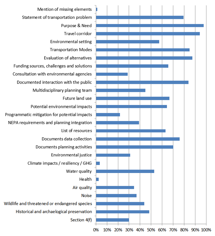
This review assessed the state of the practice for including various PEL elements within transportation corridor plans. This section describes overall observations of corridor plans addressing these elements, organized by the frequency in which the element was included in a plan (see summary table below). It first highlights the most common PEL elements (where the element appeared in 75 percent or more of the plans reviewed), followed by the common though less frequent elements (identified in 25 to 75 percent of plans reviewed, and then the uncommon elements (identified in less than 25 percent of plans reviewed). For several of the assessed elements, a variety of examples are presented in separate call-outs.
Table 1: PEL Elements and Prevalence in Corridor Plan Review
| Category |
Element |
Prevalence |
| All |
Mention of missing elements |
Uncommon |
| Planning |
Transportation problem statement |
Most Common |
| Purpose and need; system vision identification |
Most Common |
| General corridor definition |
Most Common |
| Environmental setting description |
Common |
| Transport mode identification |
Most Common |
| Alternative identification and/or evaluation |
Most Common |
| Funding sources description |
Common |
| Collaboration |
Consultation with environmental agencies |
Common |
| Public involvement documentation |
Most Common |
| Multidisciplinary planning team |
Common |
| NEPA Integration |
Future land use discussion |
Common |
| Potential impacts discussion |
Common |
| Programmatic level mitigation discussion for identified impacts |
Uncommon |
| NEPA integration discussion |
Common |
| Data and Documentation |
List of resources |
Common |
| Data collection documentation |
Most Common |
| Planning activities and analysis documentation |
Common |
| Environmental Impacts (part of NEPA category) |
Environmental Justice |
Common |
| Climate change resiliency, greenhouse gases |
Uncommon |
| Water quality |
Most Common |
| Health |
Uncommon |
| Air quality |
Most Common |
| Noise |
Most Common |
| Wildlife, endangered species |
Most Common |
| Historic preservation |
Most Common |
| Section 4(f) structures |
Most Common |
2.1 Most Common Elements
Clear themes emerged from the set of 87 plans based on the PEL elements most commonly addressed. PEL elements within the Planning category are most represented throughout the sets of plans reviewed, and Data and Documentation elements are also well-represented. Those PEL elements most prevalent (present in 75 percent or greater of plans reviewed) in the set of plans reviewed include:
- Planning
- Statement of a transportation problem, including the problem scope
- Purpose and need or identification of the desired overall system performance
- Definition of the general travel corridor
- Transportation mode
- Identification and/or preliminary evaluation of alternatives
- Collaboration
- Documented interaction and open communication with public
- Data and Documentation
- Documented data collection methods, sources, dates, levels of accuracy, and analysis
2.1.1 Planning
2.1.1.1 Statement of transportation problem, including the problem scope
The transportation problem statement broadly identifies the reason for initiating a planning study. This statement ultimately defines the nature of the plan as a whole, with the scale of the plan reflecting the specificity of the problem statement. Often the transportation problem statement exists within a larger purpose and need statement. Reasons that agencies engage in planning might include:
- Identify priorities for development (or lack thereof)
- Develop alternatives for corridor improvements
- Recommend improvements to facilities
- Understand the demand for transportation infrastructure
- Synthesize ideas amongst multiple plans or proposals
- Guide corridor design
While a majority of the plans reviewed contained a transportation problem statement, there were clear differences in the scale, scope, and specificity of the statements, especially as it relates to the overall Purpose and Need statement (see the next section). Some problem statements were derived from non-transportation inspiration, such as economic growth, request of local government, or simply the passing of several years since the last plan was authored.
The Uinta Basic Energy and Transportation Study provides an example of a plan that identifies a specific transportation problem, in this case traffic congestion due to oil and gas movement:
“Leaders…have recognized growing traffic congestion on the roads…, which has come with increases in energy production. Knowing that further increases…are on the way, leaders began to discuss solutions to the increased traffic congestion.” (Duchesne County, Uintah County, Uintah Transportation Special Service District, & Utah Department of Transportation (UDOT), 2013)
In contrast, another Utah plan, the North Legacy Corridor Supplemental Study has a broader transportation problem statement:
“This study involves the long term planning for growth and transportation needs in Weber county” and “This report is written to address local government coordination of corridor preservation through various planning and zoning powers…” (Wasatch Front Regional Council & Utah Department of Transportation (UDOT), 2009)
2.1.1.2 Purpose and need or identification of the desired overall system performance
Purpose and need is a concept taken from NEPA, and this statement is where the planning process and NEPA most clearly intersect. The purpose and need initiated in the transportation planning process can serve as the starting point for developing the NEPA purpose and need; the more completely it is defined in the planning stage, the less time is needed to develop this foundational element of NEPA.
While the purpose and need statement often accompanies the transportation problem statement, they are independent, as the purpose and need is not necessarily derived directly from transportation issues. The FHWA Corridor Guidance notes that a purpose and need statement:
- Should be a statement of the transportation problem (not a statement of a solution)
- Should be based on articulated planning factors and developed through a certified planning process
- Should be specific enough so that the range of alternatives developed will offer real potential for solutions to the transportation problem
- Must not be so specific as to “reverse engineer” a solution, and
- May reflect other priorities and limitations in the area, such as environmental resources, growth management, land use planning, and economic development. Additionally, the purpose and need also typically includes some degree of visioning, naturally coupling with a broader discussion of desired system performance, even though these may also technically be separate, with the purpose and need statement focusing on system concept and not explicitly system performance.
The purpose and need statement for a transportation project should be consistent with and based on the goals and objectives developed during the planning process.
Among the corridor plans reviewed, the purpose and need statements addressed a range of issues: identification of system performance, plan visioning, and transportation system visioning. While these factors can lay a foundation for a planning study, they do not necessarily meet the definition and intent of the purpose and need statement required as part of the NEPA process. In particular, broader or exploratory corridor plans may not have enough information about the transportation problem to inform a project purpose and need statement or alternatives identification and analysis.
UDOT's I-15 Washington County study provides a transportation problem statement and identifies the plan's purpose in a manner typical of many of the plans reviewed (UDOT, 2008).
I-15 Washington County, Utah
- Transportation problem statement: “I-15 is a part of the CanaMex Corridor and was recently chosen by USDOT as one of the six corridors of the future. As such, the corridor provides an essential transportation and economic link for the western United States, the State of Utah, and local Washington County.”
- Purpose and need statement: “The purpose of this corridor study is to identify existing and future transportation needs along the I-15 corridor in Washington County (MP 0 to 42), to identify potential solutions to meet those needs, and to prioritize those potential solutions into probable projects that can be recommended for inclusion in the 2010 to 2040 Statewide Transportation Improvement Program (STIP).”
2.1.1.3 Definition of the general travel corridor
The travel corridor definition is another fundamental element of the planning process, reflected in the overwhelming inclusion in the plans reviewed. Interestingly, however, not all plans incorporated this element despite its seemingly essential nature. As noted in the FHWA Corridor Guidance, “the general travel corridor is not the specific alignment, but [it] does direct future study of the corridor into one general area.“
Corridor definitions took many approaches in this review, with some describing the physical and geometric layout of the corridor, others describing social and economic qualities of the corridor, and still others describing the performance qualities of the corridor. The scale also varied, with some plans focused at the neighborhood level, others taking a local/city view, and still others describing the corridor in a broader regional context, with the scale of the description only loosely reflecting the overall geographic scale of the plan itself.
2.1.1.4 Transportation mode
The description of the transportation modes is one of the most important defining features of a travel corridor and an essential component of the transportation planning process. The general travel corridor is not the specific alignment, but does direct future study of the corridor into one general area. The FHWA Corridor Guidance indicates that “the planning study does not need to identify both general travel corridor and general mode; it may identify only one of these, or neither.“ Approximately 85 percent of the plans reviewed included a discussion of transportation modes for the corridor under consideration.
South Carolina DOT's I-85 study provides a description of the general travel corridor and the transportation modes (SCDOT, 2012).
I-85, South Carolina
- General travel corridor: “I-85 serves as a primary north-south route for both long-distance and local drivers. This 22-mile stretch of I-85 has 15 interchanges and 35 bridges. One of the major features of the corridor is the interstate-to-interstate interchange at I-85 and I-385…the corridor provides access regionally to both Charlotte and Atlanta, which are both trucking hubs for the southeastern United States. This roadway is currently a main north-south trucking route. The daily percentage of trucks on I-085, as provided by SCDOT, is estimated to be 28%.”
- Transportation mode (selection): “Although bicycles and pedestrians are prohibited from the main facility of a freeway by South Carolina law, there are opportunities to serve both these modes in the I-85 corridor. Within the freeway corridor there is the potential for a shared use path. Shared use paths along a freeway may be within the right-of-way but are usually separated from lanes of traffic. For such a facility, structure must be considered. Bike lanes and sidewalks could also be included in the design of any collector distributor roads in the corridor.”
2.1.1.5 Identification and/or preliminary evaluation of alternatives
Addressing transportation challenges requires identifying reasonable solutions given the resources available. These solutions are then vetted through a detailed fact-finding process. Through this process, the preferred solution or 'alternative' may be identified, dependent on the criteria established early in the planning or project development process.
Transportation corridor plans may influence this alternatives screening process in two ways. First, corridor plans may provide information pertinent to the alternatives identified in NEPA. Second, transportation corridor plans may directly evaluate alternatives and recommend some alternatives not be advanced for further study in NEPA. If transportation corridor plans are to inform a NEPA analysis in this way, detailed documentation of the alternatives not advanced for further study must be included in the corridor study. Assuming the corridor study meets other guidelines for acceptance in NEPA, it may be included as a reference in the subsequent NEPA study. As the intent of the PEL approach is to reduce duplicate analysis and accelerate processes where possible, agencies desiring to initiate the alternatives analysis process in a corridor study should identify and study alternatives in a manner similar to a preliminary NEPA alternatives screen. Thorough documentation will enhance the credibility of the corridor study. Thus, it is reasonable to expect that corridor plans undertaking the alternatives analysis will exhibit a higher level of detail than might be expected in a typical planning document. (FHWA, 2011).
In this review, a large majority of plans (nearly 90 percent) included some identification, evaluation, and/or screening of alternatives, meaning any subsequent NEPA documentation in those corridors could potentially be accelerated as a result of this previous alternatives analysis. It is important to note that while the alternatives identification process was widely documented, the level of detail varied greatly across the plans reviewed. Some of the analysis was detailed enough to be summarized and incorporated by reference into NEPA, potentially eliminating the need for the analysis to be conducted again under NEPA (see below). Others provided less detail and would still require additional analysis under NEPA.
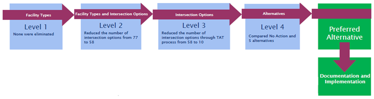
US 50 West, Colorado
Colorado DOT's US 50 West PEL Study: Swallows Rd. to Baltimore Ave. provides a detailed description of the alternatives considered and evaluated, including considerations for each screening and evaluation methodology, specific discussion of each alternative identified, tradeoffs among alternatives, and the selection of a preferred alternative. The plan also describes factors that could cause reconsideration of the preferred alternative in project development, if information relevant to the study area changes. The figure below shows the alternative screening and analysis process used in the US 50 West study. Level 1 screening examined environmental fatal flaws; Level 2 considered traffic operations; Level 3 comparative analysis considered right-of-way, environmental impacts, traffic operations, safety, and cost; Level 4 included a more detailed analysis of selected alternatives and considered mitigation measures. (CDOT, 2012)
2.1.2 Collaboration
2.1.2.1 Documented interaction and open communication with public
Communicating with the public is an essential component of an effective transportation planning process. Planners can provide a forum for community members to learn about identified issues and proposed remedies or alternatives. “Robust outreach and consensus-building as part of a corridor or subarea study ensures that the full range of community issues, opportunities, and ideas are brought to the table while there is still the flexibility to incorporate and address them” (FHWA, 2011).
Transportation plans that provide for public review and a reasonable opportunity to comment during the planning process may be incorporated into NEPA documents, making this another area of notable overlap between the planning and environmental review processes (23 CFR § 450.318, 2007). Documenting the public involvement and input from environmental, regulatory, and resource agencies is particularly important and will strengthen the validity of the planning study for use in NEPA.
Of the plans reviewed, a vast majority provided some documentation of communication with the public; only a handful of plans lacked documentation of public involvement.
2.1.3 Data and Documentation
2.1.3.1 Documented data collection methods, sources, dates, levels of accuracy and analysis
Well-documented data sources contribute to a comprehensive, defensible plan that can be used to inform analyses and decisions later in project development. The age, relevance, and reliability of the data and analysis included in the plan determine the ability for later inclusion in NEPA. Proper data documentation and citation will enable practitioners to more quickly assess the viability of information to be used in a future NEPA document. The best plans will not only cite data sources parenthetically, but also include a complete list of resources and appendices with the relevant data.
Approximately three-quarters of plans in this review generally cited data collection methods, sources, and their dates, although the level of accuracy was typically not discussed.
2.2 Common Elements
The following section outlines the PEL elements that were common in plans (present in 25 to 75 percent of plans reviewed). Their frequency varied across plans and states.
- Planning
- Description of the environmental setting
- Description of funding sources
- Collaboration
- Discussion/consultation with environmental agencies
- Multidisciplinary planning team established
- NEPA
- Discussion of future land use
- Discussion of NEPA Requirements and Planning Integration
- Data and Documentation
- List of resources/studies/plans referenced during the data collection and planning phases
- Documents planning activities, including explanations of thought processes underlying analytical and planning conclusions or decisions
- Environmental Impact Areas
- Environmental justice and social impacts
- Water quality (wetlands, floodplains, rivers, coastal areas, etc.)
- Air quality; conformity; airsheds
- Noise
- Wildlife and threatened or endangered species
- Historical and archaeological resources
- Section 4(f)
2.2.1 Planning
2.2.1.1 Description of the environmental setting
Section 1310 of MAP-21 introduced a provision that a basic description of the environmental setting may be used in planning decisions (Moving Ahead for Progress in the 21st Century, 2012). This provision underlines the importance of how the surrounding environment of a corridor should be used to influence planning decisions. While the description used in most corridor plans will not be thorough enough to meet NEPA standards, the context of the proposed transportation improvements is valuable to the planning study.
Just over 57 percent of the plans reviewed described the environmental setting of the corridor. Of those that did, some plans devoted entire sections to describing the environmental setting, while others only mentioned areas that were relevant to the identified alternatives.
2.2.1.2 Description of funding sources<
Section 135, Statewide Transportation Planning, of
U.S.C.
23, states that a transportation plan “may include a financial plan that demonstrates how the adopted statewide transportation plan can be implemented, indicates resources from public and private sources that are reasonably expected to be made available to carry out the plan, and recommends any additional financing strategies for needed projects and programs” (23 U.S.C 135).
About 66 percent of the plans reviewed mentioned potential funding sources, challenges, and solutions. Funding considerations and proposed sources varied significantly across plans in terms of scope, level of detail, and analysis. Most plans included information about anticipated costs per alternative, but many did not include recommendations for how to pay for an alternative once it was selected.
2.2.2 Collaboration
2.2.2.1 Discussion/consultation with environmental agencies
Early consultation with environmental resource and regulatory agencies enables integration of those agencies' goals into the transportation planning process. Additionally, these environmental agencies may be able to offer useful analysis and resources to the transportation planning process that might otherwise be omitted or left unconsidered. From the FHWA Corridor Guidance: “Resource agencies that have not previously been engaged during the planning process may be hesitant to share data and actively participate in studies if rigorous scientific review or field inspections are not being conducted. When seeking resource and regulatory agency input to planning, it is generally more effective to engage directly with the agencies, such as by inviting agency staff to transportation staff meetings where decisions are being discussed, rather than providing partner resource agencies a planning document to review at the end of the process.”
In order to bring the planning and NEPA processes closer together, documenting discussions with environmental agencies is a valuable component. Some agencies have developed particular comment submission and response documentation procedures that enable clear and complete understanding of resource agency input to the planning process (see box below). This review indicates that the documentation of environmental agency engagement is limited, occurring in just over a quarter of plans reviewed. This is either reflective of an oversight in reporting or limited engagement with environmental agencies.
19th Avenue North Corridor, North Dakota
The 19th Avenue North study summarized interaction with environmental agencies in a tabular format (selection). (Fargo-Moorhead Metropolitan Council of Governments, 2011
| Organization |
Name |
Comment |
| North Dakota Environmental Health Section |
L. David Glatt |
The ND Environmental Health Section believes that environmental impacts from the proposed construction will be minor and can be controlled by proper construction measures. Necessary measures must be taken to minimize fugitive dust emissions created during construction activities. Take care by bodies of water and return disturbed areas back to original conditions as soon as possible after work is completed. Take caution to prevent spills of oil and grease from equipment. Projects disturbing one or more acres are required to have a permit to discharge storm water runoff until the site is stabilized by the reestablishment of vegetation or other permanent cover. Minimize noise effects by ensuring construction equipment is in good working order and construction activities are not conducted during early morning and late evening hours. The department owns no land in or adjacent to the proposed improvements, nor does it have any projects scheduled in the area. (Note: Guidelines for minimizing degradation to waterways were attached to Mr. Glatt's letter.) |
| Nat. Resources Conservation Service |
Jerome M. Scharr |
NRCS
has determined this project is located in an area within city limits where
FPPA
does not apply; therefore, no further action is required. |
| Bureau of Indian Affairs |
Weldon Loudermilk |
The Bureau of Indian Affairs has no environmental objections to this action and finds that the listed action will not affect cultural resources on Tribal or individual landholdings. |
|
FEMA
- US Department of Homeland Security |
David A. Kyner |
FEMA's major concern is if the property is located within a Special Flood Hazard Area, any development in these areas requires further consideration. FEMA recommends that the local Floodplain Manager for Fargo, ND (Mr. R. Strand) is contacted to receive further guidelines regarding the impact that the project might have to the regulations and policies of the National Flood Insurance Program. |
| Department of the Army |
Daniel E. Cimarosti |
Corps regulatory offices administer Section 10 of the Rivers and Harbors Act and Section 404 of the Clean Water Act. If this project requires a permit for these acts, please complete and submit the enclosed Department of the Army permit application to the U.S. Army Corps of Engineers. |
| U.S. Fish and Wildlife Service |
Jeffrey K. Towner |
No Action. The Fish and Wildlife Service is unable to comment on this project due to funding or staff constraints. This does not constitute a report of the Department of the Interior in accordance with the Fish and Wildlife Coordination Act (16 U.S.C. 661 et. seq.). |
| ND Parks and Recreation |
Jesse Hanson |
The project does not affect state park lands managed by ND Parks and Recreation. There are concerns regarding Land and Water Conservation Fund (LWCF) recreation sites near the project area (#38-000858: Fargo Neighborhood Parks, #38-00346: Fargo Riverfront Parks #2). These parks are under protection of section 6(f) of the LWCF Act. Based on the review of the ND Natural Heritage biological conservation database, there are several occurrences of plant or animal species of concern within or adjacent to the project area. (Note: Spreadsheets and maps with more specific project and species locations were attached to Mr. Hanson's letter.) |
2.2.2.2 Multidisciplinary planning team established
While a multidisciplinary planning team is not mandated in transportation planning, a planning perspective that represents varied interests and expertise may lead to more informed decision-making. Incorporating multidisciplinary planning from the early stages of transportation planning is beneficial for creating a plan that can gain a consensus.
About 45 percent of planning teams involved in developing the corridor plans included internal and external stakeholders. The planning teams ranged from state and local governments to MPOs to external consultants.
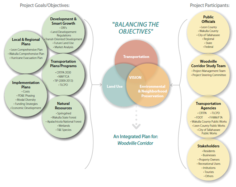
Florida's Woodville Highway South Corridor Study provides an example of how including a variety of stakeholders and information from other planning efforts can be used simultaneously to create an integrated plan that considers a range of community goals (Capital Region Transportation Planning Agency, 2011) (see Figure 1).
Figure 1: Balancing the Objectives, An Integrated Approach (Source: Woodville Highway South Corridor Study)
Extended Image Description →
2.2.3 NEPA
2.2.3.1 Discussion of future land use
FHWA Interim Guidance on the Application of Travel and Land Use Forecasting in NEPA notes that land use forecasting is critical to project development and NEPA processes (FHWA, 2010). Future land use can form the basis of future travel demand, so planners must come to a consensus on future development before the NEPA process is started.
A majority (about 67 percent) of the plans reviewed included information about future land use, and many of the plans referenced existing planning documents that outlined plans for future growth and land use changes in the region that would affect the corridor study area.
2.2.3.2 Discussion of NEPA requirements and planning integration
The FHWA Corridor Guidance states that corridor and subarea plan source material “produced by, or in support of, the transportation planning process may be incorporated directly or by reference into subsequent NEPA documents.” Of the plans reviewed, only 39 percent mentioned NEPA and whether or not each plan could inform a NEPA process in the future. While the plans that did mention NEPA were from a number of different States, many of the plans that mentioned NEPA were from Montana (12 out of 34).
Winifred to Big Sandy Corridor Study, Montana
Montana plans reviewed consistently (with the exception of one) discuss NEPA and whether or not the study may be used to inform NEPA in the future. The specific wording varies from study to study, but the below text is a good example of
MDT's incorporation of NEPA into its plans. (Chouteau County; Fergus County, 2011)
The corridor planning study is a pre-National Environmental Policy Act/Montana Environmental Policy Act (NEPA/MEPA) process that allows for earlier planning level coordintation with the public, stakeholders, resource and other agencies. The major elements of the study are:
- Analysis of transportation and environmental conditions
- Consultation and coordination with local officials, stakeholders, and the public
- Identification of corridor needs and improvement options
- Development of planning level cost estimates and investigation of potential funding sources
The results of the study may be used to assist in determining the level of environmental documentation required if a project is forwarded into project development. The study does not determine a specific set of projects for the corridor, but instead defines improvement options that may be considered within three implementation scenarios.
2.2.3.3 Environmental Impact Areas
FHWA regulations state that corridor and subarea planning “may result in preliminary identification of environmental impacts and environmental mitigation” (23 CFR § 450.212 and 318; 23 CFR 771.111, 2007). A variety of analyses and information types from the transportation planning process can be used to determine these impacts, which may include: identifying environmental resources and environmentally sensitive areas, descriptions of airsheds and watersheds, projections of land use, natural resource conservation areas, and development, and the outputs of natural resource planning efforts, such as wildlife conservation plans, watershed plans, special area management plans, and multiple species habitat conservation plans.
This review searched for inclusion or exclusion of the following environmental impact areas:
- environmental justice and social impacts,
- climate impacts, resiliency, and greenhouse gases,
- water quality (wetlands, floodplains, rivers, coastal, etc.)
- health,
- air quality, conformity, and airsheds,
- noise,
- wildlife and threatened or endangered species,
- historical/archaeological preservation, and
- Section 4(f).
A majority of the plans included at least some information about the environmental impact areas in the above list; however none of the plans included discussion about all of the impact areas included in this review. Thirty-one percent of plans did not discuss any environmental impact areas.
The environmental impact areas that were commonly addressed in the corridor plans are described below.
2.2.3.3.1 Environmental justice and social impacts
Executive Order 12898 directs each Federal agency to make environmental justice part of its mission (Executive Order 12898, 1994). Through internal Orders, USDOT and FHWA are committed to promoting environmental justice principles by incorporating them into all DOT and FHWA programs, policies, and activities (FHWA, 2013). Though
EO
12898 is not statutory, and thus non-enforceable, the Order emphasized that existing environmental and civil rights statutes provide opportunities to address
EJ.
Thirty-one percent of plans included information about potential environmental justice and social impacts. These considerations were predominately included in Arizona, Montana, and North Dakota plans. Almost every Arizona plan included considerations about environmental justice, and those that did included separate sections that discussed environmental justice impacts in detail (see example below).
Germann Road Corridor Improvement Study, Arizona
The Arizona Department of Transportation (ADOT) included a separate section, outside of the environmental setting or environmental impacts sections, that specifically addressed environmental justice (see excerpts). (ADOT, 2013)
2.3 Environmental Justice
2.3.1 Background
Title VI of the Civil Rights Act of 1964 and subsequent related statutes prohibit discrimination on the basis of race, color, national origin, age, sex, and disability in association with any program or activity receiving federal financial assistance. Executive Order 12898, “Federal Actions to Address Environmental Justice in Minority Populations and Low-Income…”
2.3.2 Environmental Justice Considerations
An assessment of the demographic composition of the study area was based on data available through the American Community Survey (ACS) published by the U.S Census Bureau. Detailed information from the 2010 Census is available by tract only for population characteristics. Economic and income information is available only through the 2005-2009 ACS compilations. The 2010 data are reported for different Census Tract boundaries; however, the information provided for both periods is valid and adequate for assessing potential impacts on minority and low-income population characteristics of the study area.
2.2.3.3.2 Water quality (wetlands, floodplains, rivers, coastal areas, etc.)
Dating back to the Clean Water Act of 1972, many regulations and guidance have been issued to protect various water sources in the U.S., including wetlands, floodplains, rivers, coastal areas, and more. Just over half of the plans reviewed discussed potential impacts to water quality in some capacity. The study location likely determined whether or not a plan included information regarding various water resources.
2.2.3.3.3 Air quality, conformity, and airsheds
Similar to water quality, air quality has been regulated since the early 1970s when the first version of the Clean Air Act was published (Clean Air Act of 1970). As a required environmental consideration under NEPA, FHWA transportation projects should document potential impacts to air quality and develop mitigation strategies if impacts are anticipated (National Environmental Policy Act of 1969).
About 34 percent of plans mentioned potential impacts to air quality or conformity. Plans that considered air quality impacts were largely found in Arizona, Montana, New Mexico, and Massachusetts plans.
2.2.3.3.4 Noise
Highway traffic noise and construction noise must be investigated in project development, according to 23 CFR § 772 of the Federal-Aid Highway Act of 1970. The Noise Control Act of 1972 and NEPA also regulate the impacts of noise on communities.
Mentions of noise impacts essentially mirrored mentions of air quality impacts and were included most often in Arizona, Montana, New Mexico, and Massachusetts plans.
2.2.3.3.5 Wildlife and threatened or endangered species
Numerous regulations, including NEPA, the Clean Water Act, and the Endangered Species Act, require Federal agencies to consider transportation impacts on wildlife and threatened or endangered species (FHWA).
Approximately 44 percent of plans mentioned some aspect of potential impacts to wildlife. Every Montana plan reviewed in this study included them.
2.2.3.3.6 Historical and archaeological preservation
Legislation and regulations dating as far back as the American Antiquities Act of 1906, require Federal agencies to consider the potential impacts transportation projects may have on historical and archaeological resources. Nearly half (48 percent) of the plans reviewed discussed historical and / or archaeological preservation. Once again, every Montana plan included this information.
2.2.3.3.7 Section 4(f)
Section 4(f) of the Department of Transportation Act (DOT Act) of 1966 stipulated that FHWA and other DOT agencies “cannot approve the use of land from publicly owned parks, recreational areas, wildlife and waterfowl refuges, or public and private historical sites unless there is no feasible and prudent alternative to the use of land, and the action includes all possible planning to minimize harm to the property resulting from use” (DOT Act of 1966). The term historic sites includes prehistoric and historic districts, sites, buildings, structures or objects listed in, or eligible for, the National Register of Historic Places. This may also include places of traditional religious and cultural importance to an Indian tribe or Native Hawaiian organization and that meet the National Register criteria.
Despite being an important consideration under federal law, only about 30 percent of the plans mentioned Section 4(f) when considering environmental impacts.
2.2.4 Data and Documentation
2.2.4.1 List of resources/studies/plans referenced during the data collection and planning phases
About 63 percent of the plans reviewed included a list of resources, studies, planning documents, and tools that were used to collect and analyze data. Many plans included resources and plans within the background or introductory section of the document rather than compiling a complete list of all resources used or referenced. Few plans provided a comprehensive “reference” or “resources” list at the conclusion of the document.
2.2.4.2 Documents planning activities, including explanations of thought processes underlying analytical and planning conclusions/decisions
It is important for anyone reading a corridor plan to be able to understand why the authors of the plan came to their decisions. Including planning activities, planning principles followed, and thought processes of the planners allows a reader to follow the decision-making process easily.
The majority of plans (70 percent) explained—in detail—why planning conclusions and decisions were made based on a variety of planning activities and analytical processes. The level of detail varied among the plans, but overall, most plans provided sufficient information about why certain information was included, why resources were referenced, and how conclusions were reached.
2.3 Uncommon Elements
This section describes the PEL elements that were least prevalent (present in fewer than 25 percent of plans reviewed). The PEL elements that appeared in few of the plans reviewed include:
- Mention of missing elements
- Identification of programmatic level mitigation for potential impacts
- Environmental Impact Areas
- Climate impacts/resiliency/greenhouse gases
- Health
2.3.1 Mention of missing elements
While every effort is made to deliver a complete planning process that encompasses all pertinent information, limitations in resources, funding, timing, or availability often mean that the most appropriate information is not always included. The development of a self-critical plan that notes shortcomings allows agencies to plan for next steps with increased awareness. Documentation of missing elements or topics not addressed in planning can also be helpful for NEPA practitioners to understand what further analysis is needed in project development. Additionally, this documenting procedure, when multiplied across many plans and agencies, also further develops the state-of-the-practice by highlighting specific elements whose inclusion is to be improved. In this review, discussion of missing elements was exceedingly rare, as only a single plan explicitly mentioned pertinent information not considered in the plan.
2.3.2 NEPA
2.3.2.1 Identification of programmatic level mitigation for potential impacts
Planning studies can be a catalyst to start interagency discussions about potential mitigation options, priorities, and strategies for proposed projects. Options for mitigation include the development of advanced mitigation agreements or mitigation banking, among others. The FHWA corridor guidance states that the information generated during a planning study needs to be detailed enough to support planning-level decisions for environmental mitigation (FHWA). In addition, this identification of programmatic level mitigation can be used to inform NEPA documents. Only 22 percent of plans reviewed in this study identified programmatic level mitigation for potential impacts.
US 17 Area Plan, Florida
The Charlotte County, Florida, US 17 corridor study describes wetland mitigation options if impacts are unavoidable. (Charlotte County, 2010)
“If development will result in adverse effects to the existing ecological function provided by the subject wetland, mitigation will be required. Mitigation can be provided through numerous means both on-site and/or offsite. One option for mitigation is to purchase wetland credits from an approved Wetland Mitigation Bank. Fortunately, two mitigation banks meet the necessary criteria to be viable options for provision of offsite mitigation required for future wetland impacts.”
2.3.2.2 Environmental Impact Areas
Below are the uncommon environmental impact areas found in this review. Section 2.2.3.3 discusses the more frequently referenced environmental impact areas.
2.3.2.2.1 Climate impacts, resiliency, and greenhouse gases
Climate impacts are not required under federal planning regulations or NEPA, so it is not surprising that only three plans mentioned climate impacts. The New Mexico Department of Transportation (NMDOT), for instance, included “air quality / climate change” in its evaluation of alternatives in the I-25 corridor plan. “Climate change” in this instance referred to reductions in vehicle emissions.
2.3.2.2.2 Health
While considering health is not explicitly part of the federally required transportation planning process, FHWA recognizes the impact of transportation infrastructure on public health, and supports State DOTs and MPOs that consider health throughout the transportation planning process (FHWA, 2014).
Only two plans mentioned health with regards to environmental impacts.
MassDOT's McGrath Highway/Route 28 corridor plan included information on health impact assessments, and Fargo-Moorhead Metropolitan Council of Governments' 19th Avenue North corridor plan included a “ND environmental health impacts” section.
Back to Table of Contents
3. Conclusions
PEL is intended to foster a closer relationship between transportation planning and the NEPA process. This linking prevents duplication of effort, promotes environmental stewardship, and reduces delays in project implementation. The review of the corridor plans found that in states that have adopted the PEL questionnaire or an equivalent process, the PEL approach is being integrated into the planning process.
Key findings include:
- Fundamental transportation elements were highly prevalent among the transportation corridor plans reviewed. The PEL elements that transportation agencies regularly address within the transportation plans include the transportation problem statement, purpose and need, corridor definition, transportation mode, and identification/evaluation of alternatives. While most of the plans included these definitional Planning elements, they varied greatly in level of detail from plan to plan. While this may reflect the complex variety of transportation issues that exist, the level of detail also affects the ability of particular plans to inform NEPA. A primary goal for PEL is the ability for plans to interface with NEPA requirements and documentation, but given a large variance in plan visioning, some plans may not integrate into NEPA seamlessly.
- Many plans in this review left in-depth assessment of potential environmental impacts for future analysis. This is partially reflective of the broad scope of some plans reviewed. Plans serving a broader visioning role were more likely to omit discussion of particular impacts and mitigation measures, as this was deemed more appropriate for future planning efforts that identify and evaluate specific alternatives.
- Emerging issues, such as climate change and health, were addressed in few plans. Topics that are not explicitly required as part of the federally required transportation planning or NEPA process were not generally addressed in the corridor plans.
- Collaboration and stakeholder involvement varied. Involving and communicating with stakeholders and the public regarding transportation plans is a fundamental element of the planning process. Documentation of the public process was prevalent in most of the plans reviewed for this report. Related to the public process is the inclusion of appropriate stakeholders. Many plans did not assemble diverse planning teams, nor consult with environmental agencies. Planning teams often included a mix of disciplines (planning, engineering, and public safety, for example), but did not incorporate a wide representation of the community. Few planning teams incorporated a variety of members from local, regional, state, and federal levels. The stakeholders in a particular planning process can greatly affect the outcome and decisions made. As a result, teams with a limited variety of stakeholders, especially environmental personnel, may not best address environmental resource and other issues that may be raised later in project development, resulting in the need for additional consultation at a later time.
Back to Table of Contents
4. Works Cited
| 23 C.F.R § 450, Appendix A, 2007. (n.d.). |
| 23 C.F.R § 450.318. (n.d.). |
| 23 CFR § 450, 2007. (n.d.). |
| 23 CFR § 450.212 and 318; 23 CFR 771.111, 2007. (n.d.). |
| 23 CFR § 450.318, 2007. (n.d.). |
| 23 CFR § 771, 2007. (n.d.). |
23 U.S.C 135. (2011). Retrieved from U.S. Government Printing Office:
https://www.govinfo.gov/content/pkg/USCODE-2011-title23/html/USCODE-2011-title23-chap1-sec135.htm |
ADOT. (2013). Germann Road Corridor Improvement Study. Retrieved from
https://azdot.gov/planning/transportation-programs/planning-assistance-rural-areas-para-program/completed-planning |
Capital Region Transportation Planning Agency. (2011, June). Woodville Highway South Corridor Study. Retrieved from CRTPA.org:
http://crtpa.org/files/65911545.pdf |
CDOT. (2012). US 50 West PEL Study: Swallows Rd. to Baltimore Ave. Retrieved from
https://www.codot.gov/library/studies/us-50-west-pel-study/us-50-west-pel-study |
Charlotte County. (2010). US 17 Area Plan Corridor Study. Retrieved from
No longer available online.
|
Chouteau County; Fergus County. (2011). Winifred to Big Sandy Corridor Study. Retrieved from
https://www.mdt.mt.gov/pubinvolve/winifred/docs/final_study.pdf |
Clean Air Act of 1970. (1970). Clean Air Act of 1970. Retrieved from U.S. Government Printing Office:
https://www.govinfo.gov/content/pkg/USCODE-2008-title42/pdf/USCODE-2008-title42-chap85.pdf |
DOT Act of 1966. (1966). Department of Transportation Act of 1966. Retrieved from U.S. Government Printing Office:
https://www.govinfo.gov/content/pkg/STATUTE-80/pdf/STATUTE-80-Pg931.pdf |
Duchesne County, Uintah County, Uintah Transportation Special Service District, & Utah Department of Transportation (UDOT). (2013). Uinta Basin Energy and Transportation Study Phase 1. Retrieved from
https://www.udot.utah.gov/projectpages/TIGSOWNER.gf?f=App%20F%20-%20UBETS%20Final%20Report%20April%202013%20-%20Rev%201.pdf |
Executive Order 12898. (1994, February 11). Executive Order 12898. Retrieved from U.S. Government Printing Office:
https://www.govinfo.gov/content/pkg/FR-1994-02-16/html/94-3685.htm |
Federal Highway Administration. (2013). Highway Traffic Noise; Highway Traffic and Construction Noise - Regulation and Guidance. Retrieved from U.S. Department of Transportation Federal Highway Administration:
https://www.fhwa.dot.gov/environment/noise/regulations_and_guidance/ |
FHWA. (2006). Planning and Environment Linkages. Retrieved from U.S. Department of Transportation Federal Highway Administration:
www.environment.fhwa.dot.gov/Env_initiatives/PEL.aspx |
FHWA. (2010, March). Environmental Review Toolkit, Interim Guidance on the Application of Travel and Land Use Forecasting in NEPA. Retrieved from U.S. Department of Transportation Federal Highway Administration:
www.environment.fhwa.dot.gov/nepa/Travel_LandUse/travel_landUse_rpt.aspx |
FHWA. (2010). Shortening Project Delivery Toolkit. Retrieved from U.S. Department of Transportation Federal Highway Administration:
https://www.fhwa.dot.gov/innovation/everydaycounts/edc-1/PEL.cfm |
FHWA. (2011, April 5). Guidance on Using Corridor and Subarea Planning to Inform NEPA. Retrieved from U.S. Department of Transportation Federal Highway Administration:
www.environment.fhwa.dot.gov/Env_initiatives/PEL/corridor_nepa_guidance.aspx |
FHWA. (2012). Environmental Review Toolkit Section 4(f) Program Overview. Retrieved from U.S. Department of Transportation Federal Highway Administration:
www.environment.fhwa.dot.gov/legislation/section4f.aspx |
FHWA. (2013). Environmental Justice. Retrieved from U.S. Department of Transportation Federal Highway Administration:
https://www.fhwa.dot.gov/environment/environmental_justice/ |
FHWA. (2014, June 26). Heath in Transportation Frequently Asked Questions. Retrieved from U.S. Department of Transportation Federal Highway Administration:
https://www.fhwa.dot.gov/planning/health_in_transportation/faq/ |
FHWA. (n.d.). Environmental Review Toolkit; Historic Preservation Program Overview. Retrieved from U.S. Department of Transportation Federal Highway Administration:
www.environment.fhwa.dot.gov/env_topics/historic_preservation.aspx |
FHWA. (n.d.). Environmental Review Toolkit; Water, Wetlands, and Wildlife - Legislation, Regulation and Policy. Retrieved from U.S. Department of Transportation Federal Highway Administration:
www.environment.fhwa.dot.gov/env_topics/topics_home.aspx |
Moving Ahead for Progress in the 21st Century. (2012, January 3). Moving Ahead for Progress in the 21st Century. Retrieved from U.S. Government Printing Office:
https://www.govinfo.gov/content/pkg/BILLS-112hr4348enr/pdf/BILLS-112hr4348enr.pdf |
National Environmental Policy Act of 1969. (1969). National Environmental Policy Act of 1969. Retrieved from Energy.gov:
https://www.energy.gov/nepa/downloads/national-environmental-policy-act-1969 |
Safe, Accountable, Flexible, Efficient Transportation Equity Act: A Legacy for Users Act of 2005. (2005, August 10). Safe, Accountable, Flexible, Efficient Transportation Equity Act: A Legacy for Users Act of 2005. Retrieved from U.S. Government Printing Office:
https://www.govinfo.gov/content/pkg/PLAW-109publ59/pdf/PLAW-109publ59.pdf |
SCDOT. (2012). I-85 Corridor Analysis Project. Retrieved from
http://www.85385gateway.com/corridor.aspx |
UDOT. (2008). I-15 Washington County Corridor Study. Retrieved from
https://www.udot.utah.gov/projectpages/TIGSOWNER.gf?f=I-15%20Corridor%20Summary%20Page.pdf, |
| Wasatch Front Regional Council, & Utah Department of Transportation (UDOT). (2009). North Legacy Transportation Corridor Supplemental Study. No longer available.
|
Back to Table of Contents
Appendix A: List of Corridor Plans
| State |
Corridor Plan |
Organization |
Year |
| Alaska |
College Road Corridor Study |
FMATS |
2013 |
| Arizona |
Germann Road Corridor |
ADOT |
2013 |
| Arizona |
City of Kingman Stockton Hill Road |
ADOT |
2013 |
| Arizona |
Meridian Road Corridor Study |
ADOT |
2013 |
| Arizona |
Sundog Connector |
ADOT |
2013 |
| Arizona |
Sahuarita/El Toro |
ADOT |
2013 |
| Arizona |
Yuma Expressway Study |
ADOT |
2013 |
| Arizona |
Town of Camp Verde Business Corridor |
ADOT |
2013 |
| Arizona |
SR
169 to Fain Road |
Central Yavapai |
2009 |
| Arizona |
Chino Valley Extension |
Central Yavapai |
2009 |
| Arizona |
Townsend Winona |
Flagstaff MPO |
N/A |
| Arizona |
Fourth Street |
Flagstaff MPO |
N/A |
| Florida |
Oakland Park Boulevard |
Broward County MPO |
2009 |
| Florida |
Woodville Highway (South) |
Capital Region Transportation Planning Agency |
2011 |
| Florida |
US 17 |
Charlotte County-Punta Gorda MPO |
2010 |
| Florida |
East Hillsborough Avenue |
Hillsborough County MPO |
2013 |
| Florida |
Curlew Road |
Pinellas County |
2009 |
| Indiana |
Mount Comfort Road |
Indianapolis MPO |
2008 |
| Massachusetts |
McGrath Highway/Route 28 |
Mass DOT |
2013 |
| Massachusetts |
I-495/Rt 9 |
Mass DOT |
2012 |
| Massachusetts |
I-95 |
Mass DOT |
2010 |
| Massachusetts |
Shank Painter Road, Provincetown |
Cape Cod Commission |
2012 |
| Massachusetts |
Yarmouth Road, Barnstable |
Cape Cod Commission |
2012 |
| Massachusetts |
I-495 Corridor from Westford to Salisbury |
Northern Middlesex
COG |
2008 |
| Massachusetts |
Rt 139 |
Old Colony Planning Council |
2010 |
| Massachusetts |
Rt 58 |
Old Colony Planning Council |
2010 |
| Massachusetts |
Rt 18 |
Old Colony Planning Council |
2009 |
| Massachusetts |
Rt 27 |
Old Colony Planning Council |
2008 |
| Massachusetts |
I-495 |
Southeastern Massachusetts MPO |
2009 |
| Massachusetts |
Washington Street/Oak Street |
Southeastern Massachusetts MPO |
2009 |
| Mississippi |
US 49 |
MDOT |
2013 |
| Montana |
I-90 |
MDT |
2012 |
| Montana |
MT 78 |
MDT |
2008 |
| Montana |
Winifred to Big Sandy |
MDT |
2011 |
| Montana |
MT-1 |
MDT |
2011 |
| Montana |
Toston Missouri River Crossing |
MDT |
2011 |
| Montana |
Culbertson |
MDT |
2012 |
| Montana |
MT 16/MT 200 |
MDT |
2012 |
| Montana |
Tongue River Road |
MDT |
2012 |
| Montana |
North Fork Flathead Road |
MDT |
2010 |
| Montana |
US 2 - Badrock Canyon |
MDT |
2012 |
| Montana |
US 93 |
MDT |
2008 |
| Montana |
Paradise Valley, US 89 (Gardiner to Livingston) |
MDT |
2013 |
| Montana |
US-93 Polson |
MDT |
2011 |
| New Mexico |
Salt Missions Trail Scenic Byway |
Mid-Region COG |
2011 |
| New Mexico |
I-25 |
NMDOT |
2009 |
| New Mexico |
St. Francis Drive through the City of Santa Fe |
NMDOT |
2010 |
| New Mexico |
I-40 |
NMDOT |
2010 |
| North Carolina |
NC54-I40 |
NCDOT |
2011 |
| North Carolina |
NC 107 |
Southwestern Rural Planning Organization |
2012 |
| North Carolina |
NC 50 |
Capital Area MPO/LPA |
2011 |
| North Carolina |
High Point Road, West Lee Street |
Greensboro Urban Area |
2008 |
| North Carolina |
US 29-70 |
High Point MPO |
2010 |
| North Carolina |
NC 24 |
Jacksonville MPO |
2011 |
| North Carolina |
Dow Road |
Wilmington Urban Area MPO |
2009 |
| North Carolina |
Market Street |
Wilmington Urban Area MPO |
2010 |
| North Carolina |
US 17/NC210 |
Wilmington Urban Area MPO |
2012 |
| North Dakota |
43rd Avenue |
Bismarck-Mandan MPO |
2013 |
| North Dakota |
Lincoln Road |
Bismarck-Mandan MPO |
2011 |
| North Dakota |
Mandan Memorial Highway |
Bismarck-Mandan MPO |
2010 |
| North Dakota |
Regional North-South Beltway |
Bismarck-Mandan MPO |
2009 |
| North Dakota |
9th Street/Veterans Blvd |
Fargo-Moorhead Metropolitan Council of Governments |
2012 |
| North Dakota |
19th Avenue North |
Fargo-Moorhead Metropolitan Council of Governments |
2011 |
| North Dakota |
Fargo - Main Avenue |
Fargo-Moorhead Metropolitan Council of Governments |
2013 |
| North Dakota |
Moorhead 10/75/Center |
Fargo-Moorhead Metropolitan Council of Governments |
2013 |
| North Dakota |
Red River Greenway |
Fargo-Moorhead Metropolitan Council of Governments |
2008 |
| North Dakota |
47th Avenue South |
Grand Forks - East Grand Forks MPO |
2011 |
| North Dakota |
Minnesota/Fourth Avenue |
Grand Forks - East Grand Forks MPO |
2008 |
| Pennsylvania |
Kinzua Bridge Byway |
PennDOT |
2009 |
| Pennsylvania |
Hallowed Ground |
PennDOT |
2008 |
| Pennsylvania |
US Route 19 |
Mercer County Regional Planning Commission |
N/A |
| South Carolina |
Statewide |
SCDOT |
2013 |
| South Carolina |
I-85 |
SCDOT |
2012 |
| South Carolina |
I-77 |
Rock Hill-Fort Mill ATS |
2008 |
| Tennessee |
Lamar Avenue |
TDOT |
2011 |
| Tennessee |
U.S. Highway 321 |
Knoxville Urban Area MPO |
2010 |
| Utah |
North Legacy |
UDOT |
2009 |
| Utah |
Uinta Basin |
UDOT |
2013 |
| Utah |
I-15, Washington County |
UDOT |
2009 |
| Utah |
Cache Valley South Corridor |
Cache MPO |
2011 |
| Utah |
Foothill Drive |
Wasatch Front Regional Council |
2008 |
Back to Table of Contents
Appendix B: Review Template
Name of State – Corridor Plan PEL Inclusion Reviews
1. Name of Corridor Study
Plan and
URL:
Organization:
Year:
Exemplary? Choose Y/N
If Y, please elaborate: |
| Criteria |
Description |
Reference |
| ALL ELEMENTS |
| Plan mentions missing elements (data not collected, resources not used, parties not included) |
|
|
| PLANNING ELEMENTS |
| Transportation problem |
|
|
| Purpose and Need of Study, or Desired overall system performance (vision, goals, measures) |
|
|
| Definition of general travel corridor |
|
|
| Description of the environmental setting |
|
|
| General transportation modes - identification and evaluation |
|
|
| Transportation Alternatives - identification and analysis (may include screening criteria) |
|
|
| Funding (sources, challenges) |
|
|
| COLLABORATION ELEMENTS |
| Environmental agencies consulted |
|
|
| Public involvement |
|
|
| Multidisciplinary planning team |
|
|
| NEPA ELEMENTS |
| Future land use |
|
|
Potential impacts:
Environmental justice and social impacts;
Climate impacts/resiliency/greenhouse gases;
Water quality (including wetlands, floodplains, rivers, coastal, etc.);
Wildlife and threatened or endangered species;
Health;
Air quality;
Noise;
Historic and archaeological preservation;
Section 4(f) |
|
|
| Identification of programmatic level mitigation for potential impacts |
|
|
| Mention of whether or not environmental information and analyses in the plan can be used to inform NEPA |
|
|
| DATA/DOCUMENTATION ELEMENTS |
| List of resources/studies/plans referenced |
|
|
| Description of all data used (sources, dates/age) |
|
|
| Planning activities (explanations of thought processes underlying analytical and planning conclusions / decisions |
|
|
Back to Table of Contents
Appendix C: Summary of Results
PEL Elements Included in Corridor Plans Reviewed
Extended Image Description →
Back to Table of Contents

