
Planning for Climate Change: FHWA’s Climate Change Resilience Pilot Program
Increasing temperatures, sea level rise (SLR), changes in seasonal precipitation, and more intense and frequent storm events are creating costly challenges and presenting new safety risks for transportation agencies across all levels of government. To prepare the Nation’s transportation systems to handle the effects of a changing climate, the Federal Highway Administration (FHWA) partnered with State and local transportation agencies to establish the Climate Resilience Pilot Program in 2010, which began with five pilot projects that were completed in 2011. These pilots were intended to help State Departments of Transportation (DOTs), Metropolitan Planning Organizations (MPOs), and Federal land management agencies enhance the resilience of their transportation systems to extreme weather and climate change.
In 2013, the FHWA Office of Environment, Planning, and Realty and the FHWA Office of Infrastructure initiated a second round of pilots by selecting 19 projects across the country to assess transportation vulnerability to climate change and extreme weather events, and evaluate options for improving resilience.
Climate Resilience 101: Key Terms
Resilience or resiliency: The ability to anticipate, prepare for, and adapt to changing conditions and withstand, respond to, and recover rapidly from disruptions.
Exposure: Whether the asset or system is located in an area experiencing direct impacts of climate change.
Sensitivity: How the asset or system fares when exposed to an impact.
Adaptive capacity: The system’s ability to adjust to and cope with existing or future climate variability and impacts.
Vulnerability: In the transportation context, it is a function of a transportation system’s exposure to climate effects, sensitivity to climate effects, and adaptive capacity.
FHWA’s Vulnerability Assessment Framework Lays Groundwork for Agencies to Prepare for Climate Change
FHWA’s Climate Resilience Pilot Program includes webinars, peer exchanges, and information-sharing, through speaking engagements, case studies, and online resources. The pilots also used the “Climate Change and Extreme Weather Vulnerability Assessment Framework,” a guide to analyzing the impacts of climate change and extreme weather on transportation infrastructure, and they provided feedback on its content and structure to FHWA.
The framework helps transportation agencies identify key considerations, questions, and resources that can be used to develop and implement a climate change vulnerability assessment. Using the framework, the pilot agencies defined the scope of their projects, assessed vulnerability of specific transportation assets, and considered ways to integrate results into their decisionmaking. Throughout the process, FHWA helped the pilot agencies share ideas and lessons learned amongst one another, as well as with DOTs, MPOs, and their communities.
Incorporating the results of the vulnerability assessment into the agency’s decisionmaking process ensures that the assessment results are used in practice. An agency may use the results of the vulnerability assessment in its asset management programs, hazard mitigation plans, transportation planning project selection criteria, or other programs and processes. Integrating these results can lead to more complete transportation planning and informed practice. In addition, a transportation agency might be interested in using the results of the analysis to inform the development of specific adaptation strategies for assets identified as highly vulnerable to climate change.
MTC Pilot Partners
- The San Francisco Bay Conservation and Development Commission
- The California Department of Transportation, District 4
- San Francisco Bay Area Rapid Transit District
Currently, FHWA is updating the framework with experiences and lessons learned from this latest round of pilot projects. Two projects are briefly described below.
Partnering to Assess Multimodal Adaptation in San Francisco
The Metropolitan Transportation Commission (MTC), the San Francisco Bay Area’s metropolitan planning organization, and its partners collaborated on a sub-regional pilot project to assess adaptation options for important transportation assets vulnerable to SLR in Alameda County. This work expanded on information collected from a previous FHWA climate change pilot project completed in 2011.
The 2010-2011 study developed detailed risk profiles for approximately 30 transportation assets including roads, rail, and transit in Alameda County. The refined vulnerability assessment identified three types of exposed areas—shoreline inundation, critical inundation pathways, and inland inundation areas. From these risk areas, the new pilot project selected three focus areas within Alameda County for further study. MTC and its partners then developed a set of detailed, representative adaptation strategies to potentially protect bridge, highway, transit, and community assets from future inundation. After refining these suggested strategies through an evaluation process, MTC and its partners selected five adaptation strategies for further development.
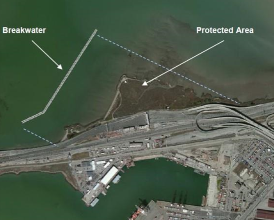
A breakwater placement and offshore configuration of Radio Beach, on the San Francisco Bay shoreline, would minimize wave action and overtopping of the levee as the sea level rises. (Courtesy of MTC)
Two of the five proposed strategies focused on the San Francisco-Oakland Bay Bridge toll plaza. These included a “living levee” (a vegetated levee with a gradual slope on the Bay side), and an offshore breakwater (a barrier that protects the shoreline from the full force of waves) to reduce wave impacts. The levee would protect against future inundation and flooding due to SLR and storm surge, and its seaward slope would provide new intertidal and marsh habitat. The breakwater would reduce wave heights and protect the area from future wave overtopping, which occurs when wave heights surpass the height of a structure and flood over it, and wave-induced erosion.
The study proposed a living levee and sea wall for the areas near the O.co Coliseum, a multi-purpose stadium in Oakland. Finally, a drainage study was recommended for the San Mateo-Hayward Bridge area. These strategies encompass physical and policy-based options, as well as future research needs.
Additional studies will be required for some of these proposals, but some could be implemented without extensive research.
Improving Vulnerable Road and Stream Crossings in New York State
More than one million culverts lie beneath highways and roads across the State of New York. Effective culverts allow water, fish, and wildlife to travel without interruption, but compromised, under-sized, or poorly designed culverts can create “pinch points” and are often the starting point of flood damage. Recent severe storms have underscored the intrinsic significance of culverts in helping communities gain resiliency in a changing climate.
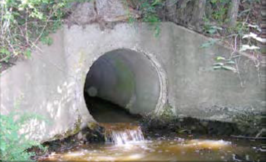
Undersized crossings restrict natural stream flow and can cause problems during floods. (Courtesy of TNC)
The New York State Department of Transportation (NYSDOT) in collaboration with The Nature Conservancy (TNC) assessed the impacts of increased temperature, precipitation, and frequency of extreme storms in the rural Lake Champlain Basin. Storm events and associated flooding are increasingly overwhelming local culverts—the area experienced two record-breaking flood events in the last five years, but the funding required to recover from the damages far exceeds local budgets.
In discussing adaptation options, NYSDOT and TNC were concerned about the triple bottom line—ecological impacts (fish, habitat, water quality); economic impacts (flood damage, travel delay, tourism); and social impacts (health and safety). The team developed a benefits valuation approach to help decisionmakers prioritize infrastructure and assess when to undertake culvert replacements while considering social, economic, and environmental factors. They evaluated vulnerability, criticality, and risk, and developed a method to apply an environmental importance score to each culvert. The approach considers qualitative and quantitative factors and provides a menu of potential benefits that users can tailor to different geographies and data availability.
A cost assessment found that culvert size (often considered in adaptation strategies) is not the driving factor in total cost. Overall, the results of the pilot project illuminated that a strong asset management strategy will focus funds on the right treatment at the right time in the right place. The strategy considers the condition of the assets, the location, the project context in the transportation system and local geography, and the function of the roadway.
Building the Nation’s Climate-Resilient Future
Creating a more resilient transportation system is a priority for FHWA as more frequent extreme weather events present challenges for maintaining safe and reliable infrastructure for users. Analyzing, understanding, and incorporating potential climate impacts into transportation systems are new and evolving practices. It is one of FHWA’s goals to ensure that State DOTs, MPOs, and their partners have the capacity to address these challenges in their transportation plans and programs.
The Climate Resilience Pilot Program continues to advance FHWA’s knowledge in this area and will inform an updated version of FHWA’s Vulnerability Assessment Framework. Following the conclusion of the latest round of pilot projects, FHWA will release a fact sheet on each pilot and is compiling a summary report that combines the findings and important lessons learned from all 19 pilots. All resources will be available on the FHWA Climate Change and Transportation website.
Contact Information
Becky Lupes
Sustainable Transport & Climate Change Team
Federal Highway Administration
Rebecca.Lupes@dot.gov
202-366-7808
Successes in Stewardship is a Federal Highway Administration newsletter highlighting current environmental streamlining and stewardship practices from around the country. Click here to subscribe, or call (617) 494-3719 for more information.

