Minnesota
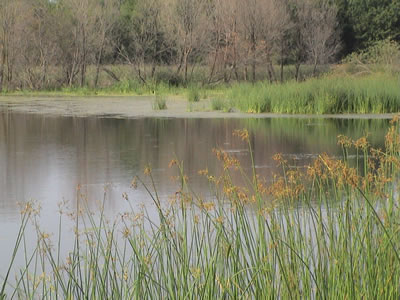
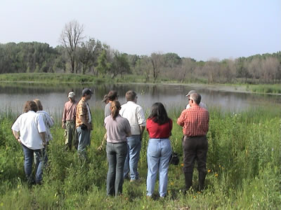
Located in William O’Brien State Park, MN, this DNR-owned site
was formerly a minnow farm established by piping spring water
through a series of constructed ponds. MnDOT, in partnership with
DNR, obliterated the ponds and re-established a trout stream and
associated wet meadow and shallow marsh and sedge meadow
wetlands.
Program Contacts
Sarma Straumanis
Minnesota Department of Transportation
395 John Ireland Boulevard
St. Paul, MN 55155-1899
Phone: 651-284-3788, Fax: 651-284-3754
Email: sarma.straumanis@dot.state.mn.us
Cheryl Martin
Environmental Engineer
FHWA-Minnesota Division
380 Jackson Street, Suite 500
St. Paul, MN 55101
Phone: 651-291-6120, Fax: 651-291-6000
Email: Cheryl.Martin@fhwa.dot.gov
Program History and Philosophy
The Minnesota Department of Transportation established its first wetland mitigation bank in 1987 after two staff members attended a USFWS course on habitat evaluation procedures and determined that banking offered a more cost-effective approach to mitigation. The Rice Lake Mitigation Bank, one of the Minnesota DOT's (MnDOT) largest banking projects, involved the restoration of 670 acres of wetlands in the Staples Drain Area to compensate for impacts from a highway project. The land is owned and managed by the MN Department of Natural Resources. MnDOT invested $314,000 for the four-year restoration effort, which included the purchase of 120 additional acres as buffer. Credits remain available today from the site, which has become an exceptional waterfowl area.
This and future MnDOT mitigation bank projects were implemented under a technical memorandum of agreement between MnDOT, DNR, and USFWS (the COE allowed USFWS to act as its proxy). While the agencies agree that the cooperative effort demonstrated in the Rice Lake Mitigation Bank led to a successful outcome, they discovered early on that confusion over the definition of what constitutes a bank would ultimately create challenges for the program, as would the use of habitat units (versus acreage) as a functional assessment methodology. Assumptions about credits and debits were difficult to make based on habitat values alone. The State's 9.5 million acres of wetlands are extremely diverse, ranging from extensive northern peat lands to small prairie potholes, and including nearly 200,000 acres of wild rice beds. Agency perspectives on how to achieve no net loss of these resources were as diverse as the wetland types themselves.
In the early 1990s the State of Minnesota passed landmark legislation to protect and conserve wetlands. The Wetland Conservation Act of 1991 (WCA), one of the most sweeping protection laws in the country, became effective January 1, 1992, and was fully implemented in 1994. The act is administered by the Minnesota Board of Water and Soil Resources (BWSR), implemented by local government units, and enforced by DNR.
The purpose of WCA is to retain the benefits of wetlands - such as water quality, flood/storm water retention, public recreation, commercial uses, fish, wildlife and native plant habitat - and ultimately to achieve no net loss of wetland quantity, quality, and biological diversity. The act requires anyone proposing to drain, fill, or excavate a wetland to first try to avoid disturbing the wetland; if this is not possible, to minimize any impacts; and finally, to replace any lost wetland acres, functions, and values.
The primary benefit of WCA is two-fold: (1) it defines wetlands as a publicly valued resource of critical importance to the State, and (2) it establishes a comprehensive, statewide approach to wetland conservation. A major challenge soon surfaced, however, involving implementation of the Act at the local level. Many local transportation authorities (cities, counties, townships) lacked the resources and expertise needed to implement the Act's wetland replacement (mitigation) requirement, and in 1996 additional legislation was passed requiring BWSR to implement local wetland mitigation projects for local transportation agencies using State funding.
BWSR's entry into the wetland mitigation development market created an unanticipated problem for MnDOT, who found itself competing with BWSR for the acquisition of mitigation sites. While private banks existed at the time, and continue to emerge in the State under BWSR's guidance, the credits available often did not meet MnDOT's needs in terms of wetland type, quality, or location. As a result, private banking has not been a viable alternative for MnDOT, which meets 90 percent of its mitigation needs through single-user mitigation sites.
Furthermore, great disparities in land costs and associated tax rates exist in Minnesota. It is not unusual to pay $4,000/acre in one part of the State and $43,000/acre in another. Land costs drove both MnDOT and BWSR to lean heavily on the acquisition of conservation easements on land for bank sites, rather than fee title acquisition. BWSR cannot acquire or own land, but it can negotiate conservation easements, and its experience acquiring easements for incentive-based conservation allows it to do so more effectively than MnDOT. Since the enactment of WCA, BWSR has worked cooperatively with State and Federal agencies to successfully restore more than 50,000 wetland acres through both incentives-based and regulatory-driven restoration projects.
For MnDOT it became clear that two independent, statewide wetland mitigation initiatives would complicate rather than facilitate achieving the objectives of WCA. As a result, MnDOT is now in the midst of a major transition, as it moves to turn over its wetland mitigation program administratively to BWSR. The new memorandum of agreement for the Minnesota Wetland Mitigation Banking Cooperative for Public Roads (www.bwsr.state.mn.us) was five years in the making and signed in the late summer of 2005. Perhaps the most challenging aspect of this transition has been attempting to harmonize the Federal 404 and WCA requirements.
One example is bank service areas. The COE identifies eight service areas based on watershed area. However, WCA divides Minnesota into three large regions and identifies service areas based on percentage of historical wetlands remaining. The regions are classified as follows: greater than 80 percent wetlands remaining, 50-80 percent, and less than 50 percent of existing historical wetland drainage base. The less than 50 percent of historical wetlands remaining region requires more mitigation for impacts than the 80 percent historical wetlands region. The spatial restrictions to mitigation are such that three WCA service areas cannot be crossed. Discussions are underway to attempt to reconcile the WCA approach and the COE approach.
Minnesota is seeking to establish mitigation sites not only to serve all geographic areas but also specific wetland types within those the geographic areas. Minnesota pools all the wetland credits available within the State and then separates them into credit by wetland types. Currently, not all regions have in-kind replacement mitigation sites. MnDOT can use credits from a bank site outside of the geographic region if no in-kind bank is available.
Minnesota is attempting to focus mitigation efforts where needed, particularly in the areas with the highest historical loss of wetlands rather than just within the designated region or within the watershed.
In addition to service areas, management and oversight of the mitigation sites needs to be resolved between COE and WCA. Technical evaluation panels (TEPs) are required under WCA. The TEP functions like an MBRT. With the TEP, however, BWSR is the lead, while COE is a non-voting member. With the MBRT, COE is the lead. COE has generally concurred with the TEP, although a process for resolving any future disputes that may arise needs to be determined.
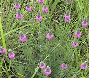
Purple prairie clover is a native legume common
in upland plantings.
Under the new agreement, MnDOT will transfer funds to BWSR to create wetlands and a bank of wetland credits from which MnDOT can draw for future MnDOT projects with wetland impacts. This is similar to the process that North Carolina DOT uses with the Ecosystem Enhancement Program. For the period 2006 through 2011, MnDOT will make regular payments to BWSR of up to $1 million per fiscal year ($5 million total). These monies will be used by BWSR to acquire property or develop wetlands that qualify for deposit of corresponding credits, which will be pooled and stored for use in the MnDOT Road Replacement Account. Also on an annual basis, MnDOT will provide to BWSR a three-year projection of the number of credits that will be needed to fulfill its compensatory wetland mitigation requirements. That figure will be the basis of BWSR's credit development activities. Like North Carolina DOT, MnDOT anticipates an initial learning curve as it refines the process for making these projections as close to target as possible.
Most of MnDOT's existing wetland mitigation banks are currently being transferred to BWSR bank accounts, along with any credits still tied to the bank sites. Although the new banking agreement has not yet been signed, a MnDOT/BWSR/DNR cooperative has already secured and restored an 1,100-acre prairie area with more than 100 separate wetland basins in northwest Minnesota, considered a prized site of significant ecological diversity. The site is located within a few miles of a 50,000-acre property currently being restored by The Nature Conservancy. The MnDOT site contains several species of rare birds and orchids. The Audubon Society and TNC have helped to promote public interest in the mitigation site.
The site is not yet tied to a transportation project; it is considered true advance mitigation (which TEA-21 provides for). DNR and BWSR remain responsible for any site management issues during the five-year bank monitoring period. After that, the Minnesota DNR has agreed to undertake long-term management responsibility for the site as the Wingdahl Wildlife Management Area. The Nature Conservancy's nearby project office has indicated a willingness to assist BWSR and DNR in burning the site because proper management of this site will further the goals TNC has set for its nearby project. Although TNC would not be allowed to directly fund any part of the actual restoration for bank credits, bartering for services may be the a prudent solution to securing services like burning until DNR assumes full management responsibility for the site after monitoring is completed.
Site Descriptions and Operations
MnDOT has established approximately 20 wetland mitigation bank sites throughout the State. BWSR has many additional bank sites that it administers and has calculated that approximately 250 to 400 acres of wetlands are drained or filled each year by WCA-regulated projects, of which 60 to 70 acres are attributable to MnDOT projects.
One of the hallmarks of MnDOT's restoration initiatives is the department's expert use of native prairie and sedge meadow seed mixes. MnDOT has invested generous research dollars to determine the best approaches for cultivating native prairie grasslands and sedge meadows. From carefully scheduled mowing regimens to native seed harvesting and seed cleaning, MnDOT has learned how to achieve a healthy diversity of plant communities on its wetland sites. MnDOT's on-the-ground successes with high diversity seed mixes support recent research that suggests that including 30+ species of plants in a landscape community stifles the spread of invasives and noxious weeds, and thereby also reduces the use of herbicide.
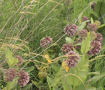
Native milkweed plants attract butterflies.
Another factor contributing to the success of MnDOT's wetland mitigation sites is the rich body of historical data that the University of Minnesota's Center for Urban and Regional Affairs has generated on the location and description of the State's pre-settlement wetlands. The availability of this information allows MnDOT to focus its dollars on true restoration efforts, which have significantly higher success rates than created wetlands (i.e., creating a wetland where one never existed).
The scan team visited the following MnDOT and BWSR mitigation sites:
- Minnow Ponds MnDOT Site (7 acres; 3rd-year restoration underway - credits pending)
Located in William O'Brien State Park, this DNR-owned site was formerly a minnow farm established by piping spring water through a series of constructed ponds. MnDOT, in partnership with DNR, obliterated the ponds and re-established a trout stream and associated wet meadow and shallow marsh and sedge meadow wetlands.
- Woodview Marsh BWSR Site (23 acres; 2nd-year restoration underway - credits pending)
This urban, roadside site was formerly a community garden that became overrun with weeds and Canadian geese. BWSR excavated peat from the site to create both wet meadow and shallow marsh habitat. Because the site is located off the roadside, it could have potential water quality functions, although it is not currently being monitored for this.
- Tiede BWSR Site (200 acres; restoration complete - credits approved)
This site, developed by BWSR and now part of a DNR wildlife management area, was a classic restoration of shallow and deep marsh in three prairie potholes and adjacent upland prairie. All credits expected from the site have been approved by both BWSR and COE, and most remain in the bank for use on future State and local transportation projects in the bank service area.
- Big Dog Slough MnDOT Site (61 acres; restoration complete; credits pending)
This site represents another prairie pothole restoration with some excavation and substantial upland buffer acreage. The regulators have all agreed on the acceptability of wetland and upland acres for deposit in the bank; however, there is disagreement over how much credit to allow for upland buffers. WCA establishes a maximum 1:1 ratio for upland buffers; however, COE is proposing a maximum 4:1 ratio for sites restored to native vegetation like Big Dog. This issue needs to be resolved before the bank can be approved for credits.
Geographic Service Areas. BWSR and COE are still reconciling the WCA and Federal guidelines regarding service areas. WCA identifies greater than 80 percent, 50-80 percent, and less than 50 percent of historical wetland drainage base. And three WCA service areas cannot be crossed. COE has identified eight service areas based on watersheds.
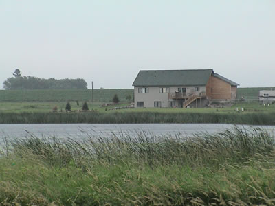
Where new housing development encroaches upon MnDOT
mitigation bank sites, the use of and credit for buffers becomes
an issue of increasing importance.
Functional Assessment Methodology. A functional assessment methodology and performance standards are still being determined for the new agreement, although wetland type and the Cowardin classification system have been used. It is expected that the agreement will move from counting purely acreage of various wetland and upland types towards establishing qualitative currency for credits. DNR, BWSR, and COE want to address credits for the purchase and management of buffers more carefully. As new housing starts to creep closer to some of MnDOT's mitigation sites, buffers are becoming more critical. Currently, the program gives credit for upland buffers (public value credit), but only above the 1:1 replacement ratio. In urban areas, a 25-foot minimum is required and in rural areas, a 50-foot minimum is required for wetland mitigation banks. There is ongoing discussion concerning buffer widths, and buffers remain a controversial issue in Minnesota. Buffers are not regulated resources under the Clean Water Act, and it remains unclear how mitigation for buffers can be required or credited.
Monitoring Protocols. Currently, MnDOT conducts a strict regimen of hydrologic and vegetative monitoring, with perhaps an emphasis on vegetation monitoring, for a five-year period on its mitigation bank sites. Again, BWSR and COE are currently establishing protocols for monitoring under the new agreement.
Accounting Procedures. Under the new agreement, BWSR will handle all accounting related to MnDOT's mitigation bank sites. BWSR is currently working with MnDOT to transfer its current and approved wetland credits into what is being called the MnDOT Road Replacement Account. Credits generated by BWSR through use of MnDOT funds will be placed in the account. Once the Road Replacement Account is officially established and wetland credits have been deposited, MnDOT is authorized to withdraw credits and apply them to satisfy legally required wetlands replacement obligations. This account is a pooled credit bank. MnDOT can draw credits to meet needs that may go beyond a given service area; however, the department cannot withdraw more credits than are actually in the account. If credits are not available in the account, then MnDOT and BWSR can negotiate cash-for-service or service-for-service exchanges.
Maintenance and Management. Invasive plant species pose the greatest maintenance challenge for MnDOT, second only to impacts from new housing constructed near the wildlife refuge properties that support MnDOT wetland mitigation banks. However, MnDOT has made good progress dealing with both issues, the first through research, the second through open discussions with BWSR and COE regarding the importance of buffers.
Long-term management of the wetland mitigation banks sites poses a far greater challenge to MnDOT, as it does for nearly all of the States participating in the scan tour. Although DNR is often tagged as the public agency that will serve as the permanent owner and manager of MnDOT's wetland mitigation sites, many of which are constructed on DNR lands, no money is provided to DNR to support their long-term management. In addition, a number of sites have been developed on private lands where a conservation easement has been purchased, and maintenance responsibility would rest either with the landowner or the agency establishing the bank site. MnDOT and BWSR are currently discussing putting aside five percent of MnDOT's annual contribution to BWSR for the purpose of establishing a maintenance fund that could help subsidize these costs. In addition, MnDOT could provide mowing and burning services in perpetuity.
Urban roadside mitigation sites, such as this one in Minnesota,
could have potential water quality functions, although most
sites are not monitored for this currently.
A larger issue is the fate of a mitigation bank site after 10 to 15 years, when the site restoration and monitoring are complete, all credits have been exhausted, and the site is potentially turned over to a new owner. At this point, who ensures that the ecological integrity of the mitigation site is preserved in perpetuity? COE's enforcement authority expires after 10 years in some cases, although Section 404 requirements may still apply, unless the site is an isolated wetland, in which case it is federally exempt under SWANCC.
MnDOT and BWSR are discussing whether or not a perpetual management clause, including a legal mechanism and financing measure, should be written into the new agreement to address this concern. "Perpetual" management clauses, however, based on use of State or Federal transportation funds, could eventually become an unmanageable problem as funding loads and wetland acreages/projects may increase over time to cumbersome levels. DOTs are not natural resource managers. In mitigating impacts to privately-owned wetlands, it eventually will become necessary to find other managers (private or public) who are self sustaining.
Best Practices and Innovations
- Mitigation bank sites are large in Minnesota, up to several hundred acres. Multiple projects over a long period of time can, therefore, be mitigated per site.
- MnDOT is turning over the wetland bank mitigation program administration functions to BWSR. BWSR has the natural resource technical skills to identify the natural resource needs of Minnesota and plan and design the mitigation areas.
- Minnesota is seeking to establish mitigation sites not only to serve all geographic areas but also of specific wetland types within those the geographic areas. Minnesota pools all the wetland credits available within the State and then separates them into credit by wetland types. Currently, not all regions currently have in-kind replacement mitigation sites. MnDOT can use credits from a bank site outside of the geographic region if no in-kind bank is available.
- Minnesota is attempting to focus mitigation efforts where needed, particularly in the areas with the highest historical loss of wetlands rather than just within the designated service area or within the watershed.
- Minnesota uses one umbrella agreement that covers all mitigation sites.
- MnDOT can receive credit for upland buffers provided that the 1:1 wetland replacement ratio has been met.
- Presently, individual DOT districts within Minnesota have the option of placing existing credits in the statewide collective pot.
- All future sites will be created and managed as a statewide system.
- Preservation as mitigation can be used in extreme circumstances; however, the mitigation must include a restoration component.
Continuing Challenges
- No funding for long-term management of the mitigation sites is available. The State WCA program and COE need to reconcile their processes.
- Performance criteria for the mitigation sites are not well defined. More detailed performance requirements will be developed for future sites.
Back to top

