Nebraska
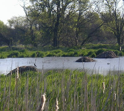
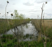
Beaver and muskrat actually help support hydrology on this
11-acre roadside mitigation bank site in Nebraska, which was
formerly an excavation site.
Photo courtesy of Patricia Bacak-Clements, USFWS
Program Contacts
Jason Jurgens
Environmental Permits Unit (EPU) Unit Supervisor
Nebraska Department of Roads
P.O. Box 94759
Lincoln, NE 68509-4759
Phone: 402-479-4418, Fax: 402-479-3629
Email: JasonJurgens@dor.state.ne.us
Ed Kosola
Realty Officer
FHWA-Nebraska Division
100 Centennial Mall North, Room 220
Lincoln, NE 68508-3851
Phone: 402-437-5973, Fax: 402-437-5146
Edward.Kosola@fhwa.dot.gov
Program History and Philosophy
Although the Nebraska Department of Roads (NDOR) has been mitigating for unavoidable wetland impacts since 1990, the department's wetland mitigation banking initiative began in 1997, two years after the issuance of the Federal Mitigation Banking Guidance. NDOR saw banking as an opportunity to move beyond project-by-project mitigation in order to create higher quality wetland resources in a State that has lost more than one million acres of wetlands in the last 200 years (approximately 35 percent of the State's original wetland acreage) primarily due to agriculture. Nebraska has three wetland complexes recognized as being of international importance as migration and breeding habitat for waterfowl and non-game birds: the Rainwater Basin wetlands in south-central and southeastern Nebraska, the Big Bend reach of the Platte River directly north of the Rainwater Basin, and the Sandhills wetlands in north-central and northwestern Nebraska. (9)
Nebraska is a "land rights State" (i.e., State and Federal lands acquisition is restricted in favor of private property rights), and this also contributed to NDOR's decision to adopt banking as a preferred mitigation approach. Nebraska actively seeks to minimize Federal involvement in the NDOR program by not taking Federal funds for mitigation. Moreover, NDOR uses eminent domain law to procure mitigation sites when necessary, but tries to avoid using it for mitigation bank sites if possible. In 1995 the Nebraska State Legislature passed a Highway Bridge Law that included a provision stating that NDOR could not acquire more than 150 percent of the lands needed to meet its six-year transportation plan, including lands for mitigation.
Given these factors, NDOR decided that wetland banking, conducted in cooperation with property owners who voluntarily sell private lands for mitigation needs, would be a more prudent approach. Accordingly, many of the mitigation sites comprising NDOR's bank program are created from either borrow pits or excavation sites from former road projects, or farmlands or prior converted croplands. Some of the sites have been re-acquired through reversionary clauses included in title transfers between NDOR and the Nebraska Game and Parks Department. The NRCS has also assisted NDOR with locating sites, particularly on agricultural lands.
A MBRT was formed, and the first banking instrument was developed in June 1997; however, the language was considered ultimately too vague for proper execution of some of the planning tasks associated with establishing a bank site; therefore, in 1998 the COE-Omaha District drafted supplemental guidance for the banking instrument. The supplemental guidance included clarification on the following key issues: buffer requirements, how to evaluate potential bank sites, guidelines for in-kind mitigation of forested wetlands, baseline information for bank site plans, and credit determination. Two noteworthy items came out of the supplemental guidance. Credit ratios were established for buffers prescribed by the MBRT (0.25 per successful acre established), although it was noted that determination of buffer credits may change upon the adoption of a functional assessment method. In addition, a cultural resource evaluation and coordination provision was added to the list of baseline information required in the site plan.
For nearly a decade, NDOR and the MBRT have successfully advanced the concept of wetland banking in the State, and the wetland resources developed through the program have become particularly well suited as habitat for waterfowl and migratory birds. Through the years, NDOR bank sites have increased in size from 10- and 20-acre creation sites to 640-acre restoration sites. NDOR has also been recognized for developing some simple but innovative mitigation techniques, such as using goats to remove cedars, cottonwoods, and other woody invasive species on creation and/or disturbed soil restoration sites (e.g., farmed wetland or prior converted wetland sites).
Currently, NDOR is undergoing a major shift in its wetland banking program related to geographic service area boundaries. The 1997/1998 banking instrument states that mitigation banks should be established within each physiographic region of the State, generally the major land resource areas (MLRAs), of which there are 13 in Nebraska. Several bank GSAs are limited to a portion of an MRLA, although NDOR has been able to debit these banks for project impacts occurring outside of the designated GSA at increased ratios. The COE-Omaha District, following proposed national guidance forwarding a watershed-based approach to assessing impacts and implementing mitigation, is implementing a shift from MLRAs to banks based on hydrologic unit areas, with the base area being a HUC-8 boundary. NDOR believes that such a shift will limit its mitigation options and is satisfied with the current arrangement with the MLRAs.
From NDOR's perspective, adopting a HUC-8 approach for its banking program is neither a practical nor cost-effective solution, particularly when only one road project or only a portion of a project may fall within many of those areas. Likewise, many of NDOR's projects cross several HUC-8 watershed boundaries. NDOR expects that strictly limiting bank GSAs to HUC-8 watersheds would return its compensatory wetland mitigation program to on-site mitigation and the abandonment of banking as a mitigation approach.
While both NDOR and the COE-Omaha District agree that a watershed approach is beneficial, how to transition to that approach remains an issue of concern. Some of the key questions include the following:
- Is HUC-8 the most reasonable watershed approach for Nebraska?
- Is there ecological justification for using a larger service area in all or some parts of the State?
- How would shifting to HUC-8 affect the size and quality of the bank sites?
- What kind of functional assessment method would need to be adopted?
- Would the costs associated with shifting to HUC-8 necessitate a return to on-site mitigation of wetland impacts for NDOR road projects?
- What would be the timetable established for a transition phase, and what kind of interim guidance should be developed to facilitate a transition?
Other States are already using HUC-8, HUC-11, or HUC-14 service areas. The extent of integration in drainage patterns is a significant factor in determining services areas, as well as population and road density. Nebraska's discussions are just beginning, and the future of banking for NDOR will depend upon the extent to which the MBRT can facilitate a flexible transition phase and harmonize the new guidance with the COE's current guidance. In a recent discussion with the COE and MBRT, NDOR noted that the door has been opened to considering larger GSAs than the HUC-8, especially in light of the State's very low road and population densities. A larger GSA, however, would have to be justified on a case-by-case basis and would still need to involve some element tying it to a watershed approach. The MBRT points out that this would be an exception for all linear transportation related banks, not just for NDOR.
Site Descriptions and Operations
To date, NDOR has developed 18 individual bank sites on a total of 563 developed wetland acres. Many of these sites are considered "creation" sites, which is unique to Nebraska whose original wetlands have been degraded or destroyed to such an extent over the last 200 years that very few opportunities exist for true preservation or restoration. As a result, the mitigation sites are usually situated on borrow pits, farmlands, or prior converted croplands.
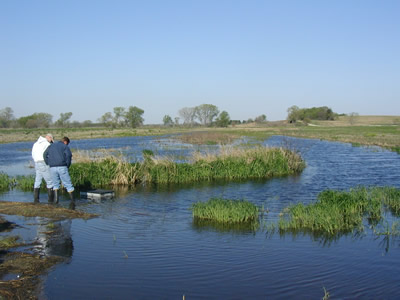
Rock Creek mitigation bank was formerly row crops. The
freshwater and saline wetland restoration site is helping to
provide habitat for the Salt Creek tiger beetle, which is listed
as endangered at the State level.
Photo courtesy of Patricia Bacak-Clements, USFWS
On average, NDOR projects have impacted approximately 32 acres of wetlands per year between 1997 and 2004. Federal transportation enhancement funds were used for the initial establishment of some of the early wetland banks and then repaid when credits were taken out of the banks. No Federal dollars are used currently for establishing NDOR banks. The mitigation is funded out of individual construction projects. While a handful of private banks exist in Nebraska, NDOR has not purchased credits from any of them, and the credits generated by NDOR's bank sites are used exclusively by NDOR.
The scan tour included field visits of the following mitigation sites:
- Waverly Interchange Wetland Bank (14.64 acres; 7.81 acres certified)
Located in the 106 Nebraska and Kansas Loess Drift Hills physiographic region, this wetland was created by excavation and seeded with wetland species. The site is dominated by vegetation that is FACL and OBL. Typical wetland fauna are using the site for feeding, loafing, and reproduction. Soils show low chroma, gleying, and oxidized rhizospheres.
- Ceresco South Wetland Bank (11.21 acres; 9.7 acres certified)
Located in the 106 Nebraska and Kansas Loess Drift Hills physiographic region, this wetland was created by excavation, and the site was in row crops before construction. The site includes a well-established upland buffer. Typical wetland fauna are using the site for feeding, loafing, and reproduction. Soils show low chroma, gleying, and oxidized rhizospheres.
- Rock Creek Wetland Bank (96.74 acres; monitoring underway)
This bank site is a restoration of freshwater and saline wetlands. The bank serves the Eastern Saline Wetlands physiographic region, and freshwater areas of the site will serve the 106 Nebraska and Kansas Loess Drift Hills physiographic region. Most of the site was in row crops. Restoration was achieved by plugging two large erosional headcuts that were draining the wetlands. The site was seeded with a highly diverse mixture for uplands and wetlands. Hydrophytic saline vegetation dominates some of the wetland areas, while others are dominated by freshwater wetland vegetation. The upland areas are still developing desired vegetation. Typical wetland fauna are present, and hydric soils for the site include Colo silty clay loam, Kennebec silt loam, and Salmo silty clay loam.
- West Point Wetland Bank (120.01 acres; monitoring underway; full certification expected in spring 2006)
Located in the 102B Loess Uplands and Till Plains Physiographic Region, this wetland was restored by plugging existing surface drainage ditches. The wetland is dominated by FACW and OBL vegetation. Flora and fauna are consistent with that of other wet meadows. Hydric soils include Lamo silty clay loam.
Geographic Service Areas. Since 1997 the service area boundaries for NDOR's bank program have been defined by physiographic regions, or MLRAs, of which there are 13 in the State. The COE-Omaha District Office is currently recommending a shift to a watershed approach at the HUC-8 (i.e., stream) level, of which there are 80 in the State. This presents significant financial, administrative, operational, and long-term management concerns for NDOR, which are currently being evaluated by the MBRT in coordination with NDOR and the COE-Omaha District. No further bank sites are being pursued by NDOR until the new guidance is developed.
 |
 |
 |
| Documenting species occurrences offers a better gauge of wetland success, according to NDOR biologists who use the Releve field evaluation method as part of their site monitoring plan. |
Functional Assessment Methodology. Currently, NDOR does not employ a standard functional assessment methodology, but rather uses the Cowardin wetland classification system with acres as the currency. Site plans for each mitigation bank site list ratios for created, restored, enhanced, and preserved wetland acres. Credit certification must meet the criteria found in the COE's 1987 Wetland Delineation Manual. Current ratios are 1.5:1 for restoration, 4:1 for enhancement, 2:1 for creation (establishment), 10:1 for preservation, and 4:1 for buffer. Note: these are the new credit ratios established in recent Omaha district guidance(11). Credits for buffers apply only for buffers prescribed by the MBRT, and they must be 50-feet wide and continuous. Credits can be released after three years of monitoring if the success criteria are demonstrated (seven years for forested wetland systems). Invasive species cannot make up more than 10 percent in the third growing season after construction is complete. NDOR is currently receiving training in functional assessment methods and has invited the COE-Omaha District and other agencies to participate. It is believed that if a HUC-8 service area boundary is adopted, then a functional assessment methodology will need to be employed for accurate assessment of wetland functions and credit determinations.
Monitoring Protocols. NDOR's 18 bank sites are maintained by two experienced in-house biologists. Due to limited staff resources, the biologists have implemented a rapid assessment field evaluation method, called the Releve Method, as part of the monitoring plan. The Releve Method, a transect-free method, allows for documenting species composition within a sample community of each wetland type (e.g., PEMA, PEMC, etc.) located in a wetland bank. The evaluator walks the sample site and lists all species encountered; assigns a value to the percent cover of the species identified; notes water depth, aquatic and terrestrial wildlife within the sample; and takes photos. It is believed that documenting species occurrences offers a better gauge of wetland success. Monitoring reports are provided annually to the MBRT.
NDOR currently tracks two specific performance measures: (1) measurement of wetland acres filled versus wetland acres replaced, restored, created, or preserved; and (2) measurement of acres of wetland habitat developed above and beyond the past and present project replacement needs (a measure of temporal gain).
Accounting Procedures. NDOR applies to the COE for certification of available credits from each bank site. The agreed upon credits are then entered into the banking ledger maintained for each site. The ledger reflects the impact site by NDOR project name and COE permit number; the impacted acreage and certified credits, categorized by the Cowardin classification (or other descriptors as specified by the site plan); and the compensation ratio applied for each withdrawal. Credit withdrawals must be approved by the COE-Omaha District prior to their utilization by NDOR. NDOR also records all debits in the ledger. An annual copy of the ledger is provided to the MBRT chair each year a bank is in operation.
Maintenance and Management. In general, NDOR's bank sites have maintained sufficient hydrology in spite of drought conditions in the past growing season. Due to the drought, NDOR's two rainwater basin wetland sites are very dry; this could also be said for many of the natural rainwater basin sites. The Missouri River bank site (Lincoln Bend, designed as a backwater flooding site) is also struggling due to reduced river flows resulting from the drought.
Finding qualified seed contractors has been a persistent problem for NDOR, and in some cases the biologists have had to remove and replant poor seed stock provided by contractors. Mowing, prescribed burns, and periodic use of goats are some of the techniques utilized to manage vegetation growth. Managing vegetation growth is becoming a more critical management problem, in fact, as drought conditions persist.
Overall, NDOR has observed clear differences between its restoration and creation sites. Restored wetlands have a more rapid and diverse vegetative response, and often a greater variety of wetland types. Created wetlands represent more of a management problem for the control of woody invasive species; whereas, restorations typically do not. The soil profile and seed bank are present at restoration sites; whereas, created sites typically entail massive soil moving and disturbance, resulting in sterile subsoil. Unless organic matter with topsoil is introduced, success is difficult. For example, NDOR has achieved much success with stockpiling the hydric soils from the impact sites, mixing these soils with topsoil, and re-spreading the mixture onto the creation site. Small created sites along projects may fulfill acreage replacement requirements, but more quickly change to woody vegetation, Typha, or Phalaris-dominated sites than do restored sites.
NDOR is currently in a dialogue with the NE Game and Parks Department about options for the long-term management and protection of NDOR's wetland bank sites. A compromising factor is the size of NDOR's bank sites. Game and Parks is not interested in assuming long-term management and financial responsibility for a network of 10-acre sites scattered along the edges of roadsides. They would, however, be interested in larger acreage sites that might hold more value especially with regard to public use and recreation. Finding ways to protect a vast network of small wetland bank sites for the long term will continue to be a key point of discussion.
Best Practices and Innovations
- NDOR seeks to partner with private property owners to either voluntarily sell their land or establish conservation easements for NDOR's mitigation needs. Nebraska is a lands rights State, and NDOR is restricted to the amount of land it can legally acquire. Public/private partnerships can ensure that the sufficient and necessary amount of land is obtained for mitigation purposes.
- Credit is given by the MBRT for upland buffers at 0.25 credit per acre of successful buffer established.
- NDOR has determined that restoration sites result in quicker and more diverse vegetation community development than creation sites.
Continuing Challenges
- The MBRT does not meet often enough to facilitate effective communication and timely decision making about bank site proposals and issues of concern.
- The COE-Omaha District proposal to limit service areas to HUC-8 or HUC-6 is perceived by NDOR as potentially jeopardizing the success of its wetland banks and their usefulness.
- The mitigation sites are constructed from State construction funds. Federal funds are not used to establish new sites within the banking system. No new sites are under development as discussions are ongoing with the COE regarding GSAs.
Back to top

