CALIFORNIA DEPARTMENT OF TRANSPORTATION
Cultural Resources Right-of-Way Database
Program Description

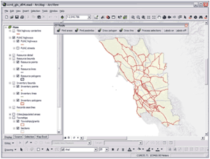
Screenshot of Caltrans right-of-way database.
(Source: California Department of Transportation.)
Program Benefits
- Provides an inventory of properties within the State’s rural ROWs.
- Provides easy access to historic preservation information.
- Provides instant historic preservation information for emergency projects.
- Assists in advance planning for future projects.
- Serves as a tool for effective management and stewardship of historic properties in California DOT’s ROW.
Individual California Department of Transportation (Caltrans) district offices obtained Transportation Enhancement (TE) grants to create inventories of archaeological resources within the rights-of-way (ROW) of State rural highways. Funding was obtained under the TE program’s “Archaeological Planning and Research” category to create Access and Geographic Information Systems (GIS) databases to manage archaeological inventory data. Areas of previous cultural resource surveys and projects within the State Transportation Improvement Plan (STIP) and the State Highway Operation Protection Program (SHOPP), at the time of the TE grant awards, were excluded from these inventories. Though most of the databases are inventories of archaeological sites, some districts have data layers on the historic built environment, ethnographic information, and geomorphological data. Reports, archaeological site forms, and other management documentation also are stored in the databases in PDF form. In addition, some databases include digitized historic maps. These databases serve as a cultural resource portal for information on resources within Caltrans’ ROW.
Setting Up the Program
Program Elements
- Historic Preservation
in Transportation Planning
- Historic Preservation in Early
Project Development
- Geographic Information Systems
- Historic Property Database
In the late 1990s, the Cultural Studies Office staff at Caltrans headquarters, together with staff in Districts 2, 5, and 9, successfully secured TE funds for each of these districts. The first district to receive a TE grant collected cultural resource data on their rural ROW, and had a consultant develop the shell of a desk-top database for the district office. This shell was the foundation for the databases developed by subsequent district offices.
The first step in developing a district’s database involved a records search at the local Information Center (independent offices that maintain the State’s current cultural resource inventory data). Existing data from the centers were entered into the district’s system. Next, the district conducted (usually through the use of consultants) a physical survey of the rural ROW covered by their TE grant, recording newly identified historic properties and updating existing records for known properties. All property locations were recorded using GPS. These GPS data were then added to the district’s database.
To date, Districts 2, 3, 4, 5, 6, 7, 9, 10, and 11 have operational databases (District 8’s is in progress). Each district contracted with a consultant to develop the databases. This work is overseen by a District Data Steward, who is a cultural resource management professional.
Challenges Encountered
In the early 1990s, the Department’s GIS priorities focused on engineering. Including environmental issues within a GIS was not a high priority. There also was Departmental resistance to the use of TE funds for developing the district cultural resource databases. Once the program was in place and running, however, Caltrans managers could clearly see the utility of the databases, and other districts wanted to participate in the program.
Another challenge was the time it took for the districts to deal with the unsorted paper records at the local Information Centers. This effort took much more time than anticipated.
Program Maintenance

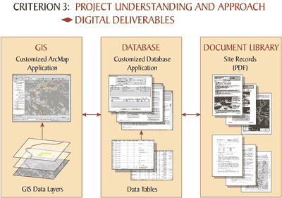
Graphic showing relationship between documents, data applications, and GIS
digital deliverables in Caltrans right-of-way database.
(Source: California Department of Transportation.)
Some changes have been made to the program since its creation, such as simplifying the user interface. These included, for example, software modifications and other upgrades. Currently, the system contains site forms, reports, communications, and other documents that are available electronically. Caltrans intends to add a collections management module to the databases in order to track where collections are housed, as well as records on Native American Graves Protection and Repatriation Act compliance.
Caltrans is working to move all of the district databases into an Enterprise system housed at the Caltrans headquarters office in Sacramento. Currently, each district has its own portal. Changing the organization of the system has been difficult to navigate due to State information technology (IT) mandates and requirements, but the Department is moving forward on this consolidation effort. Consolidating the system at a single location is needed to enhance control and maintenance. It also will enable internal on-line system access that complies with IT best practices.
The program was initially started through TE grants. Now, however, maintaining and updating the system is included as a line item in the budget of each project within an existing Caltrans right-of-way requiring an environmental review.
Maintenance is carried out by a point of contact within each district. For some district staff this is a half-time job whereas for others it requires far less time to do data entry, depending on the scale and number of projects. Some project information comes into the district electronically and Caltrans is gradually moving toward making this electronic information transfer a requirement.
One of the current challenges faced by the program relates to Caltrans’ archaeological collections. Senior Caltrans historic preservation staff is continuing to retire, and as a result, the Department is losing its corporate memory about these collections. This is the reason behind the creation of the program’s collections management module.
Another challenge is working with the State’s IT bureaucracy.
Critical Factors for a Successful Program
The program has succeeded because it had a champion to market the program internally to all levels of project management.
Caltrans had some false starts in the beginning because of the decentralized nature of the program. What worked for one district did not work for others and this resulted in inconsistencies within the program. If Caltrans were starting over, it would centralize the program from the beginning in order to promote long-term management and consistency.
June 1, 2012

