MINNESOTA DEPARTMENT OF TRANSPORTATION
MnModel – Archaeological Site Predictive Model
Program Description

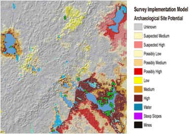
Survey implementation model showing high potential areas (reds and dark browns)
around modern lakes. Green dots are sites used to develop the model.
(Source: Minnesota Department of Transportation.)
Program Benefits
- Use of the archaeological predictive model enables MnDOT to anticipate the effects of projects on archaeological resources early in the project development process, and to estimate the potential costs of mitigation if avoidance of significant archaeological sites is not possible. These estimates can then be built into project funding and schedules.
- The model facilitates early archaeological sensitivity identification and impact evaluations of multiple project alternatives.
- The model can be used to predetermine the level of effort required to identify archaeological sites within proposed project alternatives.
- After applying the model to projects statewide for two years, the resulting project cost savings allowed MnDOT to recover the costs of model development. In addition, project delivery time improved by 30 percent as a result of the model’s effectiveness and other streamlining measures.
The Minnesota Department of Transportation (MnDOT) began developing an archaeological site predictive model, referred to as “MnModel,” in 1995. There were two subsequent refinements of the model by 1998. MnModel uses Geographic Information System (GIS) modeling and statistical analysis to predict the likelihood of finding pre-1837 archaeological properties anywhere within the State. A separate landscape suitability model includes information on the potential for deeply buried archaeological sites within various depositional environments and landforms within the State’s major river valleys and on the Anoka Sand Plain. MnModel is used by the DOT’s Cultural Resources staff during Section 106 reviews to assess potential impacts to archaeological resources.
The current model refinement began in 2000 with a major effort to acquire higher resolution data and to perform extensive quality control on the archaeological database. Additional geomorphic data were mapped in 2002 and 2009. MnDOT updated the program’s statistical methods in 2007 to include more types of statistical analysis and to automate additional procedures. In 2008, MnDOT developed a GIS model to map probable locations of historic and prehistoric water bodies based on soil properties, geomorphology, and historic maps. In 2012, MnDOT will use a mix of Federal Highway Administration (FHWA) and State funds to digitize boundaries of archaeological sites and surveys, to acquire a high-resolution (10 meter) digital elevation model of the State, and to digitize historic General Land Survey Office plat maps. These efforts, which will continue for the next several years, will complete the data needed to update the model. The current refinement effort will exclude contact era sites (1650-1837) and focus exclusively on locations of precontact sites. The refined model will be shared with Federal and state agencies, Tribes, and qualified archaeologists via a web application, now under development.
Setting Up the Program
MnDOT applied for and received $5 million in 1995 from the Transportation Enhancement (TE) program, and contracted with a private firm to develop the model. The modeling team started with one county and, as methods were refined, expanded the modeling effort to groups of counties, then regions until the entire State was covered. This phase of the program took three years.
Since the modeling effort was to be awarded to a consultant, the proposed program had to first go through MnDOT’s internal project review process. The MnDOT archaeologist had to satisfy the reviewing committee that the modeling program would deliver tangible benefits, expediting transportation project delivery and reducing project costs. Once approved, the program began with construction of the model, followed by testing and refinement.
Challenges Encountered
Program Elements
- Historic Preservation in Early
Project Development
- Geographic Information Systems
- Historic Property Database
- ID and Mapping of Archaeological Sensitivity
The biggest initial challenge was the availability of good quality, high-resolution GIS data. In 1995, the environmental data needed to build the model were just becoming available in digital formats and had not been subjected to rigorous quality control and correction. Distortions in the elevation data were ‘smoothed’ using GIS algorithms. In addition, data available for surface water features reflected modern, not historic or prehistoric, hydrography. Only small corrections were possible in the initial project; however, modeling historic hydrography through use of a variety of GIS data sources, is a key component of the current refinement effort.
The modeling team detected a bias in archaeological survey data. Archaeologists tended to look in areas where they expected to find sites, skewing the model results.
Extensive quality control after completion of earlier refinements indicated a number of errors in UTM coordinates used to map sites. Coordinates may have been incorrectly interpreted from USGS topographic maps or may have been incorrectly entered into the digital database. The problem is being resolved under the current refinement effort by digitizing site boundaries.
Program Maintenance

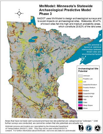
Map showing statewide archaeological probability.
(Source: Minnesota Department of Transportation.)
After the consultant project was completed, a member of the modeling team was hired by MnDOT to maintain MnModel and direct future updates. Until 2012, maintenance of the project was funded primarily with State resources. Most of this work has been done in-house, with consultant projects focused on geomorphic mapping and procedural enhancements. The primary challenge has been resolving funding and scheduling conflicts between the needs of the modeling program and other MnDOT projects. Funding for the current refinement comes from FHWA, with a 20 percent State match. A commitment of staff time has been made available within MnDOT so that the model can be updated internally.
Critical Factors for a Successful Program
Buy-in from users and agencies was critical to the success of the project. The DOT’s Cultural Resources Unit’s archaeologists and historians have found the model very valuable for Section 106 reviews, and MnDOT has continued to be supportive of the project as a streamlining tool.
It is important to understand which variables (archaeological data, environmental data, modeling region boundaries, etc.) most influence the reliability and confidence of the model. After three iterations of the model, staff gained a better idea of what was needed to improve the model’s reliability to identify areas of archaeological sensitivity.
Accurate digital archaeological site and survey locations (preferably polygons) are a key component for improving the model’s performance. Moreover, digital survey data should indicate which parts of a project’s area were actually surveyed and which were not surveyed because of disturbance, steep slopes, or other reasons.
June 1, 2012

