Stormwater Best Management Practices in an Ultra-Urban Setting: Selection and Monitoring
4.3 Monitoring Program Planning Phase
Program planning represents a critical phase of monitoring program development and implementation. It establishes the overall framework with well-defined criteria and the specifications required for designing an effective sampling plan and associated laboratory analyses and data quality control procedures. Figure 38 summarizes the components evaluated during the program planning phase and provides a set of key considerations and monitoring planning decisions. These key components include:
- Well-defined management goals and a description of technical questions to be answered by the program.
- Understanding of the physical characteristics of the site, as well as the function and design considerations of the targeted BMP.
- Identification of the available resources and constraints, including staff and funding availability and constraints such as time frame, access and permits, and staff allocation and expertise. Under this component, staff roles and responsibilities in the program are defined.
- Development of clear monitoring objectives based on the results of previous components, including guidelines for selecting the constituents to monitor, number of monitoring locations, and data quality objectives.
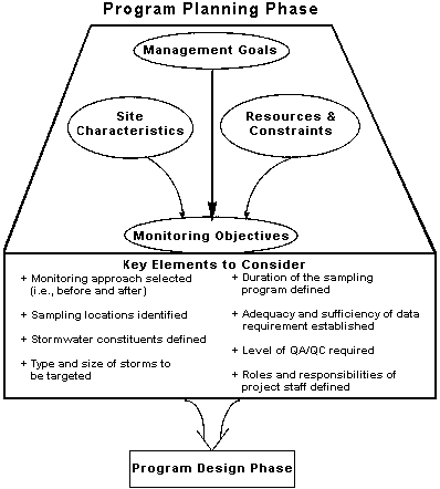
A successful program planning phase relies on (1) collecting and properly processing all programmatic and technical information relevant to characterizing the intended use of the data; (2) defining the interrelationships between the various planning components, including management questions to be answered, available resources, and site conditions; and (3) deriving a set of monitoring objectives and guidelines for final design of the program. The interrelationships between the various planning components can be developed through a dynamic and iterative process to optimize the available resources while providing monitoring data to answer multiple questions.
Stormwater management goals are generally broad statements or questions concerning a water quantity or quality issue. Water quality issues related to stormwater runoff can be associated with implementation of BMPs as a means of mitigating potential impacts. Management goals can thus be viewed as questions concerning implementation of the selected BMPs. The goals can be confined to addressing a specific site condition, or a specific type of pollution source, or they can be broad enough to encompass application of BMPs to an entire watershed or region. An adequately designed BMP monitoring program should generate sufficient information to support a variety of management, programmatic, and technical goals. Examples of typical management goals related to monitoring of BMPs, or combinations of BMPs, include:
- Evaluate the ability of a BMP to provide water quality benefits to receiving waters when applied watershed-wide.
- Support integration of a BMP technology or approach into a large-scale program of watershed or stormwater management.
- Determine the ability of a BMP to target and treat specific stormwater constituents in a new setting or as compared to other BMPs.
- Evaluate the feasibility of, or enhanced function of, alternative or innovative BMP designs.
- Demonstrate the ability of a BMP to perform under site-specific land use, physiographic, and climatic conditions.
- Evaluate the ability of a BMP to address specific pollution sources.
- Define the longevity of a BMP and evaluate maintenance requirements.
Although management goals can be stated in the broad perspective of overall stormwater or watershed management, during the planning phase they should be redefined to reflect specific monitoring requirements. Examples of management goals related to monitoring formulated by the Virginia Department of Transportation are shown in the following box.
|
Example of Management Goals
In 1991, a two-phase field study was initiated by the Virginia Department of Transportation to test the pollutant removal efficiency of selected BMPs (Yu et al., 1993, 1994). The Virginia Department of Transportation defined the major goal of the monitoring program as the development of design guidelines for the stormwater best management practices section in its Stormwater Management Manual. Additional goals of the program were to:
- Evaluate the pollutant removal efficiency of a dry pond detention facility.
- Evaluate the pollutant removal efficiency of a grass-lined swale that collects runoff from an urban highway.
|
Characterization is a review and interpretation of the condition of the area draining or hydrologically connected to the monitoring location, the key design features of the BMP to be monitored, and the constituents that may be associated with the upstream land use activities. Characterization develops the information base that supports understanding the BMP systems and setting and ultimately the formulation of specific monitoring objectives. The results of the characterization can be used to help define objectives that target the water quality constituents of concern and their expected concentrations in runoff under various hydrologic (wet-weather) conditions. Checklists of site characteristics that are typically used in supporting the design of a sampling plan or have a significant influence on the site's response to water quantity and quality controls are presented below. These include the following categories of factors influencing or assisting in understanding the site hydrology, site water quality condition, and type and design characteristics of the BMP to be monitored.
Hydrologic Characterization
The purpose of hydrologic characterization of a monitoring site is to (1) review the distribution of storm size and storm frequency on a seasonal and annual basis to help define a hydrologically representative set of storm types and sizes to be sampled, (2) evaluate the local rainfall-runoff relationship to assist in defining the number of samples per storm and the sampling interval, and (3) determine the primary flow and transport mechanisms to better understand the behavior of flow routing within the drainage area and associated flow controls (e.g., swales, pollution prevention, connected imperviousness, slopes). Flow routing can have a significant impact on the fate of water quality constituents, and an understanding of localized flow routing processes can support locating key sampling stations. In addition, hydrologic assessment at the site contributes to identification of potential problems associated with increased stormwater runoff from impervious surfaces and a targeted assessment of the benefits of the BMP.
|
Checklist of Site Characteristics Site Hydrology
- Drainage area
- Rainfall records and statistical analysis of storm characteristics and frequency
- Gaging station records and statistical analysis (for closest downstream gaging station)
- Parameters that influence hydrology:
- percent imperviousness
- percent imperviousness hydrologically connected to storm drainage system
- storm drainage systems, location of outfalls
- soil characteristics
- depth to water table
- topography
- land cover
- land use (existing and future)
- development history
- projected roadway alignment modifications, roadway expansion
|
In an ultra-urban environment, a high percentage of the infiltratible land has been replaced with structures and paved surfaces. The runoff that was naturally retained and infiltrated is now routed directly to downstream water bodies (Brookes, 1988). Some of the direct effects are an increase in the flow volume, higher frequency of medium to high flows, and reduced base flow and groundwater recharge (Nunnally and Keller, 1979). These impacts can tend to increase erosion within stream channels to unacceptable levels. The eroding streams drain wetlands and can destroy both wetland and aquatic habitat, as well as diminish the aesthetic value of the stream and wetland system (Brookes, 1988). Changes in hydrologic regime due to increased imperviousness can be manifested by flooding of roads or structures in the immediate vicinity of the BMP, downstream flooding in areas adjacent to receiving streams, or degradation of stream channels downstream of outfalls. The adjacent box presents a checklist of site characteristics that can influence the hydrologic conditions and provide information to support design of the sampling plan. Analyses that can be used to investigate the hydrology of the site and any potential or existing impacts to downstream water bodies include:
-
Rainfall data from a nearby rain gauge can be used to calculate a storm return interval, or the frequency of specific storm sizes, at the site. Evaluation of the rainfall frequency spectrum can be used to identify criteria for selection of storms for sampling and can be used to determine whether the sampled events are representative of the rainfall regime that normally occurs within the watershed.
-
Downstream gaging station information can be used to produce stage-discharge rating curves as well as a frequency analysis of flow conditions. The rating curves can be used to determine the short-term or long-term shifts normally associated with urbanization. Frequency analysis can be used to determine the peak design storm associated with a specific return interval. This information can be used for evaluation of design storms in critical conditions for evaluation of BMP function.
-
Field reconnaissance can provide qualitative assessment of downstream water bodies for signs of urbanizing effects, such as bank widening, channel down-cutting, or drained wetlands. Review of field data and information gathering supports the identification of specific impacts prior to initiation of monitoring efforts. This baseline evaluation can be used to support a "before and after" assessment of site conditions. Evaluation of site conditions is used in targeting sampling locations and identifying potential problem locations for sampling. For example, sampling sites should not be located in areas where backwater conditions may occur.
-
Drainage area characteristics, such as imperviousness of the site, drainage system design, land use activities, soils, and slopes, can provide valuable insights into the hydrologic response of the system to rainfall events. This information can be used to estimate the quantity of stormwater runoff for various size storms and antecedent conditions (i.e., number of days since previous rainfall or soil moisture conditions). A basic understanding of the runoff characteristics is used to size sampling equipment and select sampling periods (i.e., storm sizes). Direct measurement of runoff at gaging stations or localized sampling points can be used to support monitoring design. In the absence of local data, estimates can be made based on site characteristics. A typical technique for runoff estimation is the Soil Conservation Service TR-20, which estimates runoff based on site imperviousness and use. More sophisticated estimation of runoff characteristics based on drainage area features and storm drainage systems can be performed using computer simulation models. For additional discussion of runoff estimation methods, see Evaluation and Management of Highway Runoff Water Quality (Young et al., 1996).
-
Local studies relevant to the site or data that have been collected nearby should be reviewed if available. In some areas extensive floodplain analyses have been performed, or studies on roadway design might have included runoff estimation for the purpose of culvert and bridge design.
-
Future conditions should also be considered in the hydrologic characterization phase. If drainage area characteristics or land use activities change significantly during the sampling period, the monitoring results may be skewed. Evaluation of future conditions includes consideration of land use zoning and build-out conditions, population or development projections, and roadway alignment or expansion plans.
This investigation will determine the hydrologic condition of the sites, the potential sampling locations, and the potential timing of monitoring efforts based on hydrologic conditions.
Characterization of Site Water Quality
Water quality conditions at the site can be characterized through
- delineation of built-up areas and their connectivity to the transport network;
- identification of land uses, including industrial and commercial facilities and specialized uses that may be hot spots such as gas stations and vehicle storage areas;
- documenting and characterization of land use activities such as chemical applications of nutrients or pesticides on grassed areas, and their rate and timing; and
- identification of any constituent sink areas such as floodplain/wetland areas upstream of the BMP monitoring locations.
The site characterization process is used to define the most likely constituents of concern, their potential magnitude in stormwater runoff, and their most likely removal processes (e.g., settling, biological decay). The following box presents a set of site characteristics that influence land deposition of stormwater quality constituents and washoff, and provides information for the design of monitoring requirements and a sampling plan.
The most direct method of investigating water quality characteristics at a site is to conduct a preliminary site screening through an analysis of a limited set of samples. Short of such screening activity, the review of available information on water quality conditions at the site or at sites with similar characteristics can be accomplished through a combination of site environmental assessment and review of available literature and case studies.
Table 20 presents a summary of potential sources of chemical constituents generally found in highway runoff. Suspended sediment concentrations typically are the highest of any stormwater runoff parameters associated with ultra-urban stormwater runoff (Driscoll and Mangarella, 1990). Sediments having high organic or clay content typically act as a carrier of bacteria, trace metals, and toxicants. Heavy metal concentrations within stormwater runoff are of concern because of their potentially toxic effects on aquatic habitat and drinking water sources.
Table 20. Constituents and Sources in Highway Runoff
| Constituent |
Source |
| Particulate |
Pavement wear, vehicles, atmospheric deposition, maintenance activities |
Nitrogen,
Phosphorus |
Atmospheric deposition and fertilizer application |
| Lead |
Leaded gasoline from auto exhausts and tire wear |
| Zinc |
Tire wear, motor oil, and grease |
| Iron |
Auto body rust, steel highway structures such as bridges and guardrails, and moving engine parts |
| Copper |
Metal plating, bearing and brushing wear, moving engine parts, brake lining wear, fungicides and insecticides |
| Cadmium |
Tire wear and insecticide application |
| Chromium |
Metal plating, moving engine parts, and brake lining wear |
| Nickel |
Diesel fuel and gasoline, lubricating oil, metal plating, bushing wear, brake lining wear, and asphalt paving |
| Manganese |
Moving engine parts |
| Cyanide |
Anti-caking compounds used to keep deicing salts granular |
Sodium,
Calcium,
Chloride |
Deicing salts |
| Sulphates |
Roadway beds, fuel, and deicing salts |
| Petroleum |
Spill, leaks, antifreeze and hydraulic fluids, and asphalt surface leachate |
| Source: Adapted from USEPA, 1993. |
|
Site Water Quality Characteristics
Parameters that influence water quality:
- percent imperviousness
- percent of imperviousness hydrologically connected
- storm drainage systems
- soil characteristics
- depth to water table
- slopes
- land cover
- land use (existing and future)
- specialized land uses ("hot spots" such as gas stations)
- land use activities (i.e., fertilizer application, deicing materials).
Evaluation of water quality conditions in surface water or groundwater (depending on availability):
- monitoring or screening samples collected in the immediate vicinity of the site during site characterization phase
- monitoring in nearby drainage areas
- monitoring in locations in similar regions or settings
- literature values for similar land use conditions
- visible impacts (qualitative) observed during field reconnaissance.
|
Typically, the three heavy metals with the highest concentrations in ultra-urban stormwater runoff are copper, lead, and zinc (Driscoll and Mangarella, 1990). Oil and grease includes a wide variety of different hydrocarbons, including trace organics such as polynuclear aromatic hydrocarbons (PAHs). In general, hydrocarbons tend to adsorb readily to sediments and settle out in the bottoms of rivers, lakes, and estuaries, where they accumulate. In the majority of the monitoring case studies that were evaluated for use in this document, the constituents sampled for were similar to those sampled during NURP (USEPA, 1983 ). In many cases, the list of NURP constituents, although comprehensive, was not targeted to the local conditions or to typical constituent concentrations.
Examples of information and analysis to consider during the site characterization process include:
-
In the absence of localized sampling, downstream water quality monitoring data or data from nearby drainage areas with similar use characteristics can provide a general overview of water quality conditions.
-
Field reconnaissance can provide a qualitative assessment at the site and at downstream water bodies that can support estimation of water quality conditions and potential constituents of concern. Observations of land use activities (i.e., gas stations, parking lots, park areas) can provide indicators of potential constituents available during runoff events.
-
Local studies, reports, or data documenting existing or potential problems related to water quality, biological integrity, or stream stability can provide background information on the water quality conditions.
-
Literature values that characterize constituent loadings by source under similar climatic conditions and land use distribution can be used in the absence of (or as a supplement to) localized monitoring information. An example of typical constituent concentration values in highway runoff reported in the literature is shown in Table 21. The nationally derived literature values shown in Table 21 may vary widely depending on the local climate and soil/slope conditions.
-
Drainage area characteristics and land use activities such as imperviousness of the site, drainage system design, land use activities, soils, and slopes can provide valuable insights into the availability of constituents for washoff during rainfall events or leaching to groundwater systems. This information can be used to estimate the quality of stormwater runoff during various time periods and conditions. Prediction of constituent concentrations or loads can be used to guide in the selection of constituents, type of sample (e.g., dissolved, particulate), and frequency of sampling for the program. Water quality concentration and loadings can be estimated using computer simulation models (e.g., SWMM). Although water quality modeling is not typically performed solely for the purpose of monitoring design, models developed as part of broader objectives can be used to supplement, test, and evaluate monitoring designs. For additional discussion of stormwater quality estimation methods, see USEPA (1992) and Young et al. (1996).
-
Future conditions should also be considered in the water quality characterization phase. If the drainage area characteristics or land use activities change significantly during the sampling period, the monitoring results may be skewed. Evaluation of future conditions includes consideration of land use zoning and build-out conditions, population or development projections, and roadway alignment or expansion plans.
-
Historical land use changes within the watershed or at the site can provide insights into current conditions and form a baseline for future evaluations.
Table 21: Constituents of Highway Runoff, Ranges of Average Values Reported in the Literature
| Constituent |
Concentration
(mg/L unless indicated) |
Load
(kg/ha/year) |
Load
(kg/ha/event) |
| Solids |
| Total |
437 - 1147 |
|
58.2 |
| Dissolved |
356 |
148 |
|
| Suspended |
45 - 798 |
314 - 11,862 |
1.84 - 107.6 |
| Volatile, dissolved |
131 |
|
|
| Volatile, suspended |
4.3 - 79 |
45 - 961 |
.89 - 28.4 |
| Volatile, total |
57 - 242 |
179 - 2518 |
10.5 |
| Metals (totals) |
| Zinc |
.056 - .929 |
.22 - 10.40 |
.004 - .025 |
| Cadmium |
ND - .04 |
.0072 - .037 |
.002 |
| Arsenic |
.058 |
|
|
| Nickel |
.053 |
.07 |
|
| Copper |
.022 - 7.033 |
.03 - 4.67 |
.0063 |
| Iron |
2.429 - 10.3 |
4.37 - 28.81 |
.56 |
| Lead |
.073 - 1.78 |
.08 - 21.2 |
.008 - .22 |
| Chromium |
ND - .04 |
.012 - .1 |
.0031 |
| Magnesium |
1.062 |
|
|
| Mercury, x 10-3 |
3.22 |
.007 |
.0007 |
| Nutrients |
| Ammonia, total as N |
.07 - .22 |
1.03 - 4.6 |
|
| Nitrite, total as N |
.013 - 2.5 |
|
|
| Nitrate, total as N |
.306 - 1.4 |
|
|
| Nitrite + Nitrate |
.15 - 1.636 |
0.8 - 8 |
.078 |
| Organic, total as N |
.965 - 2.3 |
|
|
| TKN |
.335 - 55 |
1.66 - 31.95 |
.17 |
| Nitrogen, total as N |
4.1 |
9.8 |
.02 - .32 |
| Phosphorus, total as P |
.113 - .998 |
.6 - 8.23 |
|
| Miscellaneous |
| Total coliforms organisms/100mL |
570 - 6200 |
|
|
| Fecal coliforms organisms/100mL |
50 - 590 |
|
|
| Sodium |
|
1.95 |
|
| Cloride |
|
4.63 - 1344 |
|
| Total organic carbon |
24 - 77 |
31.3 - 342.1 |
.68 - 2.35 |
| Chemical oxygen demand |
14.7 - 272 |
128 - 3868 |
2.90 - 66.9 |
| Biological oxygen demand (5 day) |
12.7 - 37 |
30.60 - 164 |
.98 |
| Polyaromatic hydrocarbons (PAHs) |
|
.005 - .018 |
|
| Oil and grease |
2.7 - 27 |
4.85 - 767 |
.09 - .16 |
| Source: Barrett, et. al., 1995 |
|
BMP Characterization
- Type of BMP (off-line or on-line)
- BMP surface area (detention/retention type)
- Design storm/storage capacity
- Inlet features
- Presence of overflow structures and characteristics
- Description of the types and designs of outlets
- Primary water quality treatment process
- Localized (in immediate vicinity of BMP) channel type and geomorphology, soils, slopes, depth to water table, proximity to stream system
- Hydraulic response of BMP to hydrologic inputs
- Location of separate inflow/outflow points
- Date installed or retrofitted, planned installation date
- Type and frequency of maintenance activities
- Upstream and downstream site characteristics
- Right-of-way, easements, and required permits
|
BMP Characterization
The purpose of the BMP characterization is to provide an understanding of the setting of the BMP, the BMP features, and the processes governing the fate and transport of constituents within the BMP that result in an overall removal rate under various hydraulic loading conditions. During the BMP characterization, design criteria influencing the primary removal processes should be reviewed and preliminary assessment of each removal process (i.e., settling, adsorption/filtration, biological decay) should be performed, considering the set of targeted constituents. The adjacent box provides a list of key characteristics to be considered when assessing the BMP to be monitored. BMP characterization focuses on gathering relevant information to support development of general guidelines to be used in final design of the monitoring program. An example of BMP characteristics and their relevance to the design of a monitoring program is presented in Table 22. It should be noted, however, that additional site and BMP characteristics are needed to assist in the later data analysis and interpretation phase. An understanding of the primary treatment processes employed by BMPs supports the design of an effective monitoring program. BMP monitoring is an examination of the effectiveness either as a "black box" measuring in and out, a collection of processes within a BMP, or components in a train of BMPs. Monitoring objectives may be defined to include the examination of particular dissolved or adsorbed constituents and selected processes in the system or BMP. The principal fate processes of constituents in stormwater runoff are:
- Adsorption.
- Volatilization.
- Biodegradation.
- Filtration.
- Settling.
- Bioassimilation.
Table 22. Example of BMP Characteristics Relevant to Developing a Monitoring Program
| BMP Characteristics |
Relevance to Monitoring |
Examples/Definitions |
| BMP type |
Type of monitoring
Sample media |
Surface water, groundwater, sediment
Filter media |
| Hydraulic response |
Define frequency and extent of flow bypassing
Sediment resuspension due to high velocities |
Overflow, diversion structures
Unconsolidated depositional areas |
| BMP size (ratio of BMP surface area to drainage area) |
Understanding the flow routing through BMP
Assist in defining sampling intervals and duration during storm events |
|
| Design storm and storage capacity |
Assist in defining sampling intervals and duration during storm events |
Wet pond and wetland systems |
| Outlet control and flow restrictions/diversions |
Define the number and location of sampling stations
Define flow monitoring techniques (weir, theoretical rating curves, direct measurements) |
Single/multiple outlets (overflows, direct sheet flow)
Backwater problems
Outlet blockages |
| Inlet features |
Number and location of inflow inlets |
Ratio of base flow to mean storm flow |
| Primary treatment processes |
Refine sampling constituent list
Define detection limits and QA/QC requirements |
Sedimentation ponds |
| Channel type and geomorphology |
Locating station and sampling points
Secure water sampling intakes and stage sensors |
Natural channel/concrete pipe
Rapid changes in velocity/channel geometry
(unstable stream sections, scouring, deposition)
Backwater problem |
| Upstream pretreatment devices |
Refine sampling constituent list
Define detection limits and QA/QC requirements |
Sediment forebay
Flow spreaders |
Table 23 summarizes the constituent removal processes employed by the various types of BMP categories. For additional discussion of BMP categories and specific design features, refer to Chapter 3. Review of the primary constituent removal mechanisms for the BMP to be monitored can guide selection of the constituents to be monitored in inflow and outflows (i.e., dissolved, adsorbed, transformation products), the type of supplementary monitoring (i.e., filter media, depositional materials), and the timing of the monitoring (i.e., settling, infiltration timing).
Table 23. Primary Constituent Removal Mechanisms in Selected BMP Categories
| Constituent |
Infiltration
Bioretention |
Detention/
Retention/
Wetlands |
Sand Filters |
Vegetated Swales/
Filter Strips |
Water Quality Inlets |
Porous Pavement |
Streetsweeping |
Other Nonstruct. BMPs |
| Heavy Metals |
Adsorption
Filtration |
Adsorp.
Settling |
Settling
Filtration |
Settling
Filtration |
Adsorp.
Settling |
Filtration
Adsorption |
Physical Removal |
Source Control |
| Organics |
Adsorption
Biodeg. |
Adsorp.
Settling
Biodeg.
Volatil. |
Settling
Filtration |
Adsorp. |
Settling |
Filtration
Adsorption |
Physical Removal |
Source Control |
| Nutrients |
Adsorption
Bioassim. |
Bioassim. |
Settling |
Bioassim. |
Settling |
Filtration
Adsorption |
None |
Source Control |
| Solids |
Adsorption |
Adsorp.
Settling |
Settling
Filtration |
Settling
Filtration |
Settling |
Filtration
Adsorption |
Physical Removal |
Source Control |
| Oil & Grease |
Adsorption |
Adsorp.
Settling |
Filtration |
Adsorp. |
Adsorp.
Settling |
Filtration
Adsorption |
None |
Source Control |
| Source: Adapted from Maestri et al., 1988; Scholze et al., 1993. |
A review of resources and constraints is needed to define the scope and timing of implementation of the monitoring program. In this component, the availability of resources, resource distribution options, and constraints in staff time, laboratory resources, or contract funding are defined. The box below presents examples of project resources and constraints.
The definition of funding options and constraints will support definition of specific monitoring objectives and ultimately design of appropriate and cost-effective monitoring techniques. Funding for BMP monitoring should consider the cost for design and installation of the monitoring system, implementation of the monitoring program (sample collection, data analysis and processing, laboratory costs), and evaluation of the monitoring results. The funding evaluation should also consider the time frame and level of staff time required to support monitoring activities throughout the life cycle of the monitoring program. These activities can be supported by combinations of in-house staff, program resources, grants, cooperative funding, or other external funding. Funding can be evaluated in terms of resource options to allow optimizing monitoring design specifications in later phases. Flexibility in resource options may allow tradeoffs between various funding sources and use of staff, cooperative agreements, and external contracting. Typical costs associated with establishment of a BMP monitoring station are shown in Table 24.
Table 24. Typical Costs Associated with Establishment of an Automated BMP Monitoring Station
| Equipment |
Range in Cost ($) |
| Stage (flow) Monitoring |
2,500 - 3,500 |
| Water Sampler |
2,500 - 4,000 |
| Sensors (e.g., rainfall, temp, pH, dissolved oxygen, conductivity) |
300 - 1,500
per sensor |
| Instrument Shelter and Platform |
2,000 - 3,000 |
| Installation and Testing of Equipment |
3,000 - 6,000 |
| Total Costs |
10,300 - 18,000 |
| Source: TetraTech, Inc. (1995 dollars). |
Review of in-house staff capabilities and skills to support monitoring tasks should consider the following:
-
Identify capabilities, staff time available, and options for the monitoring program implementation phase in terms of hours/month.
-
Identify roles of key staff members based on skills such as design, monitoring implementation, QA/QC officer, data analysis and statistics, and data interpretation.
-
Clearly identify constraints in terms of time period, funding or staff time available per period (annual or monthly), staff laboratory costs or capacity including logistical issues (e.g., days lab will receive samples), transportation logistics (distance to sampling location from offices and laboratory), and access permission.
|
Project Resources and Constraints
Monitoring cost
- Design
- Installation
- implementation
Funding sources
- staff time
- grants
- cooperative agreements
Constraints
- staff time
- logistics/climate
- access/transport
- equipment availability
- laboratory receiving times and processing
|
Constraints Related to Site-Specific Conditions
These constraints are identified based on the site characterization process. Review of site constraints should consider:
-
Size of the site for installation of monitoring equipment.
-
Access, rights-of-way, easements for access or permission to access site for monitoring.
-
Permitting requirements for monitoring installation.
-
Access to electrical power if automated equipment is needed.
-
Site safety for sample collection and processing.
-
Access to sampling locations or other special logistical constraints due to climate.
The vegetated buffer case study presented in the adjacent box shows how resources such as time and money and constraints associated with physical site conditions can affect the monitoring design and the results of the monitoring program.
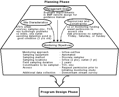
The final element of the planning phase is specification of monitoring objectives. Monitoring objectives are formulated from the results of the interaction between management goals, site characterization, and identification of resources and constraints. Within the framework of the monitoring program design process, objectives also serve as the link between the planning phase and the design phase, as shown in Figure 39.
|
Vegetated Buffer Study
A field study to determine the influence of vegetation composition, buffer width, and infiltration rate on the effectiveness of native vegetation buffer zones for treatment of urban runoff was carried out in Austin, Texas (Glick et al.,1993). The field study was developed to monitor pollutant removal efficiency of different water quality buffer zones established adjacent to an existing parking lot. Test plots were established to monitor the runoff quality through the buffer. Water sampling devices were constructed using a series of overland flow collection flumes, which were placed at four locations in each of the eight test plots. However, due to parkland restrictions on the amount of clearing to place flumes, only three locations were in the wooded areas. The goal of the monitoring program was to collect as many samples as possible between July 1990 and October 1991, which was the time allotted for the monitoring program. Twelve stormwater runoff constituents—both dissolved and particulate—were sampled. Because dissolved samples were not collected in the wooded areas due to space limitations, only seven runoff constituents were measured in the areas. Because of these constraints, the results of the wooded areas were biased.
|
Various kinds of data can be collected and analyzed to determine whether a particular BMP is achieving the desired goal of stormwater management at a site, as well as to evaluate differences in treatment efficiencies of BMP designs or factors affecting the operating of BMPs at different sites. The definition of objectives takes the broad goals formulated in the management goals component ("What questions will the monitoring program answer?") and interprets them as specific objectives ("What data will need to be collected to answer the questions addressed by the monitoring program?"). The objectives are formulated to give specific direction for the constituent to be monitored, the accuracy required, and the quality of data and level of QA/QC required.
The specific elements of the monitoring objectives can include:
- Monitoring approach (i.e., inflow-outflow).
- Sampling equipment (i.e., manual, automated).
- Sampling method (i.e., discrete, composite).
- Identify number and location of sampling stations.
- Field sampling duration.
- List of constituents selected for monitoring.
- Any additional physical or biological monitoring upstream or downstream of core BMP site.
- Special considerations.
The case study on the City of Mountlake Terrace, Washington (see box below) illustrates how management goals, site characterization, and costs and sampling difficulty can be used to formulate monitoring objectives. In addition, physical constraints at one of the sites prevented one of the objectives from being implemented.
|
Formulating Monitoring Objectives
A swale located in the city of Mountlake Terrace, Washington, was monitored in an attempt to determine if a 70 m (200 ft) swale length could be replaced by a shorter, 30.5 m (100 ft) swale without loss of treatment performance, provided a proportionate increase in width was provided (Khan et al.,1992). The swale was constructed in the summer of 1989 and seeded the following fall. Sample collection began in the spring of 1990. The grass in the swale was mowed twice during the growing season, in June and October. The management goal of the project was to assemble as much information as possible to aid in choosing ranges of the crucial variables that would produce effectively operating biofiltration swales. The project team recognized that a good monitoring design was predicated on proper planning and followed by effective implementation. Although a number of questions were of interest to the management, the three objectives that were identified as the most valuable for investigation, considering cost, sampling difficulty, and the overall state of knowledge about the stormwater treatment ability of grassy swales, included:
-
Determine the types and amounts of pollutants that are removed from stormwater, during typical storm events, by a grassy swale BMP.
-
Determine whether equivalent pollutant removal performance could be achieved in a grassy swale with length less than 70 m (200 ft) if a proportionate increase in width was provided.
-
Measure Manning's n, the coefficient of roughness in the Manning's equation, in a functioning grassy swale.
Unfortunately the 70 m (200 ft) swale was confined on both sides by a highway and a hillside and could not be widened. The project team attempted without success to find another 30.5 m (100 ft) swale that could accommodate a larger width. Due to the inability of the project team to physically modify the width of the 30.5 m (100 ft) swale, the second objective was revised to explore the question of performance under two different residence times.
|
|

