Roadside Revegetation: An Integrated Approach to Establishing Native Plants and Pollinator Habitat
Chapter 4 – Revegation Plan Example
Table of Contents
PREFACE
The following sample Revegetation Plan (the Plan) was written for an FHWA project that is currently in the planning stage. The Plan highlights actions to be taken by the USDA Forest Service Region 6 Restoration Services Team in association with FHWA. The Plan was previously submitted to FHWA and will be used in the permitting process by the Contractor and Contracting Officer’s Representative during the implementation phase and will be referred to during the monitoring phase. Revegetation Plans are unique to each project. This sample plan is provided here as a stand-alone document in the larger manual and is meant only as a reference from which to develop a project-specific Revegetation Plan.
This Plan is unique to the Restoration Services Team in that it is the first to intentionally include elements in the planning, implementation, and monitoring phases with the specific goal of increasing plant-pollinator interactions. Areas that would support pollinator insects with moderate effort and alteration were identified as distinct revegetation units during the planning phase. Plant species lists were developed during the planning phase to include plants known to increase nectar availability and to provide nesting, breeding, and refuge benefits. Plant materials for these species were collected for seed increase and grow-out. Minor grading to create depressions for water retention, large woody debris placement to create microhabitats, and out-planting will occur during the implementation phase in an effort to increase pollinator habitat. Pollinator abundance and diversity information will be collected during the monitoring phase to better understand practices that increased pollinator use within the project area and to identify opportunities for improving these approaches on future projects.
Restoration Services Team- R6 USDA Forest Service
63095 Deschutes Market Rd, Bend, OR 97701
HISTORIC COLUMBIA RIVER HIGHWAY STATE TRAIL: SEGMENTS A-C FINAL REVEGETATION PLAN
June 2016
Prepared for:
Federal Highway Administration
Western Federal Lands Highway Division
610 East Fifth Street, Vancouver, WA 98661
TABLE OF CONTENTS
Background
Revegetation Plan
Strategy
Plant Species of Special Interest
Wyeth Trailhead and Parking Lot
Wyeth Campground Entrance and Gorton Creek Bridge
Mitigation Site #2
Stepped, Plantable MSE Wall
Summit Creek Viaduct
HCRHST Embankments (Cuts and Fills) and Planned Idle Spots
Staging Area(s)
Non-Native Plant Control
Monitoring Plan
Success Criteria
Approximate Timeline & Budget
Appendix One - Plant Species Suite
Appendix Two - Walker Macy Planting Plans
Appendix Three - Oregon Noxious Weed List
References
Prepared by USDA Forest Service Region 6 Restoration Services Team
63095 Deschutes Market Rd, Bend, OR 97701
Telephone: (541) 588-2695
Back to top
Background
The Historic Columbia River Highway (HCRH), originally constructed between 1913 and 1922, took full advantage of the unparalleled beauty of the Columbia River Gorge. The highway dazzled tourists and locals alike as it meandered near breathtaking waterfalls, panoramic vistas, and spell binding geomorphology. Many of these scenic features such as nearly thirty named waterfalls, including Multnomah Falls and Hole-in-the-Walls, and the Crown Point Vista House still delight travelers today. The construction of Interstate 84 during the late 1940s and early 1950s disrupted the HCRH, leaving much of it in fragmented segments.
Directive was given to the State of Oregon in 1986 via the Columbia River Gorge National Scenic Area Act, to reconnect the fragments of the historic highway. Further direction was provided by the Oregon Legislature in 1987 to the Oregon Department of Transportation (ODOT) to facilitate the development of the Historic Columbia River Highway State Trail (hereafter HCRHST) by preserving and enhancing existing HCRH segments. Since then, multiple partner agencies including the Federal Highway Administration-Western Federal Lands Highway Division (WFLHD), ODOT, Oregon Parks and Recreation Department (OPRD), the U.S. Forest Service (USFS), the State Historic Preservation Office, and private entities have collaborated to reconnect the HCRH fragments. Sixty-two of 73 miles are currently open along the HCRHST, in the form of drivable motor vehicle roads and foot or bicycle paths. There are approximately eleven miles remaining of the original HCRH for which plans are in place to reconnect and incorporate into the HCRHST.
This document specifically addresses revegetation efforts planned by the U.S. Forest Service Region 6 Restoration Services Team (RST) within Segments A through C of the HCRHST. These segments cover from approximately one half mile west of the Wyeth Campground (west end of Segment A) to Lindsey Creek at the eastern end of Segment C, slightly less than ten miles west of the town of Hood River, Oregon (Figure 1). The combined length of Segments A-C is 3.08 miles and spans from station 499+89.18 at the west, to station 151+73.53 to the east.
Plans for Segments A-C call for developing a parking lot and trailhead on the west end, a mitigation area of approximately 5 acres, and new interpretive resting spots along the trail. Revegetation efforts will be closely coordinated with Walker Macy, a Portland Landscape Design firm.
Past Use
The project area of the HCRHST has a long history of human utilization. Evidence including remnants of poured concrete foundations, door stoops, invasive plants, imported fill material, trails and roads are found throughout the project area. In addition, creek channels have been re-routed and straightened, culverts have been installed, and surface water flow patterns have been altered significantly. Many of the hardscaped artifacts will be preserved in place, while non-native vegetation will be eliminated.
Soils
Native soils in the majority of the project area are of the Wyeth Series. This soil type is well drained and consists of very cobbly loam, having formed from basalt colluvium. The project area experiences rapid runoff and moderate permeability.
Climate
The elevation is about 120 feet above mean sea level. The area is influenced by winds from the Columbia River Gorge (Fig. 2) and on average, the greatest precipitation occurs during the month of December with six inches (Fig. 3). The average growing season in nearby Hood River, Oregon occurs from approximately late April through mid- to late October, with about 183 frost free days. The maximum average temperatures are around 83°F in July, with the lowest minimums being around 30°F in December. Annual average humidity is highest in December at 84%, and lowest in July at 51% (2004-2014).
Trail Construction
The trail is planned to be 12 feet wide, with two foot shoulders on either side. In some areas of constriction the trail width will be reduced to 10 feet. One exception is the planned pedestrian viaduct near Summit Creek that will be 14 feet wide. Grades will be limited to approximately five percent and when able, the trail surface will be sloped to the north. There will also be an additional five foot construction allowance on either side of the trail for temporary work access. In addition to the trail itself, plans call for a new trailhead with parking lot at the western terminus, a new motorist/pedestrian bridge over Gorton Creek, a pollinator meadow and mitigation area, a pedestrian viaduct near Summit Creek, and two new interpretive idle spots along the trail. Revegetation efforts will be proportional to the need for restoration and public visibility of each location.
Back to top
Revegetation Plan
Strategy
Locally sourced, genetically adapted plant materials will be utilized for this project. The canopy within segments A-C is quite varied; ranging from open meadow to partial forest canopy to dense woods. The mitigation site near the historic Wyeth trailhead is a mostly open area, surrounded by trees. However, there is a large infestation of invasive weeds (namely Himalayan blackberry (Rubus armeniacus) and Scotch broom (Cytisus scoparius)) that occupy greater than 40% cover. Once the Himalayan blackberry and Scotch broom are treated there will be very little to no canopy cover over the majority of the almost five acre site. This location is well suited to be left as an open meadow and as such has been designated as an area where we will focus revegetation efforts on creating a pollinator-supporting habitat (see Mitigation Site #2 discussion below). This emphasis on pollinator habitat for this area specifically addresses action items in the National Pollinator Strategy and the National Native Seed Strategy, in addition to other FHWA/WFLHD and Forest Service strategies.
Appendix 1 shows the suite of species that are planned for revegetation efforts. The plant species suite represents native plants that are present at the project site, at adjacent reference sites, or for which there are documented records of them having once been native and present but which have been out competed by introduced species. The suite is broad and not all species will be utilized at all sites. The most common container size used will be D27s.
These containers are 2.5 inches wide by 7 inches long, and have a capacity of 27 cubic inches. This size pot accommodates a wide range of shrub and tree species and has proven reliable under similar out-planting conditions. Grass and forb seed will either be hydroseeded or hand broadcasted.
The planting goal of RST is to: 1) create good line-of-sight and facilitate public safety (as designed in Walker Macy planting plans); 2) create a natural appearance that is consistent with the surrounding environs; and 3) create habitat to support pollinators. RST will draw on the planting notes and design of Walker Macy (Appendix 2) but will incorporate multiple native species of the designated height classes into each planting area and blur the boundaries of the planting areas to create a random and natural appearing pollinator-friendly habitat.
Plant Species of Special Interest
There are no known threatened, endangered, or sensitive plants within the area to be directly affected by this project (Robin Dobson, pers. comm.). RST is aware of only one observation of a sensitive plant species within the project vicinity, which occurs in a plant buffer of Segment B near station 105+50 (CH2M Hill 2014). This occurrence of long-bearded hawkweed (Hieracium longiberbe) is not expected to be affected. Although there are no known plants of concern within the area to be directly affected there are additional areas of potential habitat for long bearded hawkweed and Columbia kittentails (Synthyris missurica ssp. stellata). If RST Restoration Specialists observe a species of concern they will salvage plants and care for them ex situ at Dorena Genetic Resource Center, a USFS plant center in Cottage Grove, Oregon, or adjacent to the affected area in similar habitat (on or near the project site). The plants would then be resituated in their original location, or the nearest suitable location if the original is no longer available, once the potential for disturbance has passed.
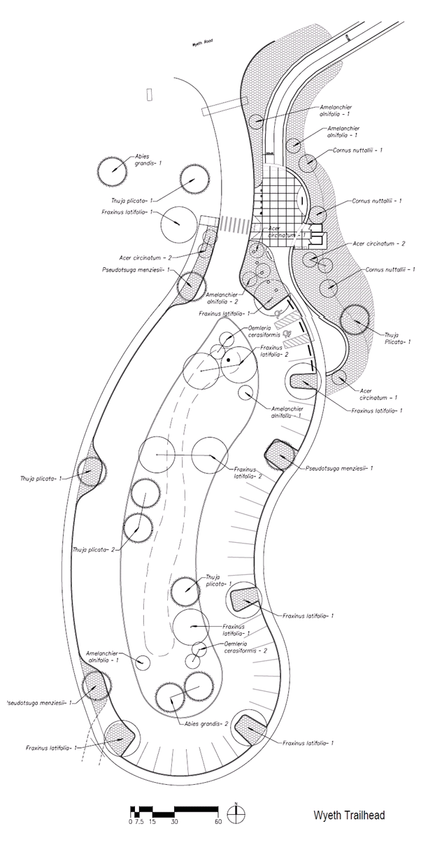
Wyeth Trailhead and Parking Lot
The planned parking lot at the Wyeth Trailhead incorporates a number of planting locations that encompass approximately one acre in area, including a drainage catch basin in the center and nine to twelve distinct planting pockets integrated into the outer curb. This area, more so than any other along the project, is designed with an eye toward more traditional landscape and horticultural practices. RST will work closely with Walker Macy to maintain public safety and line-of-sight while creating multi-seasonal interest.
RST will conduct weed control throughout the area prior to planting, especially near the entrance. There is currently a robust population of Scotch broom growing along Wyeth Road and continuing beyond the ownership boundary to the west. Although it would be ideal to treat the larger surrounding area (approximately four acres) to reduce future Scotch broom re-establishment, funding for this work is not currently available. Therefore, only the area referenced on the project plan sheets will receive treatment; less than one tenth of an acre. Once treated, the open area on the west side of the trailhead entrance will be planted with species that support pollinator-plant interactions (Table 1a). Efforts will be made to maintain visuals of the trailhead sign and entrance while blocking the view of the new vault toilet facility from the traveling public on Wyeth Road.
Contracting responsibility will be coordinated between WFLHD and RST. WFLHD will place 18” of weed-free topsoil or borrow material into all planting areas other than the planting pockets. The RST contactor will be responsible for providing weed-free topsoil to be combined with compost for use in the planting pockets and the two large planting beds on either side of the parking lot entrance. WFLHD will remove the non-native black locust trees currently on site.
Table 1b depicts tree and shrub species to be incorporated into the parking lot landscape plan. Native trees will be installed in the curb planting pockets and will be approximately 1-2” caliper and 4-6’ tall.
TABLE 1A. PLANTS TO POTENTIALLY BE USED IN REVEGETATION EFFORTS NEAR THE ENTRANCE TO THE WYETH TRAILHEAD PARKING LOT. ‘XX’ DENOTES SEEDING RATHER THAN TRANSPLANTING TO BE UTILIZED. STOCK TYPE DEFINITIONS ARE AS FOLLOW: ‘S’ SEED; ‘RL10’ 10 CUBIC INCH CONTAINER VOLUME; ‘D27’ 27 CUBIC INCH CONTAINER VOLUME; ‘D40’ 40 CUBIC INCH CONTAINER VOLUME; ‘#1’ ONE GALLON CONTAINER; ‘#5’ FIVE GALLON CONTAINER; ‘B&B’ BALLED AND BURLAPPED.
| Common |
Botanical |
Zone |
Stock Type |
Spacing
(on center) |
| common yarrow |
Achillea millefolium var.
occidentalis |
A |
S |
XX |
| pearly everlasting |
Anaphalis margaritacea |
A |
S |
XX |
| narrow-leaf milkweed |
Asclepias fascicularis |
A |
S, RL10 |
4" |
| showy milkweed |
Asclepias speciosa |
A |
S, RL10 |
4" |
| aster |
Aster spp. |
A |
S |
XX |
| mountain brome |
Bromus carinatus |
A |
S |
XX |
| Howell's reedgrass |
Calamagrostis howellii |
A |
S |
XX |
| Pacific dogwood |
Cornus nuttallii |
B |
#1 |
15’ |
| blue wildrye |
Elymus glaucus ssp. glaucus |
A |
S |
XX |
| smooth alumroot |
Heuchera glabra |
A |
S |
4” |
| lupine |
Lupinus latifolius. |
A |
S |
4” |
| creeping Oregon grape |
Mahonia repens |
A |
D27 |
4' |
| Sandberg’s bluegrass |
Poa secunda |
A |
S |
XX |
| self heal |
Prunella vulgaris |
A |
S |
XX |
| checkermallow |
Sidalcea spp. |
A |
RL10 |
XX |
| goldenrod |
Solidago canadensis |
A |
S |
XX |
| fringecups |
Tellima grandiflora |
A |
RL10 |
4” |
| western serviceberry |
Amelanchier alnifolia |
B |
#1, #5 |
8’ |
| Pacific dogwood |
Cornus nuttallii |
B |
#1 |
15’ |
| oceanspray |
Holodiscus discolor |
B |
D40 |
8’ |
| Oregon grape |
Mahonia aquifolium |
B |
D27, D40 |
4’ |
| Douglas fir |
Pseudotsuga menziesii |
B |
D27, B&B |
15’ |
| red flowering currant |
Ribes sanguineum |
B |
#1, #5 |
4’ |
| baldhip rose |
Rosa gymnocarpa |
B |
D27, B&B |
4’ |
| common snowberry |
Symphoricarpos albus |
B |
D27, D40 |
4’ |
| trailing snowberry |
Symphoricarpos mollis |
B |
D27, D40 |
4' |
| western red cedar |
Thuja plicata |
B |
#1, B&B |
15' |
TABLE 1B. PLANTS TO BE USED IN THE WYETH TRAILHEAD PARKING LOT, INCLUDING THE DRAINAGE BASIN. ‘XX’ DENOTES SEEDING RATHER THAN TRANSPLANTING TO BE UTILIZED. STOCK TYPE DEFINITIONS ARE AS FOLLOW: ‘S’ SEED; ‘RL10’ 10 CUBIC INCH CONTAINER VOLUME; ‘D27’ 27 CUBIC INCH CONTAINER VOLUME; ‘D40’ 40 CUBIC INCH CONTAINER VOLUME; ‘#1’ ONE GALLON CONTAINER; ‘#5’ FIVE GALLON CONTAINER; ‘B&B’ BALLED AND BURLAPPED.
| Common |
Botanical |
Zone |
Stock Type |
Spacing
(on center) |
| common yarrow |
Achillea millefolium var.
occidentalis |
A |
S |
XX |
| narrow-leaf milkweed |
Asclepias fascicularis |
A |
S, RL10 |
4" |
| showy milkweed |
Asclepias speciosa |
A |
S, RL10 |
4" |
| creeping Oregon grape |
Mahonia repens |
A |
D27, D40 |
4' |
| western sword fern |
Polystichum munitum |
A |
Short 4, #1 |
4' |
| fringecups |
Tellima grandiflora |
A |
RL10 |
4” |
| grand fir |
Abies grandis |
B |
#1, B&B |
15’ |
| vine maple |
Acer circinatum |
B |
#1, #5 |
8’ |
| western serviceberry |
Amelanchier alnifolia |
B |
#1, #5 |
8’ |
| redosier dogwood |
Cornus sericea spp. sericea |
B |
D27, D40 |
8’ |
| Oregon ash |
Fraxinus latifolia |
B |
#1, #5 |
15’ |
| oceanspray |
Holodiscus discolor |
B |
D40 |
8’ |
| Oregon grape |
Mahonia aquifolium |
B |
D27, D40 |
4’ |
| osoberry |
Oemleria cerasiformis |
B |
#1, #5 |
8’ |
| ninebark |
Physocarpus capitatus |
B |
#1, #5 |
8’ |
| Douglas fir |
Pseudotsuga menziesii |
B |
D-27, B&B |
15’ |
| red flowering currant |
Ribes sanguineum |
B |
#1, #5 |
4’ |
| thimbleberry |
Rubus parviflorus |
B |
D27, D40 |
4’ |
| elderberry |
Sambucus nigra |
B |
D27 |
8’ |
| common snowberry |
Symphoricarpos albus |
B |
D27, D40 |
4’ |
| trailing snowberry |
Symphoricarpos mollis |
B |
D27, D40 |
4' |
| western red cedar |
Thuja plicata |
B |
#1, B&B |
15' |
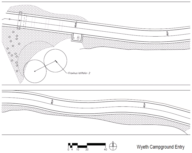
Wyeth Campground Entrance and Gorton Creek Bridge
The trail will cross the existing entrance to the Wyeth Campground and continue toward the east over the newly constructed Gorton Creek Bridge. WFLHD will install a water filling station near the Wyeth Campground entrance, adjacent to the grassy campground overflow area.
They will also install a split-railed fence, positioned about halfway between the edge of the planting area and the edge of the trail along the length of the overflow area. At the request of the USFS (Columbia River Gorge National Scenic Area), RST will treat the planting area between the grassy overflow area and the trail with a mix of low growing shrubs, forbs, and clumping grasses. These will be planted sparsely and randomly in order to assimilate the surrounding environment, yet densely enough to provide visual and physical separation between the overflow area and the trail.
RST will install riparian plantings in disturbed ground at and near the new Gorton Creek Bridge. In an effort to maintain adequate water flow yet prevent backup, WFLHD has determined no live staking will occur in the rip-rapped areas. All other construction related areas near the creek will be planted. Table 2 below depicts the suite of species that is available for use in these areas.
TABLE 2. THE SUITE OF SPECIES AVAILABLE FOR PLANTING AT THE WYETH CAMPGROUND AND GORTON CREEK. STOCK TYPE DEFINITIONS ARE AS FOLLOW: ‘S’ SEED; ‘RL10’ 10 CUBIC INCH CONTAINER VOLUME; ‘D27’ 27 CUBIC INCH CONTAINER VOLUME; ‘D40’ 40 CUBIC INCH CONTAINER VOLUME; ‘#1’ ONE GALLON CONTAINER; ‘#5’ FIVE GALLON CONTAINER; ‘B&B’ BALLED AND BURLAPPED.
| Common |
Botanical |
Zone |
Stock Type |
Spacing
(on center) |
| common yarrow |
Achillea millefolium var.
occidentalis |
A |
S |
XX |
| pearly everlasting |
Anaphalis margaritacea |
A |
S |
XX |
| narrow-leaf milkweed |
Asclepias fascicularis |
A |
S, RL10 |
4" |
| showy milkweed |
Asclepias speciosa |
A |
S, RL10 |
4" |
| mountain brome |
Bromus carinatus |
A |
S |
XX |
| Howell's reedgrass |
Calamagrostis howellii |
A |
S |
XX |
| blue wildrye |
Elymus glaucus ssp. glaucus |
A |
S |
XX |
| lupine |
Lupinus latifolius |
A |
S |
4" |
| creeping Oregon grape |
Mahonia repens |
A |
D27, D40 |
4' |
| Sandberg’s bluegrass |
Poa secunda |
A |
S |
XX |
| licorice fern |
Polypodium glycyrrhiza |
A |
Short 4 |
2' |
| western sword fern |
Polystichum munitum |
A |
Short 4, #1 |
4' |
| goldenrod |
Solidago canadensis |
A |
S |
XX |
| fringecups |
Tellima grandiflora |
A |
RL10 |
4" |
| vine maple |
Acer circinatum |
B |
#1, #5 |
8' |
| western serviceberry |
Amelanchier alnifolia |
B |
#1, #5 |
8' |
| redosier dogwood |
Cornus sericea spp. sericea |
B |
D27, D40 |
8' |
| Oregon ash |
Fraxinus latifolia |
B |
#1, #5 |
15' |
| oceanspray |
Holodiscus discolor |
B |
D40 |
8' |
| Oregon grape |
Mahonia aquifolium |
B |
D27, D40 |
4' |
| osoberry |
Oemleria cerasiformis |
B |
#1, #5 |
8' |
| Douglas fir |
Pseudotsuga menziesii |
B |
D27, B&B |
15' |
| thimbleberry |
Rubus parviflorus |
B |
D27, D40 |
4' |
| elderberry |
Sambucus nigra |
B |
D27 |
8' |
| common snowberry |
Symphoricarpos albus |
B |
D27, D40 |
4' |
| trailing snowberry |
Symphoricarpos mollis |
B |
D27, D40 |
4' |
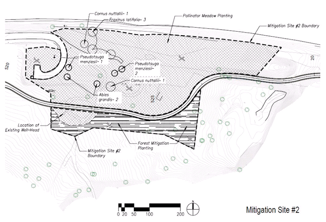
Mitigation Site #2
The open area of approximately five acres, less than half a mile east of the Wyeth Trailhead and parking lot, is designated as a mitigation site. Restoration of this area will not only serve as mitigation for impacts incurred as a result of the project, but will also address Section 3 of the 2014 Presidential Memorandum “Creating a Federal Strategy to Promote the Health of Honey Bees and Other Pollinators” which provides directive to increase and improve pollinator habitat. Plant species that provide feeding, nesting, resting, and rearing (e.g., host plant) benefits to pollinating insects will be utilized to support and encourage plant-pollinator interactions. To this end, attention will be paid not only to nectar producing plants but also to plant architecture, the creation of micro-habitats and climates through the use of large and small woody material, depressions to retain moisture, areas of vegetative refuge, patches of bare ground (necessary for some ground nesting pollinator species), as well as other pollinator sustaining habitat characteristics.
Given the location of this project, two pollinator species of conservation concern will be supported explicitly. First, the imperiled western bumble bee (Bombus occidentalis) will be supported in this important part of its remaining range by providing a large and diverse resource of nectaring plants. Second, and more specifically, we will create breeding habitat to support the imperiled Monarch butterfly (Danaus plexippus). Milkweed is the only known plant genus to serve as host plant for the Monarchs in the lower 48 states. We will incorporate two species of milkweed (Asclepias fascicularis and A. speciosa) in the plantings at Mitigation Site #2, upon which Monarchs may lay their eggs. Critically, the local area which includes other nearby locations in the Columbia River Gorge, is a known Monarch migration and breeding area with observations of Monarchs close to the project area.
Mitigation Site #2 includes a pump house, a wellhead, and remnants of old buildings including steps, foundations, etc. These artifacts will remain in place, as is. There are also a number of old roads, the majority of which are gravel/crushed aggregate. WFLHD will remove the material from the old road prisms, spread shredded woody material over the entire mitigation site (4-6” deep), and incorporate the material to a depth of at least 18” by either ripping or using an excavator bucket.
Aesthetic augmentation will include the creation of an earthen berm by WFLHD to screen the pump house, and RST will select and install appropriate vegetation to enhance this screening. Topographic sculpting will create terrain variation to mimic existing conditions found elsewhere on the project site. Plants will be installed in the pollinator meadow in random groupings with some individual plants interspersed throughout, or broadcast seeded to create a natural appearing end meadow-woodland complex.
Because of the very different light and canopy regimes at the edge of the existing forest that surrounds the meadow, a different suite of species will be utilized in this area than those in the open habitat. There is a desire among the partners involved with this project to leave the area of Mitigation Site #2 somewhat open and create a meadow-like habitat to support the previously discussed pollinator initiatives. As such, plant species installed at this site will include more forbs, low shrubs, and native grasses than trees. It is expected that without regular maintenance the natural seed rain from the surrounding trees will eventually convert the open area into a treed area over time. This will not be facilitated through active revegetation efforts by RST, however.
The species suite to be utilized in pollinator meadow of Mitigation Site #2 will include some or all of the plants in Table 3a below. The mix used for the forested ecotone is reflected in Table 3b.
TABLE 3A. POTENTIAL PLANTS TO BE USED IN REVEGETATION EFFORTS TO ENHANCE POLLINATOR-PLANT INTERACTIONS AT THE OPEN HABITAT OF MITIGATION SITE #2. ‘XX’ DENOTES SEEDING RATHER THAN TRANSPLANTING TO BE UTILIZED. STOCK TYPE DEFINITIONS ARE AS FOLLOW: ‘S’ SEED; ‘RL10’ 10 CUBIC INCH CONTAINER VOLUME; ‘D27’ 27 CUBIC INCH CONTAINER VOLUME; ‘D40’ 40 CUBIC INCH CONTAINER VOLUME; ‘#1’ ONE GALLON CONTAINER; ‘#5’ FIVE GALLON CONTAINER; ‘B&B’ BALLED AND BURLAPPED.
| Common |
Botanical |
Zone |
Stock Type |
Spacing
(on center) |
| common yarrow |
Achillea millefolium var.
occidentalis |
A |
S |
XX |
| pearly everlasting |
Anaphalis margaritacea |
A |
S |
XX |
| narrow-leaf milkweed |
Asclepias fascicularis |
A |
S, RL10 |
4" |
| showy milkweed |
Asclepias speciosa |
A |
S, RL10 |
4" |
| Aster |
Aster spp. |
A |
S |
XX |
| mountain brome |
Bromus carinatus |
A |
S |
XX |
| Howell's reedgrass |
Calamagrostis howellii |
A |
S |
XX |
| Pacific dogwood |
Cornus nuttallii |
B |
#1 |
15’ |
| blue wildrye |
Elymus glaucus ssp. glaucus |
A |
S |
XX |
| smooth alumroot |
Heuchera glabra |
A |
S |
4” |
| Lupine |
Lupinus latifolius |
A |
S |
4” |
| creeping Oregon grape |
Mahonia repens |
A |
D27 |
4' |
| Sandberg’s bluegrass |
Poa secunda |
A |
S |
XX |
| self heal |
Prunella vulgaris |
A |
S |
XX |
| checkermallow |
Sidalcea spp. |
A |
RL10 |
XX |
| goldenrod |
Solidago canadensis |
A |
S |
XX |
| fringecups |
Tellima grandiflora |
A |
RL10 |
4” |
| western serviceberry |
Amelanchier alnifolia |
B |
#1, #5 |
8’ |
| Pacific dogwood |
Cornus nuttallii |
B |
#1 |
15’ |
| oceanspray |
Holodiscus discolor |
B |
D40 |
8’ |
| Oregon grape |
Mahonia aquifolium |
B |
D27, D40 |
4’ |
| Douglas fir |
Pseudotsuga menziesii |
B |
D27, B&B |
15’ |
| red flowering currant |
Ribes sanguineum |
B |
#1, #5 |
4’ |
| baldhip rose |
Rosa gymnocarpa |
B |
D27, B&B |
4’ |
| common snowberry |
Symphoricarpos albus |
B |
D27, D40 |
4’ |
| trailing snowberry |
Symphoricarpos mollis |
B |
D27, D40 |
4' |
| western red cedar |
Thuja plicata |
B |
#1, B&B |
15' |
TABLE 3B. PLANTS TO BE UTILIZED AT THE ECOTONE BETWEEN THE EXISTING FORESTED AREA AND THE NEWLY CREATED POLLINATOR MEADOW AT MITIGATION SITE #2. STOCK TYPE DEFINITIONS ARE AS FOLLOW: ‘S’ SEED; ‘RL10’ 10 CUBIC INCH CONTAINER VOLUME; ‘D27’ 27 CUBIC INCH CONTAINER VOLUME; ‘D40’ 40 CUBIC INCH CONTAINER VOLUME; ‘#1’ ONE GALLON CONTAINER; ‘#5’ FIVE GALLON CONTAINER; ‘B&B’ BALLED AND BURLAPPED.
| Common |
Botanical |
Zone |
Stock Type |
Spacing
(on center) |
| creeping Oregon grape |
Mahonia repens |
A |
D27, D40 |
4' |
| licorice fern |
Polypodium glycyrrhiza |
A |
Short 4 |
2' |
| western sword fern |
Polystichum munitum |
A |
Short 4, #1 |
4' |
| grand fir |
Abies grandis |
B |
#1, B&B |
15' |
| vine maple |
Acer circinatum |
B |
#1, #5 |
8' |
| western serviceberry |
Amelanchier alnifolia |
B |
#1, #5 |
8' |
| Pacific dogwood |
Cornus nuttallii |
B |
#1 |
15' |
| Oregon ash |
Fraxinus latifolia |
B |
#1, #5 |
15' |
| Oregon grape |
Mahonia aquifolium |
B |
D27, D40 |
4' |
| osoberry |
Oemleria cerasiformis |
B |
#1, #5 |
8' |
| western white pine |
Pinus monticola |
B |
D27 |
15' |
| Douglas fir |
Pseudotsuga menziesii |
B |
D27, B&B |
15' |
| red flowering currant |
Ribes sanguineum |
B |
#1, #5 |
4' |
| thimbleberry |
Rubus parviflorus |
B |
D27, D40 |
4' |
| elderberry |
Sambucus nigra |
B |
D27 |
8' |
| common snowberry |
Symphoricarpos albus |
B |
D27, D40 |
4' |
Stepped, Plantable MSE Wall
There is a stepped, plantable mechanically stabilized earth (MSE) wall to be constructed from approximately ST 44+05 to ST 63+88. The height of this wall will vary from about 10-30 feet tall and it is planned to be 1,983 linear feet long. WFLHD will place topsoil along the entire base of the wall, burying the first two to three steps and creating a 3:1 slope (H:V). RST will place weed-free topsoil mixed with compost (1:1) over the remaining exposed wall to provide a continuous slope and effectively eliminating the appearance of steps. Shrubs and small trees will be randomly planted at the toe of the slope to provide vegetative screening, as well as sparsely planted along the newly created slope. RST will hydroseed the entire area with hydromulch, grass and forb seed, and tackifier. Irrigation will be an option item should the RST specialist determine it necessary for the survival of the plants. See Table 4 for the suite of potential restoration plants to be used on the plantable MSE wall.
TABLE 4. PLANT SUITE THAT MIGHT BE UTILIZED FOR VEGETATING THE STEPPED, PLANTABLE MSE WALL. ‘XX’ DENOTES SEEDING RATHER THAN TRANSPLANTING TO BE UTILIZED. STOCK TYPE DEFINITIONS ARE AS FOLLOW: ‘S’ SEED; ‘RL10’ 10 CUBIC INCH CONTAINER VOLUME; ‘D27’ 27 CUBIC INCH CONTAINER VOLUME; ‘D40’ 40 CUBIC INCH CONTAINER VOLUME; ‘#1’ ONE GALLON CONTAINER; ‘#5’ FIVE GALLON CONTAINER; ‘B&B’ BALLED AND BURLAPPED.
| Common |
Botanical |
Zone |
Stock Type |
Spacing
(on center) |
| common yarrow |
Achillea millefolium var.
occidentalis |
A |
S |
XX |
| pearly everlasting |
Anaphalis margaritacea |
A |
S |
XX |
| mountain brome |
Bromus carinatus |
A |
S |
XX |
| blue wildrye |
Elymus glaucus ssp. glaucus |
A |
S |
XX |
| smooth alumroot |
Heuchera glabra |
A |
RL10 |
4" |
| creeping Oregon grape |
Mahonia repens |
A |
D27, D40 |
4' |
| Sandberg’s bluegrass |
Poa secunda |
A |
S |
XX |
| licorice fern |
Polypodium glycyrrhiza |
A |
Short 4 |
2' |
| western sword fern |
Polystichum munitum |
A |
Short 4, #1 |
4' |
| fringecups |
Tellima grandiflora |
A |
RL10 |
4" |
| western serviceberry |
Amelanchier alnifolia |
B |
#1, #5 |
8' |
| Oregon grape |
Mahonia aquifolium |
B |
D27, D40 |
4' |
| osoberry |
Oemleria cerasiformis |
B |
#1, #5 |
8' |
| Douglas fir |
Pseudotsuga menziesii |
B |
D27, B&B |
15' |
| red flowering currant |
Ribes sanguineum |
B |
#1, #5 |
4' |
| thimbleberry |
Rubus parviflorus |
B |
D27, D40 |
4' |
| common snowberry |
Symphoricarpos albus |
B |
D27, D40 |
4' |
| trailing snowberry |
Symphoricarpos mollis |
B |
D27, D40 |
4' |
Summit Creek Viaduct
The extensive pedestrian viaduct planned near Summit Creek will present specific challenges to revegetation efforts. The viaduct will cover approximately 0.16 acres and will prevent precipitation and direct sunlight from reaching the surface of the ground below the viaduct deck. Currently there are micro-habitats that have a variety of vegetation growing at the toe slope of rock walls. Soil accumulates at the junction of the rock wall and ground, and precipitation drips down the face of the rock; both contribute to the ability to support plant life. Revegetation efforts will take advantage of similar micro-habitats under the viaduct, utilize shade tolerant plant species, and incorporate organic matter into the soil to aid in moisture retention. The primary contractor will place topsoil conserved from the project at the viaduct footings to bring the soil up to existing native soil depths and provide planting medium. Please refer to Table 5 for candidate species for planting near the Summit Creek Viaduct.
TABLE 5. PLANTS POTENTIALLY TO BE USED IN REVEGETATION EFFORTS AT THE SUMMIT CREEK VIADUCT. ‘XX’ DENOTES SEEDING RATHER THAN TRANSPLANTING TO BE UTILIZED. STOCK TYPE DEFINITIONS ARE AS FOLLOW: ‘S’ SEED; ‘RL10’ 10 CUBIC INCH CONTAINER VOLUME; ‘D27’ 27 CUBIC INCH CONTAINER VOLUME; ‘D40’ 40 CUBIC INCH CONTAINER VOLUME; ‘#1’ ONE GALLON CONTAINER; ‘#5’ FIVE GALLON CONTAINER; ‘B&B’ BALLED AND BURLAPPED.
| Common |
Botanical |
Zone |
Stock Type |
Spacing
(on center) |
| common yarrow |
Achillea millefolium var.
occidentalis |
A |
S |
XX |
| pearly everlasting |
Anaphalis margaritacea |
A |
S |
XX |
| smooth alumroot |
Heuchera glabra |
A |
RL10 |
4" |
| creeping Oregon grape |
Mahonia repens |
A |
D27, D40 |
4' |
| licorice fern |
Polypodium glycyrrhiza |
A |
Short 4 |
2' |
| western sword fern |
Polystichum munitum |
A |
Short 4, #1 |
4' |
| fringecups |
Tellima grandiflora |
A |
RL10 |
4" |
| western serviceberry |
Amelanchier alnifolia |
B |
#1, #5 |
8' |
| redosier dogwood |
Cornus sericea spp. sericea |
B |
D27, D40 |
8' |
| oceanspray |
Holodiscus discolor |
B |
D40 |
8' |
| Oregon grape |
Mahonia aquifolium |
B |
D27, D40 |
4' |
| osoberry |
Oemleria cerasiformis |
B |
#1, #5 |
8' |
| baldhip rose |
Rosa gymnocarpa |
B |
D27, D40 |
4' |
| thimbleberry |
Rubus parviflorus |
B |
D27, D40 |
4' |
| common snowberry |
Symphoricarpos albus |
B |
D27, D40 |
4' |
HCRHST Embankments (Cuts and Fills) and Planned Idle Spots
In coordination with WFLHD, RST will provide the primary contractor with a native grass and forb seed mix to use on exposed trail embankments during and post construction as a part of erosion control measures. RST will install native plants (Table 6) throughout the construction limits once construction activity ceases. Due to the effort to create a natural appearing setting, native shrubs and forbs will be planted in groupings, spread at varying intervals, and in a mix of species. Some areas, such as near Shell Rock Mountain and the new idle spots might not require any plant installation other than seed for erosion control efforts. The planting plans from Walker Macy will be referenced to maintain line-of-site and safety, utilizing shorter plants directly adjacent to the trail and creating a natural appearing visual experience.
Slopes of greater than average length or slope (1:2) will receive a mulch application of weed- free compost or shredded woody material, applied to a depth of 1-2 inches, and a final grass seed application. The addition of mulch and final seeding will assist to preserve slope integrity, decrease weed recruitment and establishment, and facilitate moisture retention. Practices that increase soil compaction are best avoided and it is ideal that slopes be left in a roughened condition (i.e., use a toothed rock bucket rather than smoothing bucket, avoid back
blading, etc.).
TABLE 6. POTENTIAL PLANT SPECIES TO BE UTILIZED ON CUT/FILL SLOPES AND PLANNED IDLE SPOTS OF HISTORIC COLUMBIA RIVER HIGHWAY STATE TRAIL. ‘XX’ DENOTES SEEDING RATHER THAN TRANSPLANTING TO BE UTILIZED. STOCK TYPE DEFINITIONS ARE AS FOLLOW: ‘S’ SEED; ‘RL10’ 10 CUBIC INCH CONTAINER VOLUME; ‘D27’ 27 CUBIC INCH CONTAINER VOLUME; ‘D40’ 40 CUBIC INCH CONTAINER VOLUME; ‘#1’ ONE GALLON CONTAINER; ‘#5’ FIVE GALLON CONTAINER; ‘B&B’ BALLED AND BURLAPPED.
| Common |
Botanical |
Zone |
Stock Type |
Spacing
(on center) |
| common yarrow |
Achillea millefolium var.
occidentalis |
A |
S |
XX |
| pearly everlasting |
Anaphalis margaritacea |
A |
S |
XX |
| mountain brome |
Bromus carinatus |
A |
S |
XX |
| Howell's reedgrass |
Calamagrostis howellii |
A |
S |
XX |
| blue wildrye |
Elymus glaucus ssp. glaucus |
A |
S |
XX |
| lupine |
Lupinus latifolius |
A |
S |
4" |
| creeping Oregon grape |
Mahonia repens |
A |
D27, D40 |
4' |
| Sandberg’s bluegrass |
Poa secunda |
A |
S |
XX |
| licorice fern |
Polypodium glycyrrhiza |
A |
Short 4 |
2' |
| western sword fern |
Polystichum munitum |
A |
Short 4, #1 |
4' |
| self heal |
Prunella vulgaris |
A |
S |
XX |
| fringecups |
Tellima grandiflora |
A |
RL10 |
4" |
| Oregon grape |
Mahonia aquifolium |
B |
D27, D40 |
4' |
| baldhip rose |
Rosa gymnocarpa |
B |
D27, D40 |
4' |
| thimbleberry |
Rubus parviflorus |
B |
D27, D40 |
4' |
| common snowberry |
Symphoricarpos albus |
B |
D27, D40 |
4' |
| trailing snowberry |
Symphoricarpos mollis |
B |
D27, D40 |
4' |
Staging Area(s)
The potential suite of plant species for restoration of staging areas is diverse. The staging area(s) can encompass a variety of environments with differing light regimes, infiltration rates, and habitats. Other than weed control, most revegetation efforts will be delayed until after staging equipment and material are removed by WFLHD. Table 7 shows the species that may be used in revegetation efforts of staging areas.
TABLE 7. PROPOSED REVEGETATION SPECIES FOR STAGING AREA(S) UTILIZED. ‘XX’ DENOTES SEEDING RATHER THAN TRANSPLANTING TO BE UTILIZED. STOCK TYPE DEFINITIONS ARE AS FOLLOW: ‘S’ SEED; ‘RL10’ 10 CUBIC INCH CONTAINER VOLUME; ‘D27’ 27 CUBIC INCH CONTAINER VOLUME; ‘D40’ 40 CUBIC INCH CONTAINER VOLUME; ‘#1’ ONE GALLON CONTAINER; ‘#5’ FIVE GALLON CONTAINER; ‘B&B’ BALLED AND BURLAPPED.
| Common |
Botanical |
Zone |
Stock Type |
Spacing
(on center) |
| common yarrow |
Achillea millefolium var.
occidentalis |
A |
S |
XX |
| pearly everlasting |
Anaphalis margaritacea |
A |
S |
XX |
| mountain brome |
Bromus carinatus |
A |
S |
XX |
| Howell's reedgrass |
Calamagrostis howellii |
A |
S |
XX |
| blue wildrye |
Elymus glaucus ssp. glaucus |
A |
S |
XX |
| lupine |
Lupinus latifolius |
A |
S |
4" |
| creeping Oregon grape |
Mahonia repens |
A |
D27, D40 |
4' |
| Sandberg’s bluegrass |
Poa secunda |
A |
S |
XX |
| licorice fern |
Polypodium glycyrrhiza |
A |
Short 4 |
2' |
| western sword fern |
Polystichum munitum |
A |
Short 4, #1 |
4' |
| goldenrod |
Solidago canadensis |
A |
S |
XX |
| fringecups |
Tellima grandiflora |
A |
RL10 |
4" |
| grand fir |
Abies grandis |
B |
#1, B&B |
15' |
| vine maple |
Acer circinatum |
B |
#1, #5 |
8' |
| western serviceberry |
Amelanchier alnifolia |
B |
#1, #5 |
8' |
| Pacific dogwood |
Cornus nuttallii |
B |
#1 |
15' |
| redosier dogwood |
Cornus sericea spp. sericea |
B |
D27, D40 |
8' |
| Oregon ash |
Fraxinus latifolia |
B |
#1, #5 |
15' |
| oceanspray |
Holodiscus discolor |
B |
D40 |
8' |
| Oregon grape |
Mahonia aquifolium |
B |
D27, D40 |
4' |
| osoberry |
Oemleria cerasiformis |
B |
#1, #5 |
8' |
| Douglas fir |
Pseudotsuga menziesii |
B |
D27, B&B |
15' |
| red flowering currant |
Ribes sanguineum |
B |
#1, #5 |
4' |
| thimbleberry |
Rubus parviflorus |
B |
D27, D40 |
4' |
| elderberry |
Sambucus nigra |
B |
D27 |
8' |
| common snowberry |
Symphoricarpos albus |
B |
D27, D40 |
4' |
| trailing snowberry |
Symphoricarpos mollis |
B |
D27, D40 |
4' |
| western red cedar |
Thuja plicata |
B |
#1, B&B |
15' |
Back to top
NON-NATIVE PLANT CONTROL
Weed Control Plan
All Oregon Noxious Class ‘A’ and ‘B’ weeds will be treated within the construction limits (Appendix Three). The one exception to this is herb Robert (Geranium robertianum) which will not be targeted for treatment, as determined during site visits with WFLHD, ODOT, CH2M, CRGNSA, and RST. Of the targeted Class A and B species the following Class B species have been noted within Segments A-C: Canada thistle (Cirsium arvense), English ivy, Himalayan blackberry, Scotch broom, perennial peavine (Lathyrus latifolius), and St.
Johnswort (Hypericum perforatum). Although not listed by the State, periwinkle (Vinca minor) will also be targeted for control, as will other species that appear to impede restoration efforts. Table 8 provides an estimated schedule of non-native plant treatment.
Only approved herbicides and surfactants will be used and all aquatic setbacks adhered to. Personnel from partnering agencies including the Mt. Hood National Forest, Columbia River Gorge National Scenic Area, Oregon Parks and Recreation Department, and Oregon Department of Transportation will be consulted regarding permissible herbicides and surfactants.
Himalayan blackberry
Himalayan blackberry will be sprayed with glyphosate or triclopyr + surfactant from a backpack sprayer or an ATV. In the area of Mitigation Site #2 the plants will then mowed no sooner than 3 weeks after the first spray treatment, allowed to re-sprout, and chemically treated again. The area with the greatest concentration of Himalayan blackberry is Mitigation Site #2, but the plants do occur throughout the segments. RST will chemically treat these populations where they occur, but most likely will not utilize mowing.
Scotch Broom
Scotch broom populations are most robust at the Wyeth Trailhead/parking lot and at Mitigation Site #2. There are plants scattered throughout other areas of segments A-C, as well as along Wyeth Road near the proposed Wyeth Trailhead and parking lot. Treatments should include these plants that are in close proximity along Wyeth Road to prevent immediate recolonization of Wyeth parking lot. Plants less than three feet in length will receive herbicide treatment and left in place; those greater than three feet in length will be wrenched out, including as much root as is possible, and removed from the project site.
Additional weeds
In addition to the above, periwinkle has been observed scattered throughout segments A-C. Populations of these plants will be treated at the same time as the others previously discussed. Periwinkle will be sprayed with either glyphosate or triclopyr.
Back to top
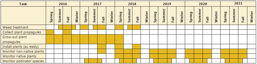
Monitoring Plan
The agreed upon parameters to evaluate native plant revegetative success for this project are percent cover and plant stem density (Table 8). Because of this, monitoring will be conducted at 1/100th acre plots distributed randomly throughout the project area. In an effort to ascertain unbiased data the plots will not be fixed and will occur in different locations from year to year. A minimum of ten (10) plots will be analyzed within the boundaries of Mitigation Site #2 and ten (10) additional plots will be randomly distributed throughout the project area. Native species cover and stem density will be recorded within each plot, as well as other variables.
Noxious weed success criteria is total percent cover. Prior to construction RST will conduct ocular estimation of non-native plant cover within Mitigation Site #2 and repeat annually. Percent cover of each non-native species will be noted within each plot described above; at Mitigation Site #2 as well as throughout the project area. Refer to Table 9 for an estimated monitoring timeline and Table 10 for overall costs associated with this project.
In addition to native and non-native plants, monitoring protocol for pollinating insects will be conducted at the newly created pollinator meadow of Mitigation Site #2. Of particular interest are native bees and Monarch butterflies. The streamlined bee monitoring procedure developed by the Xerces Society will be utilized twice per year after plant establishment. During the surveys all pollinators observed will be noted including wasps, flies, honey bees, native bees, Monarch butterflies, other butterflies, moths, ants, etc.
Back to top
Success Criteria
TABLE 8. CRITERIA UPON WHICH NATIVE AND NON-NATIVE PLANT SUCCESS WILL BE MEASURED.
| Item |
Benchmark |
Timeframe |
Notes |
| Noxious weed control |
≤ 20% cover |
By year 3 |
Oregon Noxious Weed List A and B |
| Noxious weed control |
≤ 10% cover |
By year 5 |
Oregon Noxious Weed List A and B |
| Planting density |
≥ 400 woody stems per
acre |
By year 5 |
|
| Native plant percent cover |
≥ 20% cover |
By year 1 |
|
| Native plant percent cover |
≥ 40% cover |
By year 3 |
|
| Native plant percent cover |
≥ 80% cover |
By year 5 |
|
| Native plant diversity |
≥ 5 woody species
comprise ≥ 5% total cover |
By year 5 |
|
| If performance standards not met |
Use of adaptive management practices |
As early as detected |
May include replanting, reseeding, noxious weed removal, improvement of soil quality,
irrigation, mulch. |
Back to top
Approximate Timeline & Budget
TABLE 9. THE FOLLOWING TABLE DEPICTS THE ESTIMATED TIMELINE OF REVEGETATION EFFORTS PLANNED BY RST WITHIN SEGMENTS A-C OF THE HISTORIC COLUMBIA RIVER HIGHWAY STATE TRAIL.
Back to top
Appendix One - Plant Species Suite
POTENTIAL SUITE OF PLANT SPECIES TO BE USED IN REVEGETATION EFFORTS OF SEGMENTS A-C OF HCRHST. STOCK TYPE DEFINITIONS ARE AS FOLLOW: ‘S’ SEED; ‘RL10’ 10 CUBIC INCH CONTAINER VOLUME; ‘D27’ 27 CUBIC INCH CONTAINER VOLUME; ‘D40’ 40 CUBIC INCH CONTAINER VOLUME; ‘#1’ ONE GALLON CONTAINER; ‘#5’ FIVE GALLON CONTAINER; ‘B&B’ BALLED AND BURLAPPED.
| Common |
Botanical |
Zone |
Stock Type |
Spacing
(on center) |
common yarrow |
Achillea millefolium var.
occidentalis |
A |
S |
XX |
pearly everlasting |
Anaphalis margaritacea |
A |
S |
XX |
narrow-leaf milkweed |
Asclepias fascicularis |
A |
S, RL10 |
4" |
showy milkweed |
Asclepias speciosa |
A |
S, RL10 |
4" |
Aster |
Aster spp. |
A |
S |
XX |
mountain brome |
Bromus carinatus |
A |
S |
XX |
Howell's reedgrass |
Calamagrostis howellii |
A |
S |
XX |
blue wildrye |
Elymus glaucus ssp. glaucus |
A |
S |
XX |
smooth alumroot |
Heuchera glabra |
A |
RL10 |
4" |
Lupine |
Lupinus latifolius |
A |
S |
4" |
creeping Oregon grape |
Mahonia repens |
A |
D27, D40 |
4' |
Sandberg’s bluegrass |
Poa secunda |
A |
S |
XX |
licorice fern |
Polypodium glycyrrhiza |
A |
Short 4 |
2' |
western sword fern |
Polystichum munitum |
A |
Short 4, #1 |
4' |
self heal |
Prunella vulgaris |
A |
S |
XX |
checkermallow |
Sidalcea spp. |
A |
S |
XX |
goldenrod |
Solidago canadensis |
A |
S |
XX |
fringecups |
Tellima grandiflora |
A |
RL10 |
4" |
grand fir |
Abies grandis |
B |
#1, B&B |
15' |
vine maple |
Acer circinatum |
B |
#1, #5 |
8' |
western serviceberry |
Amelanchier alnifolia |
B |
#1, #5 |
8' |
Pacific dogwood |
Cornus nuttallii |
B |
#1 |
15' |
redosier dogwood |
Cornus sericea spp. sericea |
B |
D27, D40 |
8' |
Oregon ash |
Fraxinus latifolia |
B |
#1, #5 |
15' |
oceanspray |
Holodiscus discolor |
B |
D40 |
8' |
Oregon grape |
Mahonia aquifolium |
B |
D27, D40 |
4' |
osoberry |
Oemleria cerasiformis |
B |
#1, #5 |
8' |
ninebark |
Physocarpus capitatus |
B |
#1, #5 |
8' |
western white pine |
Pinus monticola |
B |
D27 |
15' |
Douglas fir |
Pseudotsuga menziesii |
B |
D27, B&B |
15' |
red flowering currant |
Ribes sanguineum |
B |
#1, #5 |
4' |
baldhip rose |
Rosa gymnocarpa |
B |
D27, D40 |
4' |
thimbleberry |
Rubus parviflorus |
B |
D27, D40 |
4' |
elderberry |
Sambucus nigra |
B |
D27 |
8' |
common snowberry |
Symphoricarpos albus |
B |
D27, D40 |
4' |
trailing snowberry |
Symphoricarpos mollis |
B |
D27, D40 |
4' |
western red cedar |
Thuja plicata |
B |
#1, B&B |
15' |
Back to top
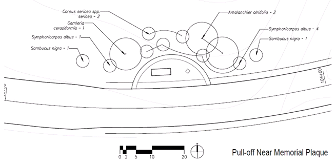
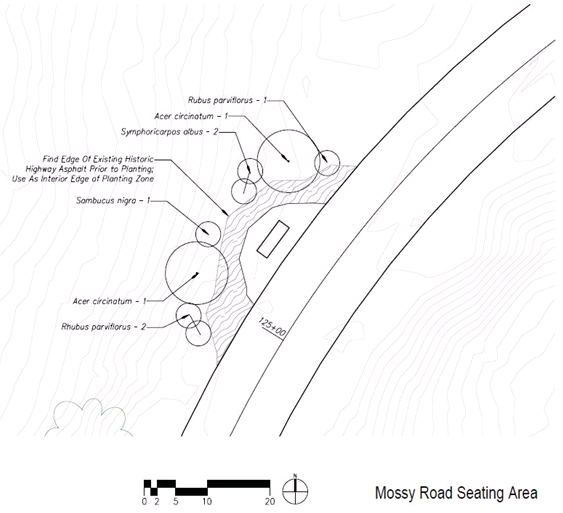
Appendix Two - Walker Macy Planting Plans
Wyeth Trailhead
Wyeth Campground Entry
Mitigation Site #2
Pull-off Near Memorial Plaque
Mossy Road Seating Area
Back to top
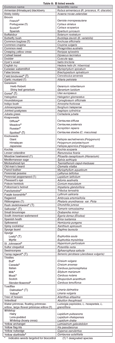
Appendix Three - Oregon Noxious Weed List
Table 1: A Listed Weeds
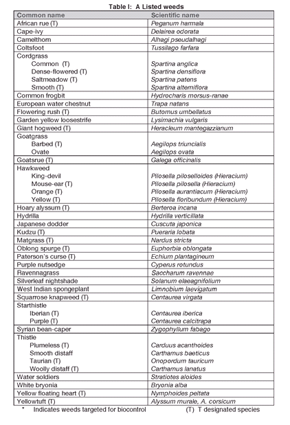
Table 2: B Listed Weeds
Back to top
References
The following resources were not cited directly, but were referenced in the development of this document.
Bennett, Max. 2007. Managing Himalayan blackberry in western Oregon riparian areas.
Oregon State University Extension Service, Oregon State University. Corvallis, Oregon.
Bergerson, Terry. 2012. Visitor survey of day-use visitors at Starvation Creek State Park.
Oregon Parks and Recreation Department.
Biggerstaff, Matthew and Christopher Beck. 2007. Effects of method of English ivy removal and seed addition on regeneration of vegetation in a southeastern Piedmont forest. The American Midland Naturalist 158: 206-220.
Binelli, Eliana K., Gholz, Henry L., and Mary L. Duryea. 2000. Chapter 4: Plant succession and disturbances in the urban forest ecosystem. In: Restoring the urban forest ecosystem. The School of Forest Resources and Conservation, Florida Cooperative Extension Service, Institute of Food and Agricultural Sciences, University of Florida.
CH2MHill, Inc. 2014. Wetlands/Waters delineation report, Historic Columbia River Highway State Trail Segments A-D. Columbia River Gorge National Scenic Area Task Order No. T-13-001, Modification 004, Task 3.8 Multi-Discipline IDIQ Contract No. DTFH70-10-D- 00020.
CH2MHill, Inc. 2014. Mitigation Plan: OR DOT CRGNSA 100(1) Historic Columbia River Highway State Trail (Segments A-D) Columbia River Gorge National Scenic Area Task Order No. T-13-001, Modification 006, Task 3.9 Multi-Discipline IDIQ Contract No.
DTFH70-10-D-00020.
CH2MHill, Inc. 2015. Draft Design Acceptance Package, Historic Columbia River Highway State Trail: Gorton Creek to Lindsey Creek (Segments A-C). Prepared for Western Federal Lands Highway Division and Oregon Department of Transportation.
Dlugosch, Katrina M. 2005. Understory community changes associated with English ivy invasions in Seattle’s urban parks. Northwest Science 79(1): 52-59.
Dobson, Robin. 2015. Personal communication. Email to author, April 20, 2015.
Flory, Luke S. and Keith Clay. 2009. Invasive plant removal method determines native plant community responses. Journal of Applied Ecology 46: 434-442.
Green, George L. 1981. Soil survey of Hood River County area, Oregon. United States Department of Agriculture, Soil Conservation Service, in cooperation with the Oregon Agricultural Experiment Station.
Hood River County Chamber of Commerce. Hood River County, About Hood River.
Hoodriver.org
Hopwood, Jennifer, Black, Scott, and Scott Fleury. 2016. Pollinators and roadsides: Best management practices for managers and decision makers. Prepared for the Federal Highway Administration.
Invasive plant species assessment working group. Invasive plant species fact sheet: Periwinkle
Vinca minor. www.invasivespecies.IN.gov
King County Noxious Weed Control Program. 2014. Himalyan blackberry best management Practices.
Michigan Department of Natural Resources. 2012. Invasive species- Best control practices: black locust (Robinia pseudoacacia).
Oregon Plant Atlas, Oregon Flora Project. Oregon State University. www.oregflora.org/atlas.php
Pollinator Health Task Force. 2015. National strategy to promote the health of honey bees and other pollinators. The White House.
Quatrefoil, Inc. 2010. The Historic Columbia River Highway State Trail plan- Wyeth to Hood River.
Steinfeld, David E., Riley, Scott A., Wilkinson, Kim M., Landis, Tom D., Riley, Lee E.. 2007.
Roadside revegetation: An integrated approach to establishing native plants. Federal Highway Administration, Western Federal Lands Highway Division report number FHWA-WFL/TD-07-005.
United States Department of Agriculture, Forest Service. 2009. Gifford Pinchot National Forest south zone invasive plant treatment 2009 implementation plan.
United States Department of the Interior, Bureau of Land Management. National seed strategy for rehabilitation and restoration. http://www.blm.gov/ut/st/en/prog/more/CPNPP/0/seedstrategy.html- content is no longer available.
Ward, K., Cariveau, E., May, M., Roswell, M., Vaughan, N., Williams, R., Winfree, R., Isaacs, and K. Gill. 2014. Streamlined bee monitoring protocol for assessing pollinator habitat.
Portland, OR: The Xerces Society for Invertebrate Conservation.
Wisconsin Department of Natural Resources. 2004. Black locust (Robinia pseudoacacia).
Back to top

